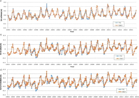
isprs archives XLII 4 W1 277 2016
Teks penuh
Gambar

Garis besar
Dokumen terkait
The primary aim of this study is to document the demographic parameters, the predominant injury mechanisms and severity, geographical positioning data (i.e coordinates of
The objectives of this articles were two-fold: first to investigate the characteristics of sediments in the Hulu Sungai Perak; second to correlate the side scan image with the
The large RMSEs for the RBCL configuration and the low RMSEs for the XS configuration confirm that as the data points become evenly spaced and covers more portions of the river,
Based on the criteria, the new moon is considered visible if the altitude at sunset is at least 2 o and the elongation between the moon and the sun is at least 3 o , or at
This paper especially goes into detail on the optimization of the image tracking algorithms, the development of the video-based AR player for the Android platform and the evaluation
In addition, instead of assuming that the travel of the compactor is free from any disturbance, the study takes into consideration of the actual expenses that were faced by the
The results from the test indicates that the GPS data in northern Sumatra and west-coast of Peninsular Malaysia for the period of seven years since the day of Nias 2005 and
With the availability of huge volumes of high resolution images and altimetry data covering the entire lunar surface, and with the development of new
