isprs annals IV 4 W2 215 2017
Teks penuh
Gambar
Garis besar
Dokumen terkait
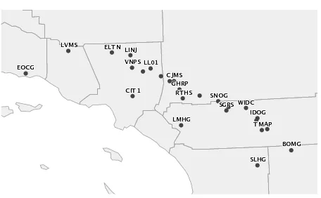
This paper examines the multi-spatiotemporal patterns of burglary crimes in Chicago between 2006 and 2016. Three spatial scales: police district, community and police beat,
Figure 10 and Figure 11 show Probplot-plot of Gamma and Lognormal distributions fitting to data with temporal resolution of 3 and 12 hourly and spatial resolution of 0.25 o
For example, ESRI’s commercial product ArcGIS has an estimated 615 stand-alone tools in 18 categories (Gao and Goodchild 2013), plus hundreds of other interactive
KEY WORDS: rapid intensification prediction, tropical cyclones, LSTM, deep learning, class imbalanced
Geohashing is a data encoding technique to produce spatial bounding boxes used for binning of nearby points based on Z-order curves (Morton, 1966). Unlike many of the other
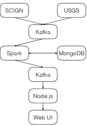
In order to handle missing values in time series, as well as the lack of considering temporal properties in machine learning models, we propose a spatiotemporal prediction
Looking now at the metrics of computational cost, efficiency, and utility we see that the Geohash and Hilbert SFC are pretty competitive and the choice between the two,
Following the successful first International Symposium on Spatiotemporal Computing held in July 2015 (ISSC’2015) at George Mason University, Fairfax, VA, the second International
