isprs annals IV 2 W1 83 2016
Teks penuh
Gambar

Garis besar
Dokumen terkait
1) While IndoorGML has more detailed subdivision, LADM provides larger spatial units but follow the borders of IndoorGML units (this would be considered to
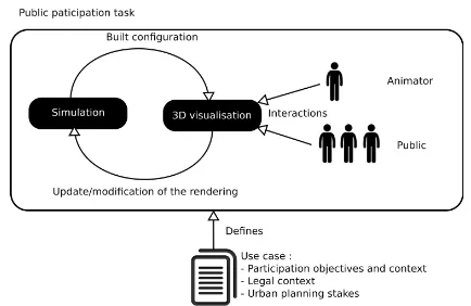
We present in the following section our method allow- ing to consider the indoor 3D space and its furnitures, and to ex- tract the actual free navigable space it contains,
In addition, a separate cloud consisting of non-vegetation features automatically derived using CANUPO classification algorithm (Brodu and Lague, 2012) was used to generate a
Six metrics are investigated in this study: Mean number of ver- tices/edges/faces per building (Metrics 1, 2 and 3); Mean number of vertices per face (4); Frequency distribution of
ISPRS Annals of the Photogrammetry, Remote Sensing and Spatial Information Sciences, Volume IV-2/W1, 2016 11th 3D Geoinfo Conference, 20–21 October 2016, Athens, Greece... For
As Geographic Information Systems (GIS) play a crucial role in managing spatial information about buildings and the flood parameters for assessment and visualisation of damage, in
Dynamizers support inlining of O&M data representing sen- sor observation values, which then are injected into the at- tributes of specific city objects.. This approach is useful
While this may have an impact when Coimbra try to identify the exact number of each specific case present in the Municipality, the fact that some users may not identify their
