CHAPTER 1
INTRODUCTION AND
LITERATURE REVIEW
1.1 Project Introduction
Global Position System (GPS) Mobile Tracking is an application of Global
Position System (GPS). This project basically will make the research and develop an
embedded controller for sending and retrieving GPS data. This project consist of two
part of hardware which the first part as a receiver and the second parts as a receiver and
transmitter. The second part of hardware will communicate with satellite to retrieve data
since then first part will act as receiver to receive and display data from transmitter at
Mobile phone.
Generally the Global Positioning System (GPS) is the only fully functional
complementary characteristics, which have been exploited in the design of integrated
GPS-inertial navigation and guidance systems. The GPS is made up of three parts, it is
satellites orbiting the Earth, control and monitoring stations on Earth. The GPS uses a
2
1.2 Objective of Project
Every project was proposed normally have their own objective or what they aim
for. In this GPS project there are three objectives as below:
• To study about GPS theory and application, investigate their structure and
understand concept of GPS system to create useful application base of sending and
retrieving GPS data.
• To develop a device with ability to detect location of an object using embedded
controller GPS system
• To develop a device with ability to find current location of moving objects and pass
that current location to user.
1.3 Problem Statement
Some products already available in the market today have their own ability and
weakness. In this Global Position System (GPS) Mobile Tracking, below are three
problems statement can be carried out in this project:
• Lack of security system. For example, alarm safety system just detects the thief but
do not have a system to overcome the problem such as prevent thief start the car and
etc.
• Current product available cannot trace where current position of vehicle if the car
stole. Thus, lost car is hard to find if stole.
• Wireless system controller application available now commonly used in limited
3
1.4 Scope of Project
This project scope is an application of Global Position Systems (GPS). This
project consist of two part, that’s parts are hardware and software part. • Hardware part will consist of two main parts.
- First part is transmitter and receiver, and the second part as a receiver.
• Software part used in this project is mikroC, proteus, MiniGPS_1.32, and Win
PIC.
• This project should be able to operate in wide area distance. As long as coverage is available, this GPS should be able to operate properly.
• The capability of these systems is should be able to track, and transmitted current location of object in format latitude and longitude to receiver when receiver
retrieve that data using SMS instruction.
1.5 Literature Review
Literature review has been conducted prior to undertaking this project to obtain
the information of the technology available and the methodologies that used by the other
researchers on the same topic around the world. This chapter provides the summary of
literature reviews on key topics related to the Global Position System (GPS) Mobile
Tracking.
Recently, there are various types of Global Position System (GPS) mobile
Tracking in the market. These types of product appeared with much kind of features and
character, but with the same task that is to unfamiliar with us especially in Malaysia.
This chapter part will discuss about the Global Position System (GPS) Tracking that
exist in the market, their specifications and how it functions and previously related
research will be reviewed. The hardware, system features and control method of GPS
4
1.5.1 GPS Tracking Device
This is some sample of device use GPS technology to create GPS Tracking
System.
1.5.1.1 WorldTracker GPRS
TrackingTheWorld.com's latest service enables users to monitor their trackers location
update using any Mobile Internet enabled Cell Phone. The phone displays a full
graphical map with the trackers current location highlighted. These maps are fully
zoomable and you can go right down to street level. The phone will also provide the
[image:21.612.254.405.369.570.2]nearest physically address [1].
5
WorldTracker GPRS Vehicle Tracker Features:
• Self contained device fits in the palm of your hand. No external antennae needed, just plug-& play.
• Location information is reported using a direct GPRS data connection.
• Mapping for the entire world using the latest cutting edge 3D maps from Google and Microsoft.
• Real-time location reports every 15 seconds.
• Geofence feature sends alert if the target moves from pre-defined area. • Durable, lightweight, water-resistant housing.
• Tri-band GSM 850/1800/1900 MHz for worldwide coverage.
• Can be hooked up to 12 volt DC for permanent hardwire connection
• Price $569.00
Maps used with WorldTracker GPRS Vehicle Tracking System:
• Microsoft Virtual Earth • NEW Birds Eye View
• Ariel Satellite View
• Standard Map View
1.5.1.2 Benefits of This Product to the Project.
Product above show us how advance other country then our country. Even that,
we still and should take the advantage from other country technology in order to upgrade
our current technology. Benefits of the above products to this project are to give an idea
about the feature can be implementing to the GPS Mobile Tracking. To create the
valuable GPS Mobile Tracking, the feature of product should been beyond above
product. Generally product should be able give the precise location, look interesting and
6
1.5.2 Thesis of GPS
This is some of thesis related about Global Position System Mobile Tracking
project which all of thesis provide valuable information on the technology available and
the methodologies that used by the other researchers to create GPS Tracking Systems.
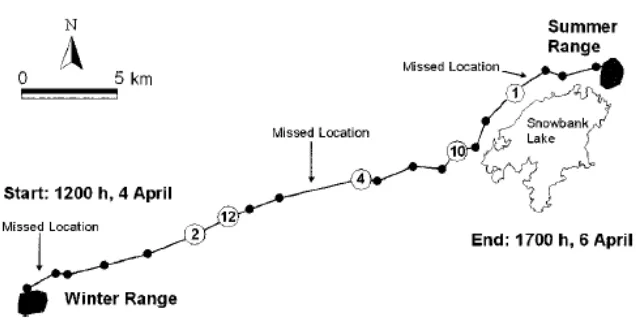
1.5.2.1 Tracking of White-Tailed Deer Migration by Global Positioning System
This thesis wrote by Michael E. Nelson. This discuss in [3] about GPS Tracking
of deer. They used global positioning system (GPS) radio collars on female white-tailed
deer (Odocoileus virginianus) to document details rates of travel and distances traveled
by 8 deer with radio telemetry, knowledge about timing, duration, and route of migration
became possible. This thesis wrote by Michael E. Nelson for Biological Resources
Division, U.S.
[image:23.612.172.492.429.594.2]\
7
1.5.2.1.1 Data loggers
A GPS logger simply
internal memory. Modern GPS loggers in [4] have either a
of the data for further analysis in a computer. Position accuracy state by Michael E.
Nelson in [3] can be improved by using the higher-chiprate P(Y) signal.
1.5.2.1.2 Data pullers
Contrary to a data pusher, that sends the position of the device at regular
intervals
required. Data Pullers in [4] are coming into more common usage in the form of devices
containing a GPS receiver and a cell phone which, when sent a special
reply to the message with their location. This technology is not in widespread use, but an
example of this kind of device is a computer connected to the
1.5.2.1.3 Error Sources
The position calculated by a GPS receiver requires the current time, the position
of the satellite and the measured delay of the received signal. The position accuracy is
primarily dependent on the satellite position and signal delay. To measure the delay, the
receiver compares the bit sequence received from the satellite with an internally