EVALUATION OF REGULATIONS IN DETERMINING
SUITABLE AREAS FOR CHICKEN FARMING
USING GEOGRAPHIC INFORMATION SYSTEM
(CASE STUDY IN SINGKAWANG WEST KALIMANTAN)
AGUS FITRIADI
GRADUATE SCHOOL
BOGOR AGRICULTURAL UNIVERSITY
BOGOR
STATEMENT
I, Agus Fitriadi, hereby stated that this thesis entitled:
EVALUATION OF REGULATIONS IN DETERMINING SUITABLE AREAS FOR CHICKEN FARMING USING GEOGRAPHIC INFORMATION SYSTEM (CASE STUDY IN SINGKAWANG WEST KALIMANTAN)
is result of my own work under the supervision of advisory board during the period of February until July 2011 and that it has not been published before. The content of the thesis has been examined by the advisory board and external examination.
Bogor, August 2011
Agus Fitriadi
ABSTRACT
AGUS FITRIADI. Evaluation of Regulations in Determining Suitable Areas for Chicken Farming Using Geographic Information System (Case Study in Singkawang West Kalimantan). Under the Supervision of NAHROWI and ADE KOMARA MULYANA
Singkawang, West Kalimantan, has the potential for developing chicken farming. Criteria for establishing chicken farming in Indonesia are regulated by a national regulation issued in 1982. The objective of this study was to evaluate the effectiveness of this regulation in determining suitable location for the development of broiler and layer farm in Singkawang. For comparison purposes, some process was carried out using similar regulation issued by the Australia Authority. Geographic Information System (GIS) equipped by spatial analysis with weighted overlay was used in the data processing. Pairwise comparison method was applied to obtain weight of each criterion base on expert judgment. The criteria used in this study were topography, environment, infrastructure, and social and poultry development plan. New formulation by combining criteria in the Indonesian and Australian regulation was introduced. The weight of theses criteria were adjusted accordingly by emphasizing some factor relevant namely water source, feed source and flood risk area The amount of land area suitable for the layer and broiler farm development in Singkawang was wider when applying criteria from Australia regulation than criteria from Indonesia regulation (96.10% or 56, 624 ha versus 70.66% or 43, 104 ha). Equal weighting of the criteria produced wider suitable area. Suitable area for chicken farming was 43,359.96 ha or 71.5 % when applying new formulation. It is concluded that the Indonesia regulation has not been effective to apply in Singkawang. Combining and adjusting the citeria of both regulations in the new formulation produced satisfy results in determining the suitable area.
ABSTRAK
AGUS FITRIADI. Evaluasi Peraturan dalam Menentukan Kesesuaian Area untuk Peternakan Ayam Menggunakan Sistem Informasi Geografis (Studi kasus di Singkawang Kalimantan Barat). Di bawah bimbingan NAHROWI dan ADE KOMARA MULYANA
Singkawang, Kalimantan Barat, memiliki potensi untuk mengembangkan peternakan ayam. Kriteria untuk mendirikan peternakan ayam di Indonesia diatur dengan peraturan nasional yang dikeluarkan pada tahun 1982. Tujuan dari penelitian ini adalah untuk mengevaluasi efektivitas peraturan ini dalam menentukan lokasi yang sesuai untuk pengembangan peternakan ayam pedaging dan ayam petelur di Singkawang. Untuk tujuan perbandingan, beberapa proses dilakukan dengan menggunakan peraturan serupa yang diterbitkan oleh Otoritas Australia. Sistem Informasi Geografis (GIS) yang dilengkapi dengan analisis spasial dengan weighted overlay digunakan dalam pengolahan data. Metode perbandingan berpasangan diterapkan untuk memperoleh bobot masing-masing kriteria dasar berdasarkan penilaian ahli. Kriteria yang digunakan dalam penelitian ini adalah topografi, lingkungan, infrastruktur, social dan rencana pengembangan paternakan unggas. Formulasi baru dibuat dengan menggabungkan kriteria dalam peraturan Indonesia dan Australia. Bobot kriteria telah disesuaikan dengan menekankan beberapa faktor yang relevan yaitu sumber air, sumber pakan dan daerah resiko banjir . Jumlah luas lahan yang sesuai untuk pengembangan peternakan ayam petelur dan ayam pedaging di Singkawang lebih luas ketika menerapkan kriteria pada peraturan Australia dari kriteria pada peraturan Indonesia (96,10% atau 56, 624 ha dibandingkan 70,66% atau 43, 104 ha). Bobot yang sama dari kriteria menghasilkan wilayah yang sesuai yang lebih luas. Wilayah yang sesuai untuk peternakan ayam adalah 43,359.96 ha atau 71,5% ketika menerapkan formulasi baru. Hal ini disimpulkan bahwa bahwa peraturan Indonesia belum efektif untuk diterapkan di Singkawang. Menggabungkan dan menyesuaikan kriteria kedua peraturan dalam formulasi baru yang mendapatkan hasil memuaskan dalam menentukan daerah yang sesuai.
Kata kunci: peternakan ayam , proses gis , peraturan, singkawang
SUMMARY
Singkawang is a municipality in West Kalimantan that has an area around 504 km2 and is known as a center for vegetables and livestock. The city is dominated by poultry products to the needs of other districts. Poultry products can supply to various districts in west Kalimantan, and able to meet the needs for the province. This makes Singkawang as centers of farm products, especially chicken product. Another factor that supports the development of chicken farms in West Kalimantan was due to free from avian influenza (AI) disease. West Kalimantan got certificate from Indonesia Ministry of Agricultural due to free of the disease. Moreover, the development of poultry industry is also supported by organic fertilizer factory in Singkawang.
The purposes of this study were to evaluate the effectiveness of the regulations in establishing the farm and to determine a suitable location for the development of broiler and layer farm in Singkawang, West Kalimantan using Geographic Information System (GIS).
Every country has regulations in determining a suitable area for the development of broiler and layer farms including the countries of Indonesia and Australia. Government of Indonesia has an instrument to regulate the establishment of chicken farming, i.e. SK Ditjen NAK No: 774/ KPTS/DJT/Deptan years 1982 which regulate the establishment of layer and broiler chicken farms. One country that has a design of the chicken farming area is Australia, especially in South Australia. That country also has a regulation to establish a poultry farm in the Guidelines for the Establishment and Operation of Poultry Farms in South Australia. This regulation has many criteria to regulate the establishment and planning of chicken farms.
GIS Application is an automated process that generates a spatially oriented product or result needed by a user. It may include: map update or map production, data query and display, spatial analysis, or other processes that use GIS software and geographic data. This application gives users in the office and in the field effective and easy-to-use ways to access information, answer question, generate products, and support decision-making.
The materials used in this study were digital and analog map, secondary data from relevant agencies in Singkawang, Indonesia’s Regulation (IR) and Australia’s Regulation (AR) of Poultry Farming Establishment and GIS Software. Data requirement that used in this study were : climate factor ( temperature and humidity), feed sources, settlement, water sources, elevation, road access, waste management, poultry farming planning area (IR), and meteorology, future residential, availability of water, topography, road access, poultry management plan, risk of flooding area, soil type, proximity to processor, electricity supply, vegetation (AR).
was to perform an arithmetic process on the pixel input data to produce new pixels as the output data. Weighted overlay was an overlay process that uses weights for each criterion. In the weighted overlay process, the input data is in the form of raster data, which located and stored data using a matrix structure or pixels that make up the grid. The data used consist of several layers of different raster. Weighted Overlay was a technique for applying a common measurement scale of values to diverse and dissiminate inputs to create an integrated analysis
Results from weighted overlay based on expert judgment indicate that: suitable area of topography was 48,257.57 ha or 79.11% (IR) and 55,383.57 ha or 90.7% (AR), environment was 60,070 ha or 98.5% (AR), infra structure was 5,769.56 ha or 9.5 % (AR), all factors was 21,276.04 ha or 51.27 % (IR) and 54,716.11 ha or 89.70% (AR).
Results from weighted overlay based on equal weight indicate that: suitable area of topography was 48,257.57 ha or 79.11% (IR) and 55,383.57 ha or 90.7% (AR), environment was 60,070 ha or 98.5% (AR), infra structure was 12,267.97 ha or 20.04 % (AR), all factors was 43,104.02 ha or 70.66% (IR) and 56,624.44 ha or 96.10 % (AR).
Based on results of the weighted overlay process can showed that equal weight produced a wider suitable area. All of the criteria used to determine suitable areas affected each other. Adding criteria that had wide suitable area produced wider suitable area in weighted result although other criteria were non suitable. This output was related to the process of weighted overlay. .
The amount of land area suitable for the layer and broiler farm development in Singkawang was wider when applying criteria from Australia regulation than criteria from Indonesia regulation (96.10% or 56, 624 ha versus 70.66% or 43, 104 ha). New formulation was the result of the evaluation of GIS processing on both the regulation for determining the location of the poultry farm. Several criteria have higher weight, namely: feed sources, water sources and flooding area. The suitable area were 43,359.96 ha or 71.52%. When applying the new formulation.
It is concluded regulation of establishing chicken farming in Indonesia has not been effective to apply in Singkawang. Suitable location for development of poultry in Singkawang was wider when applying the regulation of Australia than Indonesia.
Copyright @ 2011, Bogor Agricultural University
1. It is prohibited to cite all of part of this thesis without referring to end mentioning the source:
a. Citation only permitted for the sake of education, research, scientific writing, report writing, critical writing or reviewing scientific problem.
b. Citation does not inflict the name and honor of Bogor Agricultural University.
EVALUATION OF REGULATIONS IN DETERMINING
SUITABLE AREAS FOR CHICKEN FARMING
USING GEOGRAPHIC INFORMATION SYSTEM
(CASE STUDY IN SINGKAWANG WEST KALIMANTAN)
AGUS FITRIADI
A thesis submitted for the Degree Master of Science in Information Technology for Natural Resources Management Study Program
GRADUATE SCHOOL
BOGOR AGRICULTURAL UNIVERSITY
BOGOR
Research Title
Student Name
Student ID
Study Program
:
:
:
:
Evaluation of Regulations in Determining Suitable Areas for Chicken Farming Using Geographic Information System (Case Study in Singkawang West Kalimantan).
Agus Fitriadi
G051090071
Master of Science in Information Technology for Natural Resources Management
Approved by, Advisory Board
Supervisor
Prof. Dr. Ir. Nahrowi , M.Sc.
Co-Supervisor
Dr. Ade Komara Mulyana, M.Sc
Endorsed by,
Program Coordinator Dean of the Graduate School
Dr. Ir. Hartrisari Hardjomidjojo, DEA Dr. Ir. Dahrul Syah, M.Sc.Agr
ACKNOWLEDMENTS
Alhamdulillah, Thanks to Almighty of ALLAH SWT, which has given me the opportunity and ability to complete this thesis. The success of this study would not have been possible without various contributions and supports from many people and I will not be able to mention them one by one. Of course, I would like to express my highly appreciation to all of them.
Thanks the author goes to Ministry of Agriculture for giving me the opportunity to continue my studies and providing the financial support for overall expenses during the whole study at Master of Science in Information Technology for Natural Resources Management, Bogor Agricultural University. Beside that, thanks to Prof. Dr. Ir. Nahrowi, M.Sc as my supervisor and Dr. Ir. Ade Komara Mulyana, as co-supervisor for their guidance, supporting and kindly provided me the valuable advice of my research. Moreover, I would like to express my gratitude to the external examiner Dr. Ir. Luki Abdullah, M.Sc,Agr for giving advice and valuable correction to make my thesis acceptable.
Thanks the author goes to several institutions in Singkawang such as Regional Planning Agency (BAPPEDA), Forestry and Agricultural services and Environment Services that facilitated me to obtain field data during my research.
Finally, thank to all staff in MIT secretariat that support our administration, technical and facility, also all MIT lectures who taught me very important knowledge during my study. Also, thank to my colleagues in MIT for helping, supporting and togetherness during my study in MIT program.
Hopefully, this thesis could give positive and good contribution for anyone.
Bogor, August 2011
CURRICULUM VITAE
TABLE OF CONTENTS
Page
TABLE OF CONTENTS ………LIST OF TABLE ………
LIST OF FIGURE ………
LIST OF APPENDIX ………..
xi
xii
xiv
xv
I. INTRODUCTION ………
1.1Background ………
1.2Problem statement ………
1.3Research objective ………
1.4Output ………
1.5Outcome ………
II. LITERATURE REVIEW ……….
2.1Chicken farming ………
2.2Regulation of chicken farming establishment ……… 2.3Geographic information system in poultry ……… 2.4Geographic information system (GIS) processing …………
III.MATERIALS AND METHOD ………..
3.1Time and location ………
3.2Materials ………
3.3Method ………
3.3.1 Pre field work ………
3.3.2 Field data recording ……….
3.3.3 Data processing ………..
3.3.3.1Pairwise comparison method ………. 3.3.3.2Weighted overlay ………
3.4Research flowchart ……… 3.4.1 GIS processing in Indonesia regulation ………… 3.4.2 GIS processing in Australia regulation …………
IV.RESULT AND DISCUSSION ………
4.1Comparison of criteria ………
4.1.1 Topography factor ………
4.1.1.1Road access ………
4.1.1.2Water sources ……….
4.1.1.3Elevation ………
4.1.1.4Temperature ………
4.1.1.5Humidity ………
4.1.1.6Vegetation ………
4.1.1.7Weighted overlay in topography factors..
4.1.2 Environment factor ………
4.1.2.1 Weighted overlay in environment factors 4.1.2.2Environment factors compared chicken
farming ………... 4.1.3 Infra structure factor ………
4.1.3.1Weighted overlay in infrastructure factors 4.1.3.2Infrastructure factors compared chicken
farming………..
4.1.4 Social factor ………
4.2Weighted overlay of all factors ……… 4.3Comparison with existing chicken farming locations ….. 4.4New criteria formulation ………..
V. CONCLUSION AND RECOMMENDATION ……….
5.1Conclusion ………
5.2Recommendation ………
LIST OF TABLE
Page
Table 1 Parameters to regulate chicken farming establishment in Indonesia versus Australia ………
Table 2 Data needed for applying Indonesia regulation….. ……….. Table 3 Data needed for applying the regulation of poultry farms in South
Australia ………
Table 4Pairwise comparison scale………
Table 5Example of a pairwise comparison matrix……… Table 6 Weight each criteria according to expert and equal weight …… Table 7 Quality of water in Singkawang river……… Table 8 Data requirement for new formulation………
12 13
LIST OF FIGURE
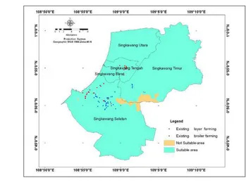
Page Figure 1 Map of Singkawang municipality in West Kalimantan Province …….
Figure 2 The sequence of work ………
Figure 3 Existing chicken farming in Singkawang ………. Figure 4 Research flowchart ……… Figure 5 GIS processing in Indonesia Regulation ……… Figure 6 GIS processing in Australia regulation……….. Figure 7 Suitable areas based on road acces criteria according to Indonesia
regulation (A) and Australia regulation (B) ………. Figure 8 Suitable areas based on water sources criteria according to Indonesia
regulation (A) and Australia regulation(B)………..
Figure 9 Suitable areas based on elevation criteria ………. Figure 10 Temperature data in Singkawang ( 2006 to 2010)…..……….. Figure 11 Humidity data in Singkawang (2006 to 2010)……… Figure 12 Suitable areas based on vegetation criteria according to Australia
regulation. ……….
Figure 13 Suitable areas according to topography factors based on expert and equal weight using Indonesia regulation (A) and Australia regulation (B) ………..
Figure 14 Suitable areas according to environmental factors based on flooding area (A) and soil type (B) using Australia regulation…
Figure 15 Suitable areas according to environmental factors based on expert and equal weight ……… Figure 16 Environment factors compared chicken farming ……… Figure 17 Suitable areas according to infrastructure factors based on
electricity supply(A) and processor (B) using Australia regulation Figure 18 Suitable areas according to infrastructure factors based on expert
judgment (A) and equal weight (B) ……..………
Figure 19 Suitable areas according to infrastructure factors based on expert (A) and equal weight(B) ……….
Figure 20 Suitable area base on social factor according to Indonesia (A) and Australia regulation (B) ………..…………. Figure 21 Density and distribution population in Singkawang ……… Figure 22 Suitable areas according to weight overlay all factors based on
expert judgment using Indonesia regulation (A) and Australia regulation (B) ………. Figure 23 Suitable areas according to weighted overlay all factors base on
equal weight using Indonesia (A) and Australia regulation (B)...
Figure 24 Illustration of calculate grid on weighted overlay ……… Figure 25 Suitable areas all factors based on expert judgment compared
chicken farming using Indonesia (A) and Australia regulation(B) Figure 26 Suitable areas all factors based on equal weight compared chicken
farming using Indonesia(A) and Australia Reguation(B)……….. Figure 27 The wide of suitable area based on expert ………. Figure 28 The wide of suitable area based on equal weight……….. Figure 29 New Formulation based combination of both regulation ………
41
43 44
45
47
48
49
LIST OF APPENDICES
Appendix 1 List of expert ……….……… Appendix 2 Input of Pairwise Comparison Method of All Criteria…………..
Appendix 3 Questionnaire ………...
I.
INTRODUCTION
1.1 Background
Singkawang, one area in West Kalimantan has an area around 504 km2 and
is known as a center for vegetables and livestock. Poultry populations in 2008
were 1,720,800 head of layers, 2,075,000 heads of broiler chickens, 394,549
heads of domestic chicken and 10,794 head of ducks (BPS, 2008). The city has
already self-sufficient in supplying poultry products and even able to supply to
other districts. The poultry products have been distributed to various districts in
west Kalimantan, and able to meet the needs for the province.
Factor that support the development of chicken farms in West Kalimantan
is that this area is free from Avian influenza (AI) disease. The province has got a
certificate “Avian influenza free” from Indonesia ministry of agriculture. The
condition provides an opportunity to farmers or local government to develop a
poultry industry. The success was obtained mainly due to the biosecurity applied
both by local governments and chicken farming industry. The good biosecurity
produced areas that are free from AI diseases. FAO (2008) stated that biosecurity
refers to those measures that should be taken to minimize the risk of incursion of
highly pathogenic avian influenza (HPAI) into individual production units
(bioexclusion) and the risk of outward transmission (biocontainment) and onward
transmission through the production and marketing chain. Another factor that
constributes to development of poultry industry is the high demand of litter or
faecal from poultry industry for organic fertilizer production. The fertilizer is
very useful for vegetable and/or other agriculutural production.
Government of Indonesia has an instrument to regulate the establishment
of chicken farming namely SK Ditjen NAK No 774/ KPTS/DJT/Deptan 1982.
The regulation contained two items, and each items consisted of sub items as
following: (a) Farm locations: distance to the residential, housing design,
availability of water resources and employment (b) Animal health: equipment
and farms environmental. This regulation may be too general to regulate the
regulations in accordance with the conditions at the location of poultry farms
needs to be done.
Australia as developed country, especially South Australia, had a
regulation to establish and operate a poultry farm. The regulation had many
criteria to regulate the establishment and planning of chicken farms. Compared
with the Australian regulation, the Indonesia regulation does not have
management like dead bird disposal, soil type, waste management, electricity
supply, and economic considerations. Therefore, study to compare and combine
these regulations to determine suitable location for chicken farming in
Singkawang was necessary.
Geographic information system (GIS) is a computer-based information
system that enables capture, modeling, storage, retrieval, sharing, manipulation,
analysis and presentation of geographically referenced data. Geospatial or
geographically referenced is a special data that relates to the surface of the earth
(Worboys and Duckham, 2004). Geographic Information System technology is
very helpful to display and present data in map form. Many researches have been
done concerning the use of GIS in determining suitable location for animal waste
location in agricultural fields. However, no data has been reported regarding the
determination of chicken farming sites in Singkawang using Geographic
Information System.
1.2 Problem Statement
Singkawang has the potential to develop and increase the poultry
production in West Kalimantan. Most of the poultry products (meat and eggs)
have been produced from Singkawang and the number of production meets the
demand of animal protein in West Kalimantan. Regional spatial planning has
been used to describe the planning of agricultural development, including poultry
farming in West Kalimantan. But the planning has not explained about the
optimum location for the development of poultry faming. This study expected to
find areas suitable for establishing and developing chicken farms in Singkawang
1.3 Research Objective
The objectives of this research were to compare effectiveness of the
regulation belong to Indonesia and Australia in establishing chicken farms and to
determine suitable areas for chicken farming in the Singkawang.
1.4 Output
The output of this research was suitable areas for chicken farming
development in Singkawang.
1.4Outcome
Results of the study were expected to be a source of information for
decision making to design the chicken farming in Singkawang. This information
could be used by local government to provide input on the spatial plan regarding
II. LITERATURE REVIEW
2.1 Chicken Farming
The condition of poultry farms in Singkawang has prospects for
developed. The number of poultry can be increased considering the availability of
land, the potential of human resources, and high market demand. Currently, the
needs of poultry products (chicken meat and eggs) in West Kalimantan mostly
come from Singkawang. The numbers of poultry in Singkawang were: 1,720,800
head of layers, 2,075,000 heads of broiler chickens, 394,549 heads of domestic
chicken and 10,794 head of ducks (BPS, 2008). Chicken farm development in
Singkawang should be done in a suitable land and spatial planning from local
government.
There were three distinct components of the modern poultry industry,
namely layers (birds producing eggs), broilers (birds producing meat) and breeder
farms. In general, thousands of purpose-bred chickens were delivered to the farm
within hours of hatching. These birds are housed and raised within large, naturally
or mechanically ventilated sheds, having some degree of climate control. Feed is
dispensed to the growing birds from bulk bins via an automatic feeder.
A continuous supply of water is also made available (EPA, 1998). Frederick and
Huda (2011) states the condition of the environment such as bird droppings, soil,
dust, and waste had an important role in spreading salmonella in poultry.
Profitability is directly dependent upon the performance of the hens. Some
technical aspects to be considered such as feeding availability and quality,
management and rearing techniques, and chicken performance. When putting
these techniques into practice, "environmental control" which implies creating an
optimum environment for living and production, is a prerequisite. Therefore, it is
necessary to (1) understand the physiological characteristics of hens, and (2)
create the optimum environment tailored to these characteristics. The ventilation
is not only for supplying the necessary amount of oxygen, but also to provide
optimum environmental conditions with seasonal changes in temperature and
should have been planned before building the farming, as this will affect
production.
Climate is very influential factor on poultry production. Appropriate
location for the poultry farms provides a suitable climate for chicken. Creswell
and Hardjosworo (1979) reported that poultry is "homoeothermic" which must
maintain body temperature within narrow limits if the expected efficiency of the
function call. The problem for poultry in a tropical environment is to prevent the
temperature inside the body rise when the ambient temperature rises. Poultry will
overcome this by slowing the metabolism and appetite. Reduced feed intake can
be partly overcome by manipulation of rations. Temperature level up to 30
degrees Celsius, egg production of laying hens could be maintained normal by
raising levels of nutrition (especially protein). Temperatures above 30 degree
Celsius, egg production usually falls. Donkoh and Atuhene (1988) reported that
environmental temperature affects productivity of poultry and this affects can be
alleviated so that the bird will make optimal productivity. Excessive
environmental temperatures and high relative humidity are main factors that
influences to which birds may be exposed in hot tropical areas.
The establishments of poultry farms need environmental factors
consideration. Site selection and development of poultry farms, has a goal to
reduce adverse impacts on land use. The site chosen should consider the following
factors such as: Availability of water quality, road access for feed and livestock
vehicles, availability of labor, and proximity of feed mill (EPA, 1998).
Settlement conditions affect the development of chicken farms, because a
certain distance should preferably be addressed. Location of poultry farm should
be far from settlements, because it would disrupt the lives of chickens and
societies. Waste from the cage as the odor pollution will disrupt society’s lives.
Life chickens in the farm are also disturbed by human activity.
Location of laying and broiler chicken farms must meet the requirements.
The chicken farm must be located in outside residential areas with a minimum
distance of 250 meters. Altitude must be considered so the waste does not
Land evaluation is a process of assessment of land resources for the
particular purpose, using the approach or methods have been tested. Land
evaluation results will provide information about purpose of land use
Al-Mashreki(2011). The vital task of land evaluation is to identify the levels and
geographical patterns of biophysical constraints and hence, land suitability for a
given purpose. The essence of land suitability evaluation was to compare the
requirements requested by the user types the land to be applied, with the nature or
quality possessed by land. In this way, it will know the potential of land use type
(Widiatmika, 2001). The GIS-based multivariate application for land suitability
assessment base on a public participation has been reported (Tapie et al, 2001).
Determination of land suitability for the chicken farming location is an important
factor in farm management. Allahyari (2011) sated that management of poultry
production, taking into account many factors, such as labor, use of a closed cage,
the technical standard of livestock, including poultry production systems and the
location of the chicken farming.
2.2 Regulation of Chicken Farming Establishment
The government of Indonesia has already a regulation regarding the
establishment of chicken farming business. This study used a reference from
Letter of Ditjennak, number: 774/ KPTS/DJT/Deptan, 1982 about regulation of
establishment of layer and Broiler chicken farms. The regulation contained some
items that must be fulfilled by the farm enterprise, technical, environmental,
human and animal health. In general, it contains about: determining the location
of the sheds, sheds building and equipment, labor, availability of seeds, water and
fodder, animal health and environmental impact. This regulation was made in
attempt to make the chicken farm produces efficiently, does not interfere with
human activities, achieves the chicken and human health and does not damage the
environment.
Every country has its own regulations regarding the establishment of a
chicken farm. The farmers in South Australia follow guidelines in form the
Guidelines for the Establishment and Operation of Poultry Farms in South
poultry farm. EPA (1998) stated that the development of poultry should be
minimized environmental (visual, odor, noise, wastes) impact and impact on
adjoining uses, with allowing future expansion of operations. Poultry
development must be consistent with relevant planning principles and objectives
articulated in local council development plans, maximize bird welfare and
minimize disease risk.
2.3 Geographic Information System in Poultry
GIS technology has been valued for improving communication and
collaboration in decision making, for effectively managing resources and assets,
for enhancing the efficiency of workflows, for improving the accessibility of
information, and generally offering tangible cost savings to organizations both
large and small (Nour, 2011). GIS Application is an automated process that
generates a spatially oriented product or result needed by a user. GIS application
may include: map update or map production, data query and display, spatial
analysis, or other processes that use GIS software and geographic data. This
application gave users in the office and in the field effectively and easy to access
information, answer question, generate products, and support decision-making.
For public sector organization, GIS application was integrated with other system
(e-government, document management, asset management, etc) to support
operations and serve the public (Ogaja, 2010). The application of GIS has provided useful information for human activity and has been widely used in
various sciences, including in the poultry science.
Geographic Information System in Poultry has been reported. Basnet et
al. (2000) developed for the site-specific application of animal waste to
agricultural fields in the Westbrook sub-catchment of the Murray-Darling Basin,
south-east Queensland, and Australia. Sites suitable for animal waste application
were identified using a GIS based weighted linear combination (WLC) model.
This research was important to do for areas that have potential for poultry
industry. The poultry farm waste increased every day and it needs good
management. If it is not addressed properly, it will cause problems in the
GIS has been applied in almost of all study fields, including poultry
science. Johnson et al. (2004) examined to identify cases of infectious
laryngastracheitis in a region of chicken farms in Delmarva Peninsula.
Application of combination GIS and Remote Sensing to determine the location of
a livestock business has also been done by Maris et al (2009). The result helped in
the application of migratory beekeeping in Malaysia. The application of
geographical information systems to display chicken Ranch area in Ciamis
Indonesia has also been done by Priatna et al (2003).
2.4 Geographic Information System (GIS) Processing
Geographical information systems (GIS), are an information system for
capturing, storing, analyzing, managing and presenting data which are spatially
referenced (Thanh, 2009). Processing in Geographic Information System was used
for data processing and display processing results (Prahasta, 2009).
Representation spatial data could be grouped into two parts, namely raster data
and vector data. Raster data model display, placing and storing spatial data with
using a matrix structure or the pixels in the form of grid. Collection of pixels that
draw a spatial object can be called a dataset object. The information contained in
one pixel can be grouped into two sections, the attribute data (information about
the object, e.g. rice fields, gardens, settlements, etc.) and coordinate data
indicating the position of the geometric data. Examples of raster data model is
spatial analysis and modeling especially in environmental nature resources
applications. Vector data model showing, placing and storing spatial data with
using points, lines or polygons and their attributes. These forms are defined by
two-dimensional in Cartesian coordinate system (x, y). A vector representation of
spatial object is an object present as form information geographic that perfect.
Examples of vector data is socio-economic and resources analysis and modeling.
Data are processed by spatial analysis. Some spatial analysis function used
in geographic Information System is: measurement, spatial query and
classification, overlay, buffering, network, and geoprocessing (Longley et al,
The various functions in the process of GIS will be used in this study to
process spatial data. Data of road or river, using a buffer with a distance function
in accordance with the provisions. Overlay function produces new spatial data
from a minimum of two spatial data into two spatial data to be input. Processing
to produce areas suitable for poultry farming, necessary data height of the earth's
surface, soil moisture, and temperature, the spatial analysis function overlay will
be done to the three spatial data (and attribute). This overlay function can also be
applied to raster data model. Similarly to other functions in the GIS processing, in
III.
MATERIAL AND METHOD
3.1 Time and Location
This research was conducted from March to August 2011. Research
location was in Singkawang municipality West Kalimantan Province, which is
geographically located at 0°44'55,85”- 01°01'21,51” (North latitude) and
108°51'47,6”- 109°10'19” (East longitude). The overview of research location can
be seen in Figure 1:
Figure 1 Map of Singkawang municipality in West Kalimantan Province
3.2 Materials
The material used in this study was digital and analog map, secondary data
from relevant agencies in Singkawang (Table 1 and 2), Indonesia’s Regulation
(IR) and Australia’s Regulation (AR) of Poultry Farming Establishment and GIS
Software.
Regulation of Australia was selected in this study because it contains more
numerous and complex criteria in determining the location of poultry farms.
Australia also has a large poultry farm potential appeal in Indonesia. In Australia
the average production of Broiler is 7,500,000 birds per week or 390 million per
annum (Pitt, 2000). It has a good management and integration of many factors in
[image:30.595.86.477.103.730.2]determining the location of poultry farms.
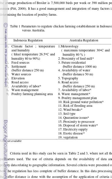
Table 1 Parameters to regulate chicken farming establishment in Indonesia versus Australia.
Indonesia Regulation Australia Regulation
1. Climate factor ; temperature and humidity
( Ideal temperature 26.5°C and humidity 80 to 90%)
2. Feed sources 3. Settlement
(buffer distance 250 m) 4. Water sources
5. Elevation 6. Road access
7. Availability of labor* 8. Waste management
9. Poultry farming planning area
1.Meteorology
( maximum temperature 30°C and humidity 80 % )
2. Proximity of feed mill* 3. Future residential
(buffer distance 1000 m) 4. Availability of water
(buffer distance 50 m) 5. Topography
6. Road access
(buffer distance 250 m) 7. Availability of labor* 8. Waste management* 9. Poultry management plan 10. Risk ground water pollution* 11. Risk of flooding area
12. Wind breaks* 13. Soil type
14. Quarantine issues* 15. Proximity to processor 16. Disposal of storm water* 17. Electricity supply
18. Exotic disease* 19. vegetation *data not available
Criteria used in this study can be seen in Table 2 and 3, where not all the
parameters used. The use of criteria depends on the availability of data and
priority data relating to geographic information. Several criteria were presented on
both the regulation has less complete of buffer distance. In this data processing,
the buffer distance is done with the assumption of the application of criteria in
Table 2 Data needed for applying the Indonesia regulation
No Data Source Format Institution
1 2 3 4 5 6 7 8
Climate :
(Daily temperature and Daily humidity
(2005-2010) Settlement
( Map Scale 1:50.000) Proximity of feed- sources : Water sources
( Map 1 : 50.000) Elevation
(Map Scale 1:50.000) Chicken farming Network of road (Map Scale 1 :50.000) Regional Spatial Plan
Weather data
RTRW Map RTRW Map RTRW Map RTRW Map Database RTRW Map RTRW Map Tabular Digital Map Digital Map Digital Map Digital Map Tabular Digital Map Digital Map Meteorology Station Semelagi Besar Hulu.
Bappeda Singkawang Bappeda Singkawang Bappeda Singkawang Bappeda Singkawang Forestry and Agricultural Agency
Bappeda Singkawang Bappeda Singkawang
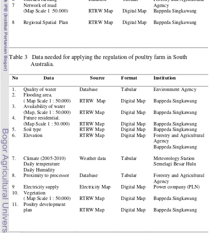
Table 3 Data needed for applying the regulation of poultry farm in South Australia.
No Data Source Format Institution
1. 2. 3. 4. 5. 6. 7. 8. 9 10. 11.
Quality of water Flooding area.
( Map Scale 1 : 50.000) Availability of water (Map, Scale 1 : 50.000) Future residential. (Map Scale 1 : 50.000) Soil type
Elevation
Climate (2005-2010) Daily temperature Daily Humidity Proximity to processor Electricity supply Vegetation
( Map Scale 1 : 50.000) Poultry development plan
Database RTRW Map RTRW Map RTRW Map RTRW Map RTRW Map Weather data Database Electricity Map RTRW Map RTRW Map Tabular Digital Map Digital Map Digital Map Digital Map Digital Map Tabular Tabular Digital Map Digital Map Digital Map Environment Agency Bappeda Singkawang Bappeda Singkawang Bappeda Singkawang Bappeda Singkawang Forestry and Agricultural Agency
Bappeda Singkawang Meteorology Station Semelagi Besar Hulu Forestry and Agricultural Agency
Topography factor consisted of elevation, road access and water sources.
Elevation was the altitude in Singkawang and suitable area at a maximum
elevation of 300 m. Road access given the buffer along a maximum of 500 m (IR)
and 250 (AR). Water sources were the data network of rivers that were given a
maximum of 300 m buffer (IR) and 50 m (AR). Suitable area was located in this
buffer area.
Environment factor consisted of flooding area and soil type. Flooding area
was an area that has a vulnerability to flooding in Singkawang. Soil type was
distribution of soil type that associated with the level of soil fertility. Type of soil
that used in this area was the alluvial, podzolic red-yellow, latosol. This soil type
had good organic content and resistant to erosion.
Infrastructures factor consisted of electricity supply and processor. Electricity
factors, was the existing electricity network in Singkawang. Buffer 100 M was
used in this data. Processor was distributed among poultry slaughtering units and
supply of chicken meat. Buffer 2 km used in this study. Suitable area was located
in this buffer area.
The other factor was social factors and feed sources. Social factors were
derived from the data distribution of settlements in Singkawang. Buffer that used
in residential distance was 250 M for IR and 1000 M for AR. Suitable areas
outside the buffer area.
Feed sources were derived from the data distribution of potency of area to
produce the raw materials of chicken feed, such as maize, cassava, paddy, and
coconut. Suitable areas for the establishment of chicken farm locations was
located are in feed sources areas.
Temperature in the area Singkawang was range from 25 °C to 28 °C, and
humidity was range from 86%. Temperature for chicken farming in the location
were 26.5°C (IR) and maximum 30°C (AR), while level of humidity were 80 to
90% (IR) and maximum 80% (AR). Those data were not processed by GIS since
3.3 Method
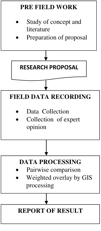
The sequence of work in this research can be seen in figure 2:
[image:33.595.246.418.138.531.2]F
Figure 2 The sequence of work
3.3.1 Pre field work
The main activity in pre-field work was to formulate ideas and concepts
of research, obtained through various studies, as well as literature review and
discussions with faculty mentors. All inputs and improvements to this concept
were implemented in the research.
PRE FIELD WORK
• Study of concept and literature
• Preparation of proposal
RESEARCH PROPOSAL
FIELD DATA RECORDING
• Data Collection
• Collection of expert opinion
DATA PROCESSING
• Pairwise comparison
• Weighted overlay by GIS processing
3.3.2 Field data recording
Data were obtained from recording data in the field. This process was a
very important part of this study, which includes the process of collecting data and
information relating to the research (Figure 2). Data of topography,
infrastructure, environmental factors, social (population), and the master plan for
the Singkawang were collected from local government especially Provincial
Planning Agency (Bappeda) Singkawang (These data can be seen table 2 and 3 ).
Besides that, data from expert in the field of poultry science were taken using
questionnaire to determine the weight of each parameter. The expert were from
academics ( 1 person), livestock government office (2 persons) and professional
farmer (2 persos). In this process involved experts to identify problem causes of
problems, determine the ways solving the problems, and propose alternative
solutions. Expert judgment done through expert surveys, and gained a prominent
place in the comparative study, although validation their assessment results must
be evaluated (Steenbergen, 2007). Method of expert judgment and questionnsire
were used, and the results were calculated based on pairwisecomparison method
(Saaty, 2008). Pairwise camparison was used in determining the weights for the
criteria. This method involved the comparison of the criteria and allows the
comparison of two criteria at a time (Yahaya et al, 2010). The data of pairwise
comparison for each respondent that obtained from quisioner can be seen in
appendix 2. The results of calculations by pairwises comparison, used in the
weighted overlay process (table 6)
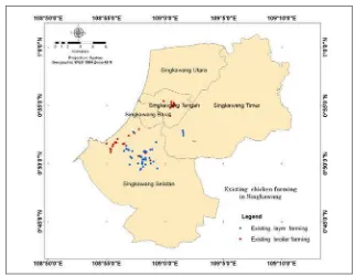
Primary data regarding the existence of chicken farming in Singkawang
was obtained through a survey by Global Positioning System (GPS). Survey data
could be combined between Geographic Information System (GIS) with GPS
(Lagunzad, 2003). Result from survey about existing chicken farming in
Figure 3 Existing chicken farming in Singkawang
Each parameter was displayed on each map and then combined in a GIS
processing, to describe the optimum potential for chicken farms. These results
were compared with an existing poultry farm condition and reviewed regarding
eligibility specific location of the farm. Both regulations were used to compare
and obtain an ideal chicken farming in Singkawang. Data were analyzed using
GIS Software.
3.3.3 Data processing
3.3.3.1 Pairwise Comparison Method (PCM)
Pairwise comparison is a method that used to calculate the expert
assessment of each criteria used in this study. Pairwise comparison method was
developed by Saaty (2008) as part of analytical hierarchy process (AHP). The
comparison between each indicator asked from expert teams, which have
objective to make comparative judgment on the relative importance of each pair
of indicators in term of the criterion they measure.
Therefore numerical values expressing a judgment of the relative
importance (or preference) of one factor against another have to be assigned to
ranging from 1 to 9 which describe the intensity of importance, where by a value
of 1 expresses “equal importance” and a value of 9 is given to those factors
having an “extreme importance” over another factor (Table 4).
Table 4 Pairwise comparison scale
Intensity of Importance
Description
1 Equal importance
3 Moderate importance of one factor over
another
5 Strong or essential importance
7 Very strong importance
9 Extreme importance
2,4,6,8 Intermediate values
Reciprocals Values for inverse comparison
The simple comparison between criteria describe in simple matrix
comparison, which is form in order 3 where three criteria C1, C2, and C3 were
compared against each other. For instance; criterion C1 has been regarded
strongly more important than C3, hence a value of 5 has been assigned to the
corresponding matrix position. The transpose position automatically gets the
reciprocal value, in this case 1/5 which equals 0.2 (Table 5).
Table 5 Example of a pairwise comparison matrix
Criteria C1 C2 C3
C1 1 7 5
C2 0,14 1 0,33
C3 0,2 3 1
The next step of the calculation process, the assigned preference values
were synthesized to determine a ranking of the relevant factors in terms of
Eigen values and eigenvectors of the square preference matrix revealing important
details about pattern in the data matrix are calculated.
Multidiscipline expert with various opinions are important to be examined
one by one for the criteria assessed at the quisionnaire. After that process,
assessments of several experts were combined into one value. Marimin (2008)
states merging values of expert judgment use geometric mean method.
Where; XG = Geometric mean n = Total Respondent
Xi = Judgment value from respondent i
The calculation result from the geometric average method will be used in
the PCM process. The data of pairwise comparison for each respondent that
obtained from quisioner can be seen in appendix 2. The results of calculations by
pairwises comparison, used in the weighted overlay process (table 6)
3.3.3.2 Weighted overlay
Weighted overlay was a spatial analysis that combines at least two layers of
data as input data. This process can be performed on the data in form of vector or
raster data. The principle of the weighted overlay on the raster data was to
perform an arithmetic process on the pixel input data to produce new pixels as the
output data (Prahasta, 2009). Weighted overlay was an overlay process that uses
weights for each criterion (table 6). In the weighted overlay process, the input data
is in the form of raster data and get the result also form of raster. GIS processing
by weighted overlay can be seen figure 5 and 6. In this research, the weighted
overlay was implemented using the weights for each criterion as showed in
Table 6 Weight each criteria according to expert and equal weight
Indonesia Regulation
Criteria Expert*(%) Equal weight(%)
Topography
• Road Access
• Water Sources
• Elevation 19 32 27 41 33 33 33 34
Social 11 33
Feed Sources 70 34
Australia Regulation Topography
• Road Access
• Water Sources
• Elevation • Vegetation 25 23 23 30 24 25 25 25 25 25 Environment
• Flooding Area
• Soil Type
27 65 35 25 50 50 Infra Structure • Electricity • Processor 33 80 20 25 50 50
Social 15 25
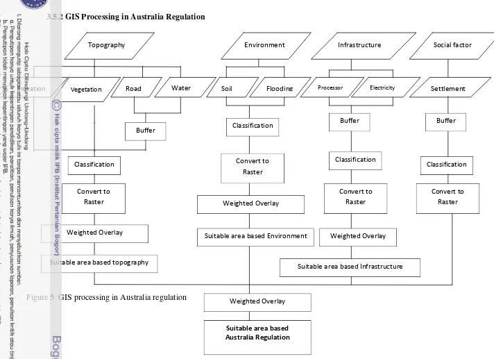
3.4 Research Flowchart
General conceptual of research can be seen in the following flowchart:
Figure 4 Research flowchart
Infrastructure
(Electricity, Processor)
Topography ( elevation, road, river, vegetation,) Environment (Flooding area, ,soil type) Criteria of Chicken Farming Establishment Sites in Indonesia Topography river,elevation, road Social (Settlement ) Regional Spatial Plan GIS Processing
Criteria of Chicken Farming Establishment Sites in Australia.
Social ( Settlement)
Poultry Development Plan
GIS Processing
New Formulation data
GIS Processing
Comparison and Evaluation Existing of
Feed source
Suitable area for
Chicken farming Suitable area for
Chicken farming
Existing of Chicken faming
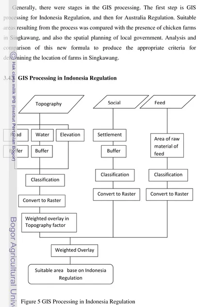
Generally, there were stages in the GIS processing. The first step is GIS
processing for Indonesia Regulation, and then for Australia Regulation. Suitable
areas resulting from the process was compared with the presence of chicken farms
in Singkawang, and also the spatial planning of local government. Analysis and
comparison of this new formula to produce the appropriate criteria for
determining the location of farms in Singkawang.
[image:40.595.78.484.77.709.2]3.4.1 GIS Processing in Indonesia Regulation
Figure 5 GIS Processing in Indonesia Regulation
Suitable area base on Indonesia Regulation
Topography Social
Classification
Convert to Raster
Weighted Overlay
Feed
Road Water Elevation
Classification
Convert to Raster
Weighted overlay in Topography factor Buffer Buffer
Settlement
Area of raw material of feed Buffer
Social factor
Elevation Vegetation Road
Buffer
Classification
Convert to Raster
Weighted Overlay
Water Topography
Suitable area based topography
Environment
Soil Flooding
Classification
Convert to Raster
Weighted Overlay
Suitable area based Environment
Infrastructure
Processor Electricity
Buffer
Classification
Convert to Raster
Weighted Overlay
Suitable area based Infrastructure
Settlement
Buffer
Classification
Convert to Raster
Weighted Overlay
[image:42.842.24.736.40.557.2]Suitable area based Australia Regulation
IV. RESULTS AND DISCUSSION
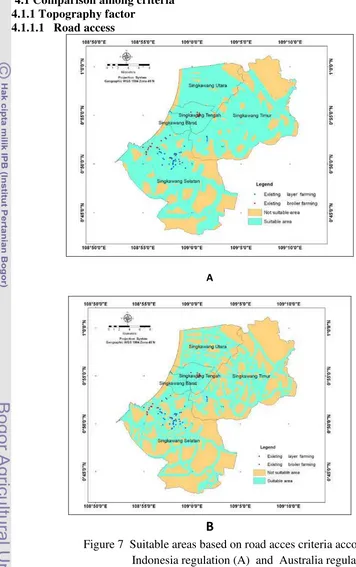
4.1Comparison among criteria4.1.1 Topography factor 4.1.1.1 Road access
A
[image:45.595.102.458.121.688.2]B
Figure 7 Suitable areas based on road acces criteria according to Indonesia regulation (A) and Australia regulation (B)
Figure 7 showed that Indonesia regulation (IR) had a suitable area of
IR. The AR had suitable areas of 28,894.30 ha or 47.36%. All of the farms in the
existing condition were located in suitable areas.
The distribution of chicken farms met the ideal distance recomended. The
condition supported farmers to simplify distribution of feed, production and
marketing of livestock products. Production of chicken farms in Singkawang did
not only supply the needs of consumers in the region, but also supply to other
areas outside Singkawang due to eazy to access the road.
Roads played an important role in the chicken farming. Many activities at
farming required good road access, including the distribution of raw materials and
production facilities, marketing and transportation of workers and other activities.
Establishment of a chicken farm road must meet for various activities.
Ugwu( 2009), roads access must be traversed to reach a commercial poultry farm.This
Facility was used to distribute poultry production inputs like day-old chicks
(DOC), feed, veterinary drugs and others. The condition of processing and
marketing was not difficult to reach regions of production and to send poultry and
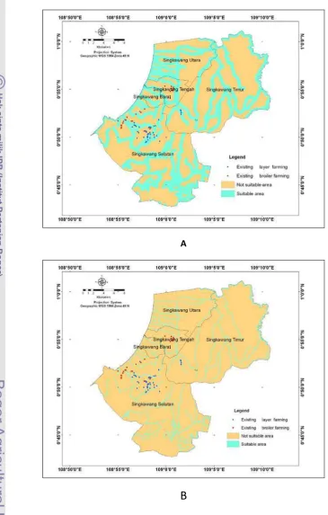
4.1.1.2 Water sources
A
[image:47.595.107.473.100.674.2]B
Figure 8 Suitable areas based on water sources criteria according to Indonesia regulation (A) and Australia regulation (B)
Figure 8 showed that IR had a suitable area of 23,872.6 ha or 39.13%,
farms based on IR were 27 of layer farm (62.7%) and 12 farms of broiler farm (38.7 %),
and its were 14 layer farms (32.5 %) and 6 broiler farms (19.4 %) for AR.
The availability of clean water could not be separated from the location
and maintenance of the chicken. Standard of water to appropriate the needs of
chickens is a main factor to support health, growth and production of poultry.
Water sources must avoid harmful substances, including free from pathogenic
bacteria. Benham (2009)reported that wells or water sources should be placed on
a high area of the location of poultry farms and yard to hide contamination from
waste (faecal or litter). Farm planning should consider the distance between farms
with a water source. Bad management of ground water will contaminate drinking
water supplies in the farm area . Development of water sources must follow the
regulation and requirements, including setting the distance.
Watershed was one source of water used by the farmers in Singkawang.
The watershed was an area of land that is an integral part of the river and its
tributaries, which accommodate, store and transfer water from rainfall to the lake
or the sea naturally. River used in this study was only large rivers that cross
Singkawang (more than 500 km ²) Sambas Regency, and Regency Bengkayang.
Distribution of chicken farms in Singkawang was not far from water
sources mainly from the rivers. There were several farms that are far away from
the river. They use the wells as water sources. Government of Singkawang
preserve water resources for the community of Singkawang to avoid disruption of
existing water quality.
Distribution of layer farms based on access to water source was higher
than those of Broiler chicken Farm. The population of layer chicken was higher,
and therefore the availability and the quality of water must be adequate to the
chicken farm area. Moreover, the maintenance of layer chicken was longer (up to
2 years) and it required more intensive management and facilities to support
production. In contrast, production time of broiler was shorter (only up to 2
months) and the number of population was also low. Although location of broiler
chicken farm was far from the river, some farmers used other water sources, such
as wells
4.1.1.3 Elevation
Figure 9 Suitable areas based on elevation criteria
Based on the criteria of elevation to determine suitable area (Figure 9)
showed that the suitable areas were similar between IR and AR. Both regulation
produced 59.565,1 ha or 97.65% of suitable areas. The distribution of chicken
farms in Singkawang was located at an altitude above 300 m. Almost all regions
in Singkawang were suitable to set areas for a chicken farm. Most areas with
elevation above 300 m were located in mountain areas that are not found
economic activities. This condition made it difficult to access and transport the
chicken.
Altitude affected the temperature level in an area. The higher the place, the
lower the temperature. Pagot (1993) states that the altitude has the same influence
as distance from the equator above 800 m. The variation was in vicinity of 1°C
for every 180 m altitude. Distribution of temperature in Singkawang was
4.1.1.4 Temperature
Temperature data in Singkawang for 5 years are shown in Figure 10 :
Figure 10 Temperature data in Singkawang (2006 to 2010)
Source : Stasiun Meteorologi Laboratorium Pengamatan Penyakit Tanaman Pangan dan Hortikultura Semelagi Besar Hulu .
Temperature distribution in Singkawang was ranged from 25-28 °C
(Figure 10). The temperature met the appropriate level for determining the
location of the chicken farm. DITJENNAK stated that the ideal temperature for
poultry is approximately 26.5 °C.
The ideal temperature will support growth and reproduction of the animals
normally. The chicken will be more efficient to utilize feed because chickens do
not use a lot of energy to overcome the environmental temperature. Chicks try to
keep his body temperature by balancing heat production with heat loss at high
temperature. The high temperature will cause a drop in feed consumption and
resulted in a deficiency of nutrients. Creswell and Hardjosworo (1979) explained,
at very high temperatures poultry lose heat by evaporating even when the
humidity is relatively high. The reason is that the amount of water needed increase
with rising temperatures. At a temperature of 35°C water is lost through the
respiratory. Thus, chicken increase the surface area of the body by extending the
wings and neck feathers and change position to improve air circulation in the
fluctuations in temperature allows the chickens resistant to heat stress during the
day.
4.1.1.5 Humidity
Humidity data in Singkawang for 5 years are shown in Figure 11.
Figure 11 Humidity data in Singkawang (2006 to 2010)
Source : Stasiun Meteorologi Laboratorium Pengamatan Penyakit Tanaman Pangan dan Hortikultura Semelagi Besar Hulu
Regulation of DITJENNAK explained that the maximum moisture for farm
location is 90%. Humidity data in Singkawang were ranged from 80 to 90%. This
condition was suitable for the location of the chicken farming. The ideal humidity
provides a good environment for chicken production. High humidity, more than
90%, has unfavorable effects. High humidity around the enclosure will cause
many adverse factors for poultry, such as increasing soil water neede and reduce
water quality. Increased ground water utilization will cause the development of
parasites (like worms) and bacterial pathogens. . Very humid conditions support
mold growth on feed that can produce toxins in the form of mycotoxins.
Conditions of the cage floor are moist and easy to agglomerate resulting in the
accumulation of ammonia in a cage that can interfere with the respiratory system
in chickens. Ammonia is formed from the breakdown of nitrogenous waste
products in poultry manure (undigested proteins and uric acid) by exogenous
enzymes produced by microorganisms. Factors that exhibit direct impact over
(2005) stated that temperature and moisture as the most important factors
affecting the variability of ammonia in broiler farming. Iyappan, et al. (2011)
reported that combination of climate factors and feeds affected the composition of
chicken Farm Poultry Excreta (PFE). PFE can be used on a variety of useful
activities such as organic fertilizer or fuel and power source. Climate conditions
such as humidity levels can affect the composition of feed given and PFE
humidity, so it can stimulant the activity of microbes. Moreover, at high
evaporation rates, the amount of nutrients consumed tends to decrease.
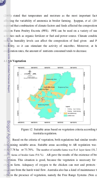
[image:52.595.70.468.28.787.2]4.1.1.6 Vegetation
Figure 12 Suitable areas based on vegetation criteria according to Australia regulation.
Based on the criteria of vegetation, both regulations had similar results on
determining suitable areas. Suitable areas according to AR regulation was
44,987.78 ha or 73.76%. The number of suitable farms was 8 of layer farm (18,.7%)
and 3 farms of broiler farm (9.6 %). AR gave the results of the existence of broad
vegetation. This situation is good, because the vegetation is necessary for the
chicken farm. Adequacy of oxygen to the chicken can met and protects the
enclosure from the harsh wind flow. Australia also has a kind of maintenance that
Systems). This system requires a yard (range) needed in the location of the cage
with enough vegetation (CSIRO, 2002). Chicken in this system has an access to
the outside of the cage.
Application of the free-range system must have vegetation that supports
the existence of environmental farm. However, in Singkawang application of such
cage systems has still not done yet.
4.1.1.7 Weighted Overlay in topography factors
B
Figure 13 Suitable areas according to topography factors based on expert and equal weight using Indonesia regulation (A) and Australia regulation (B)
The topography criteria based on expert and equal weight resulted in a suitable
area of 48,257.54 ha or 79.11% when applying IR, and it was 55,383.57 ha or
90.7 % for AR. The numbers of suitable farms according to AR were 38 layer farms
(88.34 %) and 26 broiler farms (83.80 %). The number of suitable farm was high when
expert and equal weight were applied. This indicated that the topographic factor
in Singkawang has a good effect on chicken farming production. The weights
4.1.2 Environment Factor
A
[image:55.595.117.468.110.691.2]B
Figure 14 showed that suitable area for chicken farm based on criteria of
flooding area was 52,960.09 ha or 86.82% consisting of 34 layer farms (79 %) and
28 broiler farms (90.3 %). Based on soil type criteria, the suitable area was
50.644,87 ha or 83 % corresponding to 40 layer farms (93 %) and all of broiler farms.
Flooding is an important factor to be considered for establishing chicken
farm. The location should be far and protected from flooding area. Regulation of
the establishment of farms in Australia mentioned that location of farms should be
protected from flooding, with an average interval to re-occur for 100 years. This
provision confirms that the location of the farm must be free from flooding area.
Soil type produced wide suitable areas. This factor related to organic
matter element in the soil. Some soils had high organic matter such as latosol,
organosol and red yellow podsolic. This organic material associated with the type
of plants that grow on top. This area was classified as suitable area, because it was
related to crops production for feedstuffs of chicken. Good-quality of organic
matter in soil could produce good quality of feedstuffs.
[image:56.595.59.479.26.745.2]4.1.2.1Weighted overlay in environment factors.
Expert and equal weight application resulted in similar wide areas. It was
60,070.00 ha or 98.5%. Almost all regions in Singkawang were suitable for the
location of the chicken farm. Flooding area could harm for chicken farm location.
Floods could destroy the cages and equipment, making the environment damaged,
and waste disposal problems. Flooding area was important to be considered since
it is happening every year in Singkawang.
[image:57.595.108.473.267.582.2]4.1.2.2 Environment factors compared chicken farming.
Figure 16 Environment factors versus chicken farming
The environmental criteria based on expert and equal weight produced a
suitable area of 1,014 ha or 100% consisting of 27 layer farms (62.80 %) and 3
broiler farms (9.6 %). This result indicated that all areas were suitable for chicken
farming. Environmental factors strongly supported the spatial planning area where
4.1.3 Infrastructure factor
A
[image:58.595.89.441.95.657.2]B
Figure 17 Suitable areas according to infrastructure factors based on electricity supply (A) and processor (B) using Australia regulation
The infrastructure criteria consist of electricity supply and processor in
ha or 9.47 % composing of 38 layer farms (88.4 %) and 11.6% broiler farms.
While based on processor criteria, it was 9,624.48 ha or 15.77 % consisting of 7
layer farms (16.27 %) and 28 broiler farms (90.3%). The availability of
electricity only got small suitable area. Singkawang has a wide area that does not
have electricity facilities. However, many farms in the existing condition located
in the area having an electrical network. Electricity has been used in a chicken
farm for a variety of activities. CSIRO (2003) reported that chickens are caged
without access to the daytime activities. They should be given lighting more on
maintenance periods at least 8 hours per day. Regulation of the establishment of
the cage in Australia explained that the electricity supply must be met before the
establishment of a chicken farm.
Processor is a chicken slaughtering unit used as a poultry abattoir, sales
and distribution of chicken production. Broiler farming located in the area was
suitable from this factor. This is in accordance with the conditions of chicken
slaughtering in Singkawang. Processor served many products from broiler chicken
farm and produced meat that is not far from the location of the broiler farms.
Chickens that will be sold and transported should be protected from stress. It
4.1.3.1Weighted overlay in infrastructure factors.
A
[image:60.595.93.446.92.691.2]B
Figure 18 Suitable areas according to infrastructure factors based on expert judgment (A) and equal weight (B)
The infrastructure