Toward Regional Rainfall Threshold For Landslide
Occurrence In Yogyakarta And Central Of Java
By: Agus Setyo Muntohar*
Abstract: Landslides are one of the most widespread natural hazards in the world, responsible for thousands of deaths and billions of dollars in property damage every year. However, predicting landslide potential at a global scale using real-time monitoring is very difficult and expensive in terms of time and money. This is especially true in developing countries where expensive ground observation networks are prohibitive and in mountainous areas where access is minimize. This paper studies the relationship between rainfall and landslides event in Yogyakarta and Central of Java area. Landslides events and the triggering rainfall are collected from Kalibawang (Yogyakarta), Kebumen, Karanganyar, Banjarnegara (Central of Java). The landslide type at those locations is identified as shallow, deep-seated, and debris flow. Loss and damages of settlement and people was reported during the landslide occurrence. Based on the data collection from those landslide occurrences, an empirical rainfall threshold was determined based on intensity-duration (ID) and cumulative-intensity (EI) relationship. The threshold curve was obtained from the rainfall data using an objective statistical technique. The proposed ID and EI curves are also compared with the global existing rainfall threshold. The ID curve for the studied region is higher than the global rainfall threshold that proposed by several investigators. However, new regional rainfall thresholds for Yogyakarta and Central of Java can be used in a regional operational landslide warning system based on local or regional precipitation measurements where local and regional thresholds are not available.
Keywords: landslides, rainfall intensity, duration, accumulated rainfall, rainfall-threshold.
1.
INTRODUCTIONIt has been noted that landslides may occur in some slopes, but many other slopes is remaining stable under a similar severe triggering condition such as typhoon and earthquake. Some landslides occurred in natural slopes and some other happened in engineered slopes with counter measured protection. So, it is of interest to find out why does a landslide happen but others do not. If landslide will happen, where and when it will happen? In other words, "why, where, and when" (3W) will a slope failure occur are the key issues for the landslide research.
where expensive ground observation networks are prohibitive and in mountainous areas where access is minimize. This paper studies the relationship between rainfall and landslides event in Yogyakarta and Central of Java area.
Generally speaking, 'rainfall threshold’ can be defined as the critical level (minimum or maximum) of rainfall values for a process to take place Reichenbach et al. 1998. Rainfall thresholds can be divided in global, regional and local thresholds. A global empirical threshold is obtained by using the available data from different regions world-wide. The meaning of these thresholds consists in the possibility of having a general threshold which is independent of local conditions and of typical rainfall patterns. The easiest way to define a global threshold consists in tracing a lower limit line embracing all the recorded rainfall conditions that resulted in landslides. Regional thresholds are defined by grouping data from regions of similar meteorological, geological and physiographic characteristics. A local rainfall threshold explicitly or implicitly considers the local climatic regime and geomorphologic setting. Landslide-triggering rainfall thresholds separate events that resulted from those which failed to triggered landslides. Rainfall thresholds can be defined by means empirical based model, physical-process based model, and statistic-based model. In this paper, empirical-based model is analyzed to obtain rainfall threshold. Two empirical models are established that is rainfall intensity – duration relationship and rainfall intensity - accumulated rainfall relationship.
2.
METHOD AND ANALYSIS2.1 Empirical – based rainfall threshold
In this study, the threshold is defined as lower boundary of rainfall for a landslide to occur. Thus, an empirical-based model is applied to define the value. Empirical thresholds are obtained studying rainfall conditions, which resulted in slope failures. Most of the proposed thresholds perform reasonably well in the region where they were developed, but can not be exported to neighboring areas. Also, their temporal accuracy remains largely untested Crozier (1999). Most commonly, the empirical thresholds correlate rainfall intensity and duration (I-D curve) and cumulative precipitation during an event. The common expression for ID threshold has the general form:
b
I c aD (1)
where I is rainfall intensity, D is rainfall duration, and a, b and c are empirical parameters. The parameters can be determined from the best-fit of the relationship. When c = 0 Eq. (1) is a simple power law.
In general, slope failure is as result of combination both rainfall intensity and accumulated rainfall. Some investigators have linked measures of the cumulative event rainfall to the average rainfall intensity, obtaining event-intensity (EI). Onodera et. al (1974), who were probably the first to propose quantitative rainfall thresholds for the initiation of landslides, further proposed a set of thresholds linking the hourly event intensity to the ratio between the average and the maximum rainfall intensity per hour.
Using the similar concept of power law and rainfall intensity – accumulated rainfall record, a threshold can be also devised between rainfall intensity and accumulated rainfall.
p
I m nR (2)
2.2 Landslides and rainfall Record
2.2.1 Kalibawang, Kulon Progo, Yogyakarta province
Kalibawang is the most active landslides area in Yogyakarta during rainy-session in December – March. Kalibawang is located 20 km west of Yogyakarta province. The landslide area is mostly occurred at Kalibawang channel which the area is approximate 75 km2. The channel is situated at the foot of Kulon Progo mountain hill and has been disrupted by some landslides in the rainy season. This channel is vital for the agriculture of downstream side area. During 2001 – 2004, there were five landslide events near the Kalibawang channel. The triggering rainfall data is taken from Kalibawang station where the closest station point to the research area is presented in Table 1. Most the landslide events are characterized by the successive movement of sliding with gentle inclination angle (Kyi et al. 2007). The soil covering slope is predominantly clayey soil. When dry session, fissured on slope surface appear, and as consequence rainfall increased the pore water pressure in the slope during the wet session
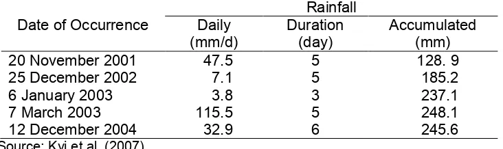
Table 1 The rainfall – triggering landslides at Kalibawang from 2001 – 2004
Date of Occurrence
Rainfall Daily
(mm/d)
Duration (day)
Accumulated (mm)
20 November 2001 47.5 5 128. 9
25 December 2002 7.1 5 185.2
6 January 2003 3.8 3 237.1
7 March 2003 115.5 5 248.1
12 December 2004 32.9 6 245.6
Source: Kyi et al. (2007)
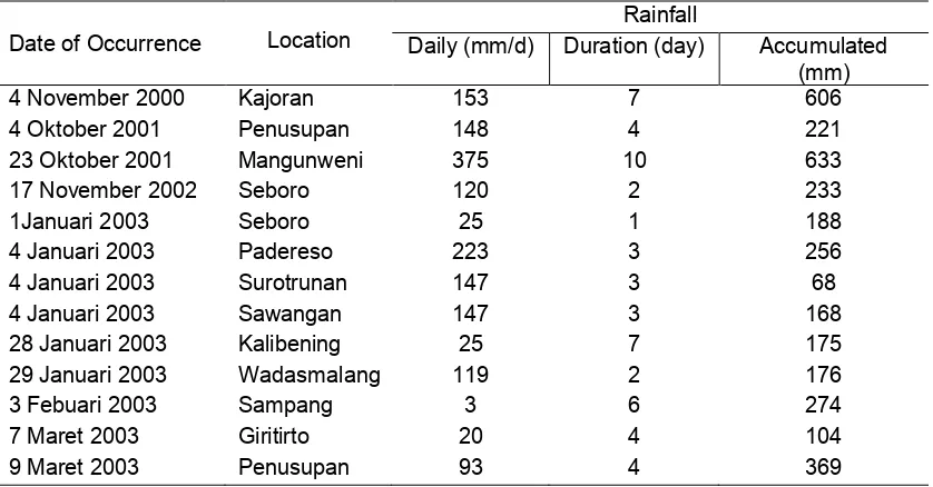
2.2.2 Kebumen, Central of Java province
Landslide event at Kebumen, generally, was attributed by human activities near the hill slope such as land-use conversion and deforesting. Mostly, the land-use was converted improperly. The hill slope was converted to seasonal outgrowth. Agricultural was activated on the hill slope with the inclination angle greater than 20o. As a result, the slopes are susceptible to the landslide-induced rainfall although it is gently slope. A study carried out by Sukresno et al. (2004) reported that the triggering rainfall in several landslide occurrence in Kebumen is about 131 mm/day in average. Table 3 presents the landslides events and rainfall records in Kebumen. The slopes were predominantly covered with high-plasticity clayey-silt soils. The soil is rest on breccias and andesitic formation.
2.2.3 Mogol, Karanganyar, Central of Java province
It is interesting to study landslide that occur at Mogol village. The village is located at hillside of Tawangmangu, Karanganyar district, Central of Java province. The
Mogol’s landslide was reported to occur in daybreak of 26 December 2007. The
194 mm. The accumulated rainfall from 24 – 26 December 2007 is approximate 203 mm. The detail of rainfall record from several rainfall stations around the hazard area is presented in Table 3.
Table 2 The rainfall and landslide records at Kebumen from 2000-2003
Date of Occurrence Location
Rainfall
Daily (mm/d) Duration (day) Accumulated (mm)
4 November 2000 Kajoran 153 7 606
4 Oktober 2001 Penusupan 148 4 221
23 Oktober 2001 Mangunweni 375 10 633
17 November 2002 Seboro 120 2 233
1Januari 2003 Seboro 25 1 188
4 Januari 2003 Padereso 223 3 256
4 Januari 2003 Surotrunan 147 3 68
4 Januari 2003 Sawangan 147 3 168
28 Januari 2003 Kalibening 25 7 175
29 Januari 2003 Wadasmalang 119 2 176
3 Febuari 2003 Sampang 3 6 274
7 Maret 2003 Giritirto 20 4 104
9 Maret 2003 Penusupan 93 4 369
Source: Sukresno et al. (2004)
Table 3 Rainfall record at near station on 22-28 December 2007
Station Location Date (December 2007) Cumulative
22 23 24 25 26 27 28 (mm)
Waduk Nawangan 16 16 11 147 54 4 28 276
Tawangmangu 0 0 8 194 1 56 44 303
Palur 1 0 1 102 2 95 37 238
Pabelan 0 0 2 133 5 111 25 276
Source: Stasiun Klimatologi Semarang dan Balai Sungai Surakarta
3.
RESULTS AND DISCUSSIONS3.1 Proposal of Rainfall Thresholds
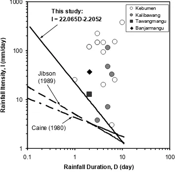
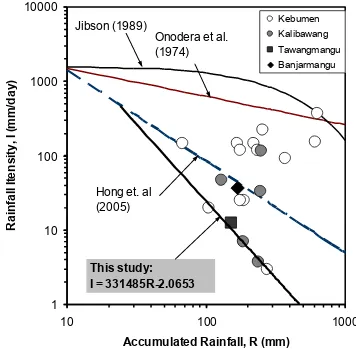
Generally, empirical thresholds are presented as lower limit curves separating areas with specific combinations of values of plotted variables. The number of the triggered slope failures (i.e., single vs. multiple or few vs. numerous) can also be considered. More rarely, the rainfall conditions that did not result in landslides are considered to better constraint an empirical rainfall threshold. Since, the threshold is defined empirically, so, the equations proposed may vary from one location to others. Based on the landslide events and rainfall record from the observed location, rainfall intensity and duration (ID curve) correlation is shown as in Figure 1. And, cumulative event rainfall and intensity (EI curve) is shown in Figure 2. The lower boundary of the triggering-rainfall is expresses as given in Equation (3) and (4) respectively for the ID and EI relationship
2.2052
22.065
I
D
(3)2.0653 331486
[image:5.595.124.488.421.492.2]where I: mean rainfall intensity (mm/d), D: antecedent rainfall period (day), and R: cumulative rainfall (mm). The threshold given by Equation (3) and (4) is the lower limit of rainfall-triggered landslides. Any values upper the equation line is categorized as triggering rainfall. In this case, the slope is probably will fail under the rainfall.
1 10 100 1000
0.1 1 10 100
Rainfall Duration, D (day)
R
a
in
fa
ll
I
te
n
s
it
y
,
I
(m
m
/d
a
y
)
Kebumen Kalibawang Tawangmangu Banjarmangu
Caine (1980) Jibson (1989)
This study:
I = 22.065D-2.2052
Figure 1. Intensity – Duration (ID) Curve for Rainfall threshold triggered landslides at Kulon Progo, Kebumen, dan Karanganyar.
1
10
100
1000
10000
10
100
1000
Accumulated Rainfall, R (mm)
R
a
in
fa
ll
I
te
n
s
it
y
,
I
(m
m
/d
a
y
)
Kebumen Kalibawang
Tawangmangu Banjarmangu
This study:
I = 331485R-2.0653
Hong et. al
(2005)
Onodera et al.
(1974)
Jibson (1989)
Figure 2. Intensity – Accumulated Rainfall curve (EI) for Rainfall threshold triggered landslides at Kulon Progo, Kebumen, and Karanganyar.
To overcome the disadvantage of ID curve, the EI curve in Figure 2 plots intensity and cumulative rainfall induce landslides. It is only a few researches to correlate the intensity and cumulative rainfall. At least, there are 20 empirical thresholds of EI curve which is developed by eight researches around the world Guzzetti et al. (2007). The proposed empirical threshold in this study gives lower boundary of rainfall if comparing with the other empirical thresholds that proposed by Onodera et al. (1974), Jibson (1989) and Hong et al. (2005). Guzzetti et al. (2007) reviewed that when using cumulative event rainfall measurements to predict landslide occurrence, a key difficulty is the definition of the period over which to accumulate the precipitation. Research carried out by Aleotti (2004) did not find a correlation between the critical and the cumulative rainfall and the occurrence of landslides in the Piedmont region, NW-Italy. However, combination of the empirical threshold with real-time rainfall monitoring will result significant estimation for landslide early warning system (LEWS) as suggested by Keefer et al. (1987).
4.
CONCLUDING REMARKSReichenbach et al. (1998) is that thresholds inevitably represent a simplification of the relationship between rainfall and landslide occurrence. Rainfall is not the direct cause of failures which, in fact, are caused by the build-up of high pore water pressure in the slope, a phenomenon that is also related to hydraulic, physical and mechanical properties of terrain and to other environmental factors like slope, vegetation cover, and climatic characteristics of the area.
The ID and EI threshold in this study is new regional rainfall thresholds for Yogyakarta and Central of Java. Comparison with other thresholds pointed out the difference with those proposed by Onodera et al. (1974), Caine (1980), Jibson (1989), and Hong et al. (2005) for global thresholds. The empirical thresholds may be used in a regional operational landslide warning system based on local or regional precipitation measurements where local and regional thresholds are not available. The thresholds could be further refined by introducing other case studies in the analysis.
5.
REFERENCESAleotti, P., 2004, "A warning system for rainfall-induced shallow failures." Engineering
Geology, Vol. 73, pp. 247–265.
Caine, N., 1980, "The Rainfall Intensity-Duration Control of Shallow Landslides and Debris Flows." Geografiska Annaler. Series A, Physical Geography, Vol. 62(1-2), pp. 23-27.
Campbell, R. H. (1975). Soil slips, debris flows, and rainstorms in the Santa Monica Mountains and vicinity, southern California. US Geological Survey Professional Paper. Washington DC, US Geological Survey. 851: 51.
Crozier, M. J., 1999, "Prediction of rainfall-triggered landslides: a test of the antecedent water status model." Earth Surface Processes and Landforms, Vol. 24(9), pp. 825-833.
Guzzetti, F., Peruccacci, S., Rossi, M. and Stark, C. P., 2007, "Rainfall thresholds for the initiation of landslides in central and southern Europe." Meteorology and Atmospheric
Physics, Vol. 98(3-4), pp. 239-267.
Hong, Y., Hiura, H., Shino, K., Sassa, K., Suemine, A., Fukuoka, H. and Wang, G., 2005, "The influence of intense rainfall on the activity of large-scale crystalline schist landslides in Shikoku Island, Japan." Landslides, Vol. 2(2), pp. 97-105.
Jibson, R. W., 1989, Debris flow in southern Puerto Rico.In Schultz, A. P. and Jibson, R. W. (Eds). "Landslide Processes of the Eastern United States and Puerto Rico". Boulder, Geological Society of America. Special Paper 236, pp. 29-55.
Keefer, D. K., Wilson, R. C., Mark, R. K., Brabb, E. E., Brown, W. M., Ellen, S. D., Harp, E. L., Wieczorek, G. F., Alger, C. S. and Zatkin, R. S., 1987, "Real-Time Landslide Warning During Heavy Rainfall." Science, Vol. 238(11), pp. 921-925.
Kyi, S. S., Nguyen, T. D., Aoki, K., Mito, Y., Suryolelono, K. B., Karnawati, D. and Pramuwijoyo, S., 2007, "Landslide risk microzonation by using multivariate statistical analysis and GIS." International Journal of the Japanse Committee for Rock
Mechanics, Vol. 3(1), pp. 7-15.
Onodera, T., Yoshinaka, R. and Kazama, H. (1974). Slope failures caused by heavy rainfall in Japan. Second International Congress of the International Association of
Engineering Geology. Sao Paulo. II: pp 1-10.
Sukresno, Adi, R. N. and Wardoyo (2004). Hubungan Sifat-Sifat Hujan Terhadap Kepekaan Tanah Longsor di Kebumen. Prosiding Ekspose BP2TPDAS-IBB Surakarta. Kebumen: 95-101.
Wieczorek, G. F. (1996). Landslide triggering mechanisms. Landslides: Investigation and
Mitigation. Turner and Shuster, Transportation Research Board-National Research
Council. 247: 76– 90.
Wilson, R. C., 1989, Rainstorms, pore pressures, and debris flows: a theoretical framework.In Morton, D. M. and Sadler, P. M. (Eds). "Landslides in a semi-arid
environment". California, Publications of the Inland Geological Society. Vol. 2, pp.