UNIVERSITI TEKNIKAL MALAYSIA MELAKA
VEHICLE MONITORING AND TRACKING SYSTEM
USING GSM
This report submitted in accordance with requirement of the Universiti Teknikal Malaysia Melaka ( UTeM ) for the Bachelor's Degree in Electrical Engineering Technology ( Industrial
Automation and Robotics ) ( Hons.)
By
RAJA MUHAMMAD ARIFF BIN RAJA IBRAHIM
B071210216
910601-06-5655
BORANG PENGESAHAN STATUS LAPORAN PROJEK SARJANA MUDA
TAJUK: VEHICLE MONITORING
SESI PENGAJIAN: 201
Saya RAJA MUHAMMAD ARIFF
mengaku membenarkan Laporan PSM ini disimpan di Perpustakaan Universiti Teknikal Malaysia Melaka (UTeM) dengan syarat
1. Laporan PSM adalah hak milik Universiti Teknikal Malaysia Melaka dan penulis. 2. Perpustakaan Universiti Teknikal Malaysia Melaka dibenarkan membuat salinan
untuk tujuan pengajian sahaja dengan izin penulis. 3. Perpustakaan dibenarkan membuat salinan la
pertukaran antara institusi pengajian tinggi.
** Jika Laporan PSM ini SULIT atau TERHAD, sila lampirkan surat daripada pihak berkuasa/organisasi berkenaan dengan menyatakan
SULIT atau TERHAD.
UNIVERSITI TEKNIKAL MALAYSIA MELAKA
BORANG PENGESAHAN STATUS LAPORAN PROJEK SARJANA MUDA
VEHICLE MONITORING AND TRACKING SYSTEM USING GSM 2015/16 Semester 1
RAJA MUHAMMAD ARIFF BIN RAJA IBRAHIM
mengaku membenarkan Laporan PSM ini disimpan di Perpustakaan Universiti Teknikal Malaysia Melaka (UTeM) dengan syarat-syarat kegunaan seperti
Laporan PSM adalah hak milik Universiti Teknikal Malaysia Melaka dan penulis. Perpustakaan Universiti Teknikal Malaysia Melaka dibenarkan membuat salinan untuk tujuan pengajian sahaja dengan izin penulis.
Perpustakaan dibenarkan membuat salinan laporan PSM ini sebagai bahan pertukaran antara institusi pengajian tinggi.
)
TIDAK TERHAD
(Mengandungi maklumat yang berdarjah keselamatan atau kepentingan Malaysia sebagaimana yang termaktub dalam AKTA RAHSIA RASMI 1972)
(Mengandungi maklumat TERHAD yang telah ditentukan oleh organisasi/badan di mana penyelidikan dijalankan)
_____________________
** Jika Laporan PSM ini SULIT atau TERHAD, sila lampirkan surat daripada pihak berkuasa/organisasi berkenaan dengan menyatakan sekali sebab dan tempoh laporan PSM ini perlu dikelaskan sebagai
UNIVERSITI TEKNIKAL MALAYSIA MELAKA
BORANG PENGESAHAN STATUS LAPORAN PROJEK SARJANA MUDA
AND TRACKING SYSTEM USING GSM
mengaku membenarkan Laporan PSM ini disimpan di Perpustakaan Universiti syarat kegunaan seperti berikut: Laporan PSM adalah hak milik Universiti Teknikal Malaysia Melaka dan penulis. Perpustakaan Universiti Teknikal Malaysia Melaka dibenarkan membuat salinan
poran PSM ini sebagai bahan
yang berdarjah keselamatan atau kepentingan Malaysia sebagaimana yang termaktub dalam AKTA RAHSIA RASMI 1972)
(Mengandungi maklumat TERHAD yang telah ditentukan oleh organisasi/badan di mana penyelidikan dijalankan)
Disahkan oleh:
_____________________
iii
DECLARATION
I hereby, declared this report entitled Vehicle Monitoring And Tracking System Using GSM
is the results of my own research except as cited in references.
Signature :………
Name : ………
iv
APPROVAL
This report is submitted to the Faculty of Engineering Technology of UTeM as a partial fulfillment of the requirements for the degree of Bachelor in Electrical Engineering Technology ( Automation Industry & Robotic) with Honours. The member of the supervisory is as follow:
v
ABSTRACT
vi
ABSTRAK
Sistem pengesanan kenderaan menjadi semakin penting di bandar-bandar besar dan
ia lebih selamat berbanding sistem lain. Pada masa kini kecurian kenderaan semakin
meningkat dengan pesat, dengan ini kita boleh mempunyai kawalan yang baik di
dalamnya. Ini akan menyebabkan, kehilangan banyak wang dan kereta. GPS adalah
salah satu teknologi yang digunakan dalam sejumlah besar aplikasi hari ini. Salah
satu aplikasi menjejaki kenderaan anda dan memastikan pemantauan berkala ke atas
mereka. Sistem pengesanan boleh memberitahu lokasi dan laluan yang dilalui oleh
kenderaan, dan maklumat yang boleh dilihat dari mana-mana lokasi yang jauh lain.
Ia juga termasuk aplikasi web yang menyediakan anda lokasi sebenar sasaran. Sistem
ini membolehkan kita untuk mengesan sasaran dalam mana-mana keadaan cuaca.
Objektif utama adalah untuk mereka bentuk satu sistem yang boleh dengan mudah
dipasang dan menyediakan platform untuk meningkatkan lagi. Sistem ini
menggunakan GPS dan GSM teknologi. Projek ini termasuk sebahagian perkakasan
yang terdiri daripada GPS, GSM, ATmega mikropengawal, dan sebahagian perisian
digunakan untuk antara muka semua keputusan yang dikehendaki modul. Ianya
dijangka mampu untuk membangunkan prototaip pemantauan kenderaan dan sistem
pengesanan menggunakan GPS. Sistem pengesanan yang dapat memberi tahu lokasi
dan laluan yang dilalui oleh kenderaan dan untuk membangunkan sistem
vii
DEDICATION
To my beloved parents To my kind lecturers And not forgetting to all friends
For their
viii
ACKNOWLEDGEMENT
In completing this project, I have received a lot of helps from my supervisor, lecturers, researchers and family members and fellow friends.
Firstly, I want to give my upmost thanks to my supervisor, Miss Suziana binti Ahmad who gave me an opportunity to do this project for guiding and assisting me through the completion of this project. Without her guidance and persistent help, this project would not have been successful.
I would like to express deepest appreciation to my parents in supporting me mentally and financially, for their encouragements and supports.
Secondly, it is also my duty to record my thankfulness to my fellow friends that gave advice at some points and lent me a hand in completing the project. Also to a friend that offered this private space for field test and analysis of the prototype.
ix
CHAPTER 2 : LITERATURE REVIEW AND PROJECT BACKGROUND 5
2.1 Wireless Data Communication 5
2.1.1 GSM Modem 5
2.1.2 Bluetooth 6
2.1.3 Wireless Infrared Communication 8
2.2 Global Positioning System (GPS) 9
2.2.1 GPS Data Loggers 10
2.2.2 GPS Data Pusher 11
x
2.3 Microcontroller 13
2.3.1 Arduino Mega 2560 13
2.3.2 Raspberry 14
2.3.3 Beaglebone Board 15
2.3.4 Comparison Between Different Microcontroller 15
2.4 Ultrasonic Sensor 17
CHAPTER 3 : METHODOLOGY 18
3.1 Overview of the project 18
3.2 Study On Vehicle Tracking And Monitoring System Using GSM 19
3.3 Electrical Development 19
3.3.1 Arduino Uno R3 ( Atmega 328) 20
3.3.2 Piezoelectric Buzzer 21
3.3.3 GSM ( Global System For Mobile Communication ) 22
3.3.4 4 Channel Relay 23
3.3.5 Global Positioning System (GPS) 24
3.3.6 Ultrasonic Sensor 25
3.7.3 Sensitivity Of Equipment Testing 34 3.7.4 Equipment Position in Vehicle Testing 36
CHAPTER 4 : RESULT AND DISCUSSION 38
4.1 Test for The Functionality of Overall System 38
4.1.1 Result and Analysis 38
xi
4.2.1 Result and Analysis 41
4.3 Testing for Sensitivity of Equipment 43
4.3.1 Result and Analysis 44
4.3.1.1 Ultrasonic Sensor Result and Analysis 44
4.3.1.2 GPS Result and Analysis 45
4.4 Testing the Position of Equipment in Vehicle 47
4.4.1 Result and Analysis 47
4.5 Discussion 48
CHAPTER 5 CONCLUSION AND RECOMMENDATION 49
5.1 Conclusion 49
5.2 Recommendation 50
REFERENCES 51
xii
LIST OF FIGURE
Figure 2.1 GSM Modem 5
Figure 2.2 Bluetooth Device 6
Figure 2.3 Infrared 8
Figure 2.4 Basic Wireless Infrared Communication 9
Figure 2.5 GPS System Overview 9
Figure 2.6 GPS Data Loggers 10
Figure 2.7 Data Logger System Overview 10
Figure 2.8 GPS Data Pusher 11
Figure 2.9 GPS Data Puller 12
Figure 2.10 Arduino Uno 13
Figure 2.11 Raspberry 14
Figure 2.12 Beaglebone Board 15
Figure 2.13 Ultrasonic Sensor 17
Figure 2.14 PIC16F877A 16
Figure 3.1: Flow of the project 18
Figure 3.2: Arduino Uno R3 20
Figure 3.3: Structures of Piezoelecctric Buzzer 21
Figure 3.4: GSM modem 22
Figure 3.5: 4 Channel Relay Pin Configurations 23 Figure 3.6: Global Positioning System soldering process 24
Figure 3.7: Ultrasonic Sensor 25
Figure 3.8: Connection of Component 26
xiii
Figure 4.1: Open Lot Parking testing 41
Figure 4.2: Rooftop Parking Testing 42
Figure 4.3: Basement Parking Testing 42
Figure 4.4: Vehicle into building 43
xiv
LIST OF TABLE
Table 2.1 : Comparison Between Different Microcontroller 16 Based Platform.(Pooja Desai et al,2014)
Table 3.1 : Specification of Arduino Uno 20
Table 3.2 : Piezoelectric Buzzer Connection to Arduino Uno 21 Table 3.3 : Pin Connection of GSM to Arduino Uno 22 Table 3.4 : Connection between 4 channel relay and Arduino Uno 23 Table 3.5 : Pin Connection Between GPS and Arduino Uno 24 Table 3.6 : Connection between Ultrasonic Sensor and Arduino Uno 25
Table 3.7 : Table for Data Testing 32
Table 3.8 : Table Of Indoor and Outdoor Testing 33 Table 3.9 : Table Sensitivity of Ultrasonic Sensor Testing 34 Table 3.10 : Place for Sensitivity's of GPS Testing 35 Table 3.11 : Equipment Position in Vehicle 36
Table 4.1 : Data Testing Result 38
Table 4.2 : Process of the System 39
Table 4.3 : Result Of Indoor and Outdoor Testing 41 Table 4.4 : Result of Ultrasonic Sensor Time Testing 44 Table 4.5 : Result Sensitivity of GPS Testing 46 Table 4.6 : Result of Equipment Position in Vehicle Testing 47
xv
LIST OF SYMBOLS AND ABBREVIATIONS
GPS = Global Positioning System GSM = Global System For Mobile
1
CHAPTER 1
INTRODUCTION
A GPS one of a device that uses the Global Positioning System to tracking, receiving or monitor a movement. GPS is devided into three types which is data pusher, data logger, data puller. In this project GPS data pusher have been used to find the right location of a vehicle, person, or other asset. As soon as the idea get the area the results might be stored from the pursuing model or perhaps it can be transmitted to central area info starting or perhaps internet- linked laptop or computer using a cell phone GSM or perhaps satellite modem. Soon after the idea get the latest area it will enable the area being show versus any map both in real time or perhaps any time analysing the actual observe in the future employing info pusher. Facts pursuing application is available pertaining to cell phones having GPS unit capacity. In checking, there are many situations in which a little one or perhaps newborn remaining inside a vehicle along with a lot of them are usually deadly situations .There are several situations exactly where vehicle thefts hide them selves from the car’s backseat along with responded assault in the event the owner can be found in for the drive. Most of these reports generate any bottom line regarding owner’s dangerous goal within checking out for almost any individuals remaining interior prior to following automobile are already parked. It is usually an organic behaviour when you consider that you will have zero any other individuals when the new driver seemed to be driving by yourself right from the start. On the other hand, cautiousness is still important the following as it will involve human being lifestyles.
1.1 Background
2 also continues frequent checking about it. This particular following method may shows the placement and also route went by means of automobile, and this details is usually seen coming from any other rural spot. This technique allows us all to help monitor target in different conditions. This technique employs GPS and also GSM engineering. Rural module has a GPS installed on the actual going automobile to distinguish it is latest situation, also to end up being transported by means of GSM having other variables. On this challenge GSM likewise utilize pertaining to sensing inside motion in a very automobile. This technique may diagnose virtually any action or perhaps motion on the vehicle’s inside and also educated the dog owner by means of delivering the SMS alert message.
1.2 Problem Statement
Vehicle tracking technique has grown significantly important with significant locations and it's also additional collateralized when compared with additional devices. Currently vehicle thiefting can be easily growing, using this you can possess a great handle within it. This will result in, missing lots of money in addition to automobiles. Through the use of law enforcement officials report is not successful, its carry significantly number of years in addition to human effort to help trail this ripped off automobile. Aside from of which, it will discover simply no device to assist mum or dad to get car or truck whenever their particular underneath age children use the car or truck without having permission. The automobile tracking technique of which is built to trail in addition to take care of the automobile by using a navigation tracking technology together with navigator.(Pankaj Verma and J.S Bhatia, 2013)
1.3 Objectives
i. To study a vehicle tracking system using GPS. ii. To develop a GPS based tracking system for vehicle. iii. To develop a monitoring system using GSM.
1.4 Work Scopes
3
1.4.1 GPS Data Pusher
Data pusher it sends the position information of the followed question through a GSM Network. This transmission can be faciitated by ones use of that GSM modem along with a microcontroller.
1.4.2 GSM
The Global System for Mobile Communications Modem (GSM) is usually a second generation (2G) normal with regard to cell phone communities. GSM modem is usually a specific style of modem which in turn takes the SIM card, and functions over a ongoing to some cell phone operator, being a phone.
1.4.3 Arduino Mega 2560 R3
The Arduino Mega 2560 is a microcontroller board that have Atmega2560 on that board. Arduino Mega 2560 have more input/output pin (54 advanced pins and 15 pin can be utilized as PWM yields), 16 simple inputs, 4 UARTs (equipment serial ports). This microcontroller is chosen because its have TX and RX pin to connect to MAX232 and GPS.
1.4.4 MAX 232
The MAX232 is often a dual driver/receiver and typically converts your own RX, TX, CTS and RTS signals. your drivers required RS-232 voltage level outputs (approx. ± 7.5 V) from a individual + a few V be taken from on-chip charge pumps and external capacitors.
4 PIC16F877A forms the heart of this system. It includes of clock circuit and power on reset circuit. This circuit determines the operating speed. This chip is picked because of its minimal effort and effectively found in practically any segment store.
1.4.6 Motion Detector
5
CHAPTER 2
LITERATURE REVIEW AND PROJECT BACKGROUND
This section shows that the research have been done. In this chapter, the review was to arduino mega microcontroller, GPS, GSM, MAX232. Below are explanation about the previous study that had done.
2.1 Wireless Data Communication
Wireless Data Communication is the most important part for the project. It use the radio spectrum rather than a physical medium. It will acquire analog or digital notifications
as well as can be utilized on LANs as well as WANs throughout one or perhaps two-way networks.
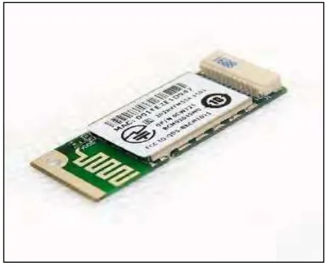
6 Figure 2.1 : GSM Modem
GSM modem can be used regarding sending as well as receiving the details. GSM modem can be talk with 2 approach relationship practice that's transmitter as well as device. GSM modem afforded a new SIM greeting card employs identical letters. GSM common performs on about three different carrier frequencies: this 900 MHz group, that has been as used by the original GSM process, this 1800 MHz group that has been added to help this puffiness volume of subscribes plus the 1900MHz rate of recurrence which mainly found in U.S . This specific composition can be obvious to see, successfully installable, very easily wide open as well as may be used regarding different reasons. ( Pankaj Verma and J.S Bhatia,2013)
2.1.2 Bluetooth
Figure 2.2 : Bluetooth Device
7 reliable, and also a force adept industry associated with back links with regard to interfacing electronic digital tools. Wireless bluetooth furthermore any short-go remote advancement outfitted with regard to presenting a lot of distance learning benefits.
Wireless bluetooth does not reinforce any sensor tradition, and that is discovered that has a meandering and also where handoff happens powerfully every time a Wireless bluetooth gizmo is usually going for more distance from the setting in the process. Wireless bluetooth advancement has turned into a essential bit of that leading edge contemporary society. The convenience involving mobile the radio, enjoyment controllers, Particular A digital Admin (PDA) and Computer systems possesses manufactured Wireless bluetooth a new popular advancement with regard to limited assortment rural letters.
Among the benefits of wireless bluetooth is actually shoddy, trustworthy, and a push skillful industry involving links with regard to interfacing electric gizmos. Wireless bluetooth furthermore a new short-go rural advancement outfitted with regard to supplying numerous letters benefits. Wireless bluetooth does not strengthen any sensor established practice, and that is recognized having a meandering and by which handoff transpires powerfully every time a Wireless bluetooth gizmo is actually shifting farther from your extent in the system.
8
2.1.3 Wireless Infrared Communication
Figure 2.3 : Infrared
Figure 2.3 has shown Wireless Infrared. Wireless Infrared Communication are utilized for short separation system associations. It need observable pathway and have its merits and faults. The assessment of the two transmission frameworks was in the ranges of recurrence range, data transfer capacity, specialized issues, secrecy, security issues, separation scope. When recurrence range authorizing is troublesome and costly to get, wireless infrared communication have a decent point of preference, and the wireless infrared communication is less disposed to be caught. (Okeke et.al 2014).
9 Infrared correspondence with ease and straightforward control of the usage, simple to-utilize and transmission attributes of high unwavering quality, is a more regular method for correspondence. Infrared correspondence as a short-run remote interchanges, has been generally utilized. (Xiao Chen and Chenliang Wu, 2011).
Figure 2.4 : Basic wireless infrared communication.(Prof. M. D. Nicose et al,2013).
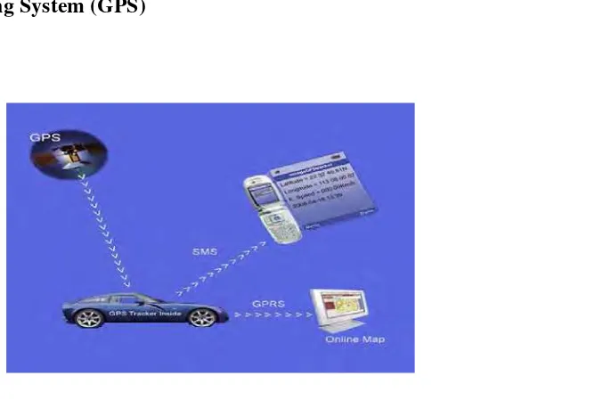
2.2 Global Positioning System (GPS)
Figure 2.5 : GPS system overview