Review on Tsunami Risk Reduction in Indonesia Based on Coastal
and Settlement Typology
Djati Mardiatno, M. Ngainul Malawani, Despry Nur Annisa, and Dandun Wacano
Received: September 2016 / Accepted: February 2017 / Published online: December 2017 © 2017 Faculty of Geography UGM and he Indonesian Geographers Association
Abstract his research aims to identify various coastal and settlement typology as the basis to determine action plan for reducing tsunami risk. he action plan were issued by referring to priority level of tsunami management. Comparative analysis was applied through comparing diferent coastal and settlement typology at the selected coastal area, considering the tsunami risk zones determined by National Disaster Management Agency (BNPB). he results show that mitigation strategies can be distinguished in various coastal and settlement typology for each priority area, i.e. in Mentawai megathrust, Sunda Strait and the southern part of Java, Bali region and Nusa Tenggara, and Papua region. he components of action plan should be conducted in accordance with the priority level of each region.
Key words: tsunami risk, coastal proile, settlement typology, priority level, InaTEWS
Abstrak Penelitian ini bertujuan untuk mengidentiikasi berbagai tipologi pesisir dan permukiman sebagai dasar untuk menentukan rencana aksi untuk mengurangi risiko tsunami. Rencana aksi dihasilkan dengan mengacu tingkat prioritas manajemen tsunami. Analisis perbandingan diterapkan dengan cara membandingkan tipologi pesisir dan tipologi permukiman pada daerah kepesisiran terpilih. Pemilihan daerah tersebut mempertimbangkan zona risiko tsunami yang telah ditentukan oleh Badan Nasional Penanggulangan Bencana (BNPB). Hasil penelitian menunjukkan bahwa strategi-strategi mitigasi dapat dibedakan pada setiap kawasan prioritas yang bervariasi tipologi pesisir dan tipologi permukimannya. Kawasan tersebut meliputi kawasan megathrust Mentawai, Selat Sunda dan bagian Selatan Pulau Jawa, wilayah Bali dan Nusa Tenggara, dan wilayah Papua. Komponen-komponen rencana aksi sebaiknya dilaksanakan dengan mempertimbangkan tingkat proritas pada masing-masing wilayah.
Kata kunci : risiko tsunami, proil kepesisiran, tipologi permukiman, tingkat prioritas, InaTEWS
1. Introduction
Tsunami is a series of long waves caused by displacement of plate tectonics or in general, it is a seaquake. Velocity of tsunami waves could reach 170 km/h, but when it reached the supericial velocity decreases but the wave height increases. Tsunami may take casualties, damage economic activity, as well as damage the ecosystem in coastal areas [UNESCO, 2011]. In other defenition, tsunami is a series of waves in a wave train, generated by sudden, vertical displacement of a column of water. his displacement can be due to seismic activity, explosive volcanism, a
lanslide above or below water, an asteroid impact, or certain meteorological phenomena. [Bryant, 2008]
Indonesia has a long history hit by earthquakes and tsunamis. Indonesia is situated between oceanic plate and continental plate, which resulted in the reality that geologically, Indonesia is always disturbed by the plates displacement. he plates found here are the Eurasian Plate, the Paciic plate and Indo-Australian plate. Since the last two decades (1990-2010), there have been ten tsunami disaster events in Indonesia that destructed many infrastructures and cause casualties. he tsunami events were in Flores [1992] with 2.500 fatalities; Banyuwangi, 238 fatalities [1994]; Biak, 110 fatalities [1996]; Maluku, 18 fatalities [1998]; Banggai, 4 fatalities [2000]; Aceh, 165.000 fatalities [2004]; Nias, 800 fatalities [2005]; West Java, 200 fatalities [2006]; Bengkulu, 25 fatalities [2007]; and Mentawai, 413 inhabitants [2010]. During the past two decades, about 170.000 people died due to tsunami [BNPB, 2012]. According to the historical tsunami event in Indonesia, tsunami most casualties was happened in Aceh [December 2004].
Learning from these experiences, Indonesian Government decided to create Indonesian Tsunami
ISSN 0024-9521
IJG Vol. 49, No.2, December 2017 (186 - 194) © 2017 Faculty of Geography UGM and he Indonesian Geographers Association
Djati Mardiatno
Research Centre for Disasters, Universitas Gadjah Mada Yogyakarta, Indonesia
M. Ngainul Malawani
MPPDAS, Faculty of Geography, Universitas Gadjah Mada Yogyakarta, Indonesia
Despry Nur Annisa
MPPDAS, Faculty of Geography, Universitas Gadjah Mada Yogyakarta, Indonesia
Dandun Wacano
Faculty of Civil Engineering and Planning, Universitas Islam Indonesia Yogyakarta, Indonesia
Correspondent email: [email protected]
7
Early Warning System (InaTEWS), initiated by the Coordinating Ministry for People’s Welfare; Ministry of Research and Technology; Indonesian Agency for Meteorology, Climatology, and Geophysics (BMKG); Indonesian Agency for the Assessment and Application of Technology (BPPT), Indonesian Agency for Geospatial Information (BIG); and a variety of other relevant agencies, assisted by several friendly countries such as Germany, Australia, Japan, and the United States. InaTEWS has been inaugurated by the President on September 11th, 2011 with centered at BMKG. In addition to provide tsunami warnings in Indonesia, InaTEWS is also functioned as a source of tsunami information for countries located adjacent to the Indian Ocean coast. Following up InaTEWS system, the Indonesian Government at the same time also has launched a Temporary Evacuation Sites (TES) development program.
InaTEWS system requires engagement, attention, and commitment of institutions at various levels as well as the general public and residents of the coastal communities at risk. here are four elements used in this system, such as understand the hazard and risk, forecasting by monitoring data and warning services, dissemination of warnings from BMKG to populations at risk, and acting on warnings.
TES is a program of development and it is developed for a temporary evacuation. TES has nine activities as follows: (1) Strengthening the manufacture of evacuation planning in the area including the tsunami hazard map or tsunami risk map which more detailed (regency level), as the basic for evacuation maps; (2) Preparation of evacuation planning and evacuation maps are ampliied with the general framework and policies in the region; (3) Development of tsunami evacuation nets; (4) Construction and development of tsunami TES; (5) Construction of paths and stairs evacuation; (6) Preparation of evacuation signs and warning boards; (7) Greenbelt for tsunami mitigation; (8) Preparation of an evacuation route map; (9) Socialization and dissemination of the TES. [BNPB, 2012].
InaTEWS system and TES program have already been implemented at the earthquake incident on April 11, 2012 in the western coast of Aceh. Viewed InaTEWS system elements and details of TES programs, eforts for disaster management by this system will be successful accordance with the target. But in the reality at the time, both eforts still have many weaknesses. Based on data from BNPB [2012], i.e. evaluation results from this disaster management system, there are three weaknesses as follows: (1) here is no clear division of roles between the local government and BMKG has made the people for evacuation; (2) he absence of guiding directions for evacuation so that most of people are still evacuating by using a vehicle and this causes congestion at the crossroads; and (3) Local people do not believe in supplying the building of TES so they
prefer to evacuate themselves to upper land despite the distance that may be taken away. According to the weakness of the results from the InaTEWS and this TES program, it would require a new approach to make eforts for disaster mitigation in Indonesia.
BNPB has decided the priority areas with high risk to tsunami in Indonesia. All regions cover an area which has a coastline facing the plate collision zones or subduction zones. In general, the region can be divided into four regional zones, namely Megathrust Mentawai Zone, Sunda Strait and the Southern Sea of Java Zone, Bali and Nusa Tenggara Zone, and Northern Papua Zone.
Based on these conditions, the characteristics of coastal areas will have diferent response to tsunami. he larger cities such as Aceh, Padang, Banten, Yogyakarta, to Jayapura will have a diferent response to tsunami.
On the other hand, BNPB settled the cities which have a high risk zone to tsunami. herefore, a speciic approach is required to prepare mitigation plans in those areas. An alternative for that purpose is by utilizing coastal and settlement typology approach, because every region has a variety of coastal and settlements typology. hrough this approach, it is expected to produce a mapping unit of tsunami risk and coastal areas proile to support the preparedness program for tsunami mitigation action plans. his idea is expected to support disaster risk reduction activities (Malawani and Mardiatno, 2015).
2. he Methods
Based on the earlier description, it is known that there are still weaknesses in the structure of tsunami disaster mitigation in Indonesia. It is necessary to create an alternative approach which is consistent with the characteristics of every region. Tsunami mitigation action plan is one of the plan management. Similar documents for that purpose is the National Action Plan for Disaster Risk Reduction (RAN-PRB) in a three-year time frame. his document explained that the RAN-PRB is the elaboration of National Disaster Management Plan (Renas PB) arranged to support policy formulation and monitoring in the implementation of disaster risk reduction activities [BAPPENAS and BNPB, 2012]. Framework used to create action plans through coastal and settlement typology approach is shown in Figure 1.
Djati Mardiatno, dkk
Figure 1. Research Framework
According to those areas, there are many people exposed to potential hazard of tsunami. More than 2,5 million people vulnerable to tsunami. he number of people exposed to tsunami can be seen in Table 2. Based on Dibyosaputro [2015], the residents usually prefer to live in the certain areas that potentially support their daily life. However, they sometimes do not care about the potential hazards occurrence since they only have limited options to select the location.
Under these conditions, there are challenges and opportunities on tsunami risk management in Indonesia. First challenge is: can tsunami risk management in Indonesia be run well in all regions? Many things that can be obstacles on the implementation of tsunami risk management in various region. Trouble may arise from the lack of preparedness or poor management that applied in various region. he characteristics of each region, both physical and anthropogenic factor can arise new challenge: is it able to apply the mitigation strategies according to the characteristics of each region? Study about tsunami mitigation plan in Indonesia become an interesting topic refer to all challenges mentioned before.
All challenges mentioned before give some opportunities to do. First opportunity is, tsunami risk management needs to be implemented according to the characteristics or proile of the region. In addition, keys of identiication in mitigation strategies also need to be arranged into more detailed scale. It is very important, because tsunami risk mapping guide in Indonesia was Table 1. Data and research materials
Data and Materials Source
Coastal typology Topography/slope Beach shape
Satellite images from Google Earth, Geoeye, Landsat, SRTM
Settlement typology Building density Type of building
Satellite images from Google Earth, Geo-eye, ield visit Existence of disaster
mitigation program
Field visit, literature study
Masterplan for Indonesian Tsunami Disaster
Reduction
BNPB, 2012
Sendai Framework for Disaster Risk Reduction 2015-2030 (Translation)
BNPB, 2015
3. Results and Discussions
directed in producing map at the district scale, i.e. 1:50.000 (see BNPB’s Head Regulation No 2/2012). It will need further identiication from standards that have been made for more detailed scale. his study provides an input to determine the mitigation strategies into detailed scale.
Figure 2. Potential Hazard of Tsunami Disaster in Indonesia [BNPB, 2012]
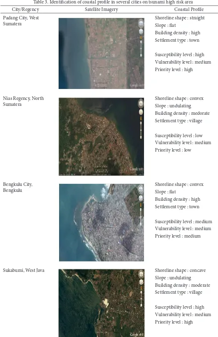
Triatmadja [2010] mentioned that tsunami disaster mitigation can be done by implementing two approaches, i.e. by physical and non-physical approach. Physical approach is similar to structural mitigation, while non-physical approach can be identical to non-structural mitigation. Both approaches would be diferent in each region. To distinguish that, it is necessary to propose an alternative method by creating new mapping unit. Based on the methodology previously mentioned, the function of mapping unit is to know the proile of the region based on coastal typology and settlement typology approach. To determine the mitigation strategies that it to the region’s proile, this method is applied at the several selected cities in tsunami high risk areas (Table 3).
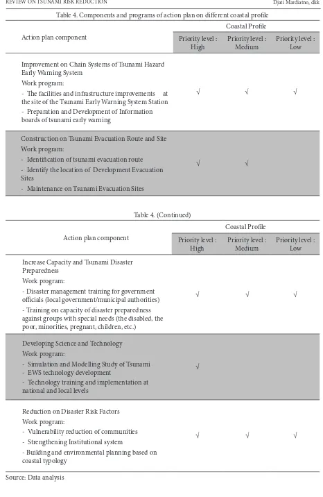
According to Table 3, it is known that several cities located in the high risk tsunami area in Indonesia have diferent coastal proile. his is an indication that tsunami risk management must be applied by diferent ways. In high priority level, surely the management must be better than in low priority level. Risk management can be detailed into action plan. Action plan consists of main component and derivative component that can be used as a work program. hese components can be assembled from several sources such as the National Action Plan for National Disaster Risk Reduction and Sendai Framework for Disaster Reduction 2015-2030. he components and program of action plan can be seen in Table 4.
Based on the matrix component of the action plan (Table 4), it can be seen that each coastal area needs diferent plan of action. At the irst priority level, all components of the action plan become mandatory and it is necessary to be inished in the short term. On the second priority, the development of science and technology does not become a fundamental things to be realized in the short term. It can also be found at the third priority area, where the development of tsunami evacuation is not essential to be established. It is caused by the fact that hazard and vulnerability are low in this priority. All components of the action plan presented in Table 4 are the main components which can be realized into mitigation action on each components. his approach is expected to be a new idea in the determination of the tsunami disaster mitigation actions at the local level in the high risk area to tsunami in Indonesia. It could be applied at the initial phase of tsunami risk analysis.
Table 2. Number of People Exposed in Priority Area of Tsunami Mitigation
No Priority area Province Nr. of people exposed
1 Megathrust Mentawai North Sumatra 106.601
West Sumatra 298.203
Bengkulu 98.246
2 Sunda Strait and Southern part of Java Lampung 43.004
Banten 346.381
West Java 123.095
Middle Java 943.497
DIY 92.342
East Java 194.649
3 Bali and Nusa Tenggara Bali 358.905
West Nusa Tenggara 119.138
East Nusa Tenggara 31.823
4 Papua region West Papua 14.092
Papua 20.998
Total 2.790.974
Djati Mardiatno, dkk
Table 3. Identiication of coastal proile in several cities on tsunami high risk area
City/Regency Satellite Imagery Coastal Proile
Padang City, West Sumatera
Shoreline shape : straight Slope : lat
Building density : high Settlement type : town
Susceptibility level : high Vulnerability level : medium Priority level : high
Nias Regency, North Sumatera
Shoreline shape : convex Slope : undulating
Building density : medorate Settlement type : village
Susceptibility level : low Vulnerability level : medium Priority level : low
Bengkulu City, Bengkulu
Shoreline shape : convex Slope : lat
Building density : high Settlement type : town
Susceptibility level : medium Vulnerability level : medium Priority level : medium
Sukabumi, West Java Shoreline shape : concave
Slope : undulating
Building density : moderate Settlement type : village
Pacitan, East Java Shoreline shape : concave Slope : lat
Building density : low Settlement type : village
Susceptibility level : high Vulnerability level : low Priority level : medium
Denpasar, Bali Shoreline shape : straight
Slope : lat
Building density : high Settlement type : town
Susceptibility level : high Vulnerability level : medium Priority level : high
Sorong, West Papua Shoreline shape : straight
Slope : lat
Building density : high
Settlement type : isherman
Susceptibility level : high Vulnerability level : high Priority level : high
Jayapura, Papua Shoreline shape : concave Slope : undulating Building density : high Settlement type : town
Susceptibility level : high Vulnerability level : medium Priority level : high
Djati Mardiatno, dkk
Table 4. Components and programs of action plan on diferent coastal proile
Action plan component
Coastal Proile Priority level :
High Priority level : Medium Priority level : Low
Improvement on Chain Systems of Tsunami Hazard Early Warning System
Work program:
- he facilities and infrastructure improvements at the site of the Tsunami Early Warning System Station - Preparation and Development of Information boards of tsunami early warning
√ √ √
Construction on Tsunami Evacuation Route and Site Work program:
- Identiication of tsunami evacuation route - Identify the location of Development Evacuation Sites
- Maintenance on Tsunami Evacuation Sites
√ √
Table 4. (Continued)
Action plan component
Coastal Proile Priority level :
High Priority level : Medium Priority level : Low
Increase Capacity and Tsunami Disaster Preparedness
Work program:
- Disaster management training for government oicials (local government/municipal authorities) - Training on capacity of disaster preparedness against groups with special needs (the disabled, the poor, minorities, pregnant, children, etc.)
√ √ √
Developing Science and Technology Work program:
- Simulation and Modelling Study of Tsunami - EWS technology development
- Technology training and implementation at national and local levels
√
Reduction on Disaster Risk Factors Work program:
- Vulnerability reduction of communities - Strengthening Institutional system
- Building and environmental planning based on coastal typology
√ √ √
Indonesian Journal of Geography, Vol. 49, No. 2, December 2017 : 186 - 194
Tsunami risk assessment is an important component. Strunz et al. [2011] mentioned that tsunami hazard assessment must consider all possible scenarios for the basis in conducting risk assessment. GITEWS project resulted in overview scale of several thematic maps and GIS information layers in the sub national level for western Sumatra, south of Java, and Bali. hat project also provided the detailed analysis scale in three pilot areas. However, it was issued before BNPB decided the Tsunami Masterplan for Indonesia in 2012, so that areas outside of GITEWS project are not covered. Based on Horspool et al. [2014], tsunami probability in the eastern part of Indonesia is like in the Sunda Arc part, so that more detailed tsunami risk analysis in the eastern part of Indonesia like in Moluccas, northern part of Papua and Sulawesi will be essential. According to this fact, it is very important to link the results from GITEWS and InaTEWS with Tsunami Masterplan produced by BNPB. Action plan components derived from coastal proile analysis are the eforts to synchronize both projects results.
Refer to Imamura et al. [2012], for tsunami mitigation plan, hazard information must consider the worst case scenario possibility, i.e. by estimating maximum inundation extent resulted from tsunami modelling. Regarding evacuation routes, the routes with high tsunami casualty index must be free from evacuation before tsunami comes. hese also should be clear from overcrowding during the evacuation. In the
lat area like in Padang city, it is necessary to integrate a comprehensive countermeasures for mitigating tsunami. It can also be implemented by using high building located inside the tsunami inundation area.
On the other hand, coastal materials should also be considered in mitigating coastal hazards such as tsunami. Mardiatno [2013] explained that coastal areas consist of sandy and muddy materials tend to have a high tsunami risk. Diferent mitigation treatment must be diferent for both areas, such as by planting diferent vegetation for each material to protect the coastal area from tsunami.
Coastal land use planning is also essential to minimize coastal hazards (e.g. tsunami) impact [Widianto and Damen, 2014]. It is a part of mitigation strategy for coastal area protection, which is very useful to preserve coastal resources and to safe people living in that location. Furthermore, the development of coastal forest as well as coastal belt boundary are also very important for tsunami mitigation [Mardiatno, 2013; Widianto and Damen, 2014]. It is a cheap alternative compared to hard construction development and oten applied in many countries.
4. Conclusions
Priority level of tsunami management in Indonesia is varied in several cities. Priority level is
composed from level of susceptibility and vulnerability. Priority level can be used to determine the action plan components. hese components can be simpliied into ive action plans classiication. hey should be conducted in accordance with the priority level of each region. Coastal materials and land use planning should also be considered at implementing the action plan for each region.
Acknowledgement
he authors would like to thank to all assistants that supported ield data collection. Many thanks is also given to Mr. Hariyadi, S.Si., for all valuable supports.
References
BAPPENAS and BNPB (2010). Rencana Aksi Nasional Pengurangan Risiko Bencana Tahun 2010-2012, Badan Perencanaan dan Pembangunan Nasional dan Badan Nasional Penanggulangan Bencana, Jakarta. (in Bahasa Indonesia).
BNPB (2011). Pedoman Umum Pengkajian Risiko Bencana untuk Rencana Penanggulangan Bencana, Badan Nasional Penanggulangan Bencana, Jakarta. (in Bahasa Indonesia).
BNPB (2012). Masterplan Pengurangan Risiko Bencana Tsunami, Badan Nasional Penanggulangan Bencana, Jakarta. (in Bahasa Indonesia).
BNPB (2013). Indeks Risiko Bencana Indonesia, Badan Nasional Penanggulangan Bencana, Jakarta. (in Bahasa Indonesia).
BNPB (2015). Kerangka Kerja Sendai untuk Pengurangan Risiko Bencana 2015-2030, (Translation), Platform Nasional PRB, Badan Nasional Penanggulangan Bencana, Jakarta. (in Bahasa Indonesia).
Bryant, E. (2008). Tsunami, he Underrated Hazard (2nd Edition), Praxis Publishing Ltd., Chichester, UK.
Dibyosaputro, S. (2015). Landform Control on Settlement Distribution Pattern in Progo Delta, Indonesia, Indonesian Journal of Geography, 47(2), 187-193.
Horspool, N., Pranantyo, I., Griin, J., Latief, H., Natawidjaja, D. H., Kongko, W., Cipta, A., Bustaman, B., Anugrah, S. D., and hio, H. K. (2014). A probabilistic tsunami hazard assessment for Indonesia, Nat. Hazards Earth Syst. Sci., 14(11), 3105-3122, doi: 10.5194/nhess-14-3105-2014. Imamura, F., Muhari, A., Mas, E., Pradono, M.H., Post,
J., and Sugimoto, M. (2012). Tsunami Disaster Mitigation by Integrating Comprehensive Countermeasures in Padang City, Indonesia,
Journal of Disaster Research, 7 (1), 48-64.
Djati Mardiatno, dkk REVIEW ON TSUNAMI RISK REDUCTION
tipologi pesisir dan permukiman, kasus pesisir
Jayapura, Proceedings on Simposium Nasional
Mitigasi Bencana Tsunami 2015, TDMRC-Universitas Syiah Kuala, Banda Aceh.
Mardiatno, D. (2013). A proposal for tsunami mitigation
by using coastal vegetations: some indings from
southern coastal area of Central Java, Indonesia,
Journal of Natural Resources and Development, 2013, 07, 85-95, doi: 10.5027/jnrd.v3i0.07.
Strunz, G., Post, J., Zosseder, K., Wegscheider, S., Mück, M., Riedlinger, T., Mehl, H., Dech, S., Birkmann, J., Gebert, N., Harjono, H., Anwar, H. Z., Sumaryono, Khomarudin, R. M., and Muhari, A. (2011). Tsunami risk assessment in Indonesia,
Nat. Hazards Earth Syst. Sci., 11(1), 67-82, doi: 10.5194/nhess-11-67-2011.
Triatmadja, R. (2010). Tsunami, Kejadian, Penjalaran, Daya Rusak, dan Mitigasinya, Gadjah Mada University Press, Yogyakarta. (in Bahasa Indonesia).
UNESCO (2008). Tsunami Preparedness-Information Guide for Disaster Planners, IOC Manuals and Guides No. 49, Intergovernmental Oceanographic Commission of UNESCO, Paris.
UNESCO (2011). Reducing and managing the risk of tsunamis, IOC Manuals and Guides No. 57. Intergovernmental Oceanographic Commission of UNESCO, Paris.
![Figure 2. Potential Hazard of Tsunami Disaster in Indonesia [BNPB, 2012]](https://thumb-ap.123doks.com/thumbv2/123dok/3651243.1465663/4.595.77.526.518.750/figure-potential-hazard-of-tsunami-disaster-indonesia-bnpb.webp)