1
Palang Merah Indonesia
BASELINE ASSESSMENT
Table of Content Acronyms
Chapter 1 Disaster Risk Context 1.1. Hazards Profile 1.2. Risk Analysis
1.3. Rationalization of Disaster Risk Reduction and Climate Change Adaptation
Chapter 2 PMI’s Auxiliary Function in Disaster Risk Reduction and Climate Change Adaptation
Chapter 3 PMI’s History in Disaster Risk Reduction and Climate Change Adaptation Programming
3.1. Policy, Strategy and Planning in Support of Disaster Risk Reduction and Climate Change Adaptation
3.2. PMI’s Services in Disaster Emergency Response
3.3. PMI Services in Disaster Recovery
3.4. PMI Services in Disaster Preparedness
3.5. Sector Based Programming
3.6. Cross Cutting Components of Community Safety and Resilience
Chapter 4 SWOT 4.1. Strength 4.2. Weakness 4.3. Opportunities 4.4. Threats
Chapter 5 PMI’s Capacity in the Implementation of Disaster Risk Reduction and Climate Change Adaptation
5.1. Human Resources 5.2. Tools and Infrastructure
5.3. Future Needs In Disaster Risk Reduction And Climate Change Adaptation
Chapter 6 External Relations and Coordination 6.1. At Regional Level
6.2. At National Level 6.3. At Provincial Level
Chapter 7 Objectives of Disaster Risk Reduction and Programme Priorities
3
ACRONYMSADPC Asian Disaster Preparedness Centre
Bakorsurtanal Badan Koordinasi Survei dan Pemetaan Nasional /national coordinating agency for survey and mapping
Bakornas Badan Koordinasi Nasional / national coordinating agency
Bappenas Badan Perencanaan Pembangunan Nasional / national development planning agency
BMKG Badan Meteorologi Klimatologi dan Geofisika / agency of meteorology, climatology
and geophysics
BNPB Badan Nasional Penanggulangan Bencana / national disaster management agency
BPBA Badan Penanggulangan Bencana Aceh / Aceh disaster management agency
BPBD Badan Penanggulangan Bencana Daerah / provincial disaster management agency
BPS Badan Pusat Statistik / central agency for statistics
CBAIC Community Based Avian Influenza Control
CBAT Community based action team
CBDP Community Based Disaster Preparedness
CBEWS Community Based Early Warning System
CBHFA Community Based Health and First Aid
CBRR Community based disaster risk reduction
CRED Centre for Research on the Epidemiology of Disasters
CSIRO Commonwealth Scientific and Industrial Research Organisation
Depkes Departemen Kesehatan / ministry of health
DiBa Data Informasi Bencana Aceh / Aceh disaster information data
DMIS Disaster Management Information System
DNPI Dewan Nasional Perubahan Iklim / national council for climate change
DVI Disaster Victim Investigation
EEPSEA Economy and Environment Program for Southeast Asia
ENSO El Nino Southern Oscillation
FA First aid
H2P Humanitarian Pandemic Preparedness
HDI Human Development Index
HFA Hyogo Frameworks for Action
ICBRR Integrated Community Based Risk Reduction
ICRC International Committee of Red Cross
IDRC International Development Research Centre
IDU Injecting Drug User
IESR Institute for Essential Services Reform
IFRC International Federation of Red Cross and Red Crescent Societies
IPCC Intergovernmental Panel for Climate Change
IEC Information, education and communication
Komnas FBPI Komite Nasional Pengendalian Flu Burung dan Kesiapsiagaan menghadapi
PandemiInfluenza / national committee for avian flu response and influenza pandemic preparedness
KTSP Kurikulum Tingkat Satuan Pendidikan / education unit level curriculum
KPB Konsorsium Pendidikan Bencana / disaster education consortium
KPAP/KPAD Komisi Penanggulangan AIDS Provinsi/Daerah / provincial AIDS management
commission
KSR Korps Suka Relawan / volunteer corps
MAT Medical Action Team
Musrenbang Musyawarah Perencanaan dan Pembangunan / planning and development
conference
NFI Non Food Items
NGO Non-government organization
OD Organizational Development
ORARI Organisasi Radio Amatir / amateur radio organization
PHAST Participatory Hygiene and Sanitation Transformation
PHBS Perilaku Hidup Bersih Sehat / clean and healthy behaviour
PLWHA People living with HIV/AIDS
PMI Palang Merah Indonesia / Indonesian Red Cross
PMR Palang Merah Remaja / Youth Red Cross
Posko Pos Komando / command post
Planas PRB Platform Nasional Pengurangan Risiko Bencana / national platform for disaster risk reduction
PNS Partner National Societies
PMB-ITB Pusat Mitigasi BencanaInstitut Teknologi Bandung / disaster mitigation centre of
the Bandung Technology Institute
Podes Potensi Desa / village potential
PSB-IPB Pusat Studi Bencana Institut Pertanian Bogor / Bogor Agricultural Institute disaster
study centre
PUSKRIS UI Pusat Krisis Universitas Indonesia / University of Indonesia crisis centre
RAD Rencana Aksi Daerah / provincial action plan
RAPI Radio Antar Penduduk Indonesia / Indonesian intra community radio
RAN PRB Rencana Aksi Nasional Pengurangan Risiko Bencana / disaster risk reduction national
action plan
RAN PI Rencana Aksi Nasional Perubahan Iklim / climate change national action plan
RFL Restoring Family Links
RKD Relawan Kesehatan Desa / village health volunteers
RPJM Rencana Program Jangka Menengah /medium term programme plan
RKD Relawan Kesehatan Desa / village health volunteers
RDMC Regional Disaster Management Committee
RDRT Regional Disaster Response Team
Satgana Satuan Penanganan Bencana / disaster response unit
SC-DRR Safer Communities through Disaster Risk Reduction
SKPD Satuan Kerja Perangkat Daerah / provincial work unit
SNP3RB Strategi Nasional Pengarusutamaan Pengurangan Risiko Bencana kedalam Sistem
Pendidikan / national strategy for disaster risk reduction mainstreaming in education system
SOP Standard Operating Procedure
SSB Sekolah Siaga Bencana / disaster prepared school
SRC Satuan Reaksi Cepat / rapid reaction unit
TSR Tenaga Sukarela / professional volunteers
UNDP United Nation Development Program
VCA Vulnerability and Capacity Assessment
WASH Water and Sanitation, Hygiene
5
1. Disaster Risk ContextIndonesia is the largest archipelago in the world. It stretches 3,977 miles between the Indian Ocean and the Pacific Ocean. The land area is 1,922,570 square kilometres and its waters 3,257,483 square kilometres. Indonesia comprises of five major islands, namely Java with an area of 132,107 square kilometres, Sumatra with an area of 473,606 square kilometres, Kalimantan with an area of 539,460 square kilometres, Sulawesi with an area of 189,216 square kilometres, and Papua with an area of 421,981 square kilometres.
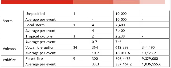
Over the last decades, the number of disaster in Indonesia, whether natural or not, have increased every year. Based on the data collected from the Centre for Research on the Epidemiology of Disasters (CERD), between 1980 and 2009, more than 19,929,305 people of Indonesia have been impacted by 309 different disasters, or about 64,496 people per disaster occurrence. The natural disasters which struck Indonesia within the period of 1980 to 2008 have caused economic loss of approximately USD 21,454,183. This means, per year, Indonesia has suffered economic loss of USD 69 million per disaster occurrence. Although the disaster data of this period indicates that most of the deaths were caused by earthquakes and tsunami, the largest percentage of population affected by this disaster were affected by climate related disasters (see table 1 below).
Table 1: Summary of Natural Disaster in Indonesia (1980-2009)
Storm
Volcanic eruption 34 364 612,393 344,190
Average per event 10.7 18,011.6 10,123.2
Wildfire
Forest fire 9 300 303,4478 9,329,000
Average per event 33.3 337,164.2 1,036,555.6
Source: "EM-DAT: The OFDA/CRED International Disaster Database, www.em-dat.net - Université Catholique de Louvain - Brussels - Belgium"
This was supported by the Global Assessment Report of 2009 on the mortality risk of various disaster occurrences, which identified that one of the main disaster risks in Indonesia is earthquake, followed by flooding and landslides.
Table 2: Mortality Risk from Various Hazards (0 = Very Low Risk; 10= Very High Risk) Multiple
Source: Global Assessment Report Disaster Risk Reduction, United Nations, 2009.
1.1.Hazard Profile
The following sub-chapter will elaborate on the thematic map of each hazard type in Indonesia, namely earthquakes, tsunami, landslides, volcano eruption, flood, drought, and climate change. Furthermore, PMI-ITB, PSP-IPB and the World Bank (2009) have developed a disaster risk index based on the calculation of combined factors, among others: hazard, exposure (including population exposure, physical exposure, and economic/livelihood exposure), vulnerability (including population and income per capita, infrastructure vulnerability and land use), and emergency response capacity (planning, resources, and mobilization capacity).
1.1.1. Earthquake
Indonesia has three active tectonic plates, causing tectonic earthquakes in the areas where the plates meet. The movement of the Eurasian plate which meets the Indo-Australian plates causes a 77mm shifts per year. The active plates of Eurasia stretch from the west coast of Sumatra to the south coast of Java, the Flores Sea and Arafura Sea. The Pacific plate stretches from the north of Papua to the Halmahera islands and Sulawesi. This tectonic condition of Indonesia is the cause of
Indonesia’s high earthquake potential. (See figure 1)
7
earthquake occurrences caused many losses of lives as well as damages to buildings, houses and infrastructures.Figure 1. Indonesian Seismic Map of 1900 – 2006 Source: BMKG, 2009
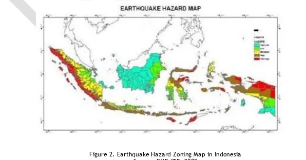
The Indonesian earthquake hazard zoning map developed by the Bandung Technology Institute
disaster mitigation centre (Pusat Mitigasi Bencana-Institut Teknologi Bandung/PMB-ITB) shows that
almost all of Indonesia is prone to earthquake in the future, with intensity varying from very low to very high. High intensity earthquakes are estimated to potentially occur in the west coast of Sumatra and the south coast of Java, all of Nusa Tenggara, centre to north of Irian, Maluku Islands, and centre to north of Sulawesi. Medium intensity earthquakes are estimated to potentially occur in the centre to east of Sumatra, centre to north of Java, centre to south of Irian, and centre to south of Sulawesi. Low intensity earthquakes potentially occur in Riau Islands, Central Java, northern part of East Java, southern part of Irian and Kalimantan (see figure 2). Based on the disaster risks index, the areas with high and highest risk of earthquake are located in the west part of Sumatra, south of Java, Bali, West Nusa Tenggara, East Nusa Tenggara, central and northern part of Sulawesi and part of Papua.
Figure 2. Earthquake Hazard Zoning Map in Indonesia Source: PMB-ITB, 2009
1.1.2. Tsunami
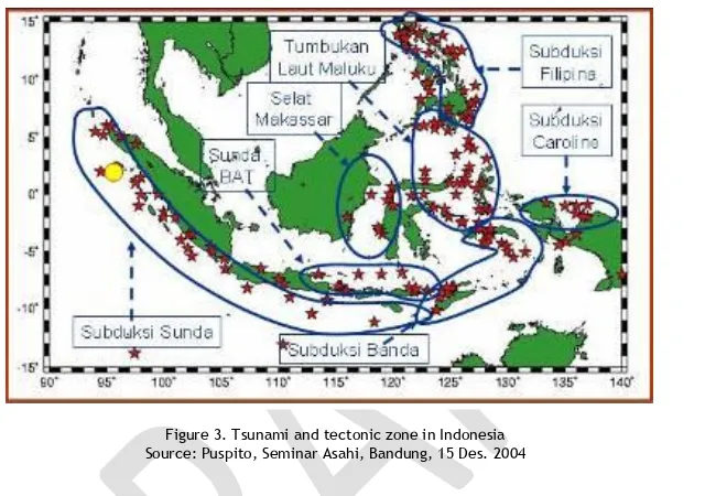
landslide. The high intensity of tsunami occurrences in Indonesia is closely linked to the tectonic plates on which the Indonesian archipelago is situated. Indonesia, particularly the eastern part, is the meeting point of three main plates: the Eurasian plates, the Indian-Australian plates moving to
the north, and the Carolina (Pacific) plates moving to the west. The plate’s border with high seismic
activity is located in the offshore of Sumatra, Java, Nusa Tenggara, Banda, Sulawesi and Papua (figure 3). This condition causes the probability of earthquakes which would trigger high wave tsunami particularly in the eastern part of Indonesia.
Figure 3. Tsunami and tectonic zone in Indonesia Source: Puspito, Seminar Asahi, Bandung, 15 Des. 2004
The most devastating tsunami, causing the most massive and widespread destruction in the history of the world, occurred in the Indian Ocean, triggered by an 8.9 Richter scale earthquake which struck in the area of Simeulue Island in Aceh province on 26 December 2004. This tsunami razed Banda Aceh, the west coast of NAD province and Nias Island. The impact and devastation was also felt in other countries around the Indian Ocean, such as Thailand, Malaysia, Andaman and Nicobar Islands, Sri Lanka, even all the way to the East African coast. The number of casualties in NAD province and Nias Island (North Sumatra) reached 165,862 people (including 37,066 people missing). The total loss caused by this disaster is estimated at 41 trillion rupiahs, not including indirect losses
such as disruption in the production process and community’s economy.
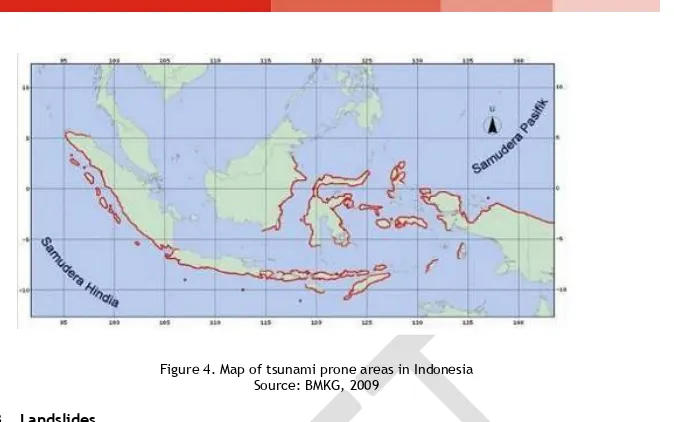
The tsunami in Indonesia possesses a unique characteristic, being a local tsunami which delay between the earthquake and actual tsunami was 20 to 30 minutes. This is due to the close proximity of tectonic plates with underwater earthquake potential, triggering a tsunami at the coastal line. Based on the tsunami occurrence history, tsunami prone areas were identified as being coastal areas directly facing the meeting of tectonic plates, among others the west coast of Sumatra, south of Java, Nusa Tenggara, north of Papua, Sulawesi and Maluku, as well as east of Kalimantan (figure 4).
9
Figure 4. Map of tsunami prone areas in IndonesiaSource: BMKG, 2009
1.1.3. Landslides
Landslides are often equated with ground movement by laymen as it is movement of the ground as a result of disruption in land stability at the foot of the hills. Landslides in Indonesia often occur in hills with large degree of steepness, and occur during times with high degree of rainfall. Based on disaster records, areas prone to ground movement are located along the mountains of Bukit Barisan in Sumatra and the mountainous areas of Java, Sulawesi and Nusa Tenggara. Ground movement also occurs yearly, particularly in areas with unstable land such as in West and Central Java. In addition to being triggered by high degree of rainfall, such land movement could also be caused by earthquake tremors. Several earthquakes in Indonesia which triggered landslides are among others the Palolo earthquake (2005), Bantul earthquake (2006), Solok earthquake (2007), Muko-Muko earthquake (2007), Painan earthquake (2007), and others.
Most of the land in the tropical countries is easily eroded due to the high weathering level of rocks in this area, and the physical land composition is dominated by free moving materials and layers as well as landslide potentials. The stability of land is very much influenced by the destruction of the forest buffer in Indonesia. Due to excessive logging, the number of areas prone to disaster in Indonesia has increased. For example, in 1990, West Java had a forest area of 791,519 hectares (approximately 22 percent of the province area), but in 2002 the forest only made up an area of 323,802 hectares (approximately 9 percent of the West Java area), which caused landslide occurrences in this province.
Based on the land movement risk evaluation, areas spread across Sumatra Island, Java, Kalimantan, Sulawesi, Bali, Nusa Tenggara, Maluku Island and Papua has been identified as areas with high and medium risk of land movement (figure 5). Furthermore, based on the disaster risk index, most cities or districts with very high risk of landslides are spread in the west part of Sumatra Island, south part of West Java, most of Papua and West Papua, centre and north part of Sulawesi, east part of Kalimantan, west part of West Nusa Tenggara, centre and south-east part of Sulawesi, as well as some part of Maluku province.
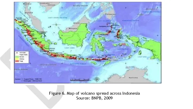
1.1.4. Volcanic eruption
Indonesia is encircled by a series of active volcanoes, spreading from Aceh to the Aru Sea in the west and south part of Indonesia, and from Sulu Sea to Tomini Strait as well as stretching along the west coast of Halmahera Islands (figure 6). Known as the 'ring of fire', Indonesia's volcanoes form a 7,000 kilometres long row. There are 129 active volcanoes spread in Sumatra Island, Java, Bali, Nusa Tenggara, North Sulawesi and Maluku Islands, in addition to 500 volcanoes which are inactive but the country still needs to be wary of. The number of active volcanoes in Indonesia makes up 13 percent of all active volcanoes in the world. Currently, more than 10 percent of Indonesian population reside in areas of active volcanoes. For the last 100 years, more than 175,000 lives have been lost due to volcano eruptions.
Located in the tropics, Indonesia has the rainy season and the dry season. Other than the volcanic eruption hazard in forms of material spew or toxic gas, during the rainy season, the volcanoes also pose an indirect threat such as lava or other hazardous volcanic material mudflow. Based on the disaster risk index, most of districts/cities with very high risk and high risk of volcanic eruption are mostly located in Java Island. However, there are many districts with high risk and very high risk located in Sumatra Island, most of West and East Nusa Tenggara, as well as north part of Sulawesi.
Figure 6. Map of volcano spread across Indonesia Source: BNPB, 2009
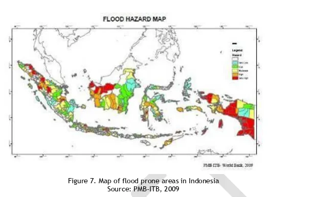
1.1.5. Floods
11
Figure 7. Map of flood prone areas in IndonesiaSource: PMB-ITB, 2009
Taking into account the indicators related to rainfall and the topography of land, it has been identified that most of Indonesia has a medium to high risk level of floods; areas with only low risk of floods are located in a small area in Sumatra, the south part of Java, Sulawesi and Nusa Tenggara (figure 7). Based on the disaster risk index, the districts/cities with very high risk of floods is spread in the five major islands of Indonesia. North Jakarta and West Jakarta are the districts in DKI Jakarta with very high risk of floods, as well as Indramayu which is known as a flood prone area in the West Java province. There are 18 districts/cities in East Java with very high risk of floods, such as Sidoarjo and Bojonegoro. Other high risk districts/cities are spread out, among others in Aceh, North Sumatra, Kalimantan, Sulawesi, East Nusa Tenggara and Papua.
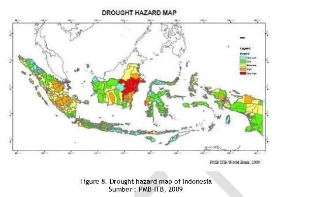
1.1.6. Drought
The Indonesian archipelago located at the equator between two continents and two oceans has a unique climate and is prone to regional and global climate changes. In the last 15 years, a strong El Nino occurred in 1997, resulting in almost all areas of Indonesia having less than normal rainfall, increasing the risk of drought, further impacting agriculture, forestry, fishery and other livelihood sector.
From 43 droughts in Indonesia, only six were not related to the El-Nino. However, the impact of the El-Nino to the rainfalls variability in Indonesia differs between locations. The El-Nino had a strong impact to areas affected by strong monsoon system; in areas affected by weak equatorial system its impact was very low, while the impact to areas with strong local influence is not clear.
Figure 8. Drought hazard map of Indonesia Sumber : PMB-ITB, 2009
Referring to the drought hazard map, the disaster risk index shows that most districts/cities with very high risk of drought are located in Java and Sumatra. In Java, the number of districts/cities with very high risk of drought are located in Central Java province (25 districts/cities), followed by West Java province (15 districts/cities), and East Java province (14 districts/cities). In Sumatra, the areas with high risk of drought are located in South Sumatra, Lampung and Riau Islands.
1.1.7. Climate change
The impact of global warming has affected Indonesia. In Indonesia, there has been an increase of 0.3 degrees Celsius since 1990. In 1998, the temperature has reached its highest point, approximately 1 degree Celsius above average temperature during the period of 1961-1990 (M. Hulme, 1999). Several scenarios projecting the increase of temperature in Indonesia (CSIRO, 1992 and 1993) shows that the CO2 concentration will increase twice as much, followed by increase of temperature by an average of 3 to 4.2 degrees Celsius. The yearly rainfall has also decreased by 2 to 3 percent, and the seasons have also changed.
13
Figure 9. Incidence of dengue and the number of affected cities and districts, 1968-2003Source: Ministry of Health on www.tempointeraktif.com
Climate-related hazards in Indonesia are also caused by the location and movement of tropical cyclones in the south-east of the Indian Ocean (from January to April) and the east of Pacific Ocean (from May to December). The impact of these tropical cyclones in Indonesia is in the form of strong wind, and heavy rain over a period of hours, sometimes days. Strong winds also occur during the transition period from the northeast monsoon into the southwest monsoon and vice versa.
The combination of the population density, the high level of biodiversity and 80,000 kilometres of coastal
line (which makes up 14 percent of the world’s coastal lines) and 17,500 islands has made Indonesia
vulnerable towards climate change impacts. The rainfall pattern will change and the dry season will last longer. Many islands are at risk of being submerged due to the rising of sea level, and many other impacts will emerge. According to the ministry of marine affairs and fisheries, within only two years (2005-2007), Indonesia has lost 24 small islands in Aceh, North Sumatra, Papua, Riau Islands, West Sumatera, South Sulawesi and Thousand Islands area. In these cases, the people most vulnerable against the rising of the sea level and tropical cyclone are the farmers and fishermen.
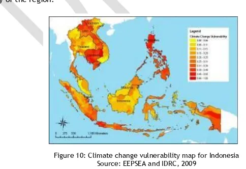
In 2009, the Economy and Environment Program for Southeast Asia (EEPSEA)
,
InternationalDevelopment Research Center (IDRC)developed a ‘climate change vulnerability, adaptive capacity and exposure map’ for South East Asia. A hazard map for five disaster risks related to climate
change, namely floods, landslide, drought, tropical cyclones and rising of sea level has also been
created. The ‘population density’ variable was used to represent the people’s sensitivity towards climate hazard exposure, while the ‘protected area’ variable is considered to represent ecological
sensitivity of the region.
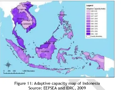
Figure 10: Climate change vulnerability map for Indonesia Source: EEPSEA and IDRC, 2009
analyzing the climate hazards, exposure and adaptation capacity in Indonesia, the high risk level is determined by high risk of climate hazard, high exposure level and low level of adaptation capacity (according to HDI).
Figure 11: Adaptive capacity map of Indonesia Source: EEPSEA and IDRC, 2009
According to the above EEPSEA and IDRC research results, areas with high risk are located in highlands in the centre and south of Papua, DKI Jakarta and West Java, West and South Sumatra. Areas with medium risk are North and Central Sulawesi, other parts of Sumatra, East Java and East Nusa Tenggara. The lowest adaptation capacity is recorded in Papua and East Nusa Tenggara. In almost 100 percent of the Indonesian islands, the population are mostly concentrated in the coastal areas with low elevation (less than 10 metres) which is exposed to high risk of the sea level rising.
To illustrate the rising sea level hazard, the Institute for Essential Services Reform (IESR) conducted a research to project the impact of the rising sea level to Java Island, an island where more than half of the Indonesian population reside. The research shows that in 2010, 2025, 205 and 2100, the areas which would be submerged by the sea will be 40 square kilometres, 66.6 square kilometres, 111 square kilometres and 138.8 square kilometres respectively. From this projection, it can be concluded that the vulnerability against climate change, particularly the rising of sea level will also increase every year (IESER, 2009).
1.2.Risk Analysis
In general, Indonesia has the following vulnerabilities.
Physical vulnerabilities:
Located in the area of three plates, namely the Indo-Australian, Euro-Asian and Pacific plates, the meetings of these three plates create an earthquake path and a series of active volcano across Sumatra Island, Java, Bali and Nusa Tenggara. Indonesia has more than 500 volcanoes, of which 128 are active. This line of volcanoes is part of the Pacific ring of fire. Additionally, as Indonesia is located in a tropical climate area, Indonesia has the potential of natural disaster risks such as flooding, landslides, forest fire and drought. Furthermore, Indonesia faces many natural disasters related to global climate change, such as tidal wave, coastal abrasion, drought, floods and landslides.
Social economic vulnerabilities:
According to Podes data of 2008, Indonesia’s population reached 231,640,960 people, with a population growth rate of 1.3 percent during the period of 2000-2005. The main issue faced by Indonesia is the uneven distribution of population, with 58.3 percent of the population concentrated in Java and Madura in 2008. From social economic perspective, Indonesia still has a relatively high
poverty number of 37,168,300 (statistic centre agency/Badan Pusat Statistik or BPS data of 2008)
15
7.47 percent. From the health perspective, Indonesia’s life expectancy is 68.7 percent. The infant
mortality rate in 2005 is 32 deaths per 1,000 births. Meanwhile, the gross domestic product per capita is IDR 15,628,050 and the real population expenditure per capita of 2007 is IDR 627,270.
Institutional/organizational vulnerabilities:
The national disaster management institution is the authority of the national disaster management
agency (Badan Nasional Penanggulangan Bencana/BNPB) which replaces the role of Bakornas PBP
(Badan Koordinasi Nasional Penanggulangan Bencana dan Pengungsi or the national coordinating agency for disaster and displacement management) according to the mandate assigned by Law
number 24 of 2007 on disaster management. The provincial disaster management agency (Badan
Penanggulangan Bencana Daerah/BPBD) at the provincial and the district level were also endorsed by the head of BNPB regulation number 3 of 2008. In 2009, only a few provinces have endorsed the
establishment of BPBD while other provinces are still using the previous structure of Satkorlak
(satuan koordinasi pelaksana penanggulangan bencana or disaster management implementation
coordination unit) at the provincial level and Satlak (satuan pelaksana penanggulangan bencana or
disaster management implementation unit) at the district level.
Additionally, a number of universities have disaster study centres or similar, among others the Institute of Technology in Bandung (ITB), University of Gajah Mada (UGM), Institute of Technology Surabaya (ITS), university of national development (Universitas Pembangunan Nasional/UPN), Institute of Agriculture Bogor (Institut Pertanian Bogor/IPB), and Syah Kuala University. There are also many organizations, whether local, national and international, who are concerned with disaster management. The increased number of organizations responding to disasters is an advantage; however, on the other hand, these also undeniably pose additional challenges in the implementation. Coordination has always required special attention in terms of implementation in the field.
1.3.Rationalization of Disaster Risk Reduction and Climate Change Adaptation
In the global risk analysis prepared by the World Bank, Indonesia was identified as one of 35 countries with a high risk of deaths due to multiple hazards, with 40 percent of population living in high risk areas. With a population more than 230 million people, this means more than 90 million people are vulnerable to disaster and climate change threats.
Disaster slows down development. Repeated large scales disasters destroy buildings and infrastructures, which directly and indirectly hampers the development agenda. Destruction caused by these disasters also hinders economic growth. Economic pressure could decrease the quality of environment, particularly logging, causing further severe drought, as well as floods.
The impoverished are almost always the most affected when a disaster strikes, as they tend to reside in hazardous areas such as flood prone areas, river banks, steep hills and reclaimed land. The lack of resources results in difficulties for the impoverished people to maintain their livelihood and homes in times of disasters. Climate change, unplanned urban settlements, and other problems such as poverty and population growth contribute in the increased individual and community vulnerability, particularly the economically disadvantaged, and create additional risk-causing factors which would require specific humanitarian action.
In 2005, 168 countries attended the World Conference on Disaster Risk Reduction in Kobe, Japan, and adopted the Hyogo Framework for Action 2005-2015 as a global agenda to reduce disaster risks. In support to this global commitment, the Government of Indonesia has formulated a national action
plan for disaster risk reduction (Rencana Aksi Nasional Pengurangan Risiko Bencana/RAN PRB) for
2006-2009 as a follow up to the commitment towards the Hyogo Framework for Action 2005-2015 (HFA), by elaborating on five priorities of the HFA, namely (1) Ensure that disaster risk reduction is a national and local priority with a strong institutional basis for implementation; (2) Identify, assess and monitor disaster risks and enhance early warning; (3) Use knowledge, innovation and education to build a culture of safety and resilience at all levels; (4) Reduce the underlying risk factors; (5) Strengthen disaster preparedness for effective response at all levels. Since 2007-2008, the Government of Indonesia has included disaster risk reduction programme in their regular development programme. Currently, the RAN PRB 2006-2009 is in its last year of implementation and will be soon evaluated, and a new plan RAN PRB 2010-2012 will be formulated with the involvement of government institutions, NGO, donors, etc.
Indonesia has ratified the United Nations Framework Convention on Climate Change through Law number 6 of 1994. Ten years on, Indonesia ratified the Kyoto protocol through Law number 17 of 2004. These commitments require comprehensive efforts and action in adaptation and mitigation. In 2007, under the coordination of the ministry of environmental affairs, a national action plan in
facing climate change (Rencana Aksi Nasional dalam Menghadapi Perubahan Iklim/RAN PI) was
formulated as a guideline in carrying out coordinated and integrated efforts in mitigation and adaptation of climate change, in line with the national development objectives. The development of climate change adaptation capacity in the future should be based on experience and the capacity built to overcome disaster risks related to the current climate. Therefore, the formulation climate change adaptation agenda must be linked to the national action plan for disaster risk reduction.
In addition to that, the Law number 27 of 2007 on coastal and small islands management mandated that in facing climate change in the coast and small islands, disaster risk reduction needs to be integrated in the coastal and small islands management and utilization plan, involving responsibilities from the central government, provincial government and/or the community.
Disaster risk reduction and climate change adaptation has the same concern and objective, namely to increase the resilience and reduce vulnerability to threats and impacts caused by disasters and climate factors. Therefore, in its implementation, both need close cooperation between sectors and an integrated development planning system. On the contrary, the aim/objectives of the mid term and long term development formulated in the provincial/national development plan will risk not being achieved if the threats and impact of climate change is not responded through holistic and appropriate policies and strategies.
The enactment of Law number 24 which was endorsed by the people's representative council (Dewan Perwakilan Rakyat/DPR) on 29 March 2007 contains the spirit of change in the Government
of Indonesia paradigm in terms of disaster management: first, a change from disaster response to
disaster management which encourages change from action limited to emergency situation to
holistic disaster management before, during and after disaster occurrence; second, a change of
mindset that safety and protection is the people’s basic rights, not a gift from the government; third, disaster management is no longer the government’s affair alone, but is a common concern and involves the wide community’s participation. Soon after the disaster response law number 24 of 2007 was endorse, the Government of Indonesia formed the national disaster management agency (Badan Nasional Penanggulangan Bencana/BNPB) through the presidential regulation number 8 of 2008. The BNPB is accountable directly to the President of the Republic of Indonesia, and is responsible to formulate and issue policies on disaster management and coordinate disaster management activities in a planned, integrated and comprehensive manner.
The importance of disaster risk reduction has also been reflected in the Agenda for Humanitarian
Action, adopted in the 28th International Conference of the Red Cross and Red Crescent in December
2003. In this conference, the Red Cross and Red Crescent Movement and countries parties to the Geneva Convention committed to take action in the aim of reducing vulnerabilities to risks and impacts of disasters. This commitment was further proclaimed in the International Federation of Red Cross and Red Crescent Societies Global Agenda Goal of 2006-2010 which explicitly calls for a collective action with the vulnerable community to reduce disaster risks. In building this global commitment, IFRC has formulated a framework to build a more resilient and safe community.
Some 11 national societies in Southeast Asia also realize the importance of disaster risk reduction. In a leadership meeting held in August 2009, a regional commitment was made to (1) position themselves as government partners in achieving the national commitment in meeting the Hyogo Framework for Action and advocate to the government at all levels in ensuring a community safe and resilient against disaster, reflected in policies, strategies and national programmes; (2) recommend disaster risk reduction as a holistic approach to the national society as a mainstreaming agenda and cross cutting theme for health, organizational development and disaster management.
17
2. PMI’s Auxiliary Function in Disaster Risk Reduction and Climate Change Adaptation
PMI’s mandate in disaster risk reduction is to assist and cooperate with the government, particularly in the humanitarian assistance aspect to vulnerable people. Additional to the main task of providing emergency assistance in times of disaster, as much as possible PMI also carries out Red Cross tasks before and after disaster occurs.
In carrying out its mandate, PMI has two main advantages: first, PMI has been acknowledged by the
Government of Indonesia and other policy makers to have the duty and responsibility of assisting, advising and advocating on disaster management, as an implementation of its auxiliary role to the government. PMI was established by the government and is recognized as the only Red Cross organization in Indonesia, based on the Presidential Decree number 25 of 1950 and Presidential Decree number 246 of 1963. By upholding the Red Cross principle of independence, PMI provides support to the government in forming a national platform involving representation of national and local level in supporting disaster risk reduction and decentralize responsibilities and resources.
Second, PMI has a network of grassroots volunteers originating from the community and living with the community. The mobilization of volunteer power supports an important contribution to gather
community’s input in the decision making process which would affect the disaster risk reduction programmes in the community.
In the Disaster Management Law number 24 of 2007, PMI’s position in disaster management is not explicitly stated. In practice, this does not change PMI’s participation in carrying out disaster management activities in coordination with the government and other institutions. Taking into account this condition, a memorandum of understanding was signed on 23 March 2009 between PMI
and BNPB which stipulates both parties’ agreement to establish a partnership in carrying out
disaster management activities before, during and after disaster occurrences, in accordance with
each party’s roles. Through this MOU, PMI also committed to assist BNPB in the implementation and achievements of national, regional and international policy objectives on disaster risk reduction.
Under the coordination of the national development planning agency (Badan Perencanaan
Pembangunan Nasional/Bappenas), PMI has been actively involved in a working group to formulate
the national action plan of disaster risk reduction (Rencana Aksi Nasional Pengurangan Risiko
Bencana/RAN PRB) for 2004-2009 and 2010-2012 in achieving 5 HFA 2005 – 2015 priorities. To effectively achieve the HFA objectives, PMI has developed a close partnership with government ministries and institutions such as the ministry of health, ministry of national education, ministry of environmental affairs, BNPB, etc.
In 2008, the Government of Indonesia under the lead of Bappenas, ministry of internal affairs, BNPB and funding support from the United Nations Development Program (UNDP) carried out a Safer
Community through Disaster Risk Reduction (SC-DRR) programme, aiming at increasing community’s
resilience through disaster risk reduction. One of the important components in the SC-DRR
programme is increasing the community’s understanding on disaster risk reduction through
education and public awareness programmes. In 2009, the SC-DRR has formulated a zero draft of
the national strategy of mainstreaming disaster risk reduction in education system (Strategi
Nasional Pengarusutamaan Pengurangan Risiko Bencana kedalam Sistem Pendidikan/SNP3RB). Under
the coordination of the disaster education consortium (Konsorsium Pendidikan Bencana/KPB), PMI
has been involved in the SNP3RB advocacy and campaign efforts to all stakeholders.
Awareness on Indonesia’s vulnerability to natural disasters and climate change has currently become Indonesia’s main concern. In the 2009-2014 programme of the ‘Indonesia Unite II’ cabinet (Kabinet Indonesia Bersatu), commandeered by the President of Indonesia, Susilo Bambang Yudhoyono, disaster risk reduction programme is one of the main programmes. To maximize disaster emergency response efforts at early stage, the Government of Indonesia has formed a rapid reaction unit (Satuan Reaksi Cepat/SRC) consisting of medical personnel and equipments, PMI, electricity and
energy technicians, the national defence force (Tentara Nasional Indonesia/TNI) and the Indonesian
national police (Polri), which under the coordination of the head of BNPB will carry out rapid assessment of disaster and its impact and provide assistance in disaster emergency response.
virus (Avian Influenza) in Indonesia, referring to the Presidential Instruction number 1 of 2007, PMI, under the coordination of the ministry of health and ministry of agriculture, has the role in increasing community based awareness and community based surveillance.
At the provincial level, PMI’s auxiliary function towards the provincial government in disaster
management is also implemented through PMI's role as the partner of the provincial disaster
management agency (Badan Penanggulangan Bencana Daerah/BPBD). PMI is also involved in the
formulation of the provincial action plan (Rencana Aksi Daerah/RAD) in which disaster risk reduction
is included as one of the provincial government’s programmes. Aside to that, PMI has also become a
member and active contributor in the disaster risk reduction formulation team, as well as the
provincial AIDS management commission (Komisi Penanggulangan AIDS Provinsi/Daerah or
KPAP/KPAD) under the coordination of the governor/bupati (head of sub-district). In Aceh, PMI is a
member of the Aceh formative platform (Formatur Platform Propinsi Aceh), supporting the
establishment of Aceh disaster information data (Data Informasi Bencana Aceh/DIBA) which is also
supported by UNDP, the provincial development planning agency (Badan Perencanaan Pembangunan
Daerah/Bappeda) and the national unity and community protection agency (Kesatuan Bangsa Perlindungan Masyarakat/Kesbanglinmas).
3. PMI’s History in Disaster Risk Reduction and Climate Change Adaptation Programming
Disaster occurrence is a phenomenon which can never be predicted by anyone. Any loss inflicted by
it will always cause a prolonged impact to the people’s quality of life, particularly the most
vulnerable. PMI is aware that disaster preparedness is important, but it is not always sufficient. Any actions and activities carried out by PMI in the disaster risk reduction and climate change adaptation is linked to the five priorities of HFA. However, as part of the larger Red Cross Red Crescent Movement, PMI strives to implement consensus in building a safe community resilient
towards disasters by empowering community’s capacity as the first responder in times of disaster or
in the integrated recovery efforts through disaster risk reduction and climate change adaptation efforts.
3.1.Policy, Strategy and Planning in Support of Disaster Risk Reduction and Climate Change Adaptation
In PMI’s strategic plan 2009-2014, PMI’s vision is described as ‘responsive and professional in carrying out Red Cross services’. This means, PMI will always put forward disaster risk reduction and climate change adaptation in the community professionally. To achieve this vision, PMI has elaborated four missions relevant to disaster risk reduction as follows:
1. Strengthen and develop organization
2. Increase and develop human resources quality
3. Increase quality of Red Cross services in line with the standard service for community needs
4. Develop community based Red Cross activities
In carrying out its mission to strengthen and develop organization, PMI strives to implement strategic activities such as (1) increase coordination capacity, facilities, assistance, and monitoring and evaluation from the central board to the chapters and from chapter board to the branches; (2)
increase the central board’s capacity in mobilizing national and international resources, and increased the capacity of the chapter and branch board in mobilizing local resources; (3) undertake organizational mechanism in a good and proper manner; (4) increase professionalism of PMI organizational management.
To increase and develop human resources quality, strategic activities are directed to: (1) carry out systematic and sustainable recruitment; (2) carry out planned and sustainable education and training with an integrated approach; (3) carry out mentoring for proportional and integrative human resources potential; (4) Orientation and applicative training for PMI board, staff and volunteers to increase appreciation of roles and responsibilities, supported by appreciation of humanitarian values, prior to deployment to the field.
PMI has also strived to mainstream disaster risk reduction and climate change adaptation in the
national agenda and integrate it into various PMI Red Cross services: (1) in disaster management
services, activities are carried out in a planned, holistic and integrated manner, applying
19
people affected by disasters, including ambulance facilities, first aid, water and sanitation, medicalaction team (MAT) and psycho-social support programme; (3) in social services, activities are
focused on vulnerable people, such as in clean water projects, dissemination and advocacy for
various transmittable diseases including HIV/AIDS and Avian Flu; and (4) in Restoring family links
programme services.
To achieve a safer community resilient to disasters, PMI has a mission to develop community based
Red Cross activities, hence, PMI’s activities are directed towards (1) increasing the capacity of local
community to the grassroots level to face various natural disasters as well as diseases with pandemic potential and environmental health which could be man-made, so that the community has the capacity and resilience in facing disasters; and (2) increase and empower local community leaders, both formal and informal, in management of disaster and pandemic potential diseases, and increase health status of the community in a community based manner and focused towards risk reduction.
3.2. PMI’s Services in Disaster Emergency Response
The disaster response over the last few years has been a valuable learning process for PMI. The disaster occurrences have triggered the establishment of many new organizations providing disaster
emergency services during disasters, ‘competing’ to provide its best services. This condition has motivated PMI to provide its best services in a timely, appropriate and coordinated manner when community based disaster preparedness (CBDP) and integrated community based risk reduction (ICBRR).
Referring to the disaster emergency response standard operational procedures, PMI ensures that
PMI’s disaster emergency response is suitable to the beneficiaries' needs, including the assessments,
first aid and rescue, evacuation and emergency shelters, MAT, ambulance, field kitchen, relief and distribution, water and sanitation, psycho-social support, restoring family links, etc. Policies and
planning of emergency response are also determined by PMI’s capacity in formulating operational plans as the basis for services and relief operation target achievements. However, reporting, monitoring and evaluation, capacity and organizational development, as well as transparency are still a challenge for PMI in realizing established operational plans.
At the PMI branch level, a disaster response team (Satuan Penanganan Bencana/Satgana) is
established, consisting of people recruited from the local community and come from various
backgrounds, including students, community leaders, and medical doctors who become PMI’s
spearhead in carrying out disaster response operations. However, the fact is not all PMI branch have the competence and skills according to the scope of disaster response services. The low skills and competence of the Satgana team will affect the determination of assistance priorities given to the affected people, which should be based on the level of needs. Aside to that, the availability of Satgana personnel equipment, relief items stock, emergency fund, and other tools and
infrastructures vary in each chapter and branches, which also affects PMI’s emergency response
service quality.
In the effort of expediting distribution in times of disasters, conflicts, other extraordinary events and epidemic, PMI has set up a logistics system by establishing a central warehouse, regional warehouses and disaster preparedness (DP) containers. However, some challenges in its operation have been encountered due to the uneven capacity in available space, management and relief items
stock as well as resources readiness of each chapter. Based on experience, PMI’s relief items
based on the needs assessment. Every PMI relief distribution is made in reference to PMI relief assistance principles: on time, right place, on target, right amount, and right quality.
In every disaster occurrence, the disaster emergency response command post (Pos Komando/Posko)
functions as the field operation control centre. Communication tool becomes a supporting tool of emergency response operations, particularly in disseminating disaster information. The disaster information system function using the Disaster Management Information System, one of the IFRC tools has been running well in expediting response of the decision makers by providing up to date information, facilitate international support to take proper action and at the same time ensures accountability to donors and community affected by the disaster. However, the disaster
management information system of PMI (Sistem Informasi Penanggulangan Bencana/SIPB) is not yet
operational nationally.
The lack of coordination and internal sectoral egoism within PMI in disaster emergency response operation causes overlapping and squander of resources, affecting effectiveness in determining policies and support to expedite community recovery from disaster impact. There is therefore a need for advocacy in the disaster response paradigm by not only focussing on emergency relief activities during disaster emergency response operation but also pay attention on the recovery aspect while the disaster operation is ongoing. Introduction and socialization of relief to recovery paradigm has been included in PMI disaster management training.
3.3.PMI Services in Disaster Recovery
The tsunami experience in Aceh in 2004 and the Bantul earthquake in 2006 has provided PMI with lessons learned that disaster recovery efforts must be carried out immediately without waiting for the disaster emergency response has completed. The emergency response should also consider long
term needs of the beneficiaries and identify efforts to increase the community’s capacity in the
disaster prone areas. The assistance given during emergency response should provide a strong
foundation to recover the community’s lives. Therefore, disaster recovery planning and programming should be carried out in synergy with emergency response and development planning with the involvement of the people affected by the disaster.
Based on experience, disaster recovery programme should start by focussing on the main needs of the people affected by disasters, such as temporary shelters integrated with water and sanitation as well as health promotion. Other than providing a reasonable basic housing, temporary shelters also provide community with safety to rebuild and continue their livelihood and economic activities. In responding to this need, PMI has trained its volunteers to facilitate the community in carrying out self-assessment on shelter needs, financial management as well as tools and material procurement required by the shelter design, Sphere minimum standard and gender sensitivity.
Livelihood programme development in Aceh after the tsunami in 2004 – such as cash for work - has
been carried out as a transition from emergency response into long term recovery – such as training,
agriculture, microfinance, etc. These are the activity components in which PMI has limited
management experience and skills. Therefore, increasing PMI staff’s understanding and capacity in
the livelihood concept and strategy is a key requirement in formulating livelihood strategy in disaster recovery. Establishing partnership with local and international non-government organization which support livelihood development programmes has become an important innovation for PMI in deriving benefits from the expertise of non-Red Cross actors.
In 2006, in cooperation with the ministry of health, PMI Bogor hospital has recruited and trained a number of doctors, nurses and specialists from general and private hospitals as medical action teams (MAT) to ensure access to health services, specifically for vulnerable community groups such as children, expectant mothers, senior citizens, etc. who live in emergency or temporary shelters. In practice, health services should also consider reproductive health such as antenatal and postnatal care, nutrition needs for expectant and nursing mothers, as well as sexual abuse risks. PMI should also activate potentials in the community such as midwives, local women associations, etc. to promote healthy and hygienic behaviour in maintaining environmental sanitation and prevent breeding of disease vectors.
Drastic and sudden environmental changes could cause decrease in the community’s social function.
21
disaster affected population facing psychological trauma. Before carrying out its task, PMI volunteers have been trained to identify social needs with the involvement of the beneficiaries, both children and adults. Based on the needs assessment results, the volunteers conducted regular visits to the selected villages and schools and conducted various activities which were considered effective and suitable to the psychosocial needs and local conditions, such as drawing, sports, traditional dancing shows, etc. To increase the effectiveness of its services, PMI also considered the psychological health of its volunteers involved in disaster response operations, by holding a debriefing session at the end of their mission. Currently, PMI has established a partnership with thecrisis centre of the University of Indonesia (Pusat Krisis Universitas Indonesia/PUSKRIS UI) to refer
people who need professional psychological help to mental health service providers.
Restoring family links (RFL) service activities has a positive impact to livelihood by facilitating the return of the breadwinners to their families and helping to reduce emotional distress due to loss of family members. Through capacity building for RFL supported by ICRC since 2006, PMI has placed
RFL as one of its main activities in disaster response. Using “I’m looking for” and “I’m alive” forms, the search for information of family members’ whereabouts is conducted by PMI volunteers in
health facilities and shelters with the support of satellite phones which are used when normal communication means are not functional after a disaster. To increase the quality of family restoration services, PMI utilized the opportunities of cooperation with relevant institutions. For example, PMI has established cooperation with disaster victim investigation (DVI) to match bodies of disaster casualties (through physical features, clothes, etc.) to information on missing people or people presumed to be dead.
3.4.PMI Services in Disaster Preparedness
With more than 200 million people affected by disasters every year, disaster preparedness is known to be an essential component in disaster management; however, this has not been considered sufficient. To anticipate this, PMI must always be prepared to provide its best services to the most
vulnerable communities. Aside to that, the community’s capacity in emergency response
preparedness, disaster impact mitigation and climate change adaptation must be increased.
To provide the best services during emergency response phase, in 2007, PMI has formulated a
standard operating procedure (Prosedur Tetap/Protap) for disaster emergency response which
defines the tasks and responsibilities at all levels. The general guidelines contained in thi s Protap
are elaborated more specifically in other policies such as implementation directives (petunjuk
pelaksanaan/Juklak) for PMI Satgana, Juklak for PMI disaster response post (Juklak Posko PB PMI),
and technical directives (petunjuk teknis/Juknis) for relief distribution which aims at strengthening
supporting elements of a disaster emergency response operation. All policies have been distributed and socialized to all PMI levels. However, the policies seem to not have been implemented maximally, whether by PMI headquarters, chapters or branches, particularly by the leadership. Internally, there is still a need for independent strengthening to widen the practice of the policies.
To enable the community as first responders during disasters, PMI needs to facilitate the
community in establishing resource mobilization scenarios relevant to the type of hazard in their environment. Until 2009, 25 PMI chapters have formulated draft contingency plans in relation to the local disasters. Vulnerability and capacity assessment analysis which is the basis in formulating this contingency plan has not yet been utilized maximally to support the ability and capacity of the community and PMI in responding to disasters.
The success of disaster management activities very much depends on the ability to implement disaster management knowledge and supported by effective and structural operational control tools. Through the Posko PB structure at all PMI levels, it is hoped that disaster management activities can be planned, coordinated and monitored. Currently 25 Posko PB of PMI is functional to manage the database and mapping regularly, describing the hazards, vulnerability and capacity in PMI disaster management and build a disaster management information system.
other chapters, another challenge faced by PMI includes how to provide understanding to the local
government on PMI’s role in disseminating early warning and maintain sustainability of radio
communication operation and Posko PB for 24/7. In April 2009, PMI and the Indonesian amateur
radio organization (Organisasi Amatir Radio Indonesia/ORARI) has signed a memorandum of
understanding marking the commitment of both parties to develop a partnership in radio communication for the sake of disaster management activities, whether before, during or after disaster.
When receiving early warning information from the meteorology, climatology and geophysics agency (Badan Meteorologi Klimatologi dan Geofisika/BMKG), the ministry of mineral resources and energy, office of public works, etc., PMI has a strategic function in forwarding and transferring such early warning information to the community using various communication channels. However, PMI still has limitation in using long term forecasts for cyclone seasons, El Nino and La Nina, and seasonal precipitation to support disaster emergency response preparedness efforts related to climate change. Supported by the Asian Disaster Preparedness Centre (ADPC), PMI will formulate a training manual for community based early warning system for its staff and volunteers who support the implementation of the early warning system SOP at PMI which has been compiled earlier. Through this training, upon receiving early warning information, the community is enabled to identify its options for safe behaviour, availability of evacuation route, and the best way to avoid damage and loss of property.
Capacity building of PMI human resources in the provision of services is carried out through trainings, simulations, workshops, as well as internship at the national, regional and international level. National level trainings to fulfil the need for competent human resources are held using standardized training curriculum. Additionally, the provision of Satgana personnel equipment supplies, stocking of relief items, emergency funds, DP containers, central warehouse, regional warehouse and emergency response warehouse has been acquired by PMI to strengthen emergency response preparedness.
3.5.Sector Based Programming
PMI has sectoral services programmes, such as disaster management, health, organizational development, resource development, etc. These sectors are important elements in disaster risk reduction, which needs good coordination in providing effective services relevant to the targeted group.
3.5.1. Organizational Development and Capacity Building
Realizing that organizational development is a crucial matter before, during and after a disaster occurs, in 2007 PMI initiated a holistic survey in all 33 chapters and 404 chapters. Through this organizational development and capacity building survey, PMI chapters and branches could identify its capacity and organizational performance and formulate a long term organizational development objective.
PMI can only carry out its disaster emergency response in a timely, proper and coordinated matter if all PMI branches, chapters and headquarters have the sufficient and well functioning organizational capacity. The evaluations of several medium and large scale disaster emergency response operations during the period of 2004-2009 have identified coordination, roles and responsibilities of all PMI level, operation management, volunteer mobilization, relations with the Movement components and other stakeholders, resource development, publication, and reporting as areas that needs to be improved to support an effective emergency response.
23
In a disaster response operation, PMI has been supported by many private enterprises. In this regard, PMI needs to cultivate a good relationship with the donors through (1) provision ofinformation, including access to information on the organization, PMI’s services programme, mechanism and the development of emergency operations; (2) provision of information/report on the utilization of donation; (3) acknowledgement of donors in the form of appreciation and reward, even in the form of exposing the supported donation if allowed/required by the donor. Additionally, PMI's positive image through various communication media (printed, electronic, traditional and convergent) plays a strategic role in each disaster response operation. This positive imaging will in turn increase PMI's competitiveness and marketability for humanitarian purposes.
In the CBDP/ICBRR programme, the capacity building of board members, staff and volunteers is one of the key strategies. In monitoring the capacity building of the CBDP programme in 2008, the PMI
board’s lack of understanding on the PMI organization, including its role and function has been
identified to hamper the programme implementation and sustainability. Additionally, in the final
evaluation of the CBDP programme in 2008, it was recommended that “one of the keys of success
for the sustainability of CBDP programme is to ensure the increased capacity of PMI at all levels
(central, chapter, branch and community) by mobilizing resources and fundraising”.
3.5.2. Health and Social Services
The health problems in Indonesia has developed to be more complex in line with the increase of natural disaster occurrences in various areas, where many affected people must be immediately ad properly assisted. The global climate change causes deterioration in environmental health,
increases vector and disease carrying viruses such as the malaria and aedes aegypti and in the end
increases the number of sick or decreases health. Additionally, the spreading of various transmittable diseases such as HIV/AIDS and pandemic potential diseases such as the Influenza
Pandemic, the community’s healthy and hygienic behaviour and proactive role in pandemic
preparedness and response need to be increased.
So far, first aid for daily emergencies and disaster or conflict emergencies has been a service which
is of PMI’s specialty. Based on its disaster response experiences, PMI realizes the need to increase
health services in emergency response and recovery through the improvement of trained health personnel in first aid, medical action team, water and sanitation emergency team, ambulance team and PSP teams. So far some achievements in health services to support emergency response operation up to 2009 have been recorded as follows: (1) the formation and training of MAT in 16 PMI chapters which has gradually increased its response quality; (2) the formation of water and sanitation emergency team with various equipments and tools and 167 volunteers trained with a central warehouse in Bandung, which has currently become the water and sanitation centre of
excellence for the national societies of ASEAN member countries; (3) capacity building of
ambulance crew has been gradually carried out in 12 PMI chapters; (4) training of first aid trainers which has expired in 2004 has been revitalized at the national level through the training of 152 people from 22 provinces; (5) PSP technical basic training has been carried out for 100 volunteers and PSP trainers training for 91 people from 33 provinces; (6) training on reproductive health during disaster has been done for 38 people.
In the promotional and preventive efforts, programmes such as community based health and first aid (CBHFA), malaria, HIV/AIDS, CBAIC, humanitarian pandemic preparedness (H2p), water and sanitation, etc. have all been directed to reduce community's vulnerabilities with the participation of the community in identifying their health needs and priorities as well as the solution.
Anti-malaria campaign programme has been launched by PMI to promote the use of bed nets distributed to the senior citizens or the childminder of children below five years. Furthermore, through health education, this anti-malaria campaign also strengthens the capacity of PMI volunteers in assisting the malaria programme of the ministry of health when needed. The distribution of bed nets and dissemination of information to prevent malaria is carried out by community volunteers in community meetings or activities and by door-to-door visits.
PMI has carried out HIV/AIDS programme since 1996 with a focus on involving youth as target for HIV/AIDS prevention through youth peer education, anti-stigma and discrimination campaign as well
as care and support for people living with HIV/AIDS (PLWHA). Since PMI’s involvement in the Global