MULTI-TEMPORAL ANALYSIS OF LANDSCAPES AND URBAN AREAS
E. Nocerino, F. Menna, F. Remondino
3D Optical Metrology (3DOM) unit, Bruno Kessler Foundation (FBK), Trento, Italy Web: http://3dom.fbk.eu
E-mail: <nocerino><fmenna><remondino>@fbk.eu
Commission IV, WG2
KEY WORDS: Multi-temporal, Land Use, Photogrammetry, Aerial Imagery, Orthorectification, Databases
ABSTRACT:
This article presents a 4D modelling approach that employs multi-temporal and historical aerial images to derive spatio-temporal information for scenes and landscapes. Such imagery represent a unique data source, which combined with photo interpretation and reality-based 3D reconstruction techniques, can offer a more complete modelling procedure because it adds the fourth dimension of time to 3D geometrical representation and thus, allows urban planners, historians, and others to identify, describe, and analyse changes in individual scenes and buildings as well as across landscapes. Particularly important to this approach are historical aerial photos, which provide data about the past that can be collected, processed, and then integrated as a database. The proposed methodology employs both historical (1945) and more recent (1973 and 2000s) aerial images from the Trentino region in North-eastern Italy in order to create a multi-temporal database of information to assist researchers in many disciplines such as topographic mapping, geology, geography, architecture, and archaeology as they work to reconstruct building phases and to understand landscape transformations (Fig. 1).
year: 1945 year: 1973 year: 2005
Figure 1: Examples of multi-temporal aerial imagery used in the project to acquire spatio-temporal data and identify anthropomorphic changes landscapes.
1. INTRODUCTION
Since the advent of photography in the XIX century, the possibility of acquiring images from the air has been recognised as an invaluable source of data, especially for military strategic planning. Prior to satellite imagery, aerial photographs were the primary source of information about the Earth’s surface. Images from balloons, airplanes, helicopters, and even modern unmanned drones, are important sources of information for mapping purposes; however, these images offer many other potential uses that are typically not investigated once the map is produced. In particular, historical aerial imagery are often overlooked despite the fact that they store unique information about the past, that is useful for many disciplines including topographic mapping, geology, geography, architecture and archaeology. In the era of digital photogrammetry, historical photos represent a unique resource that, together with photo interpretation and reality-based 3D reconstruction techniques, can offer a more complete modelling procedure, by adding the fourth dimension of time to 3D geometrical representations. A spatio-temporal or 4D modelling approach allows researchers to identify, describe, and subsequently analyse changes in
individual scenes and buildings as well as across landscapes. Such data about change through time assist researchers as they work to reconstruct changes in buildings and understand landscape transformations. For example, researchers have used multi-temporal imagery for many purposes like: (1) investigation of land cover dynamics (Ratcliffe & Henebry, 2004; Sandric et al., 2007), (2) detection of change detection in historic city centers (Patias et al., 2011), (3) creation of 4D interactive presentations of heritage sites (El-Hakim et al., 2008), (4) modelling of architectural changes (Stefani et al., 2011), (5) 4D city modelling (Schindler, 2010) and (6) urban analyses (Vizzari, 2011).
The article presents a spatio-temporal modelling approach using the Trentino region (Italy) as a case study. The employed methodology makes use of both historical and more recent aerial images and orthophotos (Fig. 1) in order to acquire data to create a multi-temporal database of information. Rigorous photogrammetric measurement techniques for image triangulation, Digital Surface Model (DSM) production and orthoimage generation were applied to historical photos dating back to the Second World War (WWII) in order to derive metric and geo-referenced information about past scenes. From these
data, the layers of a temporal Geographic Information System (GIS) are created. These GIS data are then used to compare historical scenes (e.g., WWII) to scenes from more recent imagery to document and investigate changes through time in landscapes, vegetation and anthropomorphic features such as buildings, roads, etc.
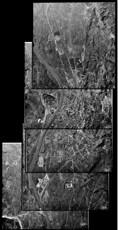
Figure 2: Typical strip of historic aerial reconnaissance photos for Trento depicting a non-constant overlap of the images.
2. THE AVAILABLE DATA SETS
The aim of the project is to create a multi-temporal spatial database for the cities of Trento and Rovereto and their neighbouring areas in the province of Trentino. These two areas were selected as case studies because significant infrastructure and landscape changes were expected.
Heterogeneous datasets representing different time periods were collected and used:
Black and white historical aerial images (physical prints) for Trento (Fig. 2) and Rovereto acquired during reconnaissance flights dating back to the Second World War (WWII). These analogue photos were not supplied with camera calibration certificate - mandatory information for photogrammetric processing;
1 meter resolution black and white digital orthoimages for Trento and Rovereto derived from a photogrammetric flight in 1973;
0.5 meter resolution RGB digital orthoimages for Rovereto produced from a photogrammetric flight in 2005;
0.5 meter resolution RGB digital orthoimages for Trento produced from a photogrammetric flight in 2009;
1 meter DSM and Digital Terrain Model (DTM) from aerial LiDAR data collected in 2006.
The WWII photos needed to be processed and geo-referenced in order to produce orthoimages comparable with the other available datasets. A set of eight vertical images for Trento and five for Rovereto were selected for processing (Table 1). To achieve a complete stereo coverage for Trento (from the northern to the southern part of the city) two different sets of aerial photos were selected.
Trento Rovereto
Numb. used photos 6 2 5
Possible camera K-17 K-17 K-17 Image format 9x9 in 9x9 in 9x9 in Date of flight 24/4/1945 29/4/1945 29/4/1945 Possible focal length 609.6 mm 609.6 mm 609.6 mm Approx. scale 1:13 000 1:12 500 1:12 500 Approx. GSD 0.2 m 0.2 m 0.2 m Image overlap ca 60% ca 60% ca 60%
Table 1: Historical images (1945) used in the project.
2.1 The WWII reconnaissance imagery
The oldest sets of historical aerial images belong to a repository of photographs acquired during WWII by the Royal Air Force (RAF) and United States Air Force (USAF) airplanes. Following air raids, reconnaissance flights were conducted to ascertain impacts of bombing missions.
During WWII, fighter planes such as the British Spitfire, the Mosquito, the American P-38 Lightning and P-51 Mustang were adapted for photo reconnaissance. These airplanes were stripped of weapons and painted in sky camouflage colours for making it difficult for them to be recognised by the anti-aircraft artillery. Additionally, the planes’ original engines were modified to ensure good performance at very high altitudes, which also helped prevent them from being intercepted. To fly at such high altitudes required the employment of very long focal length and the development of a camera warming system. Various types of medium and large-format cameras were used and arranged in different configurations (both vertical and oblique) to ensure wide ground coverage (Leoni & Marchesoni, 1997). Most of the aerial cameras had vacuum backs with a retractable pressure plate and a vacuum piston that kept the film flat and fixed in the focal plane during exposures.
Massive air raids were conducted over Trento and Rovereto between 1943-1945 to destroy landline communication and sources of energy that supported Nazi and Fascist armies (Leoni & Marchesoni, 1997). During this time, typically before and after the bombing missions, more than 1000 vertical and oblique photos were taken. These WWII images are available as contact prints from the original historical films provided by the American NARA (National Archives and Records Administration) and London and Keele University archives. The prints from both vertical and oblique images were supplied with neither camera certificate nor flight information. This lack of information about the camera, lens, etc. along with the photographic product (i.e., contact print from historical films) posed several challenges following a rigorous photogrammetric workflow.
.
a) b)
c)
d)
Figure 3. a) Fiducial marks visible on the used historical images, partially visible and with different forms. b) The coordinate system is defined on the historical photos assuming the geometrical centre of the fiducial marks as principal point: the same point was used to crop the images to the same fixed size. C) and d) Comparison of the radiometric and geometric resolution between historical (c) and actual (d) images. The actual image (2009) was resampled to have the same GSD of the oldest photo (1945).
3. PROCESSING OF THE HISTORICAL IMAGES
The conventional photogrammetric pipeline for orthoimage generation requires digital photos to be rectified using a suitable DSM in order to remove the perspective effects in the images. The DSM can be either generated from the same images or obtained from other sources (e.g., LiDAR data, previous aerial or satellite images) if the terrain in the area of interest is not significantly changed. In both cases, however, interior and exterior orientation parameters of the images are required. The processing of historical images is generally done with manual procedures, in particular the image triangulation and segmentation/classification steps. Redecker (2008) highlights the main reasons that affect the photogrammetric processing of historical aerial photos: (i) inaccuracy or total lack of meta-information about inner orientation (focal length and coordinates of fiducial marks) and additional (i.e., distortion) parameters; (ii) missing specifications about the flight mission (especially flying height); (iii) poor radiometric image quality (haze, image darkness, non-uniform luminosity); (iv) distortions caused by roll and pitch due to sudden movements of the plane; (v) improper transport or storage procedures of the film (humidity, temperature, etc.) and (vi) inaccurate processing of original films or hardcopies in field laboratories.
Prior to the 1940’s, there were no standard calibration procedures for aerial cameras and consequently calibration certificates are generally not available for the oldest historical aerial imagery (Luman et al, 1997). Moreover usable fiducial marks are often difficult to be identified in the photographs: identifiable points or features appear as slightly different shapes or are not visible at all (Fig. 3a). Therefore assumptions are often necessary, introducing some errors in the processing pipeline. Additionally, the image triangulation step necessitates a sufficient number of ground control points (GCPs). This operation often poses a significant problem as it can be difficult to identify present-day “stable” and unchanged points or features in a landscape (e.g., building corners, bridges, junctions of land parcels), that can be matched to the historic photos. Another challenge posed by historical imagery is that the automatic extraction of DSMs with image matching algorithms can deliver unsatisfactory results (spiky surface models) resulting from un-modelled distortions, errors in the interior orientation parameters and/or low radiometric quality. If this is
the case, the production of digital orthoimages from historical aerial imagery can be achieved employing a contemporary DTM instead of generating the DSM using the historical images. A faster, but less rigorous method, to geometrically correct historical photographs and produce orthoimages can be done by applying a polynomial transformation (Luman et al., 1997; Merler et al., 2005). This procedure can lead to inaccurate registration (i.e., measurement errors up to a few meters); however, it may be sufficient for revealing landscape changes at macro and medium scales (e.g., identifying land use changes such as forests to farms or rural areas to urban areas).
3.1 Recovering approximate calibration information
As specific information was unavailable, it was necessary to use proxy data to recover the approximate calibration information. After the USA entered into WWII, many reconnaissance aircraft were equipped with the Fairchild camera (Redweik et al., 2009). The dimensions of the available prints and forms of the fiducial marks suggest that the original film format was 9x9 inches and the camera employed was the K-17. The fiducial marks consist of four half-arrows in the middle of the image sides and appear as two different sizes. The pair of bigger half-arrows indicates the flight direction (Redweik et al., 2009). This reconnaissance and mapping camera for vertical and oblique aerial photos could be fitted with Bausch and Lomb Metrogon lens of 6", 12" and 24" focal length (Redecker, 2008).
3.2 Digitizing the historical repository
Considering the poor resolution of historical photographs, high- end desktop scanners can be used for digitizing the hardcopies (Redecker, 2008). It was proved that with a suitable calibration procedure, desktop scanners can be successfully used for cartographic applications and orthophoto production (Baltsavias, 1994; Mitrovic et al., 2004). For our task, the Epson Expression 1640XL desktop scanner was employed. To preserve as many details as possible in the imagery, the prints were scanned at 1600dpi geometric resolution (i.e., 16 micron pixel size) and a 16 bit radiometric resolution. To evaluate and reduce any possible distortions introduced by the scanning operation, a reference image, available in both digital (scanned with a photogrammetric scanner) and hardcopy (contact print) forms, was used.
Location N°. of
Table 2: Results of aero-triangulation of historical images.
The print was digitized with the Epson Expression 1640XL scanner and then rectified with respect to a softcopy reference image applying a second order polynomial function. A final RMSE of 1.25 pixel (i.e., 18.75 microns) was obtained and all the scanned historical images were then rectified using the same estimated polynomial correction.
3.3 Collecting 4D ground control points
As mentioned, GCPs are necessary to determine approximate interior parameters of the historical images, e.g., by means of a Direct Linear Transformation DLT approach (Abdel-Aziz & Karara, 1971), and for the image triangulation phase with a bundle block adjustment. The identification of reference points visible in both the historical and more recent aerial images can be very difficult, and thus often inaccurate and unreliable. Two problems that commonly affect point or feature identification are landscape changes and the low radiometry and resolution of historical data (Fig. 3c and Fig. 3d). The least expensive solution is the use of geo-referenced maps or orthoimages to derive planimetric coordinates and DSM or trigonometric fix points for altimetric coordinates (Redecker, 2008). The more rigorous and reliable method consists in collecting GCPs that are also identifiable in the historical images. In this project, a hybrid method was used. GCPs were measured using topographic surveying methods, collecting 20 object points located primarily on roofs of historical buildings or edges of monuments. To analyse the accuracy of the results, some checkpoints were identified using the current available DSM.
3.4 Recovering the interior orientation of the images
For the transformation between pixel and photo coordinates, a virtual coordinate system for the interior orientation was constructed. This was accomplished by measuring the four fiducial marks visible on a scanned image selected as reference, assuming the geometrical centre of the marks as principle point and origin of the coordinate system (Fig. 3b). The coordinates of the fiducial marks with respect to the chosen principal point were then used to compute the six-parameter affine transformation for each digitized historical image. Moreover, the same sensor format was ensured for all the scanned images by cropping of a fixed image size with the principal point at its centre. Then the DLT method was applied for assessing the most likely nominal focal length for the flights over Trento and Rovereto. The results confirmed that both flights were performed with a 24" (609.6mm) focal length lens, as previously assumed.
3.5 Recovering the exterior orientation of the image block
The block geometry of images does not guarantee a strong camera network configuration. In this project, there was a non-optimal block configuration because the photos came from a single flight strip (no sidelap), sometimes with less than 60% overlap between successive photos (Fig. 2). Moreover the use of a tele-lens resulted in very low intersecting angles between
optical rays ranging in average from 10 degrees (for stereo-images) to 16 degrees (considering three intersecting image rays). Other researchers have shown that despite a non-optimal block configuration, incorporating additional parameters in triangulation can help to account for unknown geometric errors caused mainly by the lens but also by other non-modelled distortions (e.g., age, maintenance conditions, scanning) (Redecker, 2008; Redweik et al., 2009). Based on this previous work, the image orientation was performed with a standard bundle block adjustment; however, only the exterior parameters were solved, because the adjusted values of the interior parameters were not statistically significant. The results of the aero-triangulation are shown in Table 2. The expected precision was calculated considering that the actual measurement precision of the imagery (i.e., possibility of resolving details and visible features, Fig. 3 c and d) is about 3-5 pixels). Incorporating additional parameters (radial and tangential distortions) did not produce meaningful improvements in terms of residuals on the checkpoints.
3.6 DSM generation, ortho-rectification and mosaicking
Once the image blocks were oriented, the DSMs for Trento and Rovereto were automatically extracted using image matching algorithms. Different algorithms were tested, commercial and open-source. To obtain a satisfying compromise between smoothing effect and signal to noise relation, typical windows of 21 x 21 pixels in rural regions and 13 x 13 pixels in urban areas were used. As expected, the resultant surface models had some deformations and spikes. In order to improve the quality of the DSM, some manual editing was necessary.
To ortho-rectify and mosaic the two sets of historical images (one for Trento and the other for Roverto), the strict photogrammetric procedure was applied. Despite some model distortions, the historical orthoimages overlaid on the more recent orthoimages with a maximum discrepancy of few meters, in particular in correspondence of relevant landscape discontinuities. Historical orthoimages were also generated using the current DTM. The differences between the images obtained with the two different elevation models (one generated using the historical images and the other generated from modern DTM) were not noticeable.
4. ANALYSES OF LANDSCAPE CHANGES
To identify landscape changes, it is first necessary to identify some features and areas of interest. Normally in urban environments, these features are buildings, roads and vegetation. Manual image interpretation techniques are always more reliable although time consuming. Automatic or semi-automatic techniques are desirable although the radiometric quality of historical images is often not satisfactory for such approaches. The orthoimages generated from the reconnaissance aerial photos (WWII) were compared to the orthoimages dating back to the 1970s and 2000s in order to reveal changes in landscape and urban expansion that has occurred over the past 60 years.
Trento 1945 Trento 1973 Trento 2009 Trento 1945-2009
Rovereto 1945 Rovereto 1973 Rovereto 2005 Rovereto 1945-2005
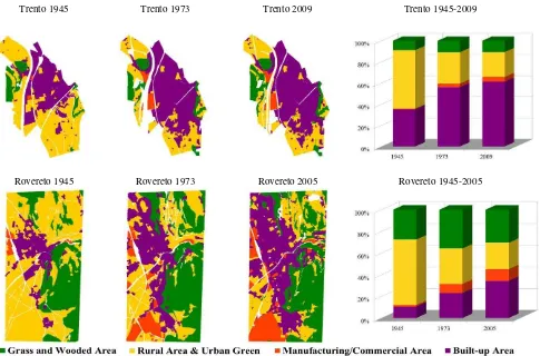
Figure 4: Digitization of multi-temporal orthophotos showing dominant landscape changes. The white areas on the GIS layers are rivers or roads. In the right column, land cover and land use analyses for Trento and Rovereto cities are summarised. The four landscape categories are expressed as percentage of the investigated area (ca 8sqkm for Trento and ca 12sqkm for Rovereto).
To test the utility of the proposed methodology and resultant data layers, specific features were manually digitized as GIS layers and then classified into four macro landscape categories (adapted from Robinson et al., 2004):
built-up or urban areas;
manufacturing and commercial areas; rural area and urban green;
grass and wooded areas or wild lands.
The final result was a temporal GIS developed using data acquired from the multi-temporal image. This temporal GIS is used to identify, document and analyse transformations in land cover and land use for the region of interest (Fig. 4). Diagrams with relative changes with respect to the entire investigated area were also computed. The analyses show that significant urban growth has occurred in the post-war years. In particular, they indicate that in the southern part of Rovereto, an important industrial zone was built and that, generally speaking, while urbanization has increased, surprisingly the amount of forested land has also increased, most likely due to a decrease in the use of firewood.
5. FURTHER PRODUCTS: CITY AND BUILDINGS MODELLING
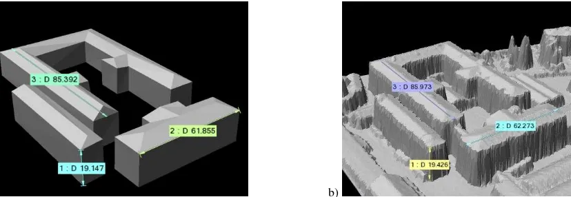
The repository of WWII era historical images also comprises a set of oblique aerial photos (tilt angles of about 45°). To demonstrate the utility of such data and explore the possibility to perform further 3D studies and analyses, an oblique image of Rovereto was processed following the steps described in section 3. For this test, the oblique image was incorporated into the
bundle adjustment with the other vertical images and used to manually model old buildings (still existing and not modified). The use of Pictometry-like oblique images allowed the derivation of a more accurate 3D reconstruction due to the higher intersecting angle among homologous optical rays (Fig. 5a). In order to assess the accuracy of the obtained photogrammetric model, a geometric comparison with the current LiDAR data was performed (Fig. 5b). The same distances were measured on both models—the results indicated maximum differences of ca. 50cm. This test demonstrates that integrating vertical and oblique aerial imagery is suitable for historical 3D city modeling and to reveal changes and transformation in buildings.
6. CONCLUSIONS
This paper presented a 4D modeling approach that uses multi-temporal and historical aerial images to derive spatio-multi-temporal information for scenes and landscapes. The case study in the Trentino region showed that the digital processing of archival images offers a method for researchers to identify changes over time in cities and across landscapes. The results indicate that processing historical aerial images presents many challenges, in particular for actual automated procedures, and the need to correctly recover unknown parameters in order to avoid substantial geometric errors. In case of image blocks with large overlap and a better geometry, a self-calibrating bundle adjustment with different sets of additional parameters can be employed in order to minimize all the possible errors and deformations. A strict photogrammetric processing, like the one
a) b)
Figure 5. 3D photogrammetric modelling of buildings from both vertical and oblique historical images (a). The respective actual LiDAR-based building model (b). The differences of the main building lengths are in the decimetre level.
applied in this work, allows researchers to derive statistical values to evaluate the quality of the data processing. Moreover, the use of oblique photos can improve the accuracy and quality of the processing pipeline and allows the geometric 3D modeling of historical buildings. The change detection analysis employed in this paper has provided intriguing results, e.g. indicating that the city of Rovereto is now almost 25 times larger (in 2005) than 6o years ago. Notably, the grasslands and forests surrounding both Rovereto and Trento remain intact despite rapid urbanization. Additionally, the change detection also indicates large-scale construction and expansion along the Adige River and main communication lines. These findings raise many questions about governmental policies, land use, and broader cultural changes that can serve as a springboard for researchers in many disciplines such as urban planning, history, and geography.
ACKNOWLEDGMENTS
The work was funded by Fondazione CARITRO (Trento, Italy) within the project MEM3D. The authors are really thankful to the Autonomous Province of Trento (Italy) for the WWII image data as well as to Dr C. Furlanello and Dr S. Merler (MPBA-FBK Trento, Italy) for the useful discussions regarding the historical images over the Trentino region.
REFERENCES
Abdel-Aziz, Y.I., Karara, H.M., 1971. Direct linear transformation from comparator coordinates into object space coordinates in close-range photogrammetry. In: Proceedings of
the ASP Symposium on Close-Range Photogrammetry, Falls
Church, VA, pp. 1-18.
Baltsavias, E., 1994. Test and Calibration Procedures for Image Scanners. International Archives of Photogrammetry and
Remote Sensing, Vol. 30(1), pp. 163 – 170.
El-Hakim, S., Lapointe, J.-F., Whiting, E., 2008: Digital reconstruction and 4D presentation through time. Proc.
SIGGRAPH
Leoni, D., Marchesoni, P., 1997. Lo sguardo del sapiente glaciale. La ricognizione aerofotografica anglo-america sul
Trentino (1943-1945), 155 pages. ISBN 88-7197-028-4.
Luman, D.E., Stohr, C., Hunt, L, 1997. Digital Reproduction of Historical Aerial Photographic Prints for Preserving a Deteriorating Archive. Photogrammetric Engineering &
Remote Sensing, Vol. 63, No.10, pp. 1171-1179.
Merler, S., Furlanello, C., Jurman, G., 2005. Machine learning on historical air photographs for mapping risk of unexploded bombs. 13th International Conference on Image Analysis and
Processing (ICIAP2005), Lecture Notes in Computer Science,
Vol. 3617, pp 735-742.
Mitrovic, M., Cvijetinovic, Z. , Mihajlovic, D., 2004. Procedures and Experiences on Using Desktop Scanner for Orthophoto Production. IAPRS&SIS, Vol35(B1), Istanbul, Turkey, pp. 7.
Patias, P., Kaimaris, D., Stylianidis, E., 2011: Change detection in historical city centers using multi-source data: the case of historical center of Nicosia – Cyprus. Proc. 23rd Int. CIPA
Conference, Prague, Czech Republich, 6 pages.
Ratcliffe, I.C., G.M. Henebry, 2004: Using declassified intelligence satellite photographs with Quickbird imagery to study urban land cover dynamics: a case study from Kazakhstan., Annual Proceedings ASPRS, Denver CO., paper 198: 1-10.
Redecker, A.P., 2008. Historical aerial photographs and digital photogrammetry for impact analyses on derelict land sites in human settlement areas. IAPRS&SIS, Beijing, China, Vol. 37(B8), Beijing, China, pp. 5-10.
Redweik, P., Roque, D., Marques, A., Matildes, R., Marques, F, 2009: Recovering Portugal aerial images repository.
ISPRS&SIS, Vol 38(1-4-7/W5), Workshop 2009
High-Resolution Earth Imaging for Geospatial Information, Hannover, Germany, on CD-Rom, pp. 7.
Robinson, L., Newell, J.P., Marzluff, J.M., 2004: Twenty-five years of sprawl in the Seattle region: growth management responses and implications for conservation. Landscape and
Urban Planning, Vol. 71, pp. 51–72.
Schindler, G., 2010: Unlocking the urban photographic record
through 4D scene modeling. PhD thesis, Georgia Tech Univ.,
137 pages.
Stefani, C., Busayarat, C., Renaudin, N., De Luca, L., Véron, P., Florenzano, M., 2011: An image-based approach for the architectural modeling of past states. IAPRS&SIS, Vol 38(5/W16), on CD-rom, 8 pages
Vizzari, L., 2011: Spatio-temporal analysis using urban-rural gradient modelling. Proc. ICCSA 2011, Murgante et al. (Eds.), LNCS 6782, Part I, pp. 103-118.