APPLICATION OF GEOGRAPHIC INFORMATION SYSTEM AND REMOTESENSING
IN EFFECTIVE SOLID WASTE DISPOSAL SITES SELECTION IN WUKRO TOWN,
TIGRAY, ETHIOPIA
A.A., Mohammedshum,*a, M.A., Gebresilassiea, C.M., Rulindaa, G.H., Kahsaya, M.S., Tesfayb
a
Institute of Geo-Information and Earth Observation Sciences (IGEOS), Mekelle University, Mekelle, Ethiopia (* [email protected])
b
Land Resources Management and Environmental Protection (LaRMEP), Mekelle University, Mekelle, Ethiopia
KEY WORDS: GIS, Remote Sensing, Solid waste disposal, Wukro town
ABSRACT
Identifying solid waste disposal sites and appropriately managing them is a challenging task to many developing countries. This is a critical problem too in Ethiopia in general and in Wukro town in particular. The existing site for Wukro town is not sufficient in its capacity and it is damaging the environment due to its location, and the type of waste dumped, while the surrounding area is being irrigated. Due to the swift expansion and urbanization developments in Wukro town, it badly needs to develop controlled solid waste dumping site to prevent several contamination problems. This study was conducted first, to assess the existing waste management strategies in Wukro town; and second, to find out the potential waste disposal sites for the town, using GIS and Remote Sensing techniques. The study exploited the Multi-Criteria Evaluation (MCE) methods to combine necessary factors considered for dumping site selection. The selected method also uses various geographical data including remote sensing data, with GIS spatial analysis tools. Accordingly, site suitability maps for each of the factors were developed in a GIS environment. Results indicate that 12 dumping sites were appropriate and they were further ranked against their suitability in terms of wind direction, proximity to settlement area and distance from the center of the town. Finally, two sites are the best suitable for dumping site. This study indicated that the application of Geographic Information System and Remote Sensing techniques are efficient and low cost tools to study and select appropriate dumping site so as to facilitate decision making processes.
1. INTRODUCTION
Selecting and managing appropriate solid waste dumping site is one of the challenging problems in developing countries, due to the lack of proper solid waste management system and the type of waste thrown to the environment. The practice of direct dumping of waste into water bodies, open and abandoned lands without proper treatment leads to serious environmental pollution and health-related problems. The rapid growth of the world population and the urbanization processes are making the non-renewable resources to be in shortage and the disposal of effluent and toxic waste done indiscriminately. The current global trend of waste management problems stems from unsustainable methods of waste disposal, which is ultimately a result of inadequate planning and implementation (Abbas etal., 2011).
According to The United State Environmental Protection Agency (USEPA, 2005) Solid waste is defined as any garbage, refuse, sludge from a waste water treatment plant, water supply
treatment plant or air dried materials, including solid, liquid, semi-solid or contained gaseous materials resulting from industrial, commercial mining and agricultural operations and from community activities. The effectiveness of solid waste disposal depends upon the selection of proper site which is mainly impacted by economical and environmental issues. Each city produces tones of solid wastes daily from households, hospitals, industry, offices, market centers etc.
(Zamorano etal., 2008) described landfill site selection as a complex process involving social, environmental and technical parameters as well as government regulations which requires the processing of a massive amount of spatial data. In addition, site selection of new landfills for municipal solid waste disposal is a great concern of urban government around the world as old landfill sites are bring filled-up and demanded for new sites is increasing (Hasan etal., 2009).
Geographic Information System (GIS) and Remote Sensing are such computerized systems that can be integrated to get optimal solutions for efficient and effective solid waste management planning. On the one hand, GIS is a system that helps to capture, store, analyze, manage, and present data that are linked to location(s). It is the merging of cartography computer aided design/drafting (CAD) systems, statistical analysis tools, and database technology that help informed decision making. It is a tool that allows users to analyze spatial information, edit data, maps, and present the results of any spatial and non-spatial based analysis. Studies such as ((chang etal., 2007), (Sumathi etal., 2008) and ( Nishanth etal., 2010)) described that the role of GIS in solid waste management is very important on identifying suitable location for landfill. As (Devendra, 2012) further stated, with the proper use of technologies such as GIS, management of municipalities and city administrators solve their problems easier and in more effective way. On the other hand, Remote sensing is a small or large-scale acquisition of information of an object or phenomenon, by the use of either recording or real-time sensing device(s) that are wireless, or with no physical or intimate contact with the object (Lillesand etal., 2004). Its multispectral capability provides appropriate contrast between various natural features where as its repetitive coverage provides information on the dynamic changes taking place over the Earth surface and the natural environment (Adeofun etal., 2011).
This study stemmed from the problem of uncontrolled population growth and urban sprawl; increase in solid waste generation observed in many towns and cities across Ethiopia and the developing world in general. The existing site for one of the towns in the Tigray Regional state of Ethiopia, Wukro town is not sufficient in its capacity and it is damaging the environment due to its location, and the type of waste dumped, while the surrounding area is being irrigated land. Due to rapid expansion and urbanization developments in the town, it needs to develop controlled solid waste dumping site to prevent contamination problems.
Earlier studies have shown that application of Remote Sensing in combination with GIS analytical tools have significant importance for landfill site selection (Ostir etal., 2003) and (Zamorano etal., 2008). To select a potential waste disposal site different input criteria must be included; for instance, in previous studies such as ((Ahmed etal., 2011), (Moeinaddini etal., 2010) and (Al-jarrah,Abu-Qdaia, 2006)), used surface water, ground water, faults, land use, land cover, permeability of soil, depth of soil and slope as criteria for land fill site selection. In addition GIS spatial operations were also utilized to select the dumping sites; for instance, digitizing, buffering, overlay, query and network analysis (Sani etal., 2010) as sited in (Adeofun etal., 2011). The objective of this research was to assess the present waste disposal management in the town and contextualize the criteriaso as to fit to the specific environment. Therefore, by combining some of the above criteria and other relevant criteria to the specific location, we tried to find out the potential waste disposal sites using GIS and Remote sensing acquired from Ethiopia Metrological Agency (EMA), the average rainfall of the town is about 606.4 mm per year; minimum mean monthly temperature of the region ranged between 80C to 12.30C; while the maximum mean monthly temperature varies between 18.60C to 28.80C; throughout the year in the last ten years. To assess the present waste disposal management in the town, we apply an interview and questioner in order to collect primary data from residents of the town. In addition, we include information from Wukro municipality and environmental protection offices, about the locations and conditions of the existing landfill depot site.
In this research land use/land cover, soil, geology and slope of the study area were used as suitability factors. Moreover, proximity from road and proximity from rivers were also considered as constrains. All the factors and constrains were internally classified into five classes (very high, high, moderate, low and very low) with values ranging from 5 to 1, where the value of 5 denotes the most suitable and value 1 denotes the least suitable, for all factors and constrains considered. Weights for each class of criteria were derived using Analytic Hierarchy Processes (AHP) methods in IDRISI software. AHP is one of the most commonly used multi criteria decision analysis tools. This tool is applied in site selection process as it assists the decision making process by allowing decision makers to organize the criteria and alternative solutions for a decision problem in a hierarchical decision model (Eldrandaly etal., 2005). The method uses the expert preferences for comparing the classes, and prepares a matrix table. All factors considered for waste disposal site selection was analyzed based on the Table 1.
Table 1: Attribute scores and weights for the maps used in the waste disposal site selection
Note: (5=very high, 4= high, 3= moderate, 2= low and 1= very low)
roads were converted to raster files and separate datasets were created using weight and rank. For the analysis all the raster datasets for different layers having different score were overlaid and the scores of each composite class were added using raster calculator tool of spatial analyst extension of ESRI ArcMap.
3. Result and Discussion
3.1 Solid Waste Management System in Wukro Town
The first objective of the research was to assess the present waste management strategies in Wukro town. Result of the questioner and interview showed that the municipal of the town together with the land administration office selected and prepared the existing dumping site based on the criteria such as distance from town center and rivers and geological condition of the area. This dumping site was planned to serve for 10 years, but it could not serve beyond 5 years. In the town solid waste is collected from residences, institutions and asphalt roads, transported to one damping site and separated according to certain types. To do this the office gave contract to two associations for collecting and discriminating the solid wastes based on several types. The collectors gather the waste from houses once per week and from others (institutions) per two weeks and transport it to dumping site using horse carts.
As the town is becoming a conference center and departure station to different tourist attraction areas of the regional state, the municipality gives great concern to beatification and solid waste disposal and management. This basic service is currently receiving wide attention in many towns of Ethiopia. This is mainly because solid wastes that are generated in most towns of Ethiopia are not appropriately handled and managed. However, it is possible to minimize and solve these problems through strictly planning and implementing different municipal solid waste management components. According to ((Leao etal., 2010) and (Zafare and Alappat, 2005)), if the site is not suitably sited and managed, it can lead to serious contamination to the environment, for instance ground water, surface water and air pollution, that have negative effect and considered as threat to residents. However, the negative impacts from landfill can be minimized through selecting an appropriate site, which minimize potential environmental impact (Zain etal., 2009) and GIS and RS techniques are effective for the purpose.
3.2 Waste Disposal Sites Suitability Analysis
The second objective of the study was to find out the potential waste disposal sites using GIS and Remote sensing techniques. Suitability results of the inputs were as followed for example, slope suitability was classified into five classes. However, suitability of river, road and soil was classified into four classes. In addition, suitability of land use/cover and geology was classified into three classes. Based on the weight assigned for each class, slope, geology, soil, land use/cover, river and road map of the town was standardized and suitability map was prepared. The factor maps were combined according to their importance; Land use/cover factors were more importance to have overall suitability map. studies such as ((Ahmed etal.,
2011), (Moeinaddini etal., 2010) and (Al-jarrah and Abu-Qdaia, 2006)), used like, surface water, ground water, faults, land use, land cover, permeability of soil, depth of soil and slope as criteria for land fill site selection. Final suitability map showed that the study area is classified into four highly suitable, moderately suitable, marginally suitable and restricted (Fig.2).
Figure 2: Dumping Sites Suitability Map of Wukro town
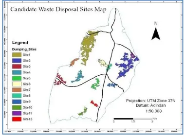
3.3 Evaluating Candidate Waste Disposal Sites
Finally the analysis resulted in several different potential sites. The sites with small areas are economically not feasible and hence excluded from further analysis. As indicated on Fig. 3, twelve candidate dumping sites were selected. In addition, suitable sites were evaluated against other criteria mainly wind direction, distance from nearby settlements and distance from the center of the town were determined for each candidate site. Finally, two sites (site 10 and 12 of Fig 3.) are indentified as the best suitable dumping sites for the town. Finally, the results of our study, i.e. the two final sites were evaluated by expert (environmentalist) from the town and both of them were validated, approved and ranked as site 12 the best and site 10 the next. Accordingly, they are considered for final decision with regard to their approval for construction by the municipality authorities
4. CONCLUSIONS
In this study, the application of Geographic Information System and Remote Sensing data were used to study potential solid waste disposal site. The study used mainly the Multi-Criteria Evaluation (MCE) method to combine all the factors maps considered for dumping site selection process. The method used various geographical data with GIS spatial analysis tools, accordingly, site suitability maps for each of the factors considered were developed in a GIS environment. The factors maps were combined according to their importance as a result, Land use/cover factors were more importance to have overall suitability map. And it was indicated that final suitability map showing 19.53% of the study area is highly suitable. In addition, 32.92%, 32.64% and 14.91% of the total area is moderately suitable, marginally suitable and unsuitable (restricted) respectively and 12 candidate dumping sites were selected. Potential sites (site10 and 12) are the first two most suitable site in terms of wind direction, nearness to the settlement and their distance from the center of the town. This study indicated that the application of GIS and Remote Sensing techniques are efficient and low cost tools to study and select appropriate dumping site so as to facilitate decision making processes. Finally, hydrological factors influencing dumping site selection are recommended for future work.
5. ACKNOWLEDGEMENTS
The authors extend their gratitude to the Institute of Geo information and Earth Observation Sciences, Mekelle University for the given opportunity to accomplish this research study. Last but not least, we thank NORAD III project, Mekelle University for the financial support.
6. REFERENCES
Abbas, I.I, Nai’ya, R and Arigbede, Y.A, 2011. Use of remote sensing and GIS in effective and efficient solid management planning (a case study of Samara, Zaria, Nigeria) Research Journal of Earth and Planetary Studies 2:046-052.
Adeofun, O, Achi, A, Ufoegbune.C.Gbadebo,M and Oyedepo,A, 2011. Application of Remote sensing and Geographic Information System for selecting Dumpsites and Transport Routes, in proceeding of the Environmental Management Conference, Federsl University of Agriculture, in Abeokuta, Nigeria.
Ahmad, A, Bayan.A and Akihiko, K, 2011. Using GIS based weighted linear combination analysis and remote sensing techniques to select optimal solid waste disposal sites within Mafraq city, Jordan, Journal of Geographic Information System, 3:267-278.
Al-Jarrah, O. and Abu-Qdais, H, 2006. Municipal solid waste landfill siting using intelligent system, Waste Management, 26:299-306.
Chakhar, S. and Mousseau, V, 2008. GIS-based multi criteria spatial modeling generic framework, International Journal of Geographic Information Science, 22:11, 1159- 1196.Taylor & Francis.
Chang, N.B, Parvathinathan, G, Breeden, B.J., 2007. Combining GIS with fuzzy multi criteria decision-making for landfill siting in a fast growing urban region, Journal of Environmental Management, 1:11,1-15.
Devendra.P, Selection of prospective Waste Disposal Sites for Gondia Municipal Council of Maharashtra, India. International Journal of Life Sciences Biotechnology and PharamResearch 3(1):2250-3137.
Eldrandaly, K., Eldin, N., Sui, D., Shouman,M. and Nawara, G.,2005. Integrating GIS and MCDM Using COM Technology, the International Arab Journal of Information Technology, 2: 2,162-168.
Hasan, R.M., Tetsuo, K.and Islam, A.S., 2009. Landfill demand and allocation for municipal solid waste disposal in Dhaka city-an assessment in a GIS environment, Journal of Civil Engineering (IEB), 37:2,133-149.
Karadimas, N.V., Loumos, V and Mavrantza O., 2004. Quality of Service Ensuring in Urban Solid Waste Management, in Proceeding of the 2nd International IEEE Conference on Intelligent Systems, Varna, Bulgaria, 288-292.
Leao, S., Bishop, I., Evans, D., 2010. Assessing the demand of solid waste disposal in urban region by urban dynamics modeling in a GIS environment, Resources, Conservation and Recycling, 33:289-313.
Lillesand, T. M., R. W. Kiefer, and J. W. Chipman 2004. Remote Sensing and Image Interpretation, Fifth Edition. Wiley, New York, N.Y., 784p.
Moeinaddini, M., Khorasani, N., Ali, D.A., Darvishsefat, A., Zienalyan, M., 2010. Siting MSW landfill using weighted linear combination and analytical hierarchy process (AHP) methodology in GIS environment (case study: Karaj), Waste Management, 30:912-920.
Nishanth, T., Prakash, M.N. and Vijith, H., 2010. Suitable site determination for urban solid waste disposal using GIS and Remote sensing techniques in Kottayam Municipality, India, International Journal of Geomatics and Geosciences, 1:2,197-209.
Oštir, K., Veljanovski. T., Podobnikar.T. and Stančič, Z., 2003. Application of satellite remote sensing in natural hazard management: the Mount Mangart landslide case study, International Journal of Remote Sensing, 24: 20, 3983-4002.
Sumathi, R.V., Natesan, U., Sarkar, C., 2008. GIS-based approach for optimized siting of municipal solid waste landfill, Waste Management, 28: 2146-2160.
United Nations Development Programme (UNDP), 2004. Municipal Solid Waste Management in Developing Countries: A policy Framework. Geneva. Technical paper, 12, Geneva.
United State Environmental Protection Agency (USEPA) 2005. Municipal Solid Waste Basic Facts, Retrieved 23rd March, 2011 from http://www.epa.gov/epaoswer/nonhw/ muncpl/reduceh.htm.
Zafar, M. and Alappat, B. J.,2005 Landfill Surface Runoff and Its Effect on Water Quality on River Yamuna, Journal of Environmental Science and Health, Part A, 39:2,375-384.
Zain, T., 2009. Some aspects of solid waste disposal site selection: the case of Wadi Madoneh, Jordan, International Journal of Environmental Studies, 66: 2, 207-219.