This toolkit was written by: Bauke de Vries
Huib Haccoû Theo de Bruijn Daan Stortelder
Of Saxion University of Applied Sciences
Foreword
This toolkit is one of the main deliverables of the Sustainable Urban Fringes (SURF) Project, part of the Interreg IVB North Sea Region Programme. The project brought together partners and experts from across the North Sea Region (2009 – 2013) to exchange information and develop a common approach towards the sustainability of urban fringe areas. The following partners have been engaged in the project:
• Aberdeen City Council
• School of the Built Environment at Leeds Metropolitan University • City of Bradford (Airedale Partnership)
• Norfolk County Council • City of Enschede
• Centre for Urban and Environmental Development at Saxion University of Applied Sciences • City of Almelo
• City of Hengelo
• Province of East Flanders • Province of West Flanders • City of Hamburg
• Municipality of Harryda • Province of Antwerp
The toolkit brings together the tools that the partners have employed during the SURF project. It is not meant to be complete but offers, we hope, an inspiring collection of promising and effective tools to stimulate sustainable development in urban fringe areas. The toolkit itself consists of three parts. After an introduction in which the approach that SURF took is explained, the main section comprises a description of the tools. After that a brief reflection can be found.
Acknowledgements
The toolkit is the result of the work of many people. In addition to the authors, all partners in the SURF project contributed to the toolkit and commented on draft versions. Without their input this toolkit would not have been realised.
Feedback
The toolkit describes the tools and the lessons learned to date in 2012 after three years’ work on the SURF project. Many of the partner projects are just at the start of the realisation phase, which implies that a lot more will be learned in the next couple of years about the effectiveness of the tools in use. Other organisations are also working on sustainability in the urban fringes and are learning valuable lessons. Everyone with experiences which can contribute to a more complete and elaborated toolkit 2.0 is more than welcome to share their ideas. You can use the contact information below to share your ideas, or join the Linkedin group on Sustainable Urban Fringes.
www.sustainablefringes.eu
Saxion University of Applied Sciences
Table of Contents
Part 1: Introduction 6
Part 2: The tools used within SURF 11
Tool category: Building Networks 13
Stakeholder participation in determining landscape quality objectives (Province of Antwerp, Belgium) 14
Open Space Audit (Aberdeen, Scotland) 17
Virtual Flythrough, Google Earth (Norfolk, England) 21
Integrating traditional and modern communication methods (Norfolk, England) 25
Inter-municipal Neighbourhood Forum (Free and Hanseatic City of Hamburg, Germany) 28
Regional vision development (Region of Twente, the Netherlands) 31
Green Knowledge Portal (Region of Twente, the Netherlands) 34
Cooperation between authorities and higher education (Province of West Flanders, Belgium) 37
Friends of Weusthag Foundation (Hengelo, the Netherlands) 40
Tool category: create synergy between different qualities 44
Regional Park (Free and Hanseatic City of Hamburg, Germany) 45
Gids Buitenkans (Enschede, the Netherlands) 47
Enterprise coaching (Almelo, the Netherlands) 51
Green space in business areas (Almelo, the Netherlands) 53
Regional branding (Province of West Flanders, Belgium) 56
Business engagement in Parish planning (Bradford, Worth Valley, England) 59
Rondje Enschede (Enschede, the Netherlands) 64
Provincial Quality Chamber (Province of East Flanders, Belgium) 67
Part 3: Reflection 70
Urban fringes are receiving more and more attention, given the transformational changes in both urban and rural areas plus the fact that both are becoming increasingly interwoven. A main driver for the increased attention on the urban fringe is the demographic change that many European countries are, and will be, experiencing in the coming decades. For a long time the urban fringe was a `temporary zone’ waiting for the next wave of urban expansion. In many cases it is no longer expected that this ongoing process of expansion will continue much longer. This gives the urban fringe a much more permanent character and calls for specific attention. In practice, this proves to be an important task, not only because of substantive issues but first and foremost given the often fragmented governance structures for the urban fringe.
The SURF project explored the diversity of government and governance structures. Sometimes the urban fringe is governed by a major city with suburbs, sometimes a few comparable cities form a region that controls the urban fringes, while in other situations a province takes the lead. In all situations, however, local and regional governments have to collaborate with other government layers, NGOs, citizens and the private sector.
Creating synergies
The urban fringe area is the zone between urban and rural areas, where urban and rural functions and qualities meet and interact. This interaction can have both positive results (synergy between the functions and qualities, added quality) or negative results (negative interference, loss of quality because of the interaction between different functions). An example of synergy is the presence of an attractive agricultural landscape that combines functions like recreation, biodiversity conservation, water management and employment creation. An example of negative interference is the presence of a polluting industrial site in the urban fringe zone, leading to depreciation and deprivation of neighbouring housing areas and farmland, resulting in a negative spiral. Local and regional governments are looking for a balanced mix of functions and qualities for the urban fringe, jointly with other governments, citizens and private organisations. This toolkit provides some examples of the tools they use in this respect.
The toolkit: aims and audience
Urban fringes present complex challenges to governments. As noted above, next to the substantive issues to be tackled, urban fringes are often prime examples of the complex patterns of overlapping governance and indeterminate boundaries, with diverse roles for both public and private actors. Within the context of the SURF project it was understood how regional and local authorities are dealing with the complex challenges in urban fringes. This toolkit brings together the most promising tools and approaches they have employed successfully.
The toolkit is not meant to be complete, nor does it address every possible local situation. It offers examples of sometimes innovative uses of tools and as such it is meant to give inspiration to local and regional authorities dealing with the complex challenges in their urban fringes. Included are descriptions of a tool, the context in which it is used, success and failure factors, and contact information to learn more in-depth from a tool.
Urban fringe areas
Within this toolkit, the urban fringe is not considered as an area with a very clear delineation. It starts in the urban area, where housing densities decrease and rural functions like food production and water management emerge. It ends in the rural area, where urban influences like housing and industry are no longer visible in the landscape. It should not be considered as a line, but as a zone with both rural and urban influences and a discussion about exact borders will not be fruitful in most situations. Sometimes it can start and end kilometres from the border between the urban and rural areas.
Throughout Europe, the urban fringe area can be considered as very important from the perspective of public policy. The specific situation in urban fringe areas differs from city to city and from country to country. Here are describe some features that can be distinguished in these areas, and some challenges urban fringes are dealing with:
• Differences and fluctuations in (expected) property value: land awaiting urban development raises prices, but in some regions a shrinking or stabilising population in combination with the financial crisis leads to a decrease
in the amount of land needed for urban expansion, which in turn leads to lower land prices.
• Lack of coherence in planning policy and regulations, potentially leading to a decline in spatial quality and loss of attractiveness of the area.
• Nevertheless in many places an attractive place to live, because of the proximity of both green space and urban facilities and functions; often offering spacious dwellings and estates endowed with cultural heritage.
• In contrast, sometimes a lack of identity: not rural, not urban, lack of specific cultural or regional identity, as a result of the lack of coherent planning and the diversity of functions.
• The zone where space-consuming urban facilities are concentrated: infrastructure nodes, wholesale facilities, industrial estates, city dumps, water purification plants.
• A zone where specific social and recreational facilities are concentrated: allotment gardens, public parks and green areas, sports facilities, riding schools, trails and footpaths.
• In contrast, it is also often perceived as a zone with limited connectivity between the urban and rural area; in many of the SURF partner areas there are slow means of transport: walking and cycling. This limits opportunities to access the urban fringe and to use it for recreation or economic functions.
• A change of functions as a result of local, regional, national and international developments: agricultural property becomes available for other functions; mono-functional world market agriculture is shifting towards
multifunctional urban agriculture with more attention on the local market. Farming is increasingly combined with other functions such as social and health care and recreation. Open areas for water retention are developed as a part of climate change mitigation policies.
• An area with specific environmental risks and opportunities: ‘urban’ water is contaminating clean rural water, landscape cluttering, risk of decrease in biodiversity in situations of deterioration. On the other hand there are specific opportunities for landscape, environmental and biodiversity improvements and for innovative applications in the field of environmental management. This can involve, amongst other things, functions like water retention and innovative sewage treatment technologies that produce energy and recover nutrients. The urban fringe can also play a crucial role in providing renewable forms of energy production, like wind,
Sustainable Urban Fringes
SURF was specifically focused on creating sustainable urban fringes. The tools in this toolkit (partly) reflect that focus. Within SURF, sustainability has been defined as a process through which integral, future-oriented quality is delivered. Next it is highlighted the main elements of this approach.
In the project approach SURF naturally followed the concept as it has been defined by the Commission Brundtland (1987): sustainable development means meeting the needs of present generations without jeopardising the ability of future generations to meet their own needs – in other words, a better quality of life for everyone, now and for generations to come. It offers a vision of progress that integrates immediate and longer-term objectives, local and global action, and regards social, economic and environmental issues as inseparable and interdependent components of human progress. Within the context of the urban fringe it is about integrating different qualities, taking into account the dimensions of both time and space.
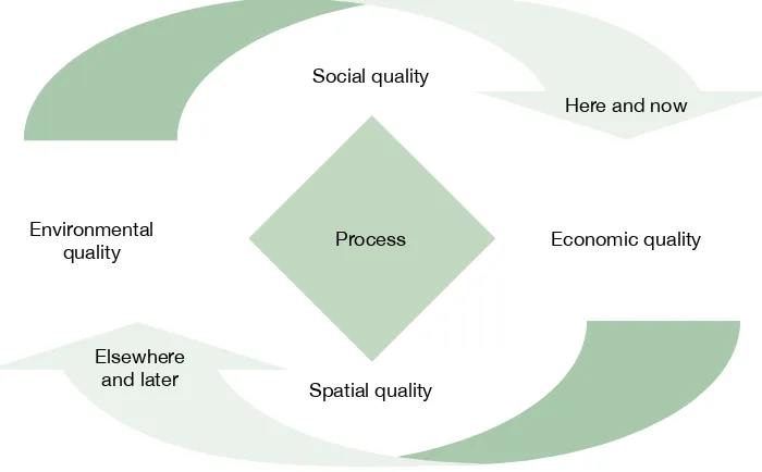
The key element in sustainable development, therefore, is the understanding that quality is a broad concept, combining different perspectives: environmental quality, spatial quality, social quality and economic quality. Developing and implementing this vision happens in a participative process, with all stakeholders involved. Not only is the present and local situation taken into account, but also the expected impact that choices in the urban fringe have on other areas, nearby or far away, and the expected impact in the future. This is, in short, a summary description of a sustainable urban fringe. Figure 1 represents the SURF perspective on sustainable development:
Figure 1: Sustainable development (De Bruijn 2004)
The challenge in the design of products and buildings and in the planning of areas is to add quality, to create added value, preferably in different dimensions. For example, a well-designed housing or business site in the urban fringe can produce energy instead of using less energy than the norm, e.g. by having enough photovoltaics or use of geothermy. It can improve water quality instead of polluting less than allowed, e.g. by having a green roof or water purification in constructed wetlands. It can add biodiversity instead of destroying biodiversity less than formally allowed, when intensive grassland or corn cropland is replaced by a well-landscaped green business site or public green space.
Development should not only add environmental quality, but also quality with respect to the other dimensions of sustainability, and to create synergy where possible. The search for synergy usually leads to more creative and unexpected solutions, compared with the search for balance, as a result of a different mind-set.
Social quality
Here and now
Economic quality Environmental
quality Process
Spatial quality Elsewhere
Apart from synergy between the dimensions of sustainability, planners and developers should also look for synergy between different areas and different stakeholders: synergy between the city, the urban fringe and the rural area, and synergy between the authorities, citizens and private investors.
Opportunities for mutual benefit increase substantially as a result of technological innovation: technology for sustainable energy becomes cheaper and more convenient to use, facilities for water storage and purification can also add to spatial quality and biodiversity opportunities in an area, etc.
The search for synergy might also lead to situations where interests are still conflicting or where stakeholders have the perception of conflicting interests. Of course it is important to keep an eye open for these situations when they appear and to look for technical or financial means to remove existing conflicts of interest, or to improve communication to counteract existing misperceptions about conflicting interests.
A few examples may clarify this approach to sustainability. Water retention to cope with more extreme weather conditions is becoming a prime function in many urban fringes. This creates good opportunities for nature development and recreational functions. Another example is the development of new estates which often combine a housing function, some economic functions (recreation, agriculture or otherwise) and the restoration of landscapes. A further example is the redevelopment of former farms into broader business concepts in which regional food production is combined with farmers markets, or social-care farms where farming activities are offered as day programmes for small children, or for those with learning difficulties or mental health sufferers.
Tools for sustainable urban fringes
Departing from the perspective that urban fringes present a complex challenge for local and regional governments, both substantive and with regard to the visioning and planning process, the tools presented in this toolbox are attempts to deal with this complexity. In particular, the tools help governments to build relationships with other parties, governmental, private and non-governmental. They also help in coping with the complexity of an integral perspective on quality.
This section describes the tools used within SURF that helped or can help in realising sustainable development in urban fringe areas. The list of tools is not by any means intended to be exhaustive, nor does it intend to address all possible situations. Rather, the function of this toolbox is to inspire by showcasing promising tools that are already being used and have shown to produce intended results.
The tools are divided into two different categories, with a clear link to the vision on sustainable development previously explained:
• building networks between stakeholders in the urban fringe area;
• creating synergy between different qualities in the area.
Each of the tools is described in some detail to allow an understanding of the specifics of the tool. In this description the use of the tool in the urban fringe receives special attention. To this end, a short characterisation of the area and context is included, next to the goals that the governmental agency sets and the results it produced. For all tools, an indication of the success factors is included as well as elements that could be strengthened. Contact details are included in order to gain more in-depth information.
The tool description is based upon information provided by the SURF project partners, in face-to-face interviews, email communication and telephone calls. All the descriptions of the tools were checked and confirmed by the project partners. The reflection on the results obtained and the strengths and weaknesses of the tools (‘why did it work?’, ‘what could be improved?’) is also mainly based upon the perception of the SURF project partners.
This approach implies that the description of the SURF tools should not be considered as firm scientific evidence for the quality of the tool or the opportunities to apply the tool elsewhere. It should be considered as a source of inspiration for new approaches to involve stakeholders and realise synergy between qualities in urban fringe areas, based upon three years of practical experience of the project partners involved.
Below is an explanation of the tool categories with a summary of the tools presented and a more detailed factsheet-type description of all the tools. Each tool has one or more of the characteristics briefly described here:
• Communication: all forms of communication, both interpersonal and through mass media of all kinds: awareness- raising, education, stakeholder participation;
• Regulation and legal conditions: where specific formal and legal procedures are developed or applied, like zoning plans, building permits etc;
• Planning and design: all tools where physical planning and urban design play an important role: the distribution of functions and activities in an area, and the design of areas, structures and buildings;
• Financial tools: all tools where financial incentives are used to stimulate the desired behaviour of stakeholders: subsidies, taxes, investment opportunities etc;
Tool category: Building Networks
Introduction
Sustainable development in urban fringe areas can only be realised if all stakeholders are involved. Public authorities traditionally had the leading role in land use planning but in many situations this is changing rapidly. Real estate developers, landowners and other private investors have a substantial influence on developments, and the existing practice of top-down decision-making by public authorities is gradually shifting towards a more bottom-up oriented approach to governance. This makes it necessary to develop tools for building networks and organising stakeholder engagement, in different stages of the decision-making and planning process and on different levels of scale. In urban fringe areas, this task can be extra challenging because of differences in culture and tradition between ‘urban’ and ‘rural’ networks and stakeholders, and because of the complexity of the responsibilities of the different levels of authorities in the urban fringe.
The tools in this section focus on this process of network building and stakeholder engagement. The Province of Antwerp uses stakeholder participation to determine landscape quality objectives in their project area, the Laarse Beek (Laarse watercourse). The Open Space Audit in Aberdeen, Scotland, involves civil servants from many different sectors and inhabitants and other stakeholders in the process of area assessment, leading to awareness and involvement of many stakeholders and to a common knowledge base for future activities in the area. The Virtual Flythrough,
developed in Norfolk, England, is a digital tool that provides new opportunities for engaging with different audiences by making geographical data more easily accessible. The communication strategy of Norfolk shows how the authorities combine the use of traditional communication methods and new methods (online, social media), for an integrated communication strategy for awareness raising and network building. The Neighbourhood Forum in the Hamburg region is an informal platform where different area authorities work together and exchange information on planning issues in the urban fringe. The region of Twente developed a regional vision for the urban fringes of five neighbouring
municipalities, and elaborated a project agenda based on this vision. Within the Green Knowledge Portal, local and regional authorities work together with educational institutes on different levels, from schools for vocational training to universities of applied science. This is also applied in West Flanders. The Weusthag Foundation is a citizen initiative to set up a foundation with stakeholders who feel connected to the Weusthag Park area and who work together. The municipality of Hengelo has a strategic alliance with this foundation.
• Stakeholder participation to determine landscape quality objectives (Province of Antwerp, Belgium)
• Open space audit (Aberdeen, Scotland)
• Virtual Flythrough, Google Earth (Norfolk, England)
• Integrating communication methods (Norfolk, England)
• Neighbourhood forum (Free and Hanseatic City of Hamburg, Germany)
• Regional vision development (Region of Twente, the Netherlands)
• Green knowledge portal (Region of Twente, the Netherlands)
• Cooperation between authorities and higher education (Province of West Flanders, Belgium)
Stakeholder participation in determining landscape quality objectives
(Province of Antwerp, Belgium)
The tool
The Province of Antwerp has focused on the improvement of the quality of the urban fringe in the north-east of the city of Antwerp, especially around the small watercourse the Laarse Beek. In order to create more awareness of the plans and gain a better impression of the views of inhabitants and visitors, the Province of Antwerp created different tools for stakeholder engagement in the assessment of the present qualities of the area and in identifying opportunities for improvement of the area.
Relevant tool characteristics
• Communication
• Stakeholder engagement
The context
Area and context:
The urban fringe in the north-east of the city of Antwerp is considered as an area where green space is important on a local and regional level. Although the area is relatively forest-rich, the urbanisation degree is 35%. The urban fringe contains a complex network of watercourses, with the Laarse Beek stream flowing centrally. The area is characterised by a high degree of private ownership and transport networks to and from Antwerp and its port. This creates several problems:
• limited amount of area suffering from a very high recreational pressure;
• large distances between locally concentrated living areas and accessible green spaces;
• open space close to concentrated living areas strongly influenced by the inhabitants of these areas: gardens, space for horses etc;
• pressure on the biodiversity of the urban fringe; • negative perception of parts of the area.
The complex government structure and the multifunctional character of the urban fringe area further increase the complexity. The steering committee of the Water Board Het Schijn, the wider area to which the watercourse Laarse Beek belongs, has officially expressed the intention to develop an integrated project in the valley system of the Laarse Beek. This Water Board consists of delegates of the Province of Antwerp, local authorities and water managers.
Project Objective:
The project as a whole aims to improve the quality and accessibility of the urban fringe in the north-east of the City of Antwerp in a process of close cooperation with all authorities, stakeholders and inhabitants concerned, to create sustainable, long-term results.
Activities:
Questionnaire
The main activity was a questionnaire, available online and as hard copy in public places in the Laarse Beek area. It was also distributed during a big event in the area. The questions asked respondents for their perception of the area, the way they use it, and their suggestions for improvement. An A0-size poster accompanied the hardcopy questionnaires and informed possible respondents about the Laarse Beek project and about the questionnaire. Other supporting communication was also used to reach possible respondents. A selection of the respondents received a complimentary gift after they left their email address.
SWOT analysis
The interactive SWOT analysis was aimed at the different stakeholders in the area. The information for the analysis was gathered during an evening event where different stakeholders were invited. These groups included, amongst others, environmental, socio-cultural, agricultural, employer and employee associations, and schools. By creating a mix of different interests from the different municipalities a broad variety of ideas emerged. The evening was moderated by an external discussion leader to create a neutral atmosphere. Three themes were discussed: tourism and recreation, accessibility, and nature and water.
Online communication tool
Because of the large number of local inhabitants, a web-based animated interactive tool was created that allows people to ‘read’ the landscape and give an opinion on future objectives and services. The online communication tool combines a desktop and mobile website, with 360° views, lots of information and different ways to question visitors about their preferences for the landscape. Visitors to the area who are looking for information will thus be more easily reached and the dynamic environment of a website will also attract a broader audience to give their opinion on the urban fringe. Being dynamic, the tool allows other questions to be asked of visitors to the site when the quality of the open space in the urban fringe changes.
Public event
To bring people back into connection with the Laarse Beek and the green spaces in its vicinity, a public event was organised together with local stakeholders. The purpose was twofold:
1) informing visitors and inhabitants about the urban fringe and the on-going and planned processes in the area, and
2) questioning people regarding how they experience the urban fringe, and gathering suggestions they might have.
The reason for this twofold approach is that a participative process is more likely to give a better return when the participants are informed.
Results:
In the first half of 2012, about 50 people filled in the questionnaire and 25 participated in the SWOT analysis. The most important things the project partners learned were, amongst others, that the area lacks its own identity, that there is a need to improve accessibility along the watercourse and between existing green spaces, that nature is valued highly, and that more information should be given to the inhabitants regarding topics such as regulations along watercourses. These findings led to a higher awareness among policy-makers regarding the perception of the urban fringe and its potential as seen by the inhabitants and users of the area. Their ideas can be used as an inspiration for the future development of the area. By informing people and giving them a voice through the questionnaire, SWOT and the online tool, networks were built with stakeholders and awareness and involvement of people in the neighbourhood were created.
Reflection
Why did it work?
The most important success factor was that the urban fringe was brought to the attention of users and visitors to the area, which has enhanced awareness and local involvement. A combination of different media was used to obtain this, both modern and online, and classic media like posters, exhibitions and events. This helped to attract and reach different groups of stakeholders. Because of this ‘stakeholder democracy’, people feel more connected to the area and the processes that are taking place.
What could be improved?
More people could be encouraged to fill in the questionnaire at public places with a project representative present, actively informing potential respondents about the project and stimulating them to fill in the questionnaire. However, this implies a higher amount of staff costs. One should also be aware that when an area clearly lacks its own identity, people might not yet feel sufficiently engaged to give their opinion. Furthermore, if it is clear to the respondents what will happen with the results, they might feel more engaged.
Open Space Audit
(Aberdeen, Scotland)
The tool
The Open Space Audit is a participative, integrated inventory of the quantity, quality and distribution of different types of open spaces within the City of Aberdeen. The methodology assesses the quality of the open space from different perspectives and with the involvement of different categories of stakeholders: experts, users, decision-makers, and city staff. This approach allows experts to acquire a broad understanding of the quality and appreciation of open space, creates awareness among citizens, and allows them to participate in the process of green space improvement.
Relevant tool characteristics
The Open Space Audit is required by Scottish planning policy. Cities are required to provide an overview of the quantity, quality, accessibility and community value of publicly accessible open spaces.
The audit and assessment for Aberdeen was used to inform and support policies in the Local Development Plan and also to inform the preparation of the Open Space Strategy, which seeks to achieve a network of attractive, appealing, well-connected community places. The Open Space Strategy provides a framework for the management and development of Aberdeen’s open space which enables the whole community – residents, businesses, community organisations, voluntary and statutory agencies – to work in partnership towards achieving the maximum benefit from our open spaces.
Area and context
Aberdeen, also known as the Granite City and the Oil Capital of Europe, is a compact (189 sq km) city located on the north east coast of Scotland. It is known for its granite built heritage and quality open spaces, having won many accolades for these over the decades. It is also known for its unusually buoyant economy and low unemployment, mainly underpinned by the energy and life science sectors. It benefits from quality higher education facilities, knowledge institutes and a highly skilled workforce. All these factors provide for a consistently high quality of life and make Aberdeen is a fast growing cosmopolitan city. It is estimated the population of Aberdeen will increase by 25% over the next 20 years, approximately. This in turn means the pressure for new housing is high,
with land allocated for 36,000 new homes over the same period.
The River Don catchment is also of huge importance to the city with a rich cultural and built heritage, including Old Aberdeen and former key industrial sites. It also supports an abundance of important wildlife and is home to vibrant communities. However, it does cut through areas of social deprivation and industry, once
being the power source and outflow for the city’s mill industries. It is also far less well known, respected and suffers from inconsistent and poor access in places.
Aberdeen’s Open Space Audit has provided the information for policy makers and citizens to understand the quality of the city’s publicly accessible open spaces at a time of major growth. Through the SURF Project, this information has been brought together with stakeholder groups to allow a collaborative approach to improving an area of the city’s urban fringe, the River Don Corridor.
Project Objective:
The project aims to:
• develop a clear and robust understanding of open space in Aberdeen;
- see whether Aberdeen’s communities have enough open space, or enough of the right types of open space;
- gather information on the quality of Aberdeen’s open space;
• support a strategic approach to improving Aberdeen’s open spaces;
- supporting development and delivery of an Open Space Strategy for Aberdeen;
- supporting the Local Development Plan to deliver more sustainable development by providing information and standards to guide developers.
Activities:
This Open Space Audit has been carried out according to national best practice guidance from greenspace scotland, the national body representing Scotland’s urban open spaces, and the Scottish Government. It combines the information collected by earlier relevant projects along with site assessments and community engagement carried out in 2009 and 2010. The quantity, quality and accessibility of Aberdeen’s open spaces have been established through the following assessments:
• Greenspace Characterisation & Mapping Study 2007 – funding was provided by greenspace scotland to develop a comprehensive digital map of all of Aberdeen’s green space. The project involved analysing aerial photographs and identifying the land use category, or type of all of the urban land in Aberdeen, plus a 500-metre buffer around the built-up areas.
• Greenspace Audit 2007 – as a recommendation of Aberdeen’s Parks and Open Space Strategy 2005 an audit of the city’s parks and green spaces was undertaken. The 2007 audit provided an assessment of publicly
managed green space at least 0.4 hectares in size.
Site assessments were mainly done by staff from Aberdeen City Council. In total, 10 staff members were involved. In order to find the necessary resources as well as encourage a broader awareness of city staff in this process, the staff came from the Local Development Plan and Environmental Policy teams. This implied that the site assessments were not only done by experts in the field of ecology and green space but by a broader group of people representing both users and planners/decision–makers.
Community engagement was undertaken as part of this project from December 2009 to January 2010. This was mainly done through a questionnaire available in hard copy and online.
Results:
Project results
The Open Space Audit provided an overview of the categories, quantities and qualities of all publicly accessible open space in the city over 0.2 hectares (excluding farmland and private gardens). The level of detail means the information can be manipulated and assessed at various levels, from citywide to more localised political ward boundaries.
The most important conclusions regarding the quality of the open space were as follows:
• open spaces across the city are not evenly distributed;
• the poorest quality parks and open spaces tend to be within the more deprived communities; • there are very many small, often poor quality play spaces;
• some areas of the city have very little open space, and what they do have is poor quality;
• more recent residential developments in suburban areas have the highest quantities of open space but much of this takes the form of low-quality, expensive-to-maintain amenity grounds.
Process results (results regarding community involvement and awareness)
In December 2009 a questionnaire was launched, which aimed to capture the public’s views on open space provision, quality and accessibility. Copies of the questionnaire were distributed to all of the city’s public libraries and customer access points, and posters advertising it were put up at public events and in park notice-boards. An online version was promoted on the council’s website. The survey ran for seven weeks and a total of 125 responses were received. 110 of the completed questionnaires were submitted online and 15 hard copies were completed. Although this is a very small number in relation to the population of the city, the response rate is reasonable in comparison to other local public consultations. The fairly small sample size does present a limitation to interpreting the results, however the questionnaire responses did provide useful results and have helped to give some indication of public opinion. The review of relevant documents also provided useful information on local people’s views, as did public information collected by GreenStat – an online, UK-wide database which the public can use to comment on their local open spaces.
Reflection
Why did it work?
What could be improved?
The Audit could be improved by spending more time earlier in the process planning the use of Geographical Information Systems; the identification of sites for audit, and the methods for capturing and storing the information. Options to create more community involvement in this process: the community involvement was relatively limited at the time of the audit due to constraints on time and resources. The Audit is a snapshot in time and by utilising more participative and ongoing communication methods, such as social media in future, the City of Aberdeen hopes to achieve more community input and buy-in, providing a stronger evidence base and greater success in delivery.
Contact information:
Aftab Majeed
Planner (Environment)
Sinclair Laing
Senior Sustainable Development Officer
Planning & Sustainable Development Aberdeen City Council
email: [email protected]
Virtual Flythrough, Google Earth
(Norfolk, England)
The tool
The Virtual Flythrough Tool is a unique platform for managing complex and varied electronic datasets for the special environment of the Gaywood Valley catchment (see pictures below). It also provides new opportunities for engaging with different audiences by making the data more visual and enabling people to explore the Gaywood Valley from the comfort of their home. It has also had a surprising benefit in terms of engaging with schools and has been tested with a good deal of success by two local primary school classes which want to develop their IT skills.
Relevant tool characteristics
• Planning and design • Communication • Digital and online tools
The context
The King’s Lynn and West Norfolk area has a diverse flora and fauna as well as a complex and fascinating history. In the past consultation with local people has been difficult to achieve for varying reasons, partly apathy with the local council, the size of the borough being an obstacle (552 sq miles; 1,429 km2). Also many of the outlying villages (over 100 parishes) are quite isolated and therefore difficult to engage with. The population is quite old as many retire to the Norfolk coast and therefore engaging with younger residents is important as their needs can be overlooked when providing for the long-term stability of the borough.
Area and context:
King’s Lynn is the northernmost settlement on the River Great Ouse. The population of the town is 42,800. The town lies about 5 miles (8 km) south of The Wash, an estuary on the north-west margin of East Anglia. The Great Ouse at Lynn is the outfall for much of the drainage system of the Fens. The much smaller Gaywood River also flows through the town, joining the Great Ouse at the southern end of South Quay close to the town centre.
The Gaywood is a short chalk river some 13km in length that rises from springs near Derby Fen to the east of King’s Lynn. The river discharges into the Great Ouse at King’s Lynn through a tidal flap and then into the North Sea through The Wash estuary. The SURF project area follows the catchment of the River Gaywood and spans approximately 5,700 ha.
The Gaywood River Valley Project will provide local communities with opportunities for education, recreation, enjoyment and understanding of the urban fringe around the town of King’s Lynn.
Project Objective:
To meet the huge challenges posed by climate change and the rapid pace of development in and around King’s Lynn, the importance and true value of natural assets needed to be reassessed. The project tried to combine diverse areas of interest, like improvement of biodiversity, geodiversity and cultural history, flood alleviation, improvement of physical health, learning and education and community engagement.
Specific aims:
• protection of habitats and species from the impacts of climate change and a growing population;
• improved access to the countryside and better understanding and valuing of its importance by local people; • bringing local communities and partner organisations together to work on a shared vision for the future of the Gaywood Valley.
Activities:
The Flythrough Tool was publicised and the website link launched in the two local papers and the Gaywood Valley Project newsletter. The University of East Anglia, who developed the tool, also installed a portable ‘pod’ where the virtual flythrough tool could be displayed to good effect at the public launch event for the project in May 2011. The flythrough was also shown to project stakeholders on two occasions at the technology suite at the University of East Anglia to get ideas and feedback as the tool was developing. Around 15 project stakeholders attended the sessions.
The virtual flythrough was shown to elected members at a Gaywood Valley conference in September 2011 and was very positively received, with some of the elected members asking whether the tool could be applied in the planning department of the council. Around 15 elected members attended the masterclass.
Results:
Use of the tool requires a fairly good knowledge of working on an internet platform – clicking layers on and off for example, pausing the tour by clicking on the relevant text, using hyperlinks and zooming out. This has been undertaken with far more confidence and ease by schoolchildren than by an adult audience, no doubt because most schools are using the internet and computers as part of the daily class activities. The children easily moved around the tour and even used other parts of the site to see what would happen, taking an experimental approach to using the tool. They thought the session was ‘fun’ and ‘interesting’. They understood the concept of GPS and the need to value the Gaywood Valley environment. Little supervision was in fact needed to demonstrate the tool as the children picked it up straight away.
Experiences with adult audiences have been mixed. For those who are confident using the internet and Google Earth the tool has been a success and has been used as a way of finding more out about the area and the project. Some people, however, have struggled with the software as their own software is out of date and therefore the tool loses functionality. Some people have also not read the on-screen instructions properly and therefore have not been able to turn the right layers on and off, and some have had difficulty installing the free Google Earth software to run the tool.
Success factors
Why did it work?
The strength of the tool has been its level of data but also its simplicity. Access, biodiversity, geology, hydrology, heritage, climate change, topography, population data and green infrastructure can appeal to quite a broad audience for a range of different needs – planning a walk for example, or undertaking a school geography project.
The simplicity has made the tool more accessible and meaningful.
The idea to trial it on local primary school children was a good one and the two schools have a very good working relationship with the University of East Anglia as a result.
Another strength is that it is a different way of obtaining information in the comfort of your own home and also of consulting the public. The tried and tested PowerPoint presentations in village halls are not inspiring people. This new concept therefore is moving away from this method and encouraging people to be a bit more proactive about finding things out about their local environment and attracting younger audiences who are traditionally very hard to engage with.
What could be improved?
The tool could have benefited from more publicity and maybe more workshops with local communities. This was constrained by resources, as the university staff are extremely busy.
There were also some technical difficulties in that the county council’s Information Technology Department would not allow officers to install Google Earth on their work computers, even though the software is free. This means that many of the officers can’t access the tool in work time, at least not without permission from the IT department. This caused setbacks in terms of the tool’s development and in the end the relevant officers had to use home computers to access the tool and provide feedback to the university.
tool and would be a centralised place for people to add information, photos and stories, and to find out more about the Gaywood Valley and other project tools. It is hoped that a simple website with a few pages can be set up quickly by the end of the project to park information and reports including the flythrough link.
Contact information
Professor Andrew Lovett ZICER 0.03
School of Environmental Sciences University of East Anglia
Norwich Research Park Norwich
NR4 7TJ United Kingdom
tel: 01603 593126 (+44 1603 593126)
email: [email protected]
web: www.uea.ac.uk/env/research/reshigh/gaywood
Gemma Clark
Gaywood Valley Project Officer Norfolk County Council West Area Office Poplar Avenue Saddlebow King’s Lynn Norfolk PE34 3AQ
tel: 01553 778024 (+44 1553 778024)
Integrating traditional and modern communication methods
(Norfolk, England)
The tool
Short description of the tool
For the urban fringe projects of Norfolk to be successful stakeholders need to understand why there was a need to have access to high-quality green space, the importance of the Gaywood Valley in terms of its high-quality environment, the importance of the benefits derived from the valley, and how this area can help the project area adapt to the changing climate by providing flood storage. To communicate these messages effectively a number of methods were used during the life of the Gaywood Valley Project. These included a project logo, the use of social media site Twitter, the production of four quarterly newsletters, the production of two project pop-up displays, masterclasses, community events, a virtual flythrough tour of the valley, a database of contacts, a Joint Advisory Group and an Advisory Group, a community wildlife toolkit, and engagement with schools.
Relevant tool characteristics
• Communication
• Digital and on line tools
The context
The King’s Lynn and West Norfolk area is large and in places very isolated. The Gaywood Valley as an area was unknown even to local people and many didn’t know the route of the Gaywood River. It was crucial that the message of SURF and the identity of the Gaywood Valley were recognised early on to enable active community participation.
Area and context:
The King’s Lynn and West Norfolk area has a diverse flora and fauna as well as a complex and fascinating history. In the past, consultation with local people has been difficult to achieve for varying reasons – partly apathy with the local council, the size of the borough being an obstacle at 552 sq miles (1,429 km2). Also many of the outlying villages (over 100 parishes) are quite isolated and therefore difficult to engage with. The population is quite old as many retire to the Norfolk coast and therefore engaging with younger residents is important as their needs can be overlooked when providing for the long-term stability of the borough.
The Gaywood is a short chalk river some 13km in length, rising from springs near Derby Fen to the east of King’s Lynn. The river discharges into the Great Ouse at King’s Lynn through a tidal flap and then into the North Sea through The Wash estuary. The SURF project area follows the catchment of the River Gaywood and spans approximately 5,700 ha. The Gaywood River Valley Project will provide local communities with opportunities for education, recreation, enjoyment and understanding of the urban fringe around the town of King’s Lynn.
Project Objective:
Specific aims:
• protection of habitats and species from the impacts of climate change and a growing population;
• improved access to the countryside and better understanding and valuing of its importance by local people; • bringing local communities and partner organisations together to work on a shared vision for the future of the
Gaywood Valley.
Activities:
An Engagement Plan for the project was firstly drawn up. This looked at the type of communication that should be explored and the types of audiences involved. The plan then broke the engagement down to the specific needs of each audience and when the engagement activities would take place. The first activity was to organise a schools competition to design a logo for the project. The guidelines were sent out
to primary and secondary schools in the project area and we received a staggering 188 replies. This large number probably can be explained by the fact the schools were already engaged in classroom activities regarding the design of logos. The finalists were selected by the project Advisory Group and the winner decided by the Joint Advisory Panel. The logo has been an important tool for the project by providing a recognisable brand and also by forging close links with the local schools that contributed.
A selection of community events in conjunction with the Norfolk Wildlife Trust ran in the first year, including walks, talks and family events based around local wildlife in the Gaywood Valley area. This enabled people to get out into the Gaywood Valley if they had not before to learn more about their local environment and biodiversity.
Other heritage events have been held with the North End Trust, St Nicholas Chapel and West Norfolk Archaeological Society. The Project Officer has also given PowerPoint presentations at a number of events and venues. This has enabled communities and officers outside the project area to become involved. Twitter is used to advertise up-and-coming events and also to relay messages to partners and stakeholders, and is an effective tool to engage with younger audiences. This has resulted in 380 followers, mainly through recommendations of followers themselves.
The Project Officer produces a quarterly newsletter and distributes in hard copy and email format to parish councils, schools, landowners, local elected members, special interest groups, officers and members of the public who have chosen to be on the Gaywood Valley publication circulation list.
Two pop-up displays were set up and displayed in the front of the borough council offices and in a local café/tourist attraction called the Green Quay. This has enabled the project to be seen by a large number of tourists and local people visiting the buildings.
Two masterclasses were held, one for officers and one for elected members. This was to look primarily at the subject of ecosystem services and its delivery in the project. For the elected members event a series of formal presentations was held in a local museum with a buffet lunch and tour of the museum after. For the officers’ masterclass there was a mixture of presentations and a workshop session.
Engagement with schools has involved local meetings with teachers to talk about ways in which the project can help them to deliver sessions outside in the valley, the development of an education pond area in one of the schools, two sessions with the University of East Anglia looking at GPS and geology, and a programme of teaching sessions with a local secondary school. Resource packs have also been developed for teachers by the University of East Anglia.
The project relies on its Advisory Group and Joint Advisory Group to feed in their ideas and help to disseminate information. These are a range of stakeholders with an interest in the project and area.
Results:
It is clear that no one specific type of engagement fits all the requirements. Effective communication and network building involves a variety of engagement methods to different audiences over a period of time. In fact it is only really now that the engagement work is starting to pay off and more people are finding out about the project.
Success factors
Why did it work?
The project has taken an experimental approach to engagement and network-building, trying a variety of approaches. The use of Twitter and the Virtual Flythrough tool has enabled the project to access younger and less IT-literate audiences. For some the newsletter, although very basic, was seen as a very effective, simple method of communication. The wildlife events were slow to start off with as people were not used to the type of events on offer but these are now attracting on average 40 people per event. As word spread the numbers slowly increased. The project team also worked very closely with the West Norfolk Archaeological Society and a local museum which has engaged more people through their interests. The project team has worked hard to ensure that the needs of the audiences are being heard, more heritage-related events have run as this was seen as something the community wanted to learn more about in the valley area.
What could be improved?
The business sector has not been represented in the network-building of the project and it has been difficult to find a way into this sector. Schools also have been particularly difficult to engage with although the project tried to be persistent with this group. Most teachers simply don’t have the time to meet outside of school hours and it has been a struggle to fit the requirement of educational engagement into the secondary schools’ curriculum.
Engaging with the public has been a slow, drip-drip process but the work is finally starting to be recognised and more contact is being made. The general public are slightly cautious about getting involved with things they are not familiar with so this was always going to take time.
The local newspaper could have done much more to promote the project. Numerous press articles were sent out but as this is essentially a positive project and the paper in question is more concerned with highlighting the negatives of the area, it has been a bit of a stumbling block to getting the message out there.
Contact information:
Gemma Clark
Gaywood Valley Project Officer
Norfolk County Council, West Area Office, Poplar Avenue, Saddlebow King’s Lynn, Norfolk, PE34 3AQ
tel: 01553 778024 (+44 1553 778024)
email: [email protected]
Inter-municipal Neighbourhood Forum
(Free and Hanseatic City of Hamburg, Germany)
The Tool
The inter-municipal neighbourhood forum is a governance tool to engage several levels of regional and local public administration of Hamburg and its neighbouring municipalities in a regular exchange on development issues. The forum aims at exchanging information on development plans before formal planning processes are started. Building of trust and confidence is another major aim of the tool. The forum is informal, non-political and members take part voluntarily.
The very first inter-municipal neighbourhood forum was initiated in 2012 with a launching session in April 2012. It aims to meet twice a year. It involves municipalities of the federal state of Schleswig Holstein and the regional district South of Hamburg as well as the respective District of Hamburg and the Urban Development Ministry of Hamburg.
Relevant tool characteristics
• Planning and design • Communication
The context
Region and country:
The Free and Hanseatic City of Hamburg (Freie und Hansestadt Hamburg), represented by the Department for Urban and Regional Planning within the Ministry of Urban Development and Environment (Behörde für Stadtentwicklung und Umwelt, Amt für Landes- und Landschaftsplanung, Referat Raumordnung und Regionalentwicklung) and Hamburgian City-districts (Bezirke); neighbouring municipalities and districts formally belonging to another federal state like Schleswig Holstein.
Area and context:
The format of a neighbourhood forum has to be seen in the context of the structure and the strict formal culture of the civil service in Germany, and in the context of the specific situation of the Free and Hanseatic City of Hamburg. Hamburg is at the same time federal state and local municipality. In hierarchical terms it equals the status of the bordering state Schleswig Holstein to the north and Lower Saxony (Niedersachsen), south of Hamburg, as much as it equals a small local municipality across its borders. This specific characteristic causes difficulties because eye levels and perspectives differ.
On the municipal planning level, the municipalities in Schleswig-Holstein and Lower Saxony have to address their issues to the federal state level in Hamburg. They are not in direct contact with the city-district authorities of Hamburg, although those deal with local planning issues. Different eye levels and perspectives often cause lengthy communication lines and misunderstandings and have sometimes even lead to unnecessary conflicts and lost opportunities of synergies.
The concept of the neighbourhood forum was first introduced in Berlin and its neighbouring federal state Brandenburg after the fall of the Wall that divided former West Germany from former East Germany. After the reunification of Germany, Berlin suddenly had neighbouring municipalities with whom Berlin had severe and pressing planning issues to deliberate and discuss. And the planning officials had never met!
So here the neighbourhood forum served as an informal institution, enabling the planning experts and officials to get to know each other and to build trust. This had a great impact on the coordination and programming in the region. In the case of Hamburg (like Berlin and Bremen, a Free City State) this format of the neighbourhood forum was introduced to work towards the same objectives of building trust and to deliberate on planning issues of mutual concern in an early stage.
Project Objective:
The inter-municipal neighbourhood forum aims at conceptualising an informal process, which helps to increase planning efficiency and the coordination of spatial development in the urban fringe.
Activities:
Arrangement of a neighbourhood forum meeting twice a year to deliberate pending planning issues.
Results:
The results until now can mainly be considered as process results; the approach led to improved information exchange and coordination of spatial development in the urban fringe. Planners from the different authorities know are aware of the plans and ideas of neighbouring authorities at an earlier stage. This creates better opportunities for cooperation and coordination. In the longer term, this will hopefully lead to physical results, bringing more coherence in the spatial quality of the urban fringe zone around the city of Hamburg. At this moment, it is too early to state if this will really be realised.
Reflection
Why did it work?
Based upon the experiences until now, the following success factors were mentioned, formulated as suggestions to project managers and participants in such a type of project:
• the most important success factor is to ensure the municipality is involved with all relevant sectors like the municipal planning department etc;
• the trap to avoid is to involve too many stakeholders or to tackle too many issues at once; • start with consensus-prone issues and bring in the difficult ones when trust has been built; • acquire a political ‘go’ on the main lines, avoiding political involvement in the details;
• observe the right balance in status of the officials to be involved in the neighbourhood forum between the central city and the municipalities in the fringe;
Contact information:
Freie und Hansestadt Hamburg
Behörde für Stadtentwicklung und Umwelt Amt für Landes- und Landschaftsplanung
Raumordnung, Regionalplanung und EU-Angelegenheiten Petra Pelster
Guido Sempell
Alter Steinweg 4 / 20459 Hamburg
tel: +49 40 42840 8053
fax: + 49 40 42840 8396
Regional vision development
(Region of Twente, the Netherlands)
The tool
Government agencies, at different governmental levels, have jointly developed an integrated vision and implementation plan for peri-urban zone in the Twente Region. The following governments were involved:
• municipalities: Almelo, Borne, Enschede, Hengelo, Oldenzaal; • regional authorities: Province of Overijssel, Region Twente; • Waterboard Regge & Dinkel (2 rivers);
• ministries: Ministry of Housing (now Infrastructure & Environment) and Ministry of Agriculture & Nature (now Economy, Agriculture and Innovation).
Joining forces had two main motivations. Internally, the governments saw the need to coordinate their actions. Moreover, the idea was that jointly they could apply more easily for external funding. The regional vision consists of the vision itself and an implementation plan.
Relevant tool characteristics
• Regulation and legal conditions • Communicative instruments • Planning and design
The context
The urban fringes of the Network City Twente form special and dynamic transition zones with both urban and rural characteristics. They are at the centre of political and administrative interest because they offer opportunities for housing, recreation and tourism, new forms of economy on the edge of the city to replace agriculture, and as a recreational area for the city. During the last few years the municipalities in the Network City Twente – Almelo, Borne, Hengelo, Enschede and Oldenzaal – have made all kinds of plans for the urban fringes. Jointly with the Ministry of Infrastructure and the Environment, the Province of Overijssel, the Twente Region and the Regge and Dinkel Water Board, these five cooperating municipalities have merged the different subsidiary visions into an integral and collective vision for the urban fringes of the whole Network City.
All governments involved had plans and initiatives for their urban fringes ranging from concrete measures to abstract plans. There was little coherence at regional level, although there was a clear interdependence as the different cities are quite close to each other. There was also a strong feeling that citizens did not understand different governments competing towards the same goal. Their interest is in having strong and effective governance arrangements and to create more coherence in the complete urban fringe area of the region, with respect to issues like infrastructure planning and the realisation of recreational facilities. Therefore it was decided to develop:
• an integrated vision on urban fringes in the urban zone of the Region Twente (“Network City Twente”), building upon all existing individual plans and visions;
• a common implementation programme;
Area and context:
The Region of Twente has two faces. On the one hand it is one of the most densely populated areas of the Netherlands, with a well-developed knowledge infrastructure consisting, among other things, of two universities and many high-tech spin-offs. At the same time it has a rural atmosphere in between the major cities and in the smaller towns. The alternation of urban qualities with high-quality landscapes is one of the main assets of the region. Urban-rural relationships, therefore, play a main role in the region. Twente has a long history and is a ‘real’ region and not only a governmental construct. Networks are many and tight.
What was originally a row of separate cities in Twente – Almelo, Borne, Hengelo, Enschede, and a little further away Oldenzaal – has grown within the space of a century to become a large urban agglomeration in which the cities have virtually merged with one another. They developed along major lines of infrastructure. There is a high likelihood that, unless drastic spatial policy is forthcoming, these cities will grow even closer together in the future. Based upon the present and expected demographic development in the region, this growth is expected to come to an end in the next few decades. Urban Fringes created today could potentially become future regional boundaries.
The spatial vision of the fringes of the Network City has three components:
• relatively non-dynamic zones on the urban fringes that are interwoven with the landscape; • dynamic and enclosed zones with an identity of their own;
• a cohesive slow traffic network.
Also included in the vision is a toolkit consisting of six instruments, or policy principles:
• green lobes to be secured against the urban pressure;
• green wedges that provide green routes from the city to the surrounding countryside; • improvement of the city-countryside transition;
• city-nature interweaving zones where the ambition is to create soft transitions from the city to the countryside, with recreational possibilities close to the city that are linked to water and nature;
• recreational network: circular routes; • recreational network: radial routes.
Project Objective:
The goals were twofold:
• tuning and coordinating the plans and activities of the individual governments; • finding external funding for joined challenges.
The idea is that by joining forces the partnering governments can make a stronger voice towards potential funders (often provincial and national governments). Instead of competing with each other the aim is to have more coordination and therefore more/better results.
Activities:
The development of the Regional Vision took a rather elaborate policy development process which was nevertheless completed within a year.
The project started in August 2010. On 17 May 2011 the executive boards of the municipalities agreed on the vision and programme. The start of the implementation was on 6 October in Hengelo. The official start of the project was in June 2012.
Results:
The process has resulted in a joint vision on urban fringes and an implementation plan. The Regional Vision is not meant to be an abstract one, it makes the approach towards urban fringes tangible. One of the elements in the vision is, for instance, Enschede Round (also included in this toolbox).
A concrete result is a subsidy of half a million Euros which the province of Overijssel has granted for implementing the Regional Vision.
Reflection
Why did it work?
A main success factor is the concrete approach taken. Instead of an abstract policy paper, the Regional Vision approaches urban fringes in a concrete manner. It was also a success because the different governments saw the opportunities in aiming at a common attractive goal instead of competing within a limited area; now they are cooperating in a wider area.
What could be improved?
Until spring 2012, the Regional Vision was mostly a product of governments. The aim is to involve citizens, educational institutes and companies as well, and make it into a programme of all the parties in the region where things are happening on the ground that contribute to the quality of the urban fringe area and are supported (or initiated) by other stakeholders. An important success factor to facilitate this is the budget for the execution of projects in the urban fringe in the Twente region. In June 2012, this programme and budget (500,000 Euros) was officially launched by one of the deputies of the Province of Overijssel and a member of the council of the Region of Twente.
Contact information:
Peter van Gessel City of Enschede
email: [email protected]
web: http://gemeente.borne.nl/?contentype=stadsomroeper&productid=1348&vpid=224
Green Knowledge Portal
(Region of Twente, the Netherlands)
The tool
The Green Knowledge Portal (GKP) is a collaborative initiative of the Region of Twente (consisting of 14 municipalities), the national government and educational and research institutes. GKP creates a place where entrepreneurs, governments and educational and research institutes can work together on innovative and regional issues. It is a network organisation through which these parties meet regularly with regard to both research needs and research implementation. In GKP the questions that arise in the daily practice of rural development and urban fringes are thus connected to the expertise of the knowledge/educational institutes. The basis is formed by a research agenda that has been developed. This research agenda focuses on five themes:
• living and working in rural areas; • green and blue infrastructures; • entrepreneurship;
• food and health; • green education.
Projects are mainly carried out by students who both learn from regional practices and rural issues as well as deliver innovative knowledge to the region. As educational programmes are always looking for real-life projects, GKP is a smart way of giving direction to these projects by articulating the research needs of a region. GKP thus is a way of organising connections in a ‘smart’ fashion between the various parties involved. The motto is: “working together, learning together”.
For some time, plans existed to create a knowledge arrangement in the Twente Region to bring together research, education, policy and practice in order to address the regional challenges in rural development. In two municipalities initiatives were taken to come to a knowledge arrangement at the local level. GKP brings both initiatives together and connects it to the other municipalities in the region. GKP builds on existing networks within the Twente Region and adds the knowledge dimension. It is a voluntary collaborative structure. The operational
structure of GKP consists of a Steering Group and a Management Team in which a manager, regional coordinator, the expert education and the business coordinator cooperate. Jointly they implement a business plan that is translated yearly into a research agenda. The management team holds the contacts with all relevant partners.