The 1st International Conference on Energy & 7th Indonesia-Malaysia Geoheritage Conference
212
INSPECTION OF GONDANG DAM
By : Puji Pratiknyo
Geological Engineering Department, UPN “Veteran” Yogyakarta. HP : 0811259588. E-mail : [email protected].
ABSTRACT
Gondang dam is the one of dams in Bengawan Solo River Region. The dam site in Gondang Lor village, Sugio district, Lamongan regency, East Java Province. The Gondang dam is water reservoir to supply water at adjacent dam area.
The dam must be keep in save condition. One of inspection works to know the dam condition is geotechnical research. The aim of geotechnical research si to get data about physical and mechanical of dam material. The data of dam material is used to evaluate the dam savety.
The conclusion of geotehnical reserach result is the dam material is proper to earth dam material.
Key word:
Inspection; dam; save; material; proper.
1. Introduction
Bengawan Solo river area, is an area with potential water resources. Water resources management (WRM) aims to supply a variety of needs in the community, in addition to anticipate impending water scarcity in the dry season for the long term, it is one of the strategies that will be done by storing runoff and rainwater through building dams or other water reservoir that serves to recharges groundwater in an effort to conserve the water resources. Gondang Dam is one of the dams in the region of the Solo River in Gondang Lor village, Sugio sub-district, Lamongan regency, East Java. Need some inspection to determine the condition of the dam. One inspection on Gondang Dam is a geotechnical investigation. Geotechnical investigation was to obtain data of the physical and mechanical properties of soil or rock dam material. The goal is to get the parameters that are used for dam safety evaluation in accordance with the geological conditions and physical properties of soil or rock.
2. Methodology
This investigation using methods such as drilling in the core zone or impermeable dam body and laboratory testing of soil samples, with the following details:
a. Drilling
3-point core drilling: BG-1 with a depth of 25 meters, BG-2 with a depth of 30 meters and BG-3 with a depth of 20 meters.
The 1st International Conference on Energy & 7th Indonesia-Malaysia Geoheritage Conference
213 b. Laboratory tests that includes :
Index Test for embankment material : Natural Water content
Unit Weight
Specific Gravity
Grain Size Analysis
Atteberg Limit
Mechanical Properties for embankment material : Triaxial CU Test
Consolidation Test
Permeability Test
3. Location
Gondang Dam is located in Gondang Lor village, Sugio sub-district, Lamongan regency, East Java Province. Access to this dam can be reached from the junction of UNISDA Sukodadi then turn to the south about 8 kilometers until the end of the T-junction. From the T-junction then turn to the west approximately 10 kilometers. Along this path, there is a boundary between Sukodadi sub-district and Sugio sub-district. There are signs that direct way to Gondang Dam (turn to the south). From signs about 3 kilometers to the end of the
T-junction and then turn to the west about 1 kilometer.
4. Investigation
4.1 Geology Of Gondang Dam
Gondang Dam was built on the Gondang River, tributary of Bengawan Solo in 1987 in Lamongan Regency. Flow region of Gondang Dam is Gondang village, Daliwangun, Buluplapak, Wudi, Wonokromo and Sekidang. Wide of Gondang Dam is 6.60 hectares with a depth of about 29 meters. In physiographic, Lamongan northern and southern parts classified to the Rembang Zone (van Bemmelen, 1949) which is composed by exposure of sediment is rich in carbonate elements.
While the central part of the region is classified into Randublatung Zone where surface appearance is low, but in fact it is a depression (basins) are covered by sediments which result from the weathering and erosion of older rocks in Kendeng Zone and Rembang Zone.
The 1st International Conference on Energy & 7th Indonesia-Malaysia Geoheritage Conference
214
Figure 1. The upper appearance of Gondang Dam from Google Earth.
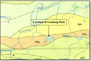
Figure 2. Geological Maps of Gondang Dam, Lamongan
The 1st International Conference on Energy & 7th Indonesia-Malaysia Geoheritage Conference
215 Based on the Geological Map Sheet Mojokerto by Y Noya et al (1992) above, the location of study have stratigraphic arrangements that composed by :
a. Lidah Formation (QTL), consist of claystone that have an insert of calcareous sandstones and limestones.
b. Pucangan Formation (QTp), which consist of breccia, tuffaceous sandstones that have insert of claystone and conglomerates.
c. Kabuh Formation (Qpk), consisting of sandstone, tuffaceous have an insert claystone, conglomerates and tuff.
d. Alluvium (Qal), consists of cobblestone, gravel, sand, silt, and mud.
Topographic conditions of Lamongan Regency can be viewed from a height region above sea level and slope steepness. Lamongan Regency consists of lowland and swampy with a height of 0-25 meters with an area of 50.17% of the total area, with a height of 25-100 meters land area of 45.68% and the remaining, 4.15%, is land with a height of over 100 meters from the surface sea water. Gondang Dam itself, including to area with low topography.
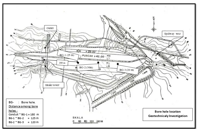
4.2 Result of Drilling
Drilling conducted at 3 points, there are BG-1 with a depth of 25 meters, BG-2 with
a depth of 30 meters, and BG-3 with a depth of 20 meters. The location of each drilling
point in Gondang Dam depicted in Figure 3.
Based on the drilling results in 3 points of Gondang Dam ( BG-1, BG-2, and BG-3), it can be seen the type of soil or rock as follows:
BG – 1
00.00 – 01.40 m Sand, loose, gray.
01.40 – 10.00 m Sandy clay (silt), stiff to very stiff, greyish-brown, the value of N (SPT) = 12-17.
10.00 – 16.00 m Clay, stiff to very stiff, gray-brown there is little sand, the value of N (SPT) = 16 - 18.
16.00 – 25.00 m Claystone, dense, gray-brown, the value of N (SPT) = 24 – 35
BG – 2
00.00 – 01.60 m Sand, loose, gray.
01.60 – 03.00 m Sandy clay(silt),stiffgray-brown, the value of N (SPT) = 15. 03.00 – 03.40 m Cobbly sand, stiff, brownish gray.
03.40 –06.45 m Sandy clay (silt), stiff, brownish gray, the value of N (SPT) = 15 -20.
06.45 – 27.00 m Clay, stiff-very stiff, gray-brown depths of 18-19, soft-stiff, the value of N (SPT) = 15 - 19.
The 1st International Conference on Energy & 7th Indonesia-Malaysia Geoheritage Conference
216 BG – 3
00.00 – 01.60 m Sand, solid half-off, greyish at a depth of 0 to 0.3 m are soil filler, and asphalt residua.
01.60 – 12.00 m Clay, gray-brown, stiff-very stiff, there is a little sand, the value of N (SPT) = 14-19.
12.00 – 20.00 m Claystone, dense, gray-brown, the value of N (SPT) = 20-34.
4.3 Test Laboratory
Soil mechanics laboratory tests of Gondang dam performed on 3 point drill, drill point BG-1 with a depth of 25 meters, BG-2 with a depth of 30 meters and BG-3 with a depth of 20 meters.
On laboratory analysis, the index test properties consisting of water content, unit weight, the specific gravity, grain size and atterberg, also mechanical properties consisting of Triaxial CU, Consolidation and permeability tests.
5. Conclusion
From the foregoing description can be summarized as follows:
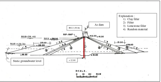
1. Gondang Dam is a earthdam, Zonal Dam type, Dam Core Vertical. At the core (impermeable zone) consists of silt and clay, including fine-grained soil. On the outside (pass zone) consists of a pile of limestone fragments.
2. Results of field investigation in the form of drilling, SPT, and permeability testing, soil / rock in Gondang Dam consists of :
The core of dam body
A fillof soil material, from top to the bottom, on BG-1 to a depth of 24 meters, the BG-2 to a depth of 27 meters, and the BG-3 to a depth of 12 meters, composed of :
Depth, on the BG-1: 0 - 1.4m; BG-2: 0 - 1.6 m; BG-3: 0 - 1.6 m: in the form of sand, gray, are off.
Depth, on BG-1 : 1,4 – 10 m; BG-2 : 1,6 -6,4 m : in the form of silt, brownish-gray colored, stiff to very stiff, the value of N (SPT) = 12-17.
Depth, on BG-1 10 – 16 m; BG-2 6,4 – 27 m; BG-3 1,6 – 12 m : in the form of clay, brownish-gray colored, stiff to very stiff, there is a little sand, the value of N (SPT) = 16-18.
Bedrock palm of dams (BG-1 at a depth of 16-25 m ; BG-2 at a depth of 27-30 m ;
BG-3 at a depth of 12-20 m) in the form:
The 1st International Conference on Energy & 7th Indonesia-Malaysia Geoheritage Conference
217 Core permeability coefficient dam body (soil embankment) ranged 2,34E-05 cm / sec - 5,49E-05 cm / sec, palms dam bedrock ranges 4,69E-05 cm / sec - 6,51E-05 cm / sec.
3. Based on the grain size, permeability values and the results of laboratory analysis of soil samples filler, it can be seen that the soil filler in dam core is still appropriate when applied as a soil filler material for impermeable zone on earth dam type.
References:
Ir. Shirley LH, 1987, Penuntun Praktis Geoteknik dan Mekanika Tanah (Penyelidikan Lapangan dan Laboratorium), NOVA – Bandung.
Ir. Suyono Sosrodarsono dan Kazuto Nakazawa, 1988, Mekanika Tanah & Teknik Pondasi, Cetakan 4, Pradnya Paramita, , Jakarta.
The 1st International Conference on Energy & 7th Indonesia-Malaysia Geoheritage Conference
218
Figure 3. Layout Drilling Point of Gondang Dam
Intake tower Outlet
Spillway weir
BG-1 (25 m)
BG-3 (20 m) BG-2 (30m)
Bore hole location Geotechnicaly Investigation
BG- : Bore hole. Distance among bore holes :
Conduit ~ BG-1 = 180 m BG-1 ~ BG-2 = 125 m BG-2 ~ BG-3 = 120 m
The 1st International Conference on Energy & 7th Indonesia-Malaysia Geoheritage Conference
219
Figure 4. Transverse pieces of Gondang Dam
BG-2 (30 m)
+ 12.00
Explanation : 1) Clay filler 2) Filter
3) Limestone filler 4) Random material As dam
The 1st International Conference on Energy & 7th Indonesia-Malaysia Geoheritage Conference