SPATIOTEMPORAL DATA ORGANIZATION AND APPLICATION RESEARCH
Chengguo Tan a, Suiyu Yan b* a
Big Data Innovation Center, State Key Laboratory of Information Engineering in Surveying, Mapping and Remote Sensing,Wuhan University, Wuhan, China - [email protected]
b Wuda Geoinformatics Co.,Ltd., Wuhan,China - [email protected]
Commission IV, WG IV/3
KEY WORDS: Spatiotemporal Data, Smart City, Information Fusion, Spatiotemporal Data Mining, Spatiotemporal Object
ABSTRACT:
Organization and management of spatiotemporal data is a key support technology for intelligence in all fields of the smart city. The construction of a smart city cannot be realized without spatiotemporal data. Oriented to support intelligent applications,this paper proposes an organizational model for spatiotemporal data, and details the construction of a spatiotemporal big data calculation, analysis, and service framework for highly efficient management and intelligent application of spatiotemporal data for the entire data life cycle.
* Corresponding author
1. INTRODUCTION
With the development of E-government infomationization in China, generally "two networks, one website, four databases, and twelve finance systems” have been gradually established and improved. All levels of E-government administration information systems have been promoted, while abundant data resources have accumulated through government duties and public services. However, data isolation is still a disadvantage. Different data resources do not interact so the value of these data can not be fully exploited. The State Council issued a "big data development promotion action plan" in August 2015 and "government information resources sharing management interim measures" in September 2016, in order to speed up the promotion of government information systems and public data sharing, enabling government information resources sharing to come inti full play for deepening reform, functional changes, and management innovations. The deep integration of existing urban management resources and urban information sharing has become one of the main tasks in smart city construction.
In the era of smart city and big data, spatiotemporal information permits an optimal allocation of urban resources, providing decision support to reduce the consumption and waste of urban resources. Spatiotemporal data mining facilitates traffic management, crime analysis, disease monitoring, environmental monitoring, public and medical health delivery and supports many other fields. All in all, there are a myrad of fields and practical motivations for analyzing massive and high-dimension spatiotemporal data and exploing the value of this data.
Guided by smart applications, this paper starts by addressing the problems of city and society information resources management, city operation system departmental collaboration and sharing. By analyzing the features of spatiotemporal data,
this paper defines the organization and analytical models of spatiotemporal data, constructing a spatiotemporal big data frame based on advanced techniques, such as smart network, cloud computing, and the Internet of Things(IoT), aiming at "full perception, interoperability, integration and sharing, business collaboration, on-demand services" . This orientation lays a conceptual foundation for data integration, management, service and application of city operation systems, that provide basic support for building a widely interconnected,deep application, and information service based smart city system.
2. THE ORGANIZATION OF SPATIOTEMPORAL DATA
Along with the development of urban informatization, sensor networks, mobile Internet, radio frequency identification, global positioning systems and other equipment have rapidly developed and become widely used, with explosive growth across time and space. The inherent time and space, properties of spatiotemporal data, are revealed in cubic dimensions, semantics, and dynamic landscapes with complex spatiotemporal correlations, which are time-variant, space-variant, dynamic and multi-dimensional.
2.1 Spatiotemporal data model
The core of spatiotemporal data is a geographic object. with a certain geographic meaning and uniqueness in space, corresponding to a complete equivalent in the real world, and also connected to related social economic information and featured with time dimension (T), space dimension (S) and property dimension (D).
A spatiotemporal model (table 1) includes a geographic object, event and procedure. A geographic object contains space, property and time information. Its changes in time and space can be measured, and described by events; the monitor monitors the change of the geographical object in space, attribute and
The International Archives of the Photogrammetry, Remote Sensing and Spatial Information Sciences, Volume XLII-2/W7, 2017 ISPRS Geospatial Week 2017, 18–22 September 2017, Wuhan, China
This contribution has been peer-reviewed.
triggers the geographical event according to the constraint rule in a certain time;reflected by geographic objects, procedures, and events, to construct models of dynamic landscapes with spatiotemporal correlations.
Figure 1 Logic model of spatiotemporal data
Geographic procedures reveal the outlines of the changes in space and time and the internal conditions within a geographic system [2]. The development of geographic objects in time dimension can be seen as a constantly process of change from one condition to the other. A change in the quality of a geographic object is called geographic event [3]. The production, development and offend of geographic object are caused by events. An inquiry into the qualities of change, the relationship, reason, and processes between geographic object and events can be explored and even predicted.
All geographic objects can be marked clearly with a time of production and end, based onlocal administrative standards.. After a geographic object ends, it will remain in the database as historical information.
2.2 Forecasting and alarm model
The Internet is abounds with spatiotemporal data accumulated in the fields of water pollution alarm and monitoring, city management, energy networks, and social spatial big data and so on. To construct spatiotemporal forecasting and alarm model to define the field and sequence in time and record the spatiotempral information for geographic objects according to different intelligent application needs.
Observation
Figure 2 Forecasting and alarm model of spatiotemporal data observation
The forecasting and alarm model (table 2) distils the mode, relation, changes and variation from the spatiotemporal data automatically; build space - time constraints, situation model and forms geographic event service. The observation connector extracts the temporal and spatial characteristics of a geographic object according to a certain time unit. The ontology model and the rule base for events are stored in the geographic event processor, which provides knowledge for determining abnormal events and deliver active warnings. It enables "real-time" perception, understanding, and prediction of the behaviors of geographical object trends; the output connector provides feedback to the service object as warnings.
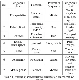
Observation connectors record spatiotemporal data with the interval of period, like a year, season, month, week, day, hour, minute and second[4]. According to different needs for geographic objects, the connector can be set to the corresponding frequency for observations and time items. At the same time, correspondinggeographic event must be defined according to the monitor task (Table 1).
No. Geographic
1 Transportation Location,
speed Minute
3 Logistics Transition
information Day
Trans post, sign up
4 Energy
consumption amount Hour, month
Peak,
6 Community Population Season
Move in, Table 1 Content of spatiotemporal observation on geographic
object
Geographical events cause a change in the state of the geographic object [5]. According to the change caused by the event, the change can be divided into three types: attribute change, geometric change and spatial position change. For attribute change, the change is the attribute of the space object, such as the change of the water quality, the change of the ownership, etc.; for the geometric change, the change is the geometric shape of the space object, such as the growth of the plant, widening of the road and so on; and for the spatial position change, the change is the spatial location of the object, such as the movement of object and so on.
2.3 Production and updating maintenance
In the process of urban government information management, , the definition of spatio-temporal data is to coordinate the cognitive differences of the main application departments, and obtain the largest common public expression of geographical elements[6] according to semantic understandings. At the same time, in accordance with the principle of "the department who is in charge of should provide information and be responsible for that" information, the providing departments need to implement unique space and time object ID for recognition and maintenance to ensure the authority and uniqueness of these space-time objects, and perform timely maintenance and information updates, to ensure the completeness, timeliness, and availability of the data. The using department should take use of shared space-time object information according to laws and regulations, for effective management during sharing and using, and updating. .
The International Archives of the Photogrammetry, Remote Sensing and Spatial Information Sciences, Volume XLII-2/W7, 2017 ISPRS Geospatial Week 2017, 18–22 September 2017, Wuhan, China
This contribution has been peer-reviewed.
In smart requirement applications, "bar data" from different departments are correlated with a unique ID and a time stamp field identifies the status of space-time objects. The observation sensor records time series values based on observation frequency. Then through deconstruction, crossover, fusion, and other processing appklied to these different types of "bar data", the integrated "block data" [7] of people, events, and things is formed. The process of block data collection involves filling the data space, the reconstruction of spatial data, the composition of the collection processes, and the collection of these composition processes. The analysis of the traces found in recorded spatiotemporal data can be used for making intelligent predictions of future social development trends.
3. SMART CITY SPATIOTEMPORAL DATA
Human activities occur, develop, and evolve in time and space. Nowdays there are more and more urban problems, such as traffic congestion, increased energy consumption, environmental degradation and so on. Spatio-temporal data can effectively alleviate the "urban diseases" of urban development, and supply an inherent power to city management applications. For example: atmospheric environmental monitoring, agricultural disaster monitoring, and traffic emergency command decision support [8].
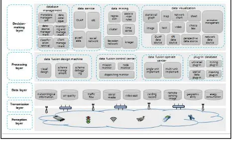
3.1 Urban spatiotemporal calculation frame
The basic framework for urban space-time calculation (Figure 3) includes: a perception layer, transmission layer, data layer, processing layer, and decision-making layer, forming a "real-time, sharing, integration, collaboration" urban management and operational framework.
Figure 3 City spatiotempral calculation frame
The sensing layer utilizes video surveillance, traffic jam data, social media, radio frequency identification, sensor, credit card readers, and remote sensing satellite information acquisition equipment to acquire perceptive data from all kinds of target objects in real time. With wired / wireless transmission technology, the acquired data is extended and expanded and connected to the Network layer for transmission. All kinds of spatio-temporal data is gathered to a big data center, and stored in the data warehouse together with the massive data in the data exchange center. Making use of spatial data analysis tools, data mining tools, visualization tools, can further achieve association, integration, collision, display and analysis, of spatiotemporal data , forming a dynamic map of urban signs. This achieves real-time monitoring, precision management, and scientific decision making[9] of the real world, for exploration
of the relationship between spatiotemporal behaviors and urban space [10], helping a city to realize smart city visions, such as a reasonable distribution of population, reasonable traffic arrangements, economic development, social progress, environmental protection, and he sustainable use of resources.
3.2 Spatiotemporal data application field
In the smart city system, population, resource use , commercial activities, space utilization, and industries are of high intensity. Energy, food, water and other elements come from outside of the area, therefore, the spatiotemporal factors become important to the economy, and infrastructure, Urban population, urban ecology, urban services, coordination and balanced development between the various systems. This theory applies to many cases of city land use, urban planning and design, public facilities management, traffic management, disaster early warning, crime analysis, disease monitoring, environmental monitoring, public health and health care and other fields [11].
4. APPLICATION RESEARCH ON SPATIOTEMPORAL DATA
4.1 Spatiotemporal data management tool
Based on above spatiotemporal data organization model and management method, a distributed database GeoTimeSeriesDB and a series of spatiotemporal data management tools for storing and retrieving spatiotemporal data were developed, including: geographic entity production tools, spatio-temporal database management system, and spatiotemporal data warehouse management system (Figure 4 and 5). They not only meet the entire life cycle management needs of spatiotemporal big data production process management, processing, distribution, integration and application of the data production management department, but also meet the data application department needs for spatiotemporal data integration with dynamic,real-time, timing, of popular, intelligent and user-friendly services, [12].
Figure 4 Spatiotemporal data management system
Figure 5 Spatiotemporal data warehouse management system
The International Archives of the Photogrammetry, Remote Sensing and Spatial Information Sciences, Volume XLII-2/W7, 2017 ISPRS Geospatial Week 2017, 18–22 September 2017, Wuhan, China
This contribution has been peer-reviewed.
4.2 Spatiotemporal data application cases
Geospatial data arecombined with other data that includes time and space attributes, such as population activities, social events, traffic and transportation, internet social, weather environment, agricultural production and economic development. By using Kriging interpolation, association rule analysis, time series, linear regression, Clustering analysis, Bayesian networks and other data mining model, the combined data are used for data analysis and mining, to provide decision-making support for the city commercial election, the relationship social analysis, drug user identification, transportation planning, and other applications.
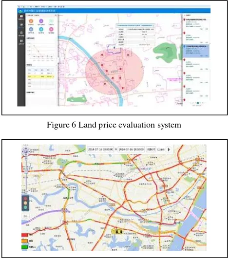
Based on the land price data of the sale contracts and the ground reference price data monitored by the monitoring stations in recent years, combined with the topographic data, the cooperative Kriging interpolation data mining models are used to forecast the unit price of the land, providing decision guidance for rational planning of urban land use (Figure 6).
Traffic data ia acquired through road sensors and vehicle GPS, this real-time city transportation data is analyzed and processed to create time city traffic congestion map. Meanwhile, real-time tracking and trajectory queries for selected vehicles can be based on the basic map, realizing effective supervision and dispatching of the selected vehicles, and alleviating city traffic congestion problems to improve urban operational efficiency (Figure 7).
Figure 6 Land price evaluation system
Figure 7 Real-time traffic congestion map
5. CONCLUSION
This paper focuses on the organization and management of spatiotemporal data, the design of a time and space framework for the intelligent city, and introduces the application of spatio temporal data with examples, laying the foundation for the construction and development of smart city infrastructure. The organization of spatiotemporal data in cities needs to be sorted
according to the needs of business applications, especially related to the management of time and space object identification, timing field and observation frequency. At the same time, it is necessary to further study the temporal and spatial data analysis methods and dynamic monitoring and evaluation models, especially the real-time data.
REFERENCES
Weisen Li. Digital China 's construction and the exploration of the city of wisdom [J]. Geographic Information World, 2013, 20 (2): 1-5.
Ying Zhao, Yanwei Chai, Jie Chen, et al. GIS analysis method of spatiotemporal behavior data [J]. Geography and Geoinformation Science, 2009, 29 (05): 1-5.
Xinbao Chen. Spatiotemporal data model of event and process and its time - dependent analysis model [Doctoral Dissertation]. Changsha: Central South University, 2011
Yunyan Guo, Quanhai Liu, Huimin Ran. Data management and visualization method under spatiotemporal information cloud platform [J]. Surveying Science, 2016 (10): 100-105.
Fei Liu, Zhenwen He, Xinqi Zheng. An event - based dual sequence spatiotemporal data model [J]. Geography and Geographic Information Science, 2015 (03): 1-6.
Shaoqin Chen. Basic geographic information database upgrade strategy [M]. New Normal Survey Geographic Information Research Report 2015, Social Science Literature Publishing House, 2015.
Gang Chen. Theoretical innovation and practical exploration of block data [J]. China Science and Technology Forum, 2015 (04): 46-50.
Deren Li, Jun Ma, Zhenfeng Shao. On spatiotemporal data and its application [J]. Satellite applications, 2015 (09): 07-11
Lei Yuan, Junsan Zhao, Hongbo Li. Analysis of Internet of Things spatial data warehouse framework and pipe fittings technology [J]. Geographic Information World, 2013 (01): 58-63.
Xiao Qin, Feng Zhen, Lifang Xiong, and so on. Study on urban spatial behavior in big data age [J]. Advances in Geography, 2013 (09): 1352-1361.
Zhong Wang, Zhihui An. Key cases and enlightenment of foreign city management big data application [J]. Modern Intelligence, 2016 (09): 168-172
Jianhua Xiao, Houzhi Wang, Qingshan Peng, et al. Geospatiotemporal data management and application cloud platform construction [J]. Bulletin of Surveying and Mapping, 2016 (4): 38-42.
The International Archives of the Photogrammetry, Remote Sensing and Spatial Information Sciences, Volume XLII-2/W7, 2017 ISPRS Geospatial Week 2017, 18–22 September 2017, Wuhan, China
This contribution has been peer-reviewed.