An EarthCube Technology Paper
Prepared by David Maidment1, Ben Domenico2, Alastair Gemmell3, Kerstin Lehnert4, David Tarboton5 and Ilya Zaslavsky6
OGC Document 11-159 18 October 2011
Introduction
EarthCube aims to create an integrated system to access, analyze and share information that is used by the entire geosciences community. The Open Geospatial Consortium (OGC) is an organization of which more than four hundred companies and agencies are members, whose purpose is to create open source standards for sharing geospatial and observational information. The authors of this paper are users of OGC standards in our work in hydrology, meteorology, climatology, oceanography and in the solid earth sciences, in other words, in key disciplinary fields that contribute to the Geosciences. Moreover, the OGC has an effective process for engaging individuals from many countries in standards development and interoperability testing that encourages them to set aside the roles they play in their home organizations and instead focus just on what is needed to share a particular class of information across the globe. This paper examines the hypothesis that an OGC-like process could be useful for broader sharing of information in the geosciences.
OGC Information Standards
The OGC has developed standards for sharing geospatial and observational information as web services. A web service is a function that enables one computer to make requests to another computer in a structured way and to receive appropriately coded responses in return. Sharing geoscience information requires the capacity to publish, catalog, discover, access and process information located on computers at any geographic location. OGC geospatial information service standards include:
• Web Map Service – for communicating georeferenced images;
• Web Feature Service – for communicating geospatial features as points, lines or areas with attached tabular attributes, that is, discrete spatial objects;
• Web Coverage Service – for communicating continuous spatial fields as multidimensional arrays.
• Web Processing Service – for executing functions or models on remote computers
The OGC information framework for observational data is founded on an observations and measurements model that has four key components – a feature of interest has properties that are observed by a process that produces a result. This model originated in the solid earth sciences
where it is used to describe properties of geological units (features of interest) via sampling features such as transects, wells, or specimens, but it has been generalized into the fluid domains where the feature of interest is understood to be a fluid domain in the vicinity of an observation instrument whose properties are being measured by that instrument. Sensor Web Enablement is a set of OGC specifications that define information encoding and service interfaces for
interacting with a network of sensors through internet, and within this there is a Sensor Observation Service that describes how to query and obtain information from a particular instrument.
An organization may provide access to a large number of web services, and to index them, OGC has developed a Catalog Services for the Web, which provides a single end-point web address through which the underlying services can be individually discovered and accessed, rather like going to the card catalog when entering a library in the traditional style.
Services in Solid Earth Science
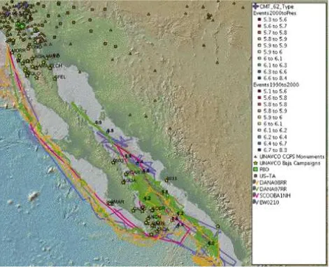
Geospatially referenced data in the Solid Earth Science are characterized by their highly diverse nature, ranging from large-volume sensor-based time series measurements to small but highly diverse and unstructured data generated ‘manually’ by investigators in the field or ex-situ in the lab. The integration of these heterogeneous data types is critical for many of the large scientific questions and challenges in the Solid Earth Sciences. Major NSF-funded science initiatives such as Ridge2000, GeoPrisms, and the Critical Zone Observatories require integration of multi-disciplinary datasets. OGC Web Map Service and Web Feature Service providers have
successfully been deployed by major Solid Earth Science data centers such as UNAVCO, IRIS, the Marine Geoscience Data System, the National Geophysical Data Center, and EarthChem to advance the integrated discovery and (Figure 1).
Figure 1. WMS and WFS features and layers include GPS campaign surveys and continuous stations, seismic stations, earthquake locations, seafloor bathymetry, expedition tracks.
A higher level of interoperability and data integration in the Solid Earth Sciences can be
achieved by applying the OGC Observation & Measurements (O&M) model to encode different types of observational data. White papers submitted by Rick Hooper and Ilya Zaslavsky
sensor-based and sample-sensor-based observational data. Several O&M profiling efforts are emerging in the Solid Earth Sciences (EarthChemXML, SoilML) and will complement existing standards such as WaterML 2.0 for hydrologic data and the Climate Science Modeling Language (CSML) for atmospheric and oceanographic data.
Services in Atmospheric Science
Standards play a key role in allowing the Unidata Program Center to make data available to other communities without diluting the support provided to the core community of researchers and educators in the atmospheric sciences. While it is not practical for the Unidata Program Center to support the specialized analysis and display tools of other disciplines, it is important to make the datasets available via standard protocols so users from these other disciplines can continue to make use of their own tailored analysis and display tools with data available from Unidata. Standards are also enabling Unidata to work with others who provide complementary functions.
Web Processing Services are emerging as a key element in distributed systems that enable more analysis and display functions to be performed on the server side. This has several advantages, for example, in the era of "big data," the processing can be done where the data reside. It also makes it feasible to initiate and control sophisticated interactive data analysis and processing from more modest mobile platforms. To gain a sense of power afforded by incorporating weather data into analyses done using tools from the GIS community, Figure 2 shows
demographic information as an overlay on real-time, high resolution, local forecast models being run in regions of high precipitation probability. The weather data is conveyed in netCDF
(network Common Data Form) via the OGC Web Coverage Service protocol. NetCDF is the first binary encoding format standard of the OGC.
Figure 2. ArcMap Rendering of Schools and Hospitals in a Region of High Precipitation
Services in Ocean Science
Over the last five to ten years in the ocean sciences there has been an increasingly strong
satellite-derived data products. Examples of such projects and applications include the Integrated Ocean Observing System – OpenIOOS, MyOcean (which employs the University of Reading’s ncWMS software), IMOS – the Australian Integrated Marine Observing System and the SeaDataNet project. More recently there has been an upsurge in the use of other OGC web service standards, including extensive use of the the OGC Sensor Web suite of standards, especially the Sensor Observation service (SOS). This is becoming the preferred way of serving in situ data streams in the marine community, as opposed to the Web Feature Service which is not as well suited to handling time series data. This is partly because the Web Feature Service standard is designed to serve features as a whole, and sub-setting is a common requirement in this type of service.
Projects and initiatives which have incorporated the use of the SOS standard include OOSTethys, OpenIOOS and the OGC Oceans Science Interoperability Experiment.
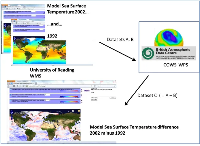
Figure 3 shows a Web Processing Service by which the difference between two sea surface temperature grids is computed – the request for the computation is initiated at the University of Reading, the calculation is done with the grids in netCDF format at the British Atmospheric Data Center, and the result is delivered back to the University of Reading as a Web Map Service.
Figure 3. Sea Surface Temperatures – a Web Processing Service delivers a Web Map Service
Services in Hydrologic Science
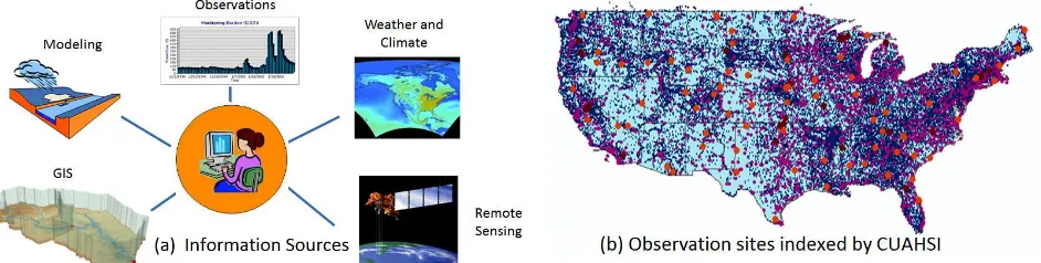
The Consortium of Universities for the Advancement of Hydrologic Science, Inc (CUAHSI) has invented a language, WaterML, for the communication of water observations data as a web service, and the US Geological Survey and some other water agencies have adopted WaterML and now publish their real-time and historical time series information in this format. CUAHSI has indexed water observations information at about 2.3 million locations in the US (Figure 4(b)), and provided access to this information in WaterML. Beginning in 2008, CUAHSI has been working with the OGC to modify WaterML, and a revised version, WaterML2, is being considered for adoption by the OGC as a profile or specialized version of the OGC Observations and Measurements specification, and thus as an international standard for encoding water observations data.
Figure 4. CUAHSI Hydrologic Information System
Geoscience Information Services
Any information system that emerges from EarthCube will build on the information infrastructure that NSF presently supports in the Geosciences. This includes several long-established data centers, such as the Unidata in Boulder and the IRIS Center in Seattle, and some newer initiatives including the CUAHSI Hydrologic Information System program and the
Integrated Earth Data Applications at the Lamont-Doherty Earth Observatory. Each of these activities focuses on the needs of a particular domain geoscience community and because
domain sciences tend to view the same physical circumstances in different ways, and even using different language, it is likely that there will always be the need for variations in terminology for different domain communities. This is similar to the task that the OGC deals with in
developing international standards in the face of different languages of the countries its members represent. At its core, however, information about the earth rests upon a physical model of the shape of the earth and of the evolution through time of the phenomena that take place on and within the surface of the earth, its atmosphere and oceans. This suggests that it is possible to develop a common set of Geoscience Information Services that the domain science communities could share.
confidence in data that have complete standards-compliant metadata, including QA/QC information (which is critical for establishing trust in such a diverse data-rich environment); ability to access data from anywhere in the system via common interfaces and bring them into applications that each discipline is familiar with. This vision, however, requires that the certain nodes in the EarthCube system (information hubs) are developed to support easy translation between disciplines. They would include services for translating structure, syntax and semantics between information models, services and vocabularies adopted by different domains, and would publish metadata catalogs that can be federated with metadata catalogs in other domains, for a one-stop data discovery and interpretation. In addition to “semantic web” elements, these
translations will be helped by scientists themselves who will be able to connect and explain their data via social networks. EarthCube is first and foremost about connecting people.
OGC Process
The OGC has two component programs, a Standards program and an Interoperability program, which develop standards and test them in practical situations. Standards development occurs by taking existing standards and developing more extensive specifications, or profiles, that serve particular purposes. Interoperability testing is carried out by interoperability experiments, pilot studies and testbeds, that represent successively increasing degrees of commitment and
involvement by the participant organizations in testing proposed standards. Domain working groups for particular disciplines focus activity in specialized areas of interest. The momentum of this activity is maintained by Technical Committee meetings that are held each three months at some location in the world, where standards are adopted and information exchanged in person among groups that otherwise communicate electronically.
Conclusions
The geosciences community embraces both the solid earth and fluid earth sciences and considers observed and modeled information distributed over the globe. Web services provide a
mechanism for one computer to request information from another in a structured way for a variety of information types. The Open Geospatial Consortium is an international standards organization for developing web services for geospatial and observational information, including standards for cataloging and processing that information, and has recently joined with the World Meteorological Organization to jointly develop standards for information in hydrology,
meteorology, climatology and oceanography. OGC standards are already fairly widely used in the NSF geosciences community. All these things suggest that EarthCube should seriously consider as one option for its development an OGC-based services-oriented architecture for the geosciences.