Open Geospatial Consortium Inc.
Date: 2008-02-18Reference number of this OGC™ Document: 07-067r3
Version: 1.1.2, Version 1.1 Corrigendum 2 release
Category: OGC™ Implementation Standard
Editors: Arliss Whiteside, John D. Evans
Web Coverage Service (WCS) Implementation
Standard
Copyright © 2007 Open Geospatial Consortium, Inc. All Rights Reserved. To obtain additional rights of use, visit http://www.opengeospatial.org/legal/.
Warning
This draft document is not yet an OGC Standard. It is distributed for review and comment. It is subject to change without notice and may not be referred to as an OGC Standard.
Recipients of this document are invited to submit, with their comments, notification of any relevant patent rights of which they are aware and to provide supporting
documentation.
Document type: OGC™ Implementation Standard
Document subtype: (none)
Document stage: Draft proposed version 1.1.2, Version 1.1 Corrigendum 2 release
OGC 07-067r3
Contents
Page
i. Preface ...x
ii. Document terms and definitions ...x
iii. Submitting organizations ...x
iv. Document contributors ...x
v. Revision history ...xi
vi. Changes to the OGC Abstract Specification ...xi
vii. Future work ...xii
1 Scope ...1
2 Conformance ...1
3 Normative references ...1
4 Terms and definitions ...2
5 Conventions ...3
5.1 Symbols (and abbreviated terms) ...3
5.2 UML notation ...3
5.3 Used parts of other documents ...3
5.4 Platform-neutral and platform-specific specifications ...4
5.5 Data dictionary tables ...4
6 WCS overview ...4
7 Shared aspects ...5
7.1 Introduction ...5
7.1.1 WCS XML MIME Type: application/x-wcs+xml ...5
7.2 Operation request encoding ...6
7.3 XML Schema notes ...6
7.4 Operation response encoding and reserved characters ...6
7.5 CRS definitions and references ...6
7.5.1 WCS use of CRSs ...6
7.5.2 CRS definitions ...6
7.5.3 CRS references ...7
7.5.4 ImageCRSs used in WCS ...8
7.5.5 GridCRSs used in WCS ...8
7.5.6 WCS use of GridCRSs ...9
7.5.7 Current WCS uses of CRSs ...10
7.6 BoundingBox use in WCS ...12
7.6.1 General terms ...12
7.6.2 Spanning the antimeridian of a geographic CRS ...13
7.6.3 Treatment of edge grid points ...13
8 GetCapabilities operation (mandatory) ...13
OGC 07-067r3
8.1 Introduction ...13
8.2 GetCapabilities operation request ...14
8.2.1 Request contents ...14
8.2.2 KVP encoding ...14
8.2.3 XML encoding ...14
8.2.4 SOAP encoding ...15
8.3 GetCapabilities operation response ...15
8.3.1 Normal response ...15
8.3.2 OperationsMetadata section contents ...16
8.3.2.1 Overview ...16
8.3.2.2 Indicating allowed encodings ...17
8.3.2.3 Indicating support for the “store” parameter ...17
8.3.3 Contents section ...17
8.3.3.1 Overview ...17
8.3.3.2 CoverageSummary ...19
8.3.3.3 Reserved characters in CoverageSummary parameter values ...21
8.3.3.4 CoverageSummary hierarchy ...21
8.3.3.5 OtherSource ...23
8.3.3.6 Implementation requirements ...23
8.3.3.7 XML encoding ...23
8.3.4 Capabilities document XML encoding ...23
8.3.5 Capabilities document SOAP encoding ...24
8.3.6 Exceptions ...24
8.4 GetCapabilities operation examples ...24
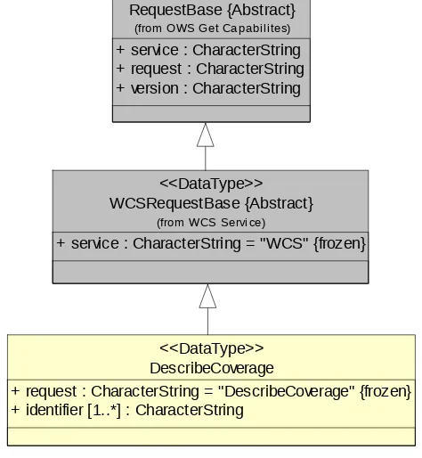
9 DescribeCoverage operation (mandatory) ...25
9.1 Introduction ...25
9.2 DescribeCoverage operation request ...25
9.2.1 DescribeCoverage request parameters ...25
9.2.2 DescribeCoverage request KVP encoding ...27
9.2.3 DescribeCoverage request XML encoding ...27
9.2.4 DescribeCoverage request SOAP encoding ...27
9.3 DescribeCoverage operation response ...27
9.3.1 Normal response parameters ...27
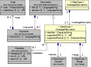
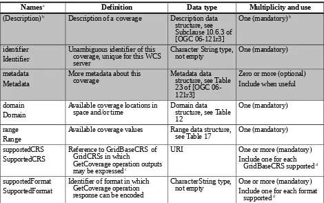
9.3.1.1 Coverage descriptions ...27
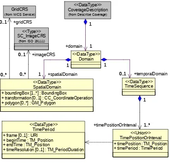
9.3.1.2 Domain of coverage ...29
9.3.1.3 Range of coverage ...32
9.3.1.4 Implementation requirements ...36
9.3.2 Supporting information ...37
9.3.2.1 Scalar and vector fields ...37
9.3.2.2 SupportedFormat ...38
9.3.2.3 Reserved characters in CoverageDescription parameter values ...38
9.3.2.4 Summary of ISO 8601 syntax for time positions and time periods ...38
9.3.3 Normal response XML encoding ...39
9.3.4 Normal response SOAP encoding ...39
9.4 DescribeCoverage exceptions ...39
9.5 DescribeCoverage operation examples ...40
10 GetCoverage operation (mandatory) ...41
OGC 07-067r3
10.1 Introduction ...41
10.2 GetCoverage operation request ...41
10.2.1 GetCoverage request parameters ...41
10.2.1.1 Overview ...41
10.2.1.2 RangeSubset ...44
10.2.1.3 Implementation requirements ...46
10.2.2 GetCoverage request KVP encoding ...47
10.2.2.1 Overview ...47
10.2.2.2 RangeSubset KVP syntax ...49
10.2.3 GetCoverage request XML encoding ...49
10.2.4 GetCoverage request SOAP encoding ...49
10.3 GetCoverage operation response ...49
10.3.1 Introduction ...49
10.3.2 GetCoverage exceptions ...50
10.3.3 Coverage processing ...50
10.3.4 Output Coverage ...51
10.3.4.1 Output coverage CRS ...51
10.3.4.2 Output coverage spatial extent ...51
10.3.4.3 Output coverage temporal extent ...52
10.3.4.4 Output coverage range ...52
10.3.4.5 Output coverage metadata ...53
10.3.4.6 Output coverage encoding ...53
10.4 Output coverage encoding extensions ...54
10.4.1 Introduction ...54
10.4.2 Identifying MIME type string ...55
10.4.3 Encoding extension specific request parameters ...55
10.4.4 STORE, FORMAT file count, and GetCoverage request encoding ...55
10.4.5 Stand alone XML encoded Coverages data structure response ...56
10.4.6 Single file response ...56
10.4.7 MIME multipart response ...56
10.4.8 SOAP response ...57
10.4.8.1 Stand alone SOAP message response ...57
10.4.8.2 SOAP with Attachments response ...57
10.4.9 Encoding extension limitations ...57
10.4.10 SupportedFormat and SupportedCRS dependencies ...58
10.5 GetCoverage operation examples ...58
10.5.1 A minimal GetCoverage request ...58
10.5.2 A longer GetCoverage request ...59
10.5.3 Another GetCoverage request ...60
10.5.4 Example responses ...60
Annex A (normative) Conformance ...62
Annex B (informative) WCS XML Schemas ...64
Annex C (informative) XML document examples ...65
C.1 Introduction ...65
C.2 GetCapabilities operation XML encoding examples ...65
C.3 DescribeCoverage operation XML encoding examples ...71
OGC 07-067r3
C.4 GetCoverage XML operation XML encoding examples ...71
Annex D (informative) UML model ...72
D.1 Introduction ...72
D.2 UML packages ...72
D.3 WCS Service package ...74
D.4 Get Coverage package ...74
D.5 Range Subset package ...76
D.6 Describe Coverage package ...76
D.7 Domain package ...78
D.8 Range package ...78
D.9 WCS Get Capabilities package ...81
D.10 WCS Contents package ...82
Annex E (normative) SOAP transfer ...83
Annex F (normative) GridCRS ...84
F.1 Introduction ...84
F.2 GridCRS ...84
F.2.1 GridCRS contents ...84
F.2.2 GridCRS coordinates ...85
F.2.3 Default values ...86
F.2.4 XML encoding ...86
F.2.5 KVP encoding ...87
F.3 Operation methods for rectangular grids ...88
F.3.1 Introduction ...88
F.3.2 2D grid in 2D CRS (urn:ogc:def:method:WCS:1.1:2dGridIn2dCrs) ...88
F.3.3 2D grid in 3D CRS (urn:ogc:def:method:WCS:1.1:2dGridIn3dCrs) ...89
F.3.4 2D simple grid (urn:ogc:def:method:WCS:1.1:2dSimpleGrid) ...91
Annex G (informative) GetCoverage use cases ...94
G.1 Introduction ...94
G.2 Use cases ...94
G.2.1 Overview ...94
G.2.2 Use case 1: No resampling of georectified coverage, defining extent in ground CRS ...95
G.2.3 Use case 2: No resampling of georectified image, defining extent in grid CRS ...95
G.2.4 Use case 3: No resampling of unrectified and un-georeferenced image ...95
G.2.5 Use case 4: No resampling of unrectified but georeferenced image, defining extent in grid CRS ...96
G.2.6 Use case 5: No resampling of unrectified but georeferenced image, defining extent in ground CRS ...96
G.2.7 Use case 6: Resampling of georectified coverage, defining extent in ground CRS ...96
G.2.8 Use case 7: Resampling of georectified image, defining extent in grid CRS ...97
G.2.9 Use case 8: Resampling of unrectified and un-georeferenced image ...97
G.2.10 Use case 9: Resampling of unrectified but georeferenced image, defining extent in grid CRS ...97
OGC 07-067r3
G.2.11 Use case 10: Resampling of unrectified but georeferenced image,
defining extent in ground CRS ...97
G.2.12 Addition A ...98
G.3 Handling of use cases ...99
G.3.1 Overview ...99
G.3.2 Use case 1: No resampling of georectified coverage, defining extent in ground CRS ...102
G.3.3 Use case 2: No resampling of georectified image, defining extent in grid CRS ...103
G.3.4 Use case 3: No resampling of unrectified and un-georeferenced image ...104
G.3.5 Use case 4: No resampling of unrectified but georeferenced image, defining extent in grid CRS ...105
G.3.6 Use case 5: No resampling of unrectified but georeferenced image, defining extent in ground CRS ...106
G.3.7 Use case 6: Resampling of georectified coverage, defining extent in ground CRS ...107
G.3.8 Use case 7: Resampling of georectified image, defining extent in grid CRS ...108
G.3.9 Use case 8: Resampling of unrectified and un-georeferenced image ...109
G.3.10 Use case 9: Resampling of unrectified but georeferenced image, defining extent in grid CRS ...110
G.3.11 Use case 10: Resampling of unrectified but georeferenced image, defining extent in ground CRS ...111
G.3.12 Addition B ...113
G.3.13 GridCRS identifiers ...113
Annex H (normative) Other data structures ...114
H.1 Overview ...114
H.2 Coverages data structure ...114
H.2.1 Introduction ...114
H.2.2 XML encoding ...115
H.3 Interpolation methods ...116
H.3.1 Interpolation methods contents ...116
H.3.2 Interpolation methods XML encoding ...118
H.3.3 Interpolation method KVP encoding ...119
Bibliography ...120
i. Preface ...x
ii. Document terms and definitions ...x
iii. Submitting organizations ...x
iv. Document contributors ...x
v. Revision history ...xi
vi. Changes to the OGC Abstract Specification ...xi
vii. Future work ...xii
OGC 07-067r3
1 Scope ...1
2 Conformance ...1
3 Normative references ...1
4 Terms and definitions ...2
5 Conventions ...3
5.1 Symbols (and abbreviated terms) ...3
5.2 UML notation ...3
5.3 Used parts of other documents ...3
5.4 Platform-neutral and platform-specific specifications ...3
5.5 Data dictionary tables ...4
6 WCS overview ...4
7 Shared aspects ...5
7.1 Introduction ...5
7.2 Operation request encoding ...5
7.3 XML Schema notes ...5
7.4 Operation response encoding and reserved characters ...6
7.5 CRS definitions and references ...6
7.5.1 WCS use of CRSs ...6
7.5.2 CRS definitions ...6
7.5.3 CRS references ...7
7.5.4 ImageCRSs used in WCS ...7
7.5.5 GridCRSs used in WCS ...8
7.5.6 WCS use of GridCRSs ...9
7.5.7 Current WCS uses of CRSs ...10
7.6 BoundingBox use in WCS ...12
7.6.1 General terms ...12
7.6.2 Spanning the antimeridian of a geographic CRS ...12
7.6.3 Treatment of edge grid points ...13
8 GetCapabilities operation (mandatory) ...13
8.1 Introduction ...13
8.2 GetCapabilities operation request ...13
8.2.1 Request contents ...13
8.2.2 KVP encoding ...14
8.2.3 XML encoding ...14
8.2.4 SOAP encoding ...15
8.3 GetCapabilities operation response ...15
8.3.1 Normal response ...15
8.3.2 OperationsMetadata section contents ...16
8.3.2.1 Overview ...16
8.3.2.2 Indicating allowed encodings ...17
8.3.2.3 Indicating support for the “store” parameter ...17
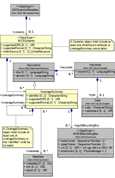
8.3.3 Contents section ...17
8.3.3.1 Overview ...17
8.3.3.2 CoverageSummary ...19
8.3.3.3 Reserved characters in CoverageSummary parameter values ...21
OGC 07-067r3
8.3.3.4 CoverageSummary hierarchy ...21
8.3.3.5 OtherSource ...23
8.3.3.6 Implementation requirements ...23
8.3.3.7 XML encoding ...23
8.3.4 Capabilities document XML encoding ...24
8.3.5 GetCapabilities document SOAP encoding ...24
8.3.6 Exceptions ...24
8.4 GetCapabilities operation examples ...24
9 DescribeCoverage operation (mandatory) ...25
9.1 Introduction ...25
9.2 DescribeCoverage operation request ...25
9.2.1 DescribeCoverage request parameters ...25
9.2.2 DescribeCoverage request KVP encoding ...27
9.2.3 DescribeCoverage request XML encoding ...27
9.2.4 DescribeCoverage request SOAP encoding ...27
9.3 DescribeCoverage operation response ...27
9.3.1 Normal response parameters ...27
9.3.1.1 Coverage descriptions ...27
9.3.1.2 Domain of coverage ...29
9.3.1.3 Range of coverage ...32
9.3.1.4 Implementation requirements ...36
9.3.2 Supporting information ...37
9.3.2.1 Scalar and vector fields ...37
9.3.2.2 SupportedFormat ...38
9.3.2.3 Reserved characters in CoverageDescription parameter values ...39
9.3.2.4 Summary of ISO 8601 syntax for time positions and time periods ...39
9.3.3 Normal response XML encoding ...40
9.3.4 Normal response SOAP encoding ...40
9.4 DescribeCoverage exceptions ...40
9.5 DescribeCoverage operation examples ...41
10 GetCoverage operation (mandatory) ...42
10.1 Introduction ...42
10.2 GetCoverage operation request ...43
10.2.1 GetCoverage request parameters ...43
10.2.1.1 Overview ...43
10.2.1.2 RangeSubset ...45
10.2.1.3 Implementation requirements ...47
10.2.2 GetCoverage request KVP encoding ...48
10.2.2.1 Overview ...48
10.2.2.2 RangeSubset KVP syntax ...50
10.2.3 GetCoverage request XML encoding ...50
10.2.4 GetCoverage request SOAP encoding ...51
10.3 GetCoverage operation response ...51
10.3.1 Introduction ...51
10.3.2 GetCoverage exceptions ...51
10.3.3 Coverage processing ...51
10.3.4 Output coverage CRS ...52
OGC 07-067r3
10.3.5 SupportedFormat and SupportedCRS dependencies ...53
10.3.6 Output coverage spatial extent ...53
10.3.7 Output coverage temporal extent ...53
10.3.8 Output coverage range ...54
10.3.9 Output coverage metadata ...54
10.3.10 Output coverage formats ...55
10.3.11 Response encodings ...55
10.3.11.1 Overview ...55
10.3.11.2 Coverages data structure ...56
10.3.11.3 MIME multipart response ...57
10.3.11.4 SOAP response ...57
10.3.11.5 SOAP with Attachments response ...57
10.3.12 Coverages XML encoding ...57
10.4 GetCoverage operation examples ...58
10.4.1 A minimal GetCoverage request ...58
10.4.2 A longer GetCoverage request ...58
10.4.3 Another GetCoverage request ...60
10.4.4 Example responses ...60
Annex A (normative) Conformance ...62
Annex B (informative) WCS XML Schemas ...64
Annex C (informative) XML document examples ...65
C.1 Introduction ...65
C.2 GetCapabilities operation XML encoding examples ...65
C.3 DescribeCoverage operation XML encoding examples ...71
C.4 GetCoverage XML operation XML encoding examples ...71
Annex D (informative) UML model ...72
D.1 Introduction ...72
D.2 UML packages ...72
D.3 WCS Service package ...74
D.4 Get Coverage package ...74
D.5 Range Subset package ...76
D.6 Describe Coverage package ...76
D.7 Domain package ...78
D.8 Range package ...78
D.9 WCS Get Capabilities package ...81
D.10 WCS Contents package ...82
Annex E (normative) SOAP transfer ...84
Annex F (normative) GridCRS ...85
F.1 Introduction ...85
F.2 GridCRS ...85
F.2.1 GridCRS contents ...85
F.2.2 GridCRS coordinates ...87
F.2.3 Default values ...88
F.2.4 XML encoding ...88
F.2.5 KVP encoding ...89
OGC 07-067r3
F.3 Operation methods for rectangular grids ...90
F.3.1 Introduction ...90
F.3.2 2D grid in 2D CRS (urn:ogc:def:method:WCS:1.1:2dGridIn2dCrs) ...90
F.3.3 2D grid in 3D CRS (urn:ogc:def:method:WCS:1.1:2dGridIn3dCrs) ...91
F.3.4 2D simple grid (urn:ogc:def:method:WCS:1.1:2dSimpleGrid) ...93
Annex G (informative) GetCoverage use cases ...96
G.1 Introduction ...96
G.2 Use cases ...96
G.2.1 Overview ...96
G.2.2 Use case 1: No resampling of georectified coverage, defining extent in ground CRS ...97
G.2.3 Use case 2: No resampling of georectified image, defining extent in image CRS ...97
G.2.4 Use case 3: No resampling of unrectified and un-georeferenced image ...97
G.2.5 Use case 4: No resampling of unrectified but georeferenced image, defining extent in image CRS ...98
G.2.6 Use case 5: No resampling of unrectified but georeferenced image, defining extent in ground CRS ...98
G.2.7 Use case 6: Resampling of georectified coverage, defining extent in ground CRS ...99
G.2.8 Use case 7: Resampling of georectified image, defining extent in image CRS ...99
G.2.9 Use case 8: Resampling of unrectified and un-georeferenced image ...99
G.2.10 Use case 9: Resampling of unrectified but georeferenced image, defining extent in image CRS ...100
G.2.11 Use case 10: Resampling of unrectified but georeferenced image, defining extent in ground CRS ...100
G.2.12 Addition A ...100
G.3 Handling of use cases ...101
G.3.1 Overview ...101
G.3.2 Use case 1: No resampling of georectified coverage, defining extent in ground CRS ...105
G.3.3 Use case 2: No resampling of georectified image, defining extent in image CRS ...106
G.3.4 Use case 3: No resampling of unrectified and un-georeferenced image ...107
G.3.5 Use case 4: No resampling of unrectified but georeferenced image, defining extent in image CRS ...108
G.3.6 Use case 5: No resampling of unrectified but georeferenced image, defining extent in ground CRS ...109
G.3.7 Use case 6: Resampling of georectified coverage, defining extent in ground CRS ...110
G.3.8 Use case 7: Resampling of georectified image, defining extent in image CRS ...111
G.3.9 Use case 8: Resampling of unrectified and un-georeferenced image ...112
G.3.10 Use case 9: Resampling of unrectified but georeferenced image, defining extent in image CRS ...114
OGC 07-067r3
G.3.11 Use case 10: Resampling of unrectified but georeferenced image,
defining extent in ground CRS ...115
G.3.12 Addition B ...116
Annex H (normative) Other data structures ...117
H.1 Overview ...117
H.2 Coverages data structure ...117
H.2.1 Introduction ...117
H.2.2 XML encoding ...118
H.3 Interpolation methods ...119
H.3.1 Interpolation methods contents ...119
H.3.2 Interpolation methods XML encoding ...121
H.3.3 Interpolation method KVP encoding ...122
Bibliography ...123
OGC 07-067r3
Figures
Page
Figure 1 — WCS interface UML class diagram ...5
Figure 2 — Grid points, grid cells, and sample spaces ...12
Figure 3 — WCS Service Metadata UML class diagram ...15
Figure 4 — Contents UML class diagram ...18
Figure 5 — DescribeCoverage operation request UML class diagram ...26
Figure 6 — DescribeCoverage operation response UML class diagram ...28
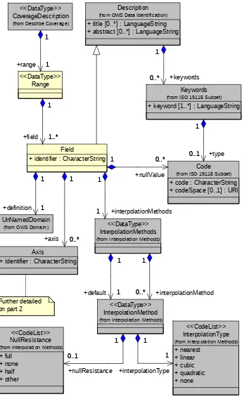
Figure 7 — Domain UML class diagram ...30
Figure 8 — Range UML class diagram, part 1 ...33
Figure 9 — Range UML class diagram, part 2 ...34
Figure 10 — Example vector fields ...37
Figure 11 — GetCoverage request UML class diagram ...42
Figure 12 — RangeSubset UML class diagram ...45
Figure 13 — Conceptual GetCoverage request evaluation sequence ...51
Figure D.1 — WCS interface UML class diagram ...72
Figure D.2 — WCS interface package diagram ...73
Figure D.3 — WCS Service package class diagram ...74
Figure D.4 — Get Coverage package class diagram ...75
Figure D.5 — Range Subset package class diagram ...76
Figure D.6 — Describe Coverage package class diagram ...77
Figure D.7 — Domain package class diagram ...78
Figure D.8 — Range package class diagram, part 1 ...79
Figure D.9 — Range package class diagram, part 2 ...80
Figure D.10 — WCS Get Capabilities package class diagram ...81
Figure D.11 — WCS Contents package class diagram ...82
Figure F.1 — GridCRS class diagram ...84
Figure G.1 — Parallelogram grid within a 2D X-Y space ...98
Figure H.1 — Coverages package UML diagram ...115
Figure H.2 — Interpolation Methods class diagram ...116
Figure 1 — WCS interface UML class diagram ...5
Figure 2 — Grid points, grid cells, and sample spaces ...12
Figure 3 — WCS Service Metadata UML class diagram ...15
Figure 4 — Contents UML class diagram ...18
Figure 5 — DescribeCoverage operation request UML class diagram ...26
OGC 07-067r3
Figure 6 — DescribeCoverage operation response UML class diagram ...28
Figure 7 — Domain UML class diagram ...30
Figure 8 — Range UML class diagram, part 1 ...33
Figure 9 — Range UML class diagram, part 2 ...34
Figure 10 — Example vector fields ...37
Figure 11 — GetCoverage request UML class diagram ...43
Figure 12 — RangeSubset UML class diagram ...46
Figure 13 — Conceptual GetCoverage request evaluation sequence ...52
Figure D.1 — WCS interface UML class diagram ...72
Figure D.2 — WCS interface package diagram ...73
Figure D.3 — WCS Service package class diagram ...74
Figure D.4 — Get Coverage package class diagram ...75
Figure D.5 — Range Subset package class diagram ...76
Figure D.6 — Describe Coverage package class diagram ...77
Figure D.7 — Domain package class diagram ...78
Figure D.8 — Range package class diagram, part 1 ...79
Figure D.9 — Range package class diagram, part 2 ...80
Figure D.10 — WCS Get Capabilities package class diagram ...81
Figure D.11 — WCS Contents package class diagram ...83
Figure F.1 — GridCRS class diagram ...86
Figure G.1 — Parallelogram grid within a 2D X-Y space ...101
Figure H.1 — Coverages package UML diagram ...118
Figure H.2 — Interpolation Methods class diagram ...119
OGC 07-067r3
Tables
Page
Table 1 — WCS uses of CRSs ...11
Table 2 — Implementation of parameters in GetCapabilities operation request ...14
Table 3 — Section name values and contents ...16
Table 4 — Required values of OperationsMetadata section attributes ...16
Table 5 — Parts of Contents section ...19
Table 6 — CoverageSummary data structure ...20
Table 7 — Inheritance of parts of CoverageSummary data structure ...22
Table 8 — Parameters in DescribeCoverage operation request ...26
Table 9 — DescribeCoverage request URL encoding ...27
Table 10 — Parts of CoverageDescriptions data structure ...28
Table 11 — Parts of CoverageDescription data structure ...29
Table 12 — Parts of Domain data structure ...30
Table 13 — Parts of SpatialDomain data structure ...31
Table 14 — Parts of TimeSequence data structure ...32
Table 15 — Parts of TimePositionOrInterval data structure ...32
Table 16 — Parts of TimePeriod data structure ...32
Table 17 — Parts of Range data structure ...34
Table 18 — Parts of Field data structure ...35
Table 19 — Parts of Axis data structure ...36
Table 20 — Parts of AvailableKeys data structure ...36
Table 21 — Exception codes for DescribeCoverage operation ...40
Table 22 — Parts of GetCoverage operation request ...43
Table 23 — Parts of DomainSubset data structure ...44
Table 24 — Parts of Output data structure ...44
Table 25 — Parts of RangeSubset data structure ...45
Table 26 — Parts of FieldSubset data structure ...45
Table 27 — Parts of AxisSubset data structure ...46
Table 28 — GetCoverage request expressed as Key Value Pairs ...48
Table 29 — Exception codes for GetCoverage operation ...50
Table 30 — Required output coverage metadata ...53
Table 31 — GetCoverage multiple file output coverage encodings ...56
Table F.1 — Parameters in GridCRS data structure ...85
Table F.2 — GridCRS default values ...86
OGC 07-067r3
Table F.3 — GridCRS encoded as Key Value Pairs ...87
Table G.1 — GetCoverage use case numbers for combinations of conditions ...94
Table G.2 — GetCoverage request DomainSubset BoundingBox CRS for use cases ...99
Table G.3 — GetCoverage request Output CRS for use cases ...100
Table G.4 — GetCoverage response BoundingBox CRS for use cases ...101
Table H.1 — Parts of the InterpolationMethods data structure ...117
Table H.2 — Parts of the InterpolationMethod data structure ...117
Table H.3 — Normal spatial interpolation types ...118
Table H.4 — Effect of null values in spatial interpolation ...118
Table 1 — WCS uses of CRSs ...11
Table 2 — Implementation of parameters in GetCapabilities operation request ...14
Table 3 — Section name values and contents ...16
Table 4 — Required values of OperationsMetadata section attributes ...16
Table 5 — Parts of Contents section ...19
Table 6 — CoverageSummary data structure ...20
Table 7 — Inheritance of parts of CoverageSummary data structure ...22
Table 8 — Parameters in DescribeCoverage operation request ...26
Table 9 — DescribeCoverage request URL encoding ...27
Table 10 — Parts of CoverageDescriptions data structure ...28
Table 11 — Parts of CoverageDescription data structure ...29
Table 12 — Parts of Domain data structure ...30
Table 13 — Parts of SpatialDomain data structure ...31
Table 14 — Parts of TimeSequence data structure ...32
Table 15 — Parts of TimePositionOrInterval data structure ...32
Table 16 — Parts of TimePeriod data structure ...32
Table 17 — Parts of Range data structure ...34
Table 18 — Parts of Field data structure ...35
Table 19 — Parts of Axis data structure ...36
Table 20 — Parts of AvailableKeys data structure ...36
Table 21 — Exception codes for DescribeCoverage operation ...41
Table 22 — Parts of GetCoverage operation request ...44
Table 23 — Parts of DomainSubset data structure ...45
Table 24 — Parts of Output data structure ...45
Table 25 — Parts of RangeSubset data structure ...46
Table 26 — Parts of FieldSubset data structure ...46
OGC 07-067r3
Table 27 — Parts of AxisSubset data structure ...47
Table 28 — GetCoverage request expressed as Key Value Pairs ...49
Table 29 — Exception codes for GetCoverage operation ...51
Table 30 — Required output coverage metadata ...55
Table 31 — GetCoverage response encodings ...56
Table F.1 — Parameters in GridCRS data structure ...87
Table F.2 — GridCRS default values ...88
Table F.3 — GridCRS encoded as Key Value Pairs ...89
Table G.1 — GetCoverage use case numbers for combinations of conditions ...96
Table G.2 — GetCoverage request DomainSubset BoundingBox CRS for use cases ...102
Table G.3 — GetCoverage request Output CRS for use cases ...103
Table G.4 — GetCoverage response BoundingBox CRS for use cases ...104
Table H.1 — Parts of the InterpolationMethods data structure ...120
Table H.2 — Parts of the InterpolationMethod data structure ...120
Table H.3 — Normal spatial interpolation types ...121
Table H.4 — Effect of null values in spatial interpolation ...121
OGC 07-067r3
i.
Preface
This is WCS version 1.1.2, or version 1.1 Corrigendum 2 release, and builds WCS version 1.1.0 [OGC 06-083r8] and 1.1.1 [OGC 07-067r2]. It also builds on on OWS Common
version 1.1.0 [OGC06-121r3].
ii.
Document terms and definitions
This document uses the specification terms defined in Subclause 5.3 of [OGC 06-121r3], which is based on the ISO/IEC Directives, Part 2, Rules for the structure and drafting of International Standards. In particular, the word “shall” (not “must”) is the verb form used to indicate a requirement to be strictly followed to conform to this specification.
iii.
Submitting organizations
The following organizations have submitted this Implementation Specification to the Open Geospatial Consortium, Inc.
BAE SYSTEMS E&IS
Australia Commonwealth Scientific and Industrial Research Organisation (CSIRO) CubeWerx Inc.
George Mason University
Jacobs University Bremen / rasdaman GmBH
IONIC SOFTWARE s.a.
U.S. National Aeronautics and Space Administration (NASA)
U.S. National Geospatial-Intelligence Agency (NGA)
Oracle Corp. PCI Geomatics
iv.
Document contributors
OGC’s Web Coverage Service 1.1 Revision Working Group members are listed below.
Name Organization
Baumann, Peter Jacobs University Bremen / rasdaman GmBH
Cox, Simon CSIRO
Di, Liping George Mason University
Donéa, Luc IONIC SOFTWARE
Evans, John NASA / GST, Inc
Herring, John Oracle Corporation
Keens, Steven PCI Geomatics
Roswell, Charles NGA
Vretanos, Panagiotis CubeWerx, Inc. Whiteside, Arliss BAE Systems E&IS
OGC 07-067r3
v.
Revision history
This WCS version 1.1.2 is Corrigendum 2 of WCS 1.1, as documented in [OGC 07-066r3], further correcting WCS 1.1.1 (Corrigendum 1 of WCS 1.1). Corrigendum 2 fixes minor inconsistencies, spelling mistakes, and adds some minor clarifications.
WCS 1.1.1 was Corrigendum 1 of WCS 1.1, as documented in [OGC 07-066r2]. Briefly, the changes were:
a) Fixed minor inconsistencies, spelling mistakes, and added some minor clarifications b) Aligned with OWS-Common version 1.1.0
WCS 1.1.0 was almost a complete rewrite of WCS 1.0.0, with many editorial changes and detailed streamlining of schema files resulting from OWS Common conformance. However, the two versions of the specification share the same overall structure. WCS 1.1.0 introduced (only) the following functional changes:
a) Use of GridCRS in coverage descriptions and requests
(See 9.3.1.2, 10.2.1.1, 10.2.2, 10.3.4, 10.3.6, and Annexes F and G)
b) Hierarchical coverage descriptions (See 8.3.4.4) c) Multiple fields per coverage
(See 9.3.1.3, 9.3.2.1, 10.2.1.2, 10.2.2.1, 10.2.2.2, and Tables 18, 26-29) d) XML and (optionally) asynchronous GetCoverage responses (See 10.3.11)
e) Different approach to coverage formats; reliance on encoding profiles (See 9.3.2.2) Many of the changes were the direct or indirect result of addressing written change proposals, as summarized in OGC 06-116.
vi.
Changes to the OGC Abstract Specification
OGC™ Abstract Specification Topic 6: The Coverage Type and its Subtypes (which includes ISO 19123) requires the following change to accommodate the technical contents of this document:
Spatial interpolation needs to be a property of each field in the range of a coverage, not a property of the coverage or of its range as a whole. Currently, the interpolationType is an attribute of the CV_ContinuousQuadrilateralGridCoverage class, which is associated to one CV_GridValuesMatrix. This CV_GridValuesMatrix contains a sequence of values of Record type, where each Record can contain multiple “fields”. However, different fields may require the use of different interpolation types; and more than one interpolation method may be associated with a single field.
OGC 07-067r3
vii.
Future work
Future versions of this WCS specification are expected to consider various expansions of the abilities specified herein, some adding abilities that were deliberately not included in Version 1.1.0. Some of the possible expansions thus include:
a) Expand supported coverage types beyond grid coverages.
b) Expand ability to retrieve elevation subset of a coverage, beyond current regularly spaced (grid) elevations.
c) Expand ability to retrieve spatial subset of a coverage, beyond current regularly spaced (grid) positions.
d) Expand ability to store coverage outputs, for later retrieval. e) Add WSDL description of SOAP encodings
f) Add ability to Retrieve multiple coverages in one GetCoverage operation request
g) Add optional interface operation(s) to input new coverages and update existing coverages offered by a WCS server
h) Expand Annex A to specify abstract test suites.
OGC 07-067r3
Foreword
This version 1.1.1 of the Web Coverage Service (WCS) Specification supersedes previous version 1.1.0 [OGC 06-083r8]. Technical changes from the version 1.0 include building on the OGC Web Services Common Specification [OGC 06-121r3] and a substantially revised Capabilities schema; new schemas and syntax for operation requests (GetCoverage, DescribeCoverage); and integration with GML 3.1. The changes in WCS 1.1.1 from WCS 1.1.0 are summarized in [OGC 07-066].
This document includes eight annexes; Annexes A, E, F, and H are normative, and Annexes B, C, D, and G are informative.
Attention is drawn to the possibility that some of the elements of this document may be the subject of patent rights. The Open Geospatial Consortium Inc. shall not be held responsible for identifying any or all such patent rights.
Recipients of this document are requested to submit, with their comments, notification of any relevant patent claims or other intellectual property rights of which they may be aware that might be infringed by any implementation of the standard set forth in this document, and to provide supporting documentation.
OGC 07-067r3
Introduction
The Web Coverage Service (WCS) supports electronic retrieval of geospatial data as "coverages" – that is, digital geospatial information representing space-varying phenomena.
A WCS provides access to potentially detailed and rich sets of geospatial information, in forms that are useful for client-side rendering, multi-valued coverages, and input into scientific models and other clients. The WCS may be compared to the OGC Web Map Service (WMS) and the Web Feature Service (WFS); like them it allows clients to choose portions of a server's information holdings based on spatial constraints and other criteria.
Unlike the WMS [OGC 06-042], which portrays spatial data to return static maps (rendered as pictures by the server), the Web Coverage Service provides available data together with their detailed descriptions; defines a rich syntax for requests against these data; and returns data with its original semantics (instead of pictures) which may be interpreted, extrapolated, etc. – and not just portrayed.
Unlike WFS [OGC 04-094], which returns discrete geospatial features, the Web Coverage Service returns coverages representing space-varying phenomena that relate a spatio-temporal domain to a (possibly multidimensional) range of properties.
The Web Coverage Service provides three operations: GetCapabilities, DescribeCoverage,
and GetCoverage. The GetCapabilities operation returns an XML document describing the service and brief descriptions of the coverages that clients may request. Clients would generally run the GetCapabilities operation and cache its result for use throughout a session, or reuse it for multiple sessions. When the GetCapabilities operation does not return such descriptions, then equivalent information must be available from a separate source, such as an image catalog.
The DescribeCoverage operation lets clients request a full description of one or more coverages served by a particular WCS server. The server responds with an XML document that fully describes the identified coverages.
The GetCoverage operation is normally run after GetCapabilities and DescribeCoverage
operation responses have shown what requests are allowed and what data are available. The
GetCoverage operation returns a coverage (that is, values or properties of a set of geographic locations), encoded in a well-known coverage format. Its syntax and semantics bear some resemblance to the WMS GetMap and WFS GetFeature requests, but several extensions support the retrieval of coverages rather than static maps or discrete features.
OpenGIS® Implementation Specification OGC 07-067r3
Web Coverage Service (WCS) Implementation Standard
1 Scope
This document specifies how a Web Coverage Service (WCS) describes and delivers multi-dimensional coverage data over the World Wide Web. This version of the Web Coverage Service is limited to describing and requesting grid (or "simple”) coverages.
Grid coverages have a domain comprised of regularly spaced locations along 0, 1, 2, or 3 axes of a spatial coordinate reference system. Their domain may also have a time dimension, which may be regularly or irregularly spaced. A coverage defines, at each location in the domain, a set of fields that may be scalar-valued (such as elevation), or vector-valued (such as brightness values in different parts of the electromagnetic spectrum). These fields (and their values) are known as the range of the coverage.
The WCS interface, while limited in this version to regular grid coverages, is designed to extend in future versions to other coverage types defined in OGC Abstract Specification Topic 6, "The Coverage Type" [OGC 00-106].
2 Conformance
Conformance with this specification shall be checked using all the relevant tests specified in Annex A (normative).
3 Normative references
The following normative documents contain provisions that, through reference in this text, constitute provisions of this specification. For dated references, subsequent amendments to, or revisions of, any of these publications do not apply. For undated references, the latest edition of the normative document referred to applies.
IETF RFC 2045, N. Freed, N. Borenstein: Multipurpose Internet Mail Extensions - (MIME) Part One: Format of Internet Message Bodies. November 1996
IETF RFC 2046, N. Freed, N. Borenstein: Multipurpose Internet Mail Extensions - (MIME) Part Two: Media Types. November 1996
IETF RFC 2387, E. Levinson:,The MIME Multipart/Related Content-type. August 1998 IETF RFC 2396, T. Berners-Lee, R. Fielding, U.C. Irvine, LL. Masinter: Uniform Resource Identifiers (URI): Generic Syntax. IETF, RFC 2396, August 1998
IETF RFC 3023, M. Murata, S. St.Laurent, D. Kohn: XML Media Types. January 2001 IETF RFC 4288, N. Freed, J. Klensin: Media Type Specifications and Registration Procedures. December 2005
IETF RFC 4289, N. Freed, J. Klensin: Multipurpose Internet Mail Extensions (MIME) Part Four: Registration Procedures. December 2005
ISO 19123:2005, Geographic Information — Coverage Geometry and Functions
OGC 00-106, The OpenGIS™ Abstract Specification Topic 6: The Coverage Type and its Subtypes
OGC 04-021r3, OGC™ Catalogue Services Specification OGC 05-094r1, GML 3.1.1 CRS support profile
OGC 05-095r1, GML 3.1.1 common CRSs profile
OGC 05-096r1, GML 3.1.1 grid CRSs profile
OGC 05-103, Geographic information — Spatial referencing by coordinates (ISO/DIS 19111)
OGC 06-042, Web Map Service version 1.3
OGC 06-121r3, OGC Web Services Common Specification, version 1.1.0
W3C Note, J. Barton, S. Thatte, H. Nielsen, SOAP Messages With Attachments, December 11, 2000
NOTE The OGC Web Services Common Specification (OGC 06-121r3) contains a list of normative references that are also applicable to this Implementation Specification.
In addition to this document, this specification includes normative XML Schema files. These are posted online at the URL http://schemas.opengis.net/wcs/ 1.1.2/. These XML Schema files are also bundled with the present document. In the event of a discrepancy between the bundled and online versions of the XML Schema files, the online files shall be considered authoritative.
4 Terms and definitions
For the purposes of this specification, the definitions given in OWS Common Implementation Specification [OGC 06-121r3] and in OGC Abstract Specification Topic 2: Spatial referencing by coordinates [OGC 05-103] and shall apply. In addition, the following terms and definitions apply.
4.1 coverage
feature that acts as a function to return values from its range for any direct position within its spatiotemporal domain
4.2
georectified grid
grid having regular spacing in a projected or geographic coordinate reference system (CRS)
4.3
georeferenced grid
grid that is not georectified, but is associated with (one or more) coordinate transformations which relate the image or engineering CRS to a projected or geographic CRS
NOTE These coordinate transformations are usually not affine or simple, and are usually empirically determined. (Synonym: georeferenceable).
4.4
offered coverage
coverage that is available from a WCS server
NOTE Part or all of an offered coverage can be retrieved by a client using the GetCoverage operation. An offered coverage may be physically stored in one or more parts, locally or remotely, or may be a virtual coverage that can be assembled by the server when needed. The CoverageDescription can be retrieved by a client using the DescribeCoverage operation. The CoverageSummary may be retrievable by a client using the GetCapabilities operation.
4.5
output coverage
coverage that is provided in the response to a GetCoverage operation
NOTE An output coverage is usually a part of an offered coverage and may be resampled into a different Coordinate Reference System (CRS).
4.6
union of bounding boxes
combined area of multiple bounding boxes
NOTE This combined area will not be rectangular.
5 Conventions
5.1 Symbols (and abbreviated terms)
Most of the abbreviated terms listed in Subclause 5.1 of the OWS Common Implementation Specification [OGC 06-121r3] also apply to this document.
5.2 UML notation
All the diagrams that appear in this specification are presented using the Unified Modeling Language (UML) static structure diagram, as described in Subclause 5.2 of the OGC Web Services Common Implementation Specification [OGC 06-121r3].
5.3 Used parts of other documents
This document uses significant parts of document [OGC 06-121r3]. To reduce the need to refer to that document, this document copies some of those parts with small modifications. To indicate those parts to readers of this document, the largely copied parts are shown with a gray background (15%).
5.4 Platform-neutral and platform-specific specifications
EXAMPLES 1 Platform-neutral specifications are contained in Subclauses 8.2.1, 8.3.1, 8.3.2, 8.3.4.1 to 8.3.4.5, 9.2.1, 9.3.1, 10.2.1, and 10.3.11.
EXAMPLES 2 Platform-specific specifications for KVP encoding are contained in Subclauses 8.2.2, 9.2.2, and 10.2.2.
EXAMPLES 3 Platform-specific specifications for XML encoding are contained in Subclauses 8.2.3, 8.3.4.7, 8.3.5, 9.2.3, 9.3.3, 10.2.3, and 10.3.13.
5.5 Data dictionary tables
The UML model data dictionary is specified herein in a series of tables. The contents of the columns in these tables are described in Subclause 5.5 of [OGC 06-121r3]. The contents of these data dictionary tables are normative, including any table footnotes.
6 WCS overview
The specified Web Coverage Service (WCS)interface supports electronic retrieval of geospatial data as "coverages" – that is, digital geospatial information representing space-varying phenomena. A WCS provides access to potentially detailed and rich sets of geospatial information, in forms that are useful for client-side rendering and input into scientific models and other clients.
The WCS interface specifies three operations that may be requested by a WCS client and performed by a WCS server:
a) GetCapabilities (required implementation by servers) – This operation allows a client to request the service metadata (or Capabilities) document. This XML document describes the abilities of the specific server implementation, usually including brief descriptions of the coverages available on the server. This operation also supports negotiation of the specification version being used for client-server interactions. Clients would generally request the GetCapabilities operation and cache its result for use throughout a session, or reuse it for multiple sessions. When the GetCapabilities operation does not return
descriptions of its available coverages, that information must be available from a separate source, such as an image catalog.
b) DescribeCoverage (required implementation by servers) – This operation allows a client to request full descriptions of one or more coverages served by a particular WCS server. The server responds with an XML document that fully describes the identified coverages. c) GetCoverage (required implementation by servers) – This operation allows a client to
request a coverage comprised of selected range properties at a selected set of geographic locations. The server extracts the response data from the selected coverage, and encodes it in a known coverage format. The GetCoverage operation is normally run after
GetCapabilities and DescribeCoverage operation responses have shown what requests are allowed and what data are available.
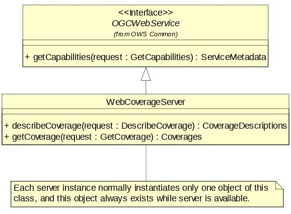
operations. (This capitalization of names uses the OGC/ISO profile of UML.) A more complete UML model of the WCS interface is provided in Annex D (informative).
OGCWebService
+ getCapabilities(request : GetCapabilities) : ServiceMetadata
(from OWS Common)
<<Interface>>
Each server instance normally instantiates only one object of this class, and this object always exists while server is available.
WebCoverageServer
+ describeCoverage(request : DescribeCoverage) : CoverageDescriptions + getCoverage(request : GetCoverage) : Coverages
Figure 1 — WCS interface UML class diagram
NOTE In this UML diagram, the request and response for each operation is shown as a single parameter that is a data structure containing multiple lower-level parameters, which are discussed in subsequent clauses. The UML classes modeling these data structures are included in the complete UML model in Annex D.
Each of the three operations is described in more detail in subsequent clauses.
7 Shared aspects
7.1 Introduction
This clause specifies aspects of the WCS behavior that are independent of particular operations or are shared by several operations.
7.1.1 WCS XML MIME Type: application/x-wcs+xml
Historically, when XML (valid against the WCS XML Schemas) was used by WCS clients and servers, the MIME type “text/xml” or “application/xml” was used as the Content-Type in HTTP requests and responses.
Herein, all WCS operation requests and responses containing XML valid against this WCS specifications XML Schemas shall use the MIME type “application/x-wcs+xml” or
“application/wcs+xml” (when it is finally registered with IANA). This new MIME type complies with RFC 3023, Appendix A.
7.2 Operation request encoding
7.3 XML Schema notes
The data type of many parameters is specified as “Character String type, not empty”. In the XML Schemas specified, these parameters are encoded with the xsd:string type, which does NOT require that these strings not be empty.
7.4 Operation response encoding and reserved characters
All operation responses shall comply with the XML syntax. In addition, several parameter values provided in CoverageSummary and CoverageDescription operation responses shall be usable literally (“as-is”) in subsequent DescribeCoverage and GetCoverage operation requests to the specific server, encoded in KVP or XML. Therefore, in stating values for these
parameters, servers shall avoid, encode, or escape any “special” characters that could be interpreted as part of either the XML markup (‘<’ ‘>’ ‘--’ ‘&’ etc.) or the KVP syntax (‘?’ ‘=’ ‘&’ etc.) of subsequent requests.
In particular, to support XML requests, operation responses shall avoid special characters, or encode or escape them using character or numeric entities (e.g., “>” or “>”in lieu of “>”) as defined in XML [W3C 2004]. To support KVP requests, operation responses shall avoid special characters, or URL-encode them (e.g., “%3F” for “?”) as defined in [RFC 2396].
7.5 CRS definitions and references
WCS use of CRSs
WCS operation requests and responses frequently include references to a defined Coordinate Reference System (CRS), and sometimes include a CRS definition. A defined CRS is required for spatial referencing by coordinates, and is a coordinate system which is related to an object by a datum. This specification makes use of material in several other OGC documents that specify how to define and reference CRSs.
In many cases, WCS operation requests and responses transfer only references to defined CRSs, not the actual CRS definitions. Each referenced CRS shall be defined somewhere, but that definition may not be electronically accessible or encoded in XML. Nonetheless, the referenced definitions often need to be used by WCS server software.
CRS definitions
OGC Abstract Specification Topic 2 “Geographic information — Spatial referencing by coordinates” [OGC 05-103], which contains ISO/DIS 19111, specifies how to define many types of CRSs, including the Datums and Coordinate Systems that define a CRS. Clause 7 of that document specifies the following types of CRSs, all of which might be used with a WCS grid coverage:
a) GeodeticCRS (formerly GeographicCRS and GeocenticCRS) b) ProjectedCRS
g) EngineeringCRS
Clause 12 of GML 3.1.1 [OGC 03-105r1] specifies how to XML encode the definitions of all these types of CRSs, based on an older version of OGC Abstract Specification Topic 2 [OGC 04-046r3]. Three GML 3.1.1 profiles extract the parts of GML 3.1.1 that appear useful to a WCS, namely:
a) OGC 05-094r1, GML 3.1.1 CRS support profile, which is used by the following two profiles
b) OGC 05-095r1, GML 3.1.1 common CRSs profile, which covers GeographicCRS, ProjectedCRS, VerticalCRS, and CompoundCRS definitions
c) OGC 05-096r1, GML 3.1.1 grid CRSs profile, which covers ImageCRS and DerivedCRS definitions
Annex F in this document specifies how to XML encode a GridCRS definition, in a simplified manner that is loosely based on a DerivedCRS.
CRS references
Clause 10.3 of OWS Common [OGC 06-121r3] specifies how CRSs shall be referenced. A URL can be used to reference a definition that is available using this URL. When not in the same XML document, those definitions shall be electronically available using this URL. Alternately, a URN in the “ogc” URN namespace can be used, and often should be used, to reference a CRS definition identified in that “ogc” URN namespace.
The format of URNs in the “ogc” namespace is recommended in Clause 7 of OGC Best Practices Paper [OGC 06-023r1], “Definition identifier URNs in OGC namespace”. Some recommended URN formats include parameter values that allow that URN to be used for an entire family of CRSs (such as different origins).
Numerous specific URN values for CRSs and components are currently specified in:
a) Clause 8 and Annex A of [OGC 06-023r1], “Definition identifier URNs in OGC namespace”, for numerous CRSs and components
b) Clause 10 of OGC 05-096r1, GML 3.1.1 grid CRSs profile, for ImageCRSs, DerivedCRSs, and components (including URNs for most possible 2D ImageCRSs)
c) Subclause F.3 in this document, for three specific OperationMethods (expected to be referenced by most 2D GridCRS definitions)
7.5.1 ImageCRSs used in WCS
NOTE 1 An ImageCRS is defined in OGC Abstract Specification Topic 2, which includes a copy of ISO 19111. That ImageCRS is specialized in the GML 3.1.1 grid CRSs profile. Such an ImageCRS has only spatial coordinate axes. A CRS for an image with both spatial and temporal axes can be defined as a CompoundCRS, as defined in OGC Abstract Specification Topic 2. However, no examples of this are now included in this document.
WCS 1.1 uses only ImageCRSs with the origin at the centre of the first recorded pixel, to be consistent with ISO 19123. Negative coordinate values shall not be used, since they would reference pixels that do not exist. Therefore, the ImageCRS identifier should be changed when the origin pixel is changed, from the origin of an offered coverage to the origin of an output coverage that is derived from that offered coverage.
NOTE 2 One possible way to generate a different ImageCRS Identifier for an output image that has a different origin than the offered coverage would be to extend the ImageCRS Identifier of the offered coverage. This extension could encode the position of the output image’s origin pixel, relative to the offered image’s origin pixel. This relative origin identifier could contain one (positive) integer for each dimension of the ImageCRS. For example, if the offered coverage's ImageCRS is
"urn:ogc:def:crs:OGC:0.0:ImageCRSpixelCenter:ABC123", the output coverage's ImageCRS might be "urn:ogc:def:crs:OGC:0.0:ImageCRSpixelCenter:ABC123DE:987:654”.
When such an ImageCRS is referenced, the first recorded pixel shall be the first pixel in this ImageCRS. For a spatial 2D image, the first recorded pixel has the indices 0,0. For a spatial 3D image, the first recorded pixel has the indices 0,0,0. For a spatial 1D image, the first recorded pixel has the index 0.
In WCS 1.1, all 2D ImageCRSs should be referenced using the URN form specified in Subclause 10.2 of [OGC 05-096r1], namely
“urn:ogc:def:crs:OGC:0.0:ImageCRSpixelCenter:TBD”. Each specific ImageCRS shall be for the image, or image group, whose alphanumeric character string identifier is
substituted for the “TBD” in this URN. When these URNs are used, there is no need to provide a definition for each specific ImageCRS, since the definition of this ImageCRS is completely specified in Clause 10 of [OGC 05-096r1], with the exception of the image identifier that is directly included in this URN.
7.5.2 GridCRSs used in WCS
WCS 1.1 uses the GridCRSs specified in Annex F of this document. Each coordinate value in a GridCRS is the index of a spatial position in the grid coverage, with units of Grid Spacings (like an ImageCRS). (Coordinate values in a GridCRS are NOT in the referenced GridBaseCRS.) To refer to a recorded pixel, each coordinate value will be an integer. However, to refer to a general position in a grid coverage, each coordinate value may include a fractional value to reference positions between recorded pixels.
The origin of a GridCRS may be at either of the following alternatives:
a) The origin may be the first pixel recorded for that grid coverage (similar to an ImageCRS). In this case, negative coordinate values shall not be used, since they would reference pixels that do not exist. Also, the GridCRS definition identifier should be changed when its first pixel is changed, from the origin of an offered coverage to the origin of an output coverage that is derived from that offered coverage. Specifically, the GridOrigin value(s) should be changed.
are defined, but may not be recorded in the grid coverage. In this case, the GridCRS origin pixel (with 0 valued indices) may be anywhere in the pixels recorded, or may be anywhere outside the pixels recorded, and thus not recorded. In both cases, the same GridCRS definition may be used for grid coverages recorded with different first pixels, from the same or different original coverages or images. Also, the GridCRS definition identifier should be changed when any other part of the GridCRS definition is changed, either the GridOrigin, GridOffsets, or GridBaseCRS.
In WCS 1.1, the definition of each referenced GridCRS is always included in the same operation request or response. This is done since many GridCRSs will be unique. No URN form for referencing GridCRSs is currently specified, but probably should be defined. Such a GridCRS may then be referenced as a SupportedCRS or in a BoundingBox, included in an operation request or response.
7.5.3 WCS use of GridCRSs
In WCS 1.1, a georectified image or coverage always uses a GridCRS, for both offered and output coverages. Each GridCRS specifies the origin and offsets between recorded coverage pixels, in the referenced GridBaseCRS. For a georectified image or coverage, the referenced GridBaseCRS shall be a ground space CRS, which may be a
GeographicCRS, ProjectedCRS, VerticalCRS, or CompoundCRS that combines a VerticalCRS with a 2D GeographicCRS or ProjectedCRS.
NOTE 1 An ImageCRS is not used for a georectified image because a GridCRS provides more useful information. Specifically, that GridCRS specifies the location of the grid points in the referenced GridBaseCRS, and that information is often needed to usefully exploit this coverage. If used, an ImageCRS would provide only the identification of the image, allowing finding the image pixels. However, an ImageCRS requires that the origin be the first pixel recorded. Furthermore, an ImageCRS should only be used for an image, not for a more general grid coverage.
In WCS 1.1, an unrectified image may use either an ImageCRS or a GridCRS with its GridBaseCRS being an ImageCRS, for both offered and output coverages. Such a
GridCRS may be used when an unrectified image was previously processed, to change the pixel spacing or origin. That GridCRS specifies the origin and offsets between the
recorded coverage pixels, each in the referenced original ImageCRS before the known previous processing. If such previous processing is not known, an ImageCRS for the current image is used.
NOTE 2 A separate ImageCRS is not used for an unrectified image when a GridCRS is known and used, because that GridCRS allows providing more useful information. Also using an ImageCRS separate from the GridBaseCRS of that GridCRS would not provide needed additional information. The only information in a WCS 1.1 ImageCRS is the identification of the image, allowing finding the image pixels. For an offered coverage, that image identification is not needed separate from the Identifier in the CoverageDescription. For an output coverage, that image identification should be assigned by the WCS client.
In WCS 1.1, no GridCRS should be used whose GridBaseCRS is another GridCRS, for either a georectified or unrectified image.This limitation is partially because WCS 1.1 provides no place to transfer the definition of a GridCRS that is used as the GridBaseCRS of another GridCRS which is for an offered image. A URL to a location where the
GridCRS definition is stored might be used, except for difficulties in implementing such URL access.
7.5.4 Current WCS uses of CRSs
WCS 1.1 operationrequests and responses frequently include references to a defined Coordinate Reference System (CRS), and sometimes include a CRS definition. Table 1 summarizes these CRS uses in this version of this OGC Standard. In Table 1:
a) In the left column, all the WCS 1.1 data structures and parameters that define or reference CRSs are listed in Bold. All of these are CRS references (with type URI) except for GridCRS (three times), which are GridCRS definitions.
b) In the left column, indented lists are used to identify which larger data structures and operation request or response contains each listed CRS reference or definition. The multiplicity of most data structures and parameters is indicated using UML notation. c) In the other three columns, the allowed types of CRSs are listed for each CRS reference or definition, for each of three conditions based on the nature of the offered coverage. These conditions map to the use cases described in Annex G and listed in the table header.
d) In the second column, the allowed types of CRSs are listed for a (previously) georectified offered coverage.
e) In the third column, the allowed types of CRSs are listed for an unrectified offered coverage that is not (known by the WCS server to be) georeferenced. This column also applies if the unrectified offered coverage is georeferenced, but the WCS server is not requested to apply, or cannot apply, the (known) georeferencing coordnate transformation. f) In the right column, the allowed types of CRSs are listed for an unrectified offered coverage that is georeferenced when the georeferencing coordinate transformation IS used by the GetCoverage operation to georectify that image. If the unrectified coverage is georeferenced but the georeferencing coordinate transformation is NOT used by the GetCoverage operation to georectify that image, then the third column applies except for including the georeferencing coordinate transformation with the output coverage.
Table 1 — WCS uses of CRSs
Operation (direction) Data structure name
Data structure name
Allowed types of CRS, for offered coverages that are: Georectified
CoverageDescription CRS of offered coverage a See SupportedCRS in CoverageDescription
Output [1]
offered coverage offered coverage a
GridBaseCRS [1] See SupportedCRS in
CoverageDescription ImageCRS of offered or original coverage See SupportedCRS in CoverageDescription GetCoverage (response)
Coverage N/A N/A N/A
BoundingBox [1]
crs [1] Reference to GridCRS below GridCRS or ImageCRS of output coverage
Reference to GridCRS below
GridCRS [0..1] (definition) GridCRS of output
coverage GridCRS of output coverage, when used GridCRS of output coverage
GridBaseCRS [1] See SupportedCRS in
CoverageDescription ImageCRS of offered coverage See SupportedCRS in CoverageDescription DescribeCoverage (response)
GridCRS [0..1] (definition) GridCRS of offered
coverage GridCRS of offered coverage, if used GridCRS of offered coverage, if used
GridBaseCRS [1] See SupportedCRS in
CoverageDescription ImageCRS ImageCRS
ImageCRS [0..1] (none) ImageCRS of offered
coverage, if used ImageCRS of offered coverage, if used GetCapabilities (response)
SupportedCRS [0..*] See SupportedCRS in CoverageDescription
a The CRS of an unrectified offered coverage may be an ImageCRS or a GridCRS with a GridBaseCRS that is an ImageCRS. b In addition to a GeographicCRS or ProjectedCRS, other ground space CRSs may be referenced, including a VerticalCRS or a CompoundCRS that combines a VerticalCRS with a 2D GeographicCRS or ProjectedCRS. These CRS types are sometimes referred to as ground CRSs.
c An ImageCRS for an unrectified offered image shall be listed as a SupportedCRS, so that it may be referenced as the GridBaseCRS of a GridCRS. This ImageCRS shall be the ImageCRS of that unrectified offered image, or the ImageCRS that is referenced as the GridBaseCRS of the GridCRS that is used by that unrectified offered image.
d Followed by zero or more of any SupportedCRS listed in the CoverageDescription.
7.6 BoundingBox use in WCS
General terms
This specification uses the BoundingBox and WGS84BoundingBox data structures, specified in Subclause 10.2 of OWS Common [OGC 06-121r3], to express the minimum rectangular bounding region around (available or requested) coverage data. In a Bounding Box data structure, the LowerCorner defines the edges of the (available or requested) region in the directions of decreasing coordinate values in a CRS (normally the algebraic minimum
coverages, these values shall be computed from the areas of all the (available or requested) coverage grid cells with all corners at recorded grid points.
NOTE 1 Inclusion of the areas of all grid cells is not necessarily the same as inclusion of all the grid points, when the grid coverage spans the antimeridian as discussed below.
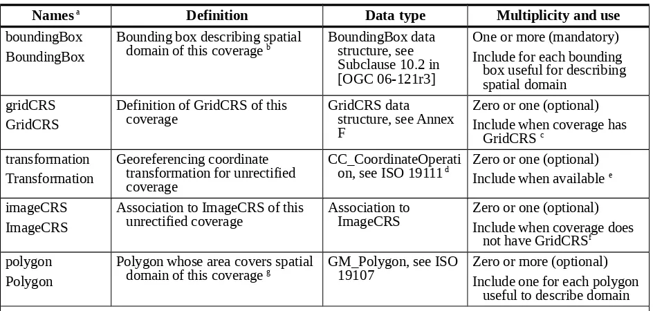
In keeping with ISO 19123, WCS considers only grids whose points lie at the corners (not the centres) of the grid cells. This document thus primarily considers “continuous” grid coverages, not “discrete” grid coverages, as those terms are defined in ISO 19123. As illustrated in Figure 2 below, grid points (a, b, c, d) define a grid cell (U) and are surrounded by "sample spaces" (A, B, C, D) as those terms are used in Subclause 8.2.2 of ISO 19123.
Figure 2 — Grid points, grid cells, and sample spaces
NOTE 2 For these sample spaces, this document avoids using terms such as “sample grid” or “pixels”, although such terms are often used elsewhere.
The following subclauses clarify the use of such a bounding box near discontinuities in a geographic CRS, and the handling of grid points at the edges of the coverage.
Spanning the antimeridian of a geographic CRS
In a geographic CRS, longitude values are often defined with a finite extent (e.g., from -180 degrees to +180 degrees). The minimum and maximum longitude limits define a single line (on the ellipsoid, sphere, or cylinder), known as the antimeridian, across which longitude values are discontinuous: as this line is crossed, longitude changes abruptly (e.g., going West from a little more than -180 degrees to a little less than +180 degrees). This necessitates an “extended” interpretation of the Bounding Box definition:
A Bounding Box defined in a geographic CRS (or a WGS84BoundingBox) whose LowerCorner longitude is greater than that of its UpperCorner shall describe a region that crosses the longitude discontinuity.
EXAMPLE A bounding region encompassing the Pacific Ocean could be described by a BoundingBox with a positive LowerCorner longitude and a negative UpperCorner longitude.
![Table 23 of [OGC 06-121r3]](https://thumb-ap.123doks.com/thumbv2/123dok/3714054.1812334/41.612.72.537.117.489/table-of-ogc-r.webp)