INTER COMPARISON OF ATMOSPHERIC CORRECTION MODELS - SACRS2,
FLAASH AND 6SV USING RESOURCESAT-2 AWIFS DATA
Vishal. N. Pathak a,b, *, M. R. Pandya c, D. B. Shah b, H. J. Trivedi b , K. D. Patel a , V. N. Sridhar c and R. P. Singh c
a
Department of Physics, Sardar Patel University, Vallabh Vidyanagar - 388120, Gujarat, India ([email protected], [email protected])
b
N. V. Patel College of Pure and Applied Sciences, Vallabh Vidyanagar - 388120, Gujarat, India([email protected], [email protected])
c
Space Applications Centre, Ahmadabad -380015, Gujarat, India (mrpandya, rpsingh,[email protected])
KEY WORDS: Atmosphere, Correction, IRS, Land, Spectral.
ABSTRACT:
Remote sensing measurements from space born sensors are strongly attenuated by the scattering and absorption processes through atmospheric molecules, aerosols and gases (ozone, water vapour, oxygen etc). The process of removing the atmospheric interference from the satellite-level signal is called atmospheric correction. Atmospheric correction can be performed through various methods such as, empirical method, semi-physical method, detailed radiative transfer models. Various methods exist for atmospheric correction of available global sensors such as NOAA-AVHRR, MODIS-Terra/Aqua, MERIS, Landsat-TM/ETM etc. However, there was no method available for atmospheric correction of the IRS data sets. A new physics-based model called Scheme for Atmospheric Correction of ResourceSat-2 AWiFS data (SACRS2) has been developed at Space Applications Centre (SAC) specifically tuned for the RS2-AWiFS sensor. This model has been developed from theoretical signal simulations using the 6SV (The Second Simulation of the Satellite Signal in the Solar Spectrum vector version) code. A detail analysis was carried out to perform inter comparison of the results of SACRS2 model with standard atmospheric correction models such as FLAASH (Fast Line-of-sight Atmospheric Analysis of Spectral Hypercube) and 6SV on RS2-AWiFS data. In turn, the performance of all three models was compared to in-situ measurements carried out over an experimental site located in the Kutch desert for seven RS2-AWiFS overpasses. The results showed a fairly good match of reflectance derived by all three correction models with the in-situ measurements.
1. INTRODUCTION
Sensors onboard satellites receive the coupled response of the earth's surface and atmosphere within the designated spectral bands. The signal received at the satellite -based sensor in the visible - near infrared spectral region is attenuated by the atmospheric gases and aerosol through absorption and scattering processes. This attenuation can affect the intensity and spectral composition of the radiation (Lillesand et al 1999). The signals received at the satellite are an integrated spectral response of the target within the designed spectral width of the sensor this signal is provided to the user in form of digital number (DN). In raw unprocessed image DN value do not quantitatively correspond to the physical units such as radiance, reflectance or temperature. Thus remote sensing studies which intend to utilize satellite data for estimation of quantitative spectral surface characteristics need to be converted the DN to target reflectance (Pandya et al.2002) which has to be compensated by an appropriate procedure to obtain accurate reflectance of the surface. The procedure for removing the atmospheric effects from the satellite-measured signal to retrieve the surface reflectance is called atmospheric correction.
The Indian Remote Sensing (IRS) satellite series has been providing data since 1988 through various missions such as, IRS-1A, 1B, 1C, 1D, P2, P3, P4, P5, P6 or Resourcesat-1 (RS1), Oceansat - 2 and Resourcesat - 2 (RS2) (Pandya et al.2013) for various terrestrial applications. The Advanced Wide Field Sensor (AWiFS) is one of the three payloads onboard Resorucesat-2 (RS2) satellite having four spectral channels in green (520-590 nm), red (620-680 nm), near-infrared (NIR) (770-860nm) and shortwave near-infrared (SWIR) (1550-1700 nm) spectral regions with a nominal spatial resolution of 56 meter. There are many empirical and physics
based models available in the literature for atmospheric correction like a LOWTRAN (Kneizys et al.,1988), MODTRAN (Berk et al., 1989), 5S (Tanre et al., 1990), 6S (Vermote et al., 1997b), SBDART (Ricchiazzi et al., 1998), SMAC (Rahman et al.1994) and 6SV (Vermote et al., 2006) available in the literature. Amongst these models Second Simulation of Satellite Signal in the Solar Spectrum Vector version (6SV) widely used and well documented for atmospheric correction in VIS and NIR region. Many of these models can correct the atmospheric effects for sensors such as AVHRR, ASTER, MODIS, SPOT, Landsat etc. However, there is no method available for atmospheric correction of RS2 sensors. Recently a new physics based model has been developed namely, SACRS2 (Scheme for Atmospheric Correction of ResourceSat-2) Pandya et al.(2014a,2014b) for RS2-AWiFS data. This paper reports the results of a study that was carried out to compare various atmospheric correction models for the RS2 -AWiFS data.
2. ATMOSPHERIC CORRECTION MODELS
Several atmospheric correction models are available for correcting atmospheric attenuations incorporated in satellite observations, such as FLAASH, 6SV, QUAAC, ATCOR etc. In this paper we did a comparative assessment of three atmospheric correction models namely 6SV, FLAASH and a newly developed SACRS2 with in-situ measurements.
I) SACRS2: In SACRS2 model raw data (digital number) of RS2-AWiFS and inputs related to atmospheric parameters and viewing geometry to obtain the atmospherically corrected surface reflectance. The SACRS2 requires two sets of inputs, 1) An input text file containing information of atmosphere and viewing geometry.2) Raw RS2-AWiFS image (digital numbers)
The International Archives of the Photogrammetry, Remote Sensing and Spatial Information Sciences, Volume XL-8, 2014 ISPRS Technical Commission VIII Symposium, 09 – 12 December 2014, Hyderabad, India
This contribution has been peer-reviewed.
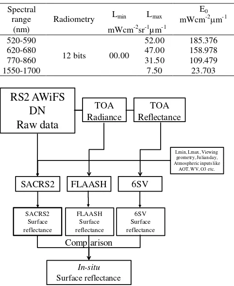
with 4 spectral bands. In the text file number of lines and pixels of images Lmin and Lmax for all the corresponding bands (table 2),day of the year, sun zenith and azimuth, view zenith and azimuth, altitude, AOT, WV, O3 and option for atmospheric correction variable type 1; atmospheric correction ON / 0: No atmospheric correction. If atmospheric correction is not performed then the code will only generate the TOA reflectance image and if give as input 1 then generates both TOA and Surface reflectance images.
II) FLAASH: FLAASH is a model in built available with ENVI input software for atmospheric correction of the multispectral and hyper spectral data in the visible-near infrared and shortwave infrared range (up to 3000nm). It incorporates the MODTRAN 4 radiation transfer code and needs a number of input parameters such as scene centre, sensor type and altitude, Satellite overpass time, ground elevation, pixel size etc. These parameters can be typically obtained from the metadata file of the satellite data. In FLAASH radiance image is used input So we have to convert the digital number in to the TOA radiance using equation (1) and radiance image all converted into BIL format. FLAASH accepts the input parameters through a GUI and saves them as a template file. RS2 has a sensor altitude of 817 km. The central wavelength location and gain of each of the spectral bands were obtained from the header files of the image data. The average ground elevation for the in-situ is taken as 100 meter above the sea level.
III) 6SV: The 6SV code was available to be downloaded free of charge. It is an improved version of the 5S code, which is able to simulate the signal observed by a satellite sensor for a lambertian target at sea level altitude, in the solar spectrum wavelength (250-4000nm).The model can run by executing a command batch file (a.bat file). To run the model the input files must be in the same directory as the executable file. The output files will also be written in the same directory. The following inputs are necessary: 1) Geometrical condition 2) Atmospheric model for the gaseous vertical profiles, and the water vapour and ozone column content if the model default value have to be overwritten. The present study of US standard 1962 profiles used in 6SV code. We have given input as TOA and pixel based correction in 6SV code and so we have used 3 × 3 pixel average value of the surface reflectance.
3. DATA USED AND METHODOLOGY
The RS2-AWiFS datasets used in the analysis correspond to six months duration from November 2013 to April 2014 shown in table.1. The satellite pass (091/053) covers the region of Gujarat and surrounding. The details of satellite data used for atmospheric correction is shown in table 2. Field experiments were carried out for measuring atmospheric and surface characteristics over Rann of Kutch area of Gujarat (fig.2). The site provides a stable land cover in terms of surface reflectance. This presents an excellent testing ground for satellite derived reflectance (Sridhar et al.2013). The atmospheric characteristics such as aerosol optical thickness at 550nm, columnar water vapour content, total ozone content were measured by Mircortops-II Sunphotometer. The surface spectral reflectance was on each of seven days matching to the satellite overpass measured using the hand held ASD Spectroradiometer. The 6SV required the TOA reflectance as an input while FLAASH needs TOA radiance as an input. So digital number (DN) values were converted to spectral radiance and then into TOA reflectance using the formulae given below
Table 1. Satellite data use for atmospheric correction
Date of
acquisition Satellite Sensor Path/Row GSD 25 Nov 2013
Here Lmax and Lmin are the minimum and the maximum detected spectral radiance for the sensor values are shown in table 2. Table.2 Details of satellite data used for atmospheric corrections
Figure1: Flow chart Showing the Atmospheric correction of AWiFS data using SACRS2, FLAASH and 6SV models The steps followed in this study for the atmospheric correction of RS2 AWiFS data and are comparison of three atmospheric correction models presented in figure 1. Model derived surface reflectance have been compared using in-situ measurements of ASD Spectroradiometer. Atmospheric inputs like
AOT, WV, O3 etc.
Radiometry Lmin Lmax
E0
The International Archives of the Photogrammetry, Remote Sensing and Spatial Information Sciences, Volume XL-8, 2014 ISPRS Technical Commission VIII Symposium, 09 – 12 December 2014, Hyderabad, India
This contribution has been peer-reviewed.
4. RESULTS AND DISCUSSION
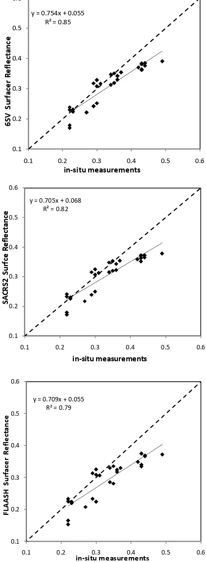
Fig.2 Shows validation site in the Runn of Kutch. The performance of all three atmospheric correction models (SACRS2, FLAASH and 6SV) was evaluated in terms of relative deviation (RD) of model derived surface reflectance with respect to in-situ measurement. Fig.3 shows comparative results of the surface reflectance computed using all three atmospheric correction models with in – situ measurements for all the seven passes of RS2 AWiFS sensor. Graphs show that all three models compute the surface reflectance reasonably well with high R2 value ranging from 0.79 to 0.85. Co-efficient of determination (R2) is highest (0.85) for 6SV RT model. The relative deviation in the model derived reflectance with respect to the in-situ reflectance varied by 0.5% to 9.68% for SACRS2, 0.3% to 9.93% for 6SV and 0.05% to 10.0% for FLAASH. This study has clearly demonstrated that the newly developed SACRS2 models has similar capability of correcting atmosphere effects almost similar to that 6SV and better than FLAASH. Moreover, SACRS2 has advantage of correcting full RS2-AWiFS image (∼15000 pixels × 15000 pixels) , which is not possible with the 6SV (which performs detail calculations on by point basis) or FLAASH (which fails on full AWiFS image) models. We observed that the SWIR band of RS-2 AWiFS consistently shows high RD % for all three models as compared with in-situ measurements.
Figure 2.RS2 AWiFS images acquired over the Kutch validation site on 01 Mar 2014.
Table.3 Atmospheric parameters measurements by Sunphotometer for study sites
Site Date Figure 3. Comparison of Surface reflectance with in-situ
measurements CONCLUSION
In this paper, we have reported the results of a comparative study carried out on RS2-AWiFS data to check the performance of three atmospheric correction models with respect to in-situ measurements. The 6SV RT model has been found most suitable for the atmospheric correction of RS-2 AWiFS data with highest coefficient of determination (0.85) followed by
y = 0.754x + 0.055
The International Archives of the Photogrammetry, Remote Sensing and Spatial Information Sciences, Volume XL-8, 2014 ISPRS Technical Commission VIII Symposium, 09 – 12 December 2014, Hyderabad, India
This contribution has been peer-reviewed.
SACRS2 and FLAASH having coefficient of determination 0.82 and 0.79 respectively. However, the biggest advantage of SACRS2 model over 6SV or FLAASH is that SACRS2 can be used for correcting full RS2-AWiFS datasets, which other two models can not correct such datasets. Thus, it can be concluded that SACRS2 model tuned specifically for RS2-AWiFS Sensor can be used for correcting the RS2-AWiFS datasets.
ACKNOWLEDGEMENTS
This work has been carried out in a collaborative study under SAC R&D project "Development of a scheme for atmospheric correction of RS2 AWiFS data. We thank Shri A. S. Kirankumar, Director, SAC, Dr. P. K. Pal, Deputy Director, EPSA, Dr. B Bakshi, Principal, NVPAS and Dr. U. H. Patel Head of the Department of Physics S.P. University for their guidance and support to the study.
REFERENCES
Berk A., Bernstein L.S. and Robertson D.C. 1989 MODTRAN: A Moderate Resolution Model for LOWTRAN 7. GL-TR-89-0122. Phillips Lab, Hanscom Air Force Base, Mass.
Kneizys F.X., Shettle E.P., Abreu L.W., Chetwynd J.H., Anderson G.P., Gallery W.O., Selby J.E.A., and Clough S. A., 1988 User;s guide to LOWTRAN 7, Air Force Geophysics Laboratory, Hanscom AFB Environmental Research Report ERP, No.1010.
Lillesand, T.M. and Kiefer, R.W.,1999. Remote Sensing and Image Interpretation. John Wiley & Sons, Inc, 9-10, pp 592-597.
Pandya M. R., Singh R.P., Murli K.R., Babu N., Kirankumar A. S., and Dadhwal V.K.(2002). Bandpass solar exoatmospheric irradiance and Rayleigh optical thickness of sensors on board Indian Remote Sensing Satellites-1B, 1C, 1D & P4. IEEE Trans. Geosci. Remote Sensing, 40: pp 714-718.
Pandya M.R., Murli K.R. and Kirankumar A. S. (2013). Quantification and comparison of spectral charcteristics of sensors on board Resourcesat-1 and Resorcesat-2 satellites, Remote Sensing Letters, 4, pp 306-314.
Pandya M.R., Pathak V.N., Shah D.B., Trivedi H.J., Chipade R.A., Singh R.P., Kirnakumar A.S., (2014a) Devlopment of a Scheme for Atmospheric Correction of Resourcesat-2 AWiFS data submitted in International Journal of Applied Earth Observation and Geoinformation.
Pandya M.R., Pathak V.N., Shah D.B., Singh R.P.,(2014b) Retrieval of surface reflectance using SACRS2: A Scheme for atmospheric correction of Resourcesat-2 AWiFS data submitted in ISPRS symposium by TC-8, Hydrebad, Dec 9-12,2014. Rahman H., and Dedieu G., 1994. SMAC: A simplified method for atmospheric correctio of satellite measurements in the solar spectrum, International Journal of Remote Sensing,15, pp 123-143.
Ricchiazzi P., Yang S., Gautier C., and Sowle D., 1998. SBDART: A Research and Teaching Software Tools for Plane -parallel Radiative Transfer in the Earth's Atmosphere, Bulletin of the American Meterological Society, 79(10). pp.2101-2114.
Sridhar V. N., Mehta K. B., Prajapati R. P., Babu K. N., Suthar N. M., and Shukla A. K. (2013). Absolute vicarious callibration of OCM2 and AWiFS sensors using a reflectance-based method over land sites in the Rann of Kutch, Gujarat. Int. J. Rem.Sens. 34(6):5690-5708.
Tanre D., Deroo C., Dahaut P., Herman M. and Morcrette J.J., 1990. Description of a computer code to simulate the satellite signal in the solar spectrum: the 5S code, International Journal of Remote Sensing. 11, pp 659-688.
Vermote E.F., Tanre D., Deuze, Herman M. and Morcette J., 1997b. Second simulation of the satellite signal in the Solar Spectrum, 6S: An Overview.IEEE Transcations on Geoscience and Remote Sensing, 35 pp. 675-686.
Vermote E.F., and Saleous N.Z., Operational atmospheric correction of MODIS visible to middle infrared land surface data in the case of an infinite lambertian target, 2006,In: Earth Science Satellite Remote Sensing, Science and Instruments,(eds:Qu.J.et.al),1,pp. 123-153.
The International Archives of the Photogrammetry, Remote Sensing and Spatial Information Sciences, Volume XL-8, 2014 ISPRS Technical Commission VIII Symposium, 09 – 12 December 2014, Hyderabad, India
This contribution has been peer-reviewed.