Open Geospatial Consortium
Approval Date: 2012-06-22
Publication Date: 2012-07-12
External identifier of this OGC® document: http://www.opengis.net/doc/DP/waterml-timeseries-netcdf
Reference number of this OGC® project document: OGC 12-031r2
Category: OGC® Discussion Paper
Editor: Doug Palmer
WaterML 2.0
– Timeseries – NetCDF Discussion PaperCopyright © 2012 Open Geospatial Consortium.
To obtain additional rights of use, visit http://www.opengeospatial.org/legal/.
Warning
This document is not an OGC Standard. This document is an OGC Discussion Paper and is therefore not an official position of the OGC membership. It is
distributed for review and comment. It is subject to change without notice and may not be referred to as an OGC Standard. Further, an OGC Discussion Paper should not be referenced as required or mandatory technology in procurements.
License Agreement
Permission is hereby granted by the Open Geospatial Consortium, ("Licensor"), free of charge and subject to the terms set forth below, to any person obtaining a copy of this Intellectual Property and any associated documentation, to deal in the Intellectual Property without restriction (except as set forth below), including without limitation the rights to implement, use, copy, modify, merge, publish, distribute, and/or sublicense copies of the Intellectual Property, and to permit persons to whom the Intellectual Property is furnished to do so, provided that all copyright notices on the intellectual property are retained intact and that each person to whom the Intellectual Property is furnished agrees to the terms of this Agreement.
If you modify the Intellectual Property, all copies of the modified Intellectual Property must include, in addition to the above copyright notice, a notice that the Intellectual Property includes modifications that have not been approved or adopted by LICENSOR. THIS LICENSE IS A COPYRIGHT LICENSE ONLY, AND DOES NOT CONVEY ANY RIGHTS UNDER ANY PATENTS THAT MAY BE IN FORCE ANYWHERE IN THE WORLD.
THE INTELLECTUAL PROPERTY IS PROVIDED "AS IS", WITHOUT WARRANTY OF ANY KIND, EXPRESS OR IMPLIED, INCLUDING BUT NOT LIMITED TO THE WARRANTIES OF MERCHANTABILITY, FITNESS FOR A PARTICULAR PURPOSE, AND NONINFRINGEMENT OF THIRD PARTY RIGHTS. THE COPYRIGHT HOLDER OR HOLDERS INCLUDED IN THIS NOTICE DO NOT WARRANT THAT THE FUNCTIONS CONTAINED IN THE INTELLECTUAL PROPERTY WILL MEET YOUR REQUIREMENTS OR THAT THE OPERATION OF THE INTELLECTUAL PROPERTY WILL BE
UNINTERRUPTED OR ERROR FREE. ANY USE OF THE INTELLECTUAL PROPERTY SHALL BE MADE ENTIRELY AT THE USER’S OWN RISK. IN NO EVENT SHALL THE COPYRIGHT HOLDER OR ANY CONTRIBUTOR OF
INTELLECTUAL PROPERTY RIGHTS TO THE INTELLECTUAL PROPERTY BE LIABLE FOR ANY CLAIM, OR ANY DIRECT, SPECIAL, INDIRECT OR CONSEQUENTIAL DAMAGES, OR ANY DAMAGES WHATSOEVER RESULTING FROM ANY ALLEGED INFRINGEMENT OR ANY LOSS OF USE, DATA OR PROFITS, WHETHER IN AN ACTION OF CONTRACT, NEGLIGENCE OR UNDER ANY OTHER LEGAL THEORY, ARISING OUT OF OR IN CONNECTION WITH THE IMPLEMENTATION, USE, COMMERCIALIZATION OR PERFORMANCE OF THIS INTELLECTUAL PROPERTY. This license is effective until terminated. You may terminate it at any time by destroying the Intellectual Property together with all copies in any form. The license will also terminate if you fail to comply with any term or condition of this Agreement. Except as provided in the following sentence, no such termination of this license shall require the termination of any third party end-user sublicense to the Intellectual Property which is in force as of the date of notice of such termination. In addition, should the Intellectual Property, or the operation of the Intellectual Property, infringe, or in LICENSOR’s sole opinion be likely to infringe, any patent, copyright, trademark or other right of a third party, you agree that LICENSOR, in its sole discretion, may terminate this license without any compensation or liability to you, your licensees or any other party. You agree upon termination of any kind to destroy or cause to be destroyed the Intellectual Property together with all copies in any form, whether held by you or by any third party. Except as contained in this notice, the name of LICENSOR or of any other holder of a copyright in all or part of the Intellectual Property shall not be used in advertising or otherwise to promote the sale, use or other dealings in this Intellectual Property without prior written authorization of LICENSOR or such copyright holder. LICENSOR is and shall at all times be the sole entity that may authorize you or any third party to use certification marks, trademarks or other special designations to indicate compliance with any LICENSOR standards or specifications.
Contents
1 Scope...1
2 Normative references ...1
3 Terms and definitions ...1
4 Conventions ...2
4.1 Symbols (and abbreviated terms) ...2
4.2 UML Notation ...3
4.2.1 Use of XPath Expressions ...4
5 Motivation ...4
6 Use Cases...5
6.1 Archival Storage...5
6.2 NetCDF as a Data Payload ...5
6.3 Presenting NetCDF Timeseries as WaterML ...6
6.4 Import Format for Tools ...6
7 Relationship to Existing Standards and Conventions ...6
7.1 WaterML 2.0 ...6
7.2 NetCDF ...8
7.3 NetCDF Attribute Convention for Dataset Discovery ...11
7.4 Climate and Forecast Conventions...11
7.5 Climate Science Modelling Language ...12
7.6 Other Timeseries Conventions...13
7.7 Choice of Conventions ...13
7.8 Relationship Between Hydrology and NetCDF Conventions ...14
8 Mapping Strategies ...15
8.1 Mapping Names, URIs and Tokens ...15
8.1.1 Standard Names ...16
8.1.2 URI Tokenization ...16
8.1.3 Use of RDF ...16
8.1.4 Dictionaries and Vocabularies ...17
8.2 General Metadata ...18
8.2.1 External Metadata ...18
8.2.2 Embedded Metadata ...19
8.2.3 Default Metadata ...19
8.3 Units ...20
8.4 Categories and Measurements ...20
8.5 Locations ...20
8.6 Coordinate Reference Systems ...21
8.9 Responsible Parties ...27
8.10 Data Structures ...27
8.11 Data Payload Conventions ...27
8.12 Reconstruction of WaterML Models from NetCDF documents ...27
9 Encoding of Timeseries...28
9.1 Data Point Metadata ...29
9.2 Simple point measurement timeseries ...31
9.3 Complex Timeseries ...36
9.3.1 Higher-Dimensional Timeseries ...37
9.3.2 Record Timeseries ...38
10 Observation and Timeseries Metadata ...38
10.1 NetCDF Attribute Conventions ...38
10.1.1 Global Attributes ...38
10.1.2 Per-Timeseries Attributes ...39
10.2 Attribute Convention for Dataset Discovery ...40
10.2.1 Global Attributes ...41
10.3 Climate and Forecast Conventions...46
10.3.1 Global Attributes ...46
10.3.2 Per-Timeseries Attributes ...46
10.4 WaterML Specific Attributes ...46
10.4.1 Global Attributes ...47
10.4.2 Timeseries Attributes...51
11 Profiles ...54
11.1 Collections ...55
11.2 Use Case Profiles ...55
i.
Abstract
This discussion paper investigates the possible uses of NetCDF as a representation of WaterML timeseries data. The work is largely based on the WaterML 2.0 standard for timeseries, the NetCDF core and extensions standards and the CF-NetCDF and ADCC conventions.
ii.
Keywords
Ogc, ogcdoc, waterml, netcdf, timeseries
iii.
Preface
This is an OGC discussion paper for review by OGC members and other interested parties. It is a working draft document and may be updated, replaced by other documents at any time. It is inappropriate to use OGC Discussion Papers as reference material or to cite them as other than “work in progress.” This is a work in progress and does not imply endorsement by the OGC membership.
This discussion paper is being developed through the joint WMO-OGC Hydrology Domain Working Group.
iv.
Submitting organizations
The following organizations submitted this Discussion Paper to the Open Geospatial Consortium Inc.
a) Commonwealth Science and Industry Research Organisation (CSIRO)
v.
Submission contact points
All questions regarding this submission should be directed to the editor or the submitters:
vi.
Revision history
Date Release Author Paragraph modified Description
2012-02-13 0.1 Doug Palmer
All Initial Draft
2012-05-25 0.1.2 Doug Palmer
6, 9 Tables correctly labelled. Clarify relationship between the WaterML 2.0 conceptual model and the XML encoding. Remove dropping indices for single stations.
vii.
Changes to the OGC
®Abstract Specification
Foreword
This work has, for the most part, been funded through a water information research and development alliance between CSIRO’s Water for a Healthy Country Flagship and the Australian Bureau of Meteorology.
Attention is drawn to the possibility that some of the elements of this document may be the subject of patent rights. Open Geospatial Consortium shall not be held responsible for identifying any or all such patent rights. However, to date, no such rights have been claimed or identified.
Introduction
The WaterML 2.0 timeseries1 standard provides a consistent conceptual model for hydrological timeseries data. The WaterML model follows the OGC approach towards modelling. Models are expressed as UML and are built by specialising existing abstract standards. The models are designed to allow rich and complex data and metadata. An XML encoding of the conceptual model, which faithfully represents the model, is part of the standard.
NetCDF is a set of APIs, libraries and self-describing machine-independent data formats, commonly used in climatology, meteorology and oceanography applications for array-oriented data. NetCDF is used as an input/output format for many GIS and scientific applications, as well as for archival storage and scientific data exchange. The NetCDF model is relatively constrained. Data is encoded in multi-dimensional arrays. Metadata attributes can be attached to the arrays, or to the dataset as a whole. A range of
conventions for encoding data and attributes has grown up around NetCDF for the purposes of consistent data exchange.
A NetCDF encoding of WaterML would facilitate the archiving, exchange, import and export of hydrological observations. The first major goal of this paper is to develop a NetCDF encoding of WaterML that correctly represents a useful profile of the WaterML model. The second major goal is to ensure that any NetCDF representation of Water ML is a useful NetCDF document in the context of normal NetCDF usage; the contents of the document can be readily comprehended and processed by existing users and software. Since the conceptual models underpinning WaterML and NetCDF are not readily compatible, the paper explores the restrictions and mapping strategies needed to permit the encoding.
WaterML 2.0 Timeseries
—
NetCDF Encoding
1 Scope
This discussion paper investigates the possible uses of NetCDF as a representation of WaterML timeseries data. The work is largely based on the WaterML 2.0 standard for timeseries, the NetCDF core and extensions standards and the CF-NetCDF and ADCC conventions. The goal is to develop a set of best practices that allows WaterML
timeseries to be represented as NetCDF documents for the purposes of archiving and import/export from applications.
2 Normative references
The following normative documents contain provisions which, through reference in this text, constitute provisions of this part of OGC 12-031. For dated references, subsequent amendments to, or revisions of, any of these publications do not apply. However, parties to agreements based on this part of OGC 12-031 are encouraged to investigate the possibility of applying the most recent editions of the normative documents indicated below. For undated references, the latest edition of the normative document referred to applies.
OGC 10-126r2 WaterML 2.0: Part 1 - Timeseries
OGC 10-090r3 NetCDF Core Encoding Standard version 1.0 OGC 10-091r3 CF-netCDF Core and Extensions Primer
OGC 10-092r3 NetCDF Binary Encoding Extension Standard: NetCDF Classic and 64-bit Offset Format
OGC 07-036 OpenGIS® Geography Markup Language (GML) Encoding Standard ISO 19156:2011 Geographic information - Observations and measurements
W3C XML Linking Language (XLink) Version 1.0 W3C XML Path Language (XPath) Version 1.0 3 Terms and definitions
3.1
Classic Model
The classic NetCDF data model (NetCDF-3). 3.2
Document
A representation of some information. For the purposes of this paper, a document may be an actual document, such as a file, or a virtual document, such as a response to a web request or a response from a database query.
3.3 Dataset
A related collection of data. 3.4
Extended Model
The extended NetCDF data model (NetCDF-4). 3.5
Hydrology
The study of the movement, distribution, and quality of water on Earth (and other planets)
3.6 Profile
1. A sampling of a property along a vertical line
2. A logical restriction, defining a subset of a schema, model or standard
4 Conventions
4.1 Symbols (and abbreviated terms)
ACDD Attribute Conventions for Dataset Discovery AP Application Profile
API Application Program Interface
COARDS Cooperative Ocean/Atmosphere Research Data Service CF Climate and Forecast Metadata Convention
GEO-IDE Global Earth Observation Integrated Data Environment ISO International Organization for Standardization
NetCDF Network Common Data Format
NOAA National Oceanic and Atmospheric Administration OGC Open Geospatial Consortium
OPeNDAP Open-source Project for a Network Data Access Protocol O&M Observations and Measurements
PMEL Pacific Marine Environmental Laboratory SOS Sensor Observation Service
THREDDS Thematic Realtime Environmental Distributed Data Services UCUM Unified Code for Units of Measure
UML Unified Modelling Language
WaterML Water Markup Language (version 2.0, unless otherwise specified) XLink XML Linking Language
XPath XML Path Language
XML eXtended Markup Language
1D One Dimensional
2D Two Dimensional
3D Three Dimensional
4.2 UML Notation
4.2.1 Use of XPath Expressions
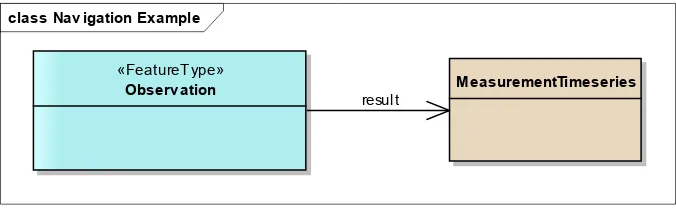
Figure 1 — Navigation Example
This document attempts to map parts of the WaterML model onto specific NetCDF variables and attributes. The WaterML model uses UML, a graphical notation. Paths through UML associations are usually expressed by including UML diagrams – see Figure 1 for an example. The number of paths described in this paper makes a graphical approach impractical. There are many cases in this document where some sort of textual notation for navigating object graphs would be useful. However, there is no generally accepted notation.
WaterML has an existing XML encoding that is auto generated from the models
following the GML encoding rules, Annex E. This encoding does not cover the entirety of WaterML, but encapsulates the intended use of the model by the hydrology
community and provides comprehensive metadata.
Rather than use a UML-based graph notation language, the WaterML instance is
considered to be expressed as its XML encoding and elements are located via the XPath language. For example, the reference shown in Figure 1 would be written as
om:OM_Observation/om:result/wml2:MeasurementTimeseries If an
abstract schema type is used, then the element name is italicised, for example
om:OM_Observation/om:result/wml2:TimeseriesType
5 Motivation
The WaterML 2.0 timeseries standard is an Observations and Measurements (O&M) application profile (AP) that captures the semantics of hydrological observational data for data exchange. WaterML has an existing XML encoding that encapsulates the intended use of WaterML in the hydrology community and is well-suited to data exchange applications.
The Network Common Data Format (NetCDF) provides a common data access method for self-describing, machine-independent datasets(Rew, et al., 2011). Array data can be compactly encoded in NetCDF documents, along with attributes that describe the meaning of the array data.
The NetCDF format is domain-independent and can be used by many branches of science and engineering. Over the years, a number of domain- and application-specific
class Nav igation Example
«FeatureType»
Observ ation MeasurementTimeseries
conventions have developed to allow consistent data representation and exchange. An influential set of conventions are the NetCDF Climate and Forecast Metadata
conventions (the CF conventions) which have developed to allow users of climate and forecast data to decide which quantities are compatible and consistently extract, sample and display data(Eaton, et al., 2011).
NetCDF is also a common format for web-based data catalogues. Suitable attribute conventions, such as the Attribute Convention for Dataset Discovery(Davis, 2005), can be used to allow dataset servers, such as THREDDS(Unidata Program Center) to make datasets searchable. Servers that support the Open-source Project for a Network Data Access Protocol (OPeNDAP) allow applications to request slices of large datasets from network repositories, with NetCDF one of the supported formats(OPeNDAP, 2009). 6 Use Cases
An instance of the WaterML model is a specific representation of timeseries data that conforms to the WaterML conceptual model. It may be an in-memory object that is part of a program or a suitably encoded document. At present, the only instances of WaterML that formally conform to the model are documents in the XML encoding, which conform to a profile of the model.
Ideally, a NetCDF encoding of WaterML should represent a relationship between the WaterML conceptual model and a NetCDF document, rather than XML encoded WaterML and NetCDF encoded WaterML. In the following use cases, a WaterML instance refers to any representation of WaterML.
6.1 Archival Storage
NetCDF provides a convenient archival format, capable of handling large quantities of data in a reasonably compact format and, via tools such as THREDDS, making it available in a searchable manner. In some cases, timeseries collected as WaterML may need to be stored as part of a larger data store, where the format of choice is NetCDF. In the case of archival storage, it becomes necessary not to lose information contained in the original WaterML instance. In principle, the original instance should be
re-constructible from the NetCDF document.
An archival document also needs to conform to the requirements of the archive. The archival document needs to adhere to the metadata requirements of the archive, so that the data can be usefully retrieved. The archival document also needs to adhere to any useful specific conventions, so that the data can be directly used by domain-specific software.
6.2 NetCDF as a Data Payload
NetCDF that allow aggregation, such as NcML, also allow composition of multiple referenced NetCDF documents.
In all cases, a data payload document may become separated from the larger context from which it derives. The document, therefore, needs to contain enough metadata and
ancillary data to allow the data presented to be interpreted correctly without any
surrounding context. It is not necessary that the data be a complete representation of the underlying WatertML model.
6.3 Presenting NetCDF Timeseries as WaterML
There are hydrological timeseries that are already stored as NetCDF. Since these timeseries are sensor data, a SOS may be used to serve the timeseries data. A SOS can return a reference to the NetCDF document directly, or convert data contained within the file into a WaterML model and return the XML-encoding of the model.
In the case of conversion to XML, the NetCDF document needs to contain enough information to allow the construction of a valid WaterML model that matches the document. Or, if complete data is not available, use sensible default values.
6.4 Import Format for Tools
Many geospatial, visualisation and analysis applications can read NetCDF with suitable attribute conventions directly. Exporting data described by a WaterML instance as a NetCDF document allows these tools to ingest the data.
The exported NetCDF document need not be a complete representation of the WaterML instance. Only that subset of the model that is interpretable by the tool, with sufficient metadata encoded in the conventions expected by the tool, is absolutely necessary. However, as with the data payload use case, the exported document may become separated from context and take on a life of its own. Sufficient generic and domain-specific metadata is needed to ensure that the exported document is useful in its own right.
7 Relationship to Existing Standards and Conventions
7.1 WaterML 2.0
The WaterML 2.0 timeseries standard is a profile of the Observations and Measurements (O&M) standard designed to accurately report timeseries data collected by hydrological monitoring points. The key features of WaterML, from the point of view of this paper are:
o A potentially large and complex collection of metadata describing the source of the information;
o The geospatial and temporal features that the result pertains to;
o Information about the procedure used to collect the result;
o Information about the property that the result measures;
o Information about the quality of the result;
o Information about related observations; and
o Other parameters
The timeseries itself contains:
o Metadata about the timeseries itself, particularly the time extent and frequency of measurements;
o Default metadata for the individual points in the timeseries;
o Extensions containing arbitrary named additional data; and
o A sequence of time-value pairs. The sequence may be represented in a number of different ways. Time- and value-data may be interleaved or separated into matching domain- and range-sequences. Times may be specified or generated.
A time-value pair can encode a measurement (e.g. 3.45m) or a categorical value (e.g. Cloudy). Each pair is associated with metadata, which may either be explicitly present or the timeseries default:
o The quality of the value, in the form of a standardised term;
o Qualifiers that describe additional information about the observation process;
o Any related observations;
o Any processing performed on the value, in the form of a standardised term;
o Any comments on the measurement; and
o Standardised terms that give the reason why a value is nil. Measurements may also contain:
o The controlled vocabulary from which a category term is drawn;
o The unit of measurement, either as a URI or as a UCUM(Schadow & McDonald, 2009) unit;
o The interpolation type, a description of the way a value has been accumulated over the measurement period; and
o Standardised terms that give the reason why a value is not available or censored
The abstract timeseries model that is used in WaterML is capable of representing
complex data as timeseries. In the XML encoding of WaterML, measurements are limited to single values at present. However, it is expected that future versions of the standard may include record-like, 1D, 2D or higher dimensional values.
7.2 NetCDF
There are two forms of NetCDF of interest, the classic and extended forms. These forms consist of a data model, an abstract description of the structure and type of data that can be contained in a NetCDF document, and a number of encodings. In particular, each form has a binary encoding. The major focus of this paper is the representation of data; as such it focuses on the data models.
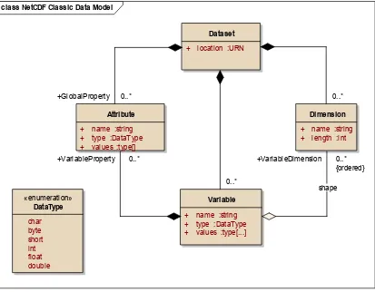
The classic NetCDF form, NetCDF-3, has a data model that allows a dataset to be described in terms of a collection of variables. Each variable has a set of dimensions that describe the size and shape of the variable array, with scalars being single, dimensionless values. Each variable, and the dataset as a whole, can be associated with a set of
attributes that provide metadata describing the variable and the dataset as a whole. Attributes and variables are typed, with a limited selection of data types. The classic NetCDF data model is shown in Figure 2.
Figure 2 — Classic NetCDF Data Model
class NetCDF Classic Data Model
Dataset
+ location :URN
Attribute
+ name :string + type :DataType + values :type[]
Dimension
+ name :string + length :int
Variable
+ name :string + type :DataType + values :type[...]
«enumeration»
DataType
char byte short int float double
+VariableProperty 0..*
shape +VariableDimension 0..*
{ordered} 0..* +GlobalProperty 0..*
The classic data model provides a simple way of presenting array-like data with minimal structure. The classic data model is described in OGC 01-090r3 OGC Network Common Data Form (NetCDF) Core Encoding Standard version 1.0. A binary encoding of the data model is described in OGC 10-092r3 NetCDF Binary Encoding Extension Standard: NetCDF Classic and 64-bit Offset Format.
A minimal set of attribute conventions for all NetCDF documents has been defined in Appendix B of the NetCDF user’s guide(Rew, et al., 2011). These conventions provide a way of documenting the name, units and valid range of a variable, as well as information about the dataset as a whole, in particular, the specific set of conventions that the dataset adheres to. Units in a NetCDF document are conventionally given using the UDUNITS library and database(Unidata Program Center, 2011).
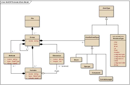
The classic NetCDF data model is widely used but is highly restrictive. An enhanced form has been developed, NetCDF-4, which provides a number of extensions:
The number of possible primitive data types has been expanded. In particular, variables may now be variable-length strings (NetCDF-3 variables intended to be strings were fixed-length character arrays);
A recursive, grouping structure has been introduced to allow hierarchies of variables and attributes; and
User-defined enumerated, compound, variable length and opaque data types may be created.
Figure 3 — Extended NetCDF Data Model
A separate binary format, based on the Hierarchical Data Format, Version 5 (HDF5) (The HDF Group, 2011) has been developed for NetCDF-4. It is possible to produce
documents encoded in the NetCDF-4 binary format but which adhere to the classic data model, called the NetCDF-4 classic model format.
The extended form is not part of any formal OGC standard, although it is included in the
OGC 10-091r3 CF-netCDF Core and Extensions Primer roadmap for further
development and a draft standard has been developed(Domenico, 2012). NetCDF-4.0 was released in 2008. Since then, there has been what has been described as a “chicken and egg logjam”(Rew, Adapting Software to NetCDF's Enhanced Data Model, 2010) where data providers and data consumers wait for the other to adopt the new standard. Most applications now support the NetCDF-4 classic model format(Rew, Update on Unidata Technologies for data Access, 2011).
Support for the enhanced data model, however, is still spotty; the NetCDF Java library is still read-only, for example. Since most of the use-cases described in Section 6 can be handled using the classic data model, the classic data model is used wherever possible. There are a few cases where the enhanced data model is desirable, identified by
(enhanced model) in the text. These usually revolve around the need to record variable-length metadata strings on a per-point basis. Generally, metadata at the timeseries or observation level can be placed in attributes or ancillary variables. However, per-point comments or complex metadata will need to be placed in a character string. Classic data model character arrays are FORTRAN-style fixed-length arrays. If fixed-length arrays
class NetCDF Extended Data Model
are used to record sparse data, such as comments, the result would be wasteful. Using an indexing strategy, similar to ragged arrays in timeseries is also possible but would require an array that can accommodate the largest possible string for each entry. The variable length strings of the enhanced data model provide a direct solution.
There are also a few cases where the use of the enhanced data model would alter the mapping strategies discussed in Section 8. As an example, the grouping mechanism provided by the enhanced data model would allow a more natural way of expressing URIs as internal references. Rather than develop a completely separate mapping for the enhanced data model, the mappings used in the classic data model are used.
7.3 NetCDF Attribute Convention for Dataset Discovery
The Attribute Convention for Dataset Discovery (ACDD) provides a set of metadata conventions that are recommended for describing NetCDF documents for discovery systems, such as digital libraries and cataloguing services(Davis, 2005). The attributes specified by the ACDD conventions provide identification, keywords and vocabulary definitions, geospatial and temporal boundaries, origins and validity information. The ACDD recommends the use of a vocabulary of standard names for variables. No specific vocabulary is recommended and the vocabulary used can be specified as part of the dataset metadata.
Use of the ACDD is highly recommended in NetCDF files. A draft set of mappings is being developed to map the ACDD conventions onto other metadata standards, such as Dublin Core, ISO 19115-2 and THREDDS.
7.4 Climate and Forecast Conventions
The Climate and Forecast (CF) conventions are a commonly used set of conventions for providing semantic information on the data contained in variables(Eaton, et al., 2011). The conventions have been accepted by the OGC as an extension to the NetCDF core in
10-091r3 CF-netCDF Core and Extensions Primer. From the point of view of this paper, the conventions provide guidance on:
Naming conventions for files, dimension and variable names;
Provision of ancillary data, such as flags, quality control or confidence levels;
Geospatial and temporal coordinates, coordinate systems and projections;
Descriptions of aggregation methods for aggregate measures; and
Sampling and timeseries methods.
The CF conventions extend the COARDS conventions(Hankin & Searight, 1995), a set of conventions that are used by many geospatial and visualisation packages to map gridded data onto a coordinate system. Similarly, the CF conventions extend the GDT
The CF conventions provide a set of conventions for discrete sampling geometries; datasets that represent paths through a larger region of space-time. The discrete sampling geometries conventions provide a standardised way of describing timeseries from
multiple sampling points, corresponding to a collection of monitoring stations.
The current WaterML timeseries standard is built around monitoring stations collecting point data. However, the WaterML model can be adapted to allow more complex data forms. In the future, stations that collect data along a horizontal line or a vertical surface may be considered, as may be the output of multi-station processes. Although the CF conventions have feature types that are very close to these cases (e.g., a timeSeriesProfile collects data along a line) these features are tied to specific axes (the timeSeriesProfile uses a vertical line). Future versions of the CF conventions may relax these restrictions. The CF conventions provide a table of standard names for the physical quantities being recorded. As implied by the name of the convention, these names are largely drawn from the terminology of the climate and forecasting domains. There are a number of terms in common use in the hydrology domain, such as turbidity, that have no standard name. There are also terms that have a common name in hydrology that have a more generic name in the CF standard names (e.g. stage is
water_surface_height_above_reference_datum). See Section 7.8 for a further discussion of standard names.
7.5 Climate Science Modelling Language
The Climate Science Modelling Language (CSML) is a data model for encoding climate, atmospheric and oceanographic data in terms of geometry-based observation classes such as points, profiles, trajectories and grids(Woolf, 2011; Natural Environment Research Council, 2011).
The CSML model defines a number of observation types that are aligned with the CF discrete sampling geometries feature types; for example Point and PointSeries in CSML correspond to point and timeSeries in CF. The CSML model also contains a number of additional observation types, such as swaths and scanning radars, that are not defined in the current CF conventions. These observation types are described in a pair of draft documents on the NetCDF web site (Unidata Program Center, 2008; Unidata Program Center, 2008).
The CSML model also contains a mechanism for embedding data documents into a larger metadata context. A CSML document contains a description of a dataset in the form of general metadata, an O&M observation and a storage descriptor. The storage descriptor describes the data storage format and how it can be accessed; e.g. as inline data or as a segment of an externally accessible file. Storage descriptors can be either embedded into a data description or reference by the XLink mechanism. For example, a NetCDF extract can be described by and referenced as:
http://opendap- qcif.arcs.org.au/thredds/dodsC/IMOS/ABOS/ASFS/SOFS/2011/IMOS_ABOS-ASFS_CMST_20110131T002900Z_SOFS_FV01.nc
</csml:fileName>
<csml:variableName>UWND</csml:variableName> </csml:NetCDFExtract>
...
<csml:rangeSet xlink:href=”#imos-uwnd”/> ...
7.6 Other Timeseries Conventions
The US National Oceanographic Data Center (NODC) Argo profiling float
conventions(Carval, et al., 2011) have been designed to support the recording of a series of profiles from the Argo free-drifting floats. The conventions allow for either a single profile or a trajectory of profiles.
The NCAR-RAF conventions(National Center for Atmospheric Research, Research Aviation Facility, 2009) support synchronous timeseries for both vectors and scalars with varying sampling rates. Data is collected at a one second sample interval. Measurements that occur at a rate higher than 1Hz are collected into additional dimensions; for example, a 25Hz signal will be broken into groups of 25 readings, aligned with other samples from the same time-period.
EPIC is a collection of libraries and software packages developed and maintained by the Pacific Marine Environmental Laboratory (PMEL). EPIC was developed to maintain the collection of datasets collected as part of NOAA climate study programs. The EPIC conventions provide simple profile and timeseries conventions, strongly oriented towards regular longitude/latitude/depth/time grids. A notable feature is that, rather than using standard names, properties are given standard numerical codes – for example, latitude has a code of 500, temperature a code of 20.
The Argo, NCAR-RAF and EPIC conventions are strongly domain-specific and specify a large number of variables and attributes that are tied to the underlying collection model and domain. These conventions could be made to fit hydrological data, but only at the cost of considerable violence to both the conventions and the data.
7.7 Choice of Conventions
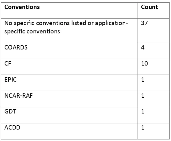
A significant motivation for the use of NetCDF for WaterML is access to the large collection of software libraries, tools and systems that use NetCDF. Choice of conventions, therefore, is also driven by the practical considerations of whether the conventions add value in terms of software use. An additional driver is the need to make the resulting NetCDF document usefully comprehensible to humans so that collected data can be reused for scientific research.
Table 1 Use of NetCDF Conventions in Software Packages
Conventions Count
No specific conventions listed or application-specific conventions
37
COARDS 4
CF 10
EPIC 1
NCAR-RAF 1
GDT 1
ACDD 1
Visualisation and graphics packages tend to either use the COARDS conventions directly or via the CF conventions. The conventions of choice, used for the rest of this document, are:
The minimal NetCDF attribute conventions defined in the NetCDF user’s guide.
The ACDD conventions. These conventions capture a subset of the metadata available from the ISO 19115 conformant data contained in a WaterML model and provide essential metadata for data reuse.
The CF conventions. These conventions are widely used and provide ways of describing timeseries, geospatial referencing, measurement annotations and vocabulary control.
In addition, it will be necessary to develop some WaterML-specific conventions to cover elements not easily modelled by the existing conventions.
7.8 Relationship Between Hydrology and NetCDF Conventions
An example of vocabulary is the CF standard name table, discussed in Section 7.4. An example of measurement methodology is the use of vertical sampling profiles in the natural domains of the CF, CSML and Argo conventions.
Some standards provide administrative methods for expansion. For example, there is a mechanism for constructing and adding new standard names to the CF conventions. However, it is not clear that the hydrology vocabulary should be imported into the CF standard name table. A separate standard name vocabulary, possibly constructed according to the CF guidelines and format may be preferable. In general, it is not clear that hydrology- and WaterML-specific constructs should be added to conventions oriented towards other domains. For the purposes of this paper, separate sets of
conventions are assumed to have been developed where necessary and mechanisms for specifying the vocabularies used have been developed. Wherever possible, these
conventions should use the patterns of existing conventions, so that they can be adsorbed back into the existing conventions at a later date.
8 Mapping Strategies
8.1 Mapping Names, URIs and Tokens
Standard terms in WaterML tend to be either URIs, preferably URIs that resolve to semantic information, or terms drawn from controlled vocabularies, with the vocabularies referenced. An example standard term in WaterML is the URI
http://www.opengis.net/WaterML/2.0/def/quality/goodwhich is resolves to a semantic
description of the meaning of “good quality”.
Standard terms in NetCDF documents tend to be tokens, words or phrases connected by underscores, or enumerated values. As an example, the equivalent to “good quality” in NetCDF would be a token such as quality_good. The meaning of the tokens and enumerations in NetCDF is generally defined by reference to a manual or conventions document, referenced by use of the Conventions attribute and by further attributes.2 The tokens in NetCDF fulfil the function of URIs; unambiguous references to concepts. Since a WaterML model is likely to draw vocabularies from several sources, including the URIs contained in the WaterML standard, mechanisms for mapping URIs and controlled vocabularies onto tokens or enumerations need to be developed, as do mechanisms for mapping the resulting tokens back onto definitions.
The enhanced NetCDF model allows enumerations to be directly specified. In keeping with the policy of avoiding conventions that require the enhanced model, use of enhanced model enumerations is not considered.
8.1.1 Standard Names
The standard names used in the CF conventions are a special case of a NetCDF standard term. They are designed to provide an unambiguous reference to the property that a variable measures. The CF standard name table provides a small amount of semantic information: canonical units, descriptive text, aliases and mappings onto a small number of similar codes. However, standard names are generally used in software simply to ensure that like is compared with like.
Where possible, the variables in the document should have a standard name that reflects the property of the observation. If the standard name is taken from a specific vocabulary, the vocabulary should be recorded in the observation metadata and specified in the NetCDF global attributes (see Section 10.2). Where standard names can be mapped onto URIs, a dictionary should be included (see Sections 8.1.4 and 10.4.1)
Standard names can be derived from either a repository of standard names, such as the CF name table, by tokenizing a property URI (see Section 8.1.2) or by using data available from RDF (see Section 8.1.3).
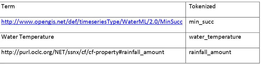
8.1.2 URI Tokenization
Enumerations for URIs or terms from a standardized vocabulary can be constructed by tokenizing either the xlink:title value from the link to the URI, the fragment of the URI, the last path segment of the URI or the label or id of an AbstractSWEType. Tokenizing replaces whitespace and other non-alphanumeric characters with underscores and converts camelcase to lower case separated with underscores. For example:
Table 2 URI Tokenization Examples
Term Tokenized
http://www.opengis.net/def/timeseriesType/WaterML/2.0/MinSucc min_succ
Water Temperature water_temperature
http://purl.oclc.org/NET/ssnx/cf/cf-property#rainfall_amount rainfall_amount
Tokenized URIs can be associated with the actual URI by use of a dictionary – see Section 8.1.4.
8.1.3 Use of RDF
For example, the following RDF description of rainfall is extended from the CF
properties ontology3, developed by the Semantic Sensor Networks working group. The rdfs:label property can be used to derive a suitable long name and the cf:standardName can be used for the CF standard name.
<dim:SurfaceDensity rdf:about="http://purl.oclc.org/NET/ssnx/cf/cf-property#rainfall_amount">
<rdfs:label>Rainfall Amount</rdfs:label>
<rdfs:comment>"Amount" means mass per unit area.</rdfs:comment> <dc:source>Climate and Forecast (CF)</dc:source>
<cf:standardName>rainfall_amount</cf:standardName> <qu:generalQuantityKind>
<dim:SurfaceDensity
rdf:about="http://purl.oclc.org/NET/ssnx/qu/quantity#surfaceDensity"/> </qu:generalQuantityKind>
<ssn:isPropertyOf>
<cf-feature:Precipitation rdf:about="http://purl.oclc.org/NET/ssnx/cf/cf-feature#rainfall"/>
</ssn:isPropertyOf> <qu:propertyType>
<qu:PropertyKind rdf:about="http://purl.oclc.org/NET/ssnx/qu/quantity#scalar"/> </qu:propertyType>
</dim:SurfaceDensity>
8.1.4 Dictionaries and Vocabularies
Terms drawn from standard vocabularies in a WaterML model need to be reduced to tokens and enumerations. Tokens and enumerations used within a NetCDF document may need to be directly associated with their meanings, rather than by reference to a conventions document. This section outlines a strategy for constructing terms and
enumerations from the URIs and vocabularies in a WaterML document and providing an embedded dictionary within the document.
For enumerated variables, the CF conventions specify a set of conventions for describing flag values. These conventions are largely concerned with supplying ancillary data, such as quality control attributes, but can be adapted to more general dictionary roles.
To provide a dictionary for an enumeration, three attributes need to be specified:
flags_mask, flags_values and flags_meanings. The first, flags_mask, is
a vector of masks intended to allow multiple flag values within a single variable. The actual values of the enumeration are listed in the vector flags_values. The meanings of the flags, as tokens, are listed in a space-separated string. For example:
weather:flags_mask = 7b;
weather:flags_values = 1b, 2b, 3b, 4b, 5b, 6b;
weather:flags_meanings = “fine cloudy showers rain snow hail”;
The use of the flags attributes allows an enumeration to be mapped onto a set of tokens. The tokens then need to be associated, if possible, with a dictionary.
in the WaterML model. The flags_vocabulary attribute is the URI of the vocabulary or the name of an attribute containing a dictionary (see below).
Where possible, the flags_vocabulary_typeof attribute should describe the type or class of vocabulary, in keeping with the terminology of (Lefort, 2009). The
flags_vocabulary_typeof attribute can be a URI, a mime type or descriptive
text. For example, a SKOS vocabulary might have a flags_vocabulary_typeof
of http://www.w3.org/2004/02/skos/core#ConceptScheme or text/x-skos.
It may be necessary to directly supply the vocabulary dictionary, particularly if the vocabulary consists of tokenised URIs. Dictionaries that have an XML document-like structure, such as SKOS concept schemes or WaterML local GML dictionaries can be directly embedded into the attribute and identified by the typeof attribute. The
flags_dictionary attribute contained the embedded dictionary.
In the case of tokens are derived from URIs, a simple dictionary of URIs can be
constructed by defining a simple space-separated key=value dictionary, mapping tokens onto URIs4. The flags_vocabulary_typeofattribute in this case is “simple”. For example:
weather:flags_vocabulary = “flags_dictionary”; weather:flags_vocabulary_typeof = “simple”; weather:flags_dictionary =
“fine=http://sweet.jpl.nasa.gov/2.3/stateVisibility.owl#Sunny cloudy=http://sweet.jpl.nasa.gov/2.3/stateVisibility.owl#Cloudy
...”;
Vocabularies and dictionaries for terms other than variable enumerations can be constructed using the patterns described above.
8.2 General Metadata
8.2.1 External Metadata
Although not strictly part of the ACDD conventions, a metadata_link attribute has been introduced to allow references to more complete metadata(NOAA GEO-IDE, 2011). Since a WaterML model is a profile of an O&M model, the observation can reference a metadata object that contains ISO 19115 metadata. If the NetCDF document has been generated from a WaterML document that can be referenced by a URI, the
metadata_link attribute can be set to the document fragment that contains the
observation metadata.
More generally, an instance of WaterML is likely to contain a number of references to external objects. Features of interest (FOIs), process descriptions, datums and other objects likely to be common to multiple observations are all likely to be included as
4 In keeping with common programming language syntax for dictionaries, key:value would be preferred. However,
references. Generally, these objects tend to be ancillary contextual information, not immediately necessary to the comprehension of the data. The major exception to this rule is that it may be necessary to process the FOI so that location data can be extracted. A linked open data approach to external objects is taken(Lefort, 2009). Links to external objects can be added as attributes. Wherever possible, a pair of attributes is used. The basic attribute contains the name or title of the object. The link attribute contains the URI of the object. This approach modifies the NetCDF linked data pattern proposed in
(Bigagli, Lorenzo, & Nativi, 2011) to cover multiple links and to keep with the metadata link pattern in the ACDD conventions. For example, a reference to a sampled feature might be:
:sampled_feature = “Lake George”;
:sampled_feature_link = “http://www.example.com/foi/LG”;
8.2.2 Embedded Metadata
There are a large number of attributes in the CF and ACDD conventions that can be directly translated from and to elements of a WaterML model. Section 10 discusses the mappings between the WaterML model and specific attributes. Even if this metadata is repeated, either internal to the NetCDF document or via an external link, these attributes should be present, if possible, since they are the attributes most likely to be used by processing software.
Complete metadata on observations, results or individual data points may also need to be included, if the document is intended as an archival form of the model. The metadata attached to even a single data point of a WaterML timeseries can be quite complex. As a consequence, attempting to provide NetCDF-style attributes or flags for all but the most common and useful metadata would represent a great deal of additional complexity for little return.
Instead, complete metadata can either be added to attributes or variables in the form of XML documents conforming to the WaterML XML encoding. Each document would need to be a stand-alone document, including namespace declarations. A reader could then reconstruct the WaterML model by processing the documents and attaching them to the model. (enhanced model) Use of XML in variables, when complete per-point
metadata is included in the document, necessitates the use of the string data type from the enhanced model.
8.2.3 Default Metadata
WaterML 2.0 allows the specification of default metadata values for certain things, such as units or interpolation types. If a NetCDF dataset is imported into a WaterML model, sensible default metadata needs to be constructed. There are two strategies for
constructing the default metadata:
Additional attributes are attractive, since they enrich the semantic data available without imposing a great deal of processing overhead.
The interpolation type metadata corresponds to a timeseries implementation of CF conventions cell methods. If a timeseries has a single, consistent interpolation type, then the cell methods variables can be used to accurately characterise the time bounds of the interpolation type – see Section 8.7.
8.3 Units
Units of measure in WaterML are specified using the Unified Code for Units of Measure (UCUM)(Schadow & McDonald, 2009). NetCDF conventions use the UDUNITS-2 unit database (Unidata Program Center, 2011). Both of these systems provide a mechanism for the specification of units in an unambiguous manner.
In most cases, the differences between UCUM and UDUNITS-2 systems are syntactic and the units can be readily translated. One exception is that NetCDF attributes referring to longitude and latitude use units of degrees_east and degrees_north, attaching an additional level of interpretation to the unit. In practice, this extra requirement is unlikely to represent a difficulty, as it should be obvious when a location is being used. The WaterML standard allows changes in units within the timeseries by per-point metadata. NetCDF variables have a single unit for the entire variable. NetCDF-encoded WaterML, therefore, needs to have a single default unit for all measurements.
8.4 Categories and Measurements
Simple measurements in WaterML are UML double precision numbers, represented by XML schema doubles in the XML encoding.
Categories represent qualitative data that, in WaterML, are described by terms drawn from a controlled vocabulary. Category data can be either encoded as an array of characters, or a string in the enhanced model, or by creating an enumeration and providing a dictionary – see Section 8.1.4.
A simple approach to category data is to simply use arrays of characters and provide the category names for each data point. However, classic model character arrays are of a fixed size and tend to be wasteful. Instead, existing conventions such as the Argo float conventions tend to encode category data as enumerations with the meaning of the enumeration given in a reference document. This approach is considerably more space-efficient and emphasises the controlled nature of the terminology. Since the category vocabulary is known ahead of time, the enumeration/dictionary approach is preferred.
8.5 Locations
associated with each measurement. The conventions for describing CF discrete sampling geometries are discussed in Section 9.
Hydrological observations are generally of a feature of interest (FOI) – a river, a lake or some other geographical feature. WaterML observations are generally, but not
exclusively, generated by sensors located at monitoring points. WaterML uses the O&M sampling features model to describe one or more monitoring points that sample a larger FOI. If the observation FOI is a sampling feature, timeseries locations can be derived from the sampling points described in the FOI.
In the case of sampling features, the sampled feature is generally an important part of the dataset metadata. The sampled feature should also be referenced in the NetCDF
document – see Section 10.4.1.
If the FOI is not a sampling feature, the timeseries location will need to be derived from the FOI itself. If the timeseries represents a value that covers the entire feature, the CF spatial cell boundaries, using a p-sided cell for irregular features, can be used to describe the location of the timeseries.
If the location data can be derived from a timeseries itself, for example a series of GPS readings from a mobile sensor, the trajectory feature type can be used to encode the location timeseries – see Section 9.
8.6 Coordinate Reference Systems
The CF conventions provide a mechanism for specifying the coordinate reference system (CRS) used when specifying locations. A suitably named scalar variable contains
attributes that describe the coordinate system, with the main type of the coordinate system described by a grid_mapping_name attribute. A variable that uses the
specified coordinate system uses the grid_mapping attribute to name the variable that describes the
Individual points, such as monitoring points can usually be reliably geolocated and can be expressed as latitude and longitude. GML locations usually have a reference system specified by the srsName attribute, which can refer to an EPSG (International Association of Oil & Gas Producers, 2011) OGC URN(Whiteside, 2007). For example, the URN of
urn:ogc:def:crs:EPSG::4326 refers to the WGS84 CRS, which can be specified using the CF conventions as:
variables: int WGS84 ;
WGS84:grid_mapping_name = "latitude_longitude"; WGS84:longitude_of_prime_meridian = 0.0 ; WGS84:semi_major_axis = 6378137.0 ;
WGS84:inverse_flattening = 298.257223563 ;
coordinate reference system used by the grid. The following example shows a mapping for a timeseries where the sampling grid is based on the Map Grid of Australia 1994 in zone 55(Intergovermenal Committee on Surveying and Mapping, 2009)
dimensions:
x:standard_name = "projection_x_coordinate" ; x:units = "m" ;
double y(station, y) ;
y:standard_name = "projection_y_coordinate" ; y:units = "m" ;
double lat(station, y, x); lat:units = "degrees_north"; double lon(station, y, x); lat:units = "degrees_east";
float temperature(station, time, y, x) ; temperature:standard_name = "temperature" temp:long_name = "water temperature" ; temp:units = "degC" ;
temp:coordinates = "lat lon" ; temp:grid_mapping = "MGA94_55" ; int MGA94_55 ;
MGA94_55:grid_mapping_name = "transverse_mercator"; MGA94_55:scale_factor_at_central meridian = 0.9996 ; MGA94_55:longitude_of_central_meridian = 147.0 ; MGA94_55:latitude_of_projection_origin = 0.0 ; MGA94_55:semi_major_axis = 6378137.0000; AMG84_55:semi_minor_axis = 6356752.3141; AMG84_55:inverse_flattening = 298.257222101; AMG84_55:false_easting = 500000.0 ;
AMG84_55:false_northing = 10000000.0;
In this example, the x and y variables contain the x and y coordinates of the grid,
according to the MGA94 grid. The lat and lon variables map the x and y coordinates onto latitudes and longitudes.
8.7 Representation of Aggregated Values
Many WaterML measurements represent some sort of aggregate value collected over a time period – for example, a maximum temperature. The WaterML interpolation type describes the aggregation process. The following section provides a way of explicitly representing the aggregation process in a form that conforms to the cell representation of the CF conventions. The resulting data mixes a number of WaterML elements together in a way that is likely to make it impossible to reconstruct WaterML from the resulting cell representation. The results of this section simply provide a representation of aggregated data that can be interpreted by suitable CF-aware software.
The CF conventions describe a way of specifying the cell boundaries for measurements that represent some characteristic of the entire cell in a grid, rather than point
The WaterML specification does not explicitly define how spatial cells are specified, since monitoring points have a point geometry and the current WaterML profile does not explicitly cover the results of the sort of complex data products that might produce grids(Taylor, 2010, p. 11). For this reason, spatial cells are not considered in this
document beyond noting that a non-sampling FOI could be used to define cell boundaries – see Section 8.5.
Cells can also refer to cell in the temporal, as well as spatial, dimension, for timeseries that represent accumulated values collected over some period. An example timeseries cell would be the measurements from a tipping bucket.
The WaterML specification does provide enough information to build cell boundaries for cumulative measurements. The default interpolation type is used to model the type of accumulation. If the interpolation type specifies a preceding-type of interpolation, then the cell boundaries are constructed between the time of the previous data point and the time of the current data point. If the interpolation type is a succeeding-type of
interpolation, then the cell boundaries are constructed between the time of the current data point and the time of the next data point. If the start or end anchor points exist, then they can be used as the preceding or succeeding times for the first and last points in the timeseries respectively. If anchor points do not exist, then the temporal extent of the timeseries can be used to mark the start and end of cell bounds. If the time distance between two points exceeds the maxGapPeriod, then the bounds start or end at the
maxGapPeriod before or after the current point.
If a timeseries is cumulative, then natural cell boundaries may be better represented by the accumulation anchor time and accumulation interval. However, the cell boundaries conventions reflect the boundaries of individual data points, rather than cumulative sequences. At a future stage, an extension to group timeseries data into samples, in the style of an NCAR-RAF timeseries (see Section 7.6) could be considered to cover this case.
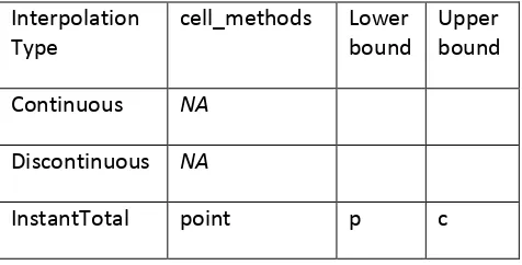
Table 3 gives a summary of time bounds construction. If the time variable is called time
then the bounds variable can be called time_bounds and the bounds constructed from the interpolation type using the following table. Similarly, it indicates the
cell_methods method that applies to the WaterML interpolation type.
Table 3 Interpolation Type – Cell Methods Mapping
Interpolation Type
cell_methods Lower bound
Upper bound
Continuous NA
Discontinuous NA
AveragePrec mean p c
MaxPrec maximum p c
MinPrec minimum p c
TotalPrec sum p c
ConstPrec mode? p c
AverageSucc mean c s
MaxSucc maximum c s
MinSucc minimum c s
TotalSucc sum c s
ConstSucc mode? c s
Where p means the time of the preceding point, or the start anchor point, beginning time extent or time of the current point less the maximum gap, as appropriate, c means the time of the current point and s the time of the successor point, modified in the same way as the preceding point.
The constant interpolation types are intended to represent constant values, such as an alarm setting. There is no real equivalent to the constant interpolation type in the CF conventions. The use of mode for the method is based on a constant value being the setting for the majority of the readings gathered in the cell.
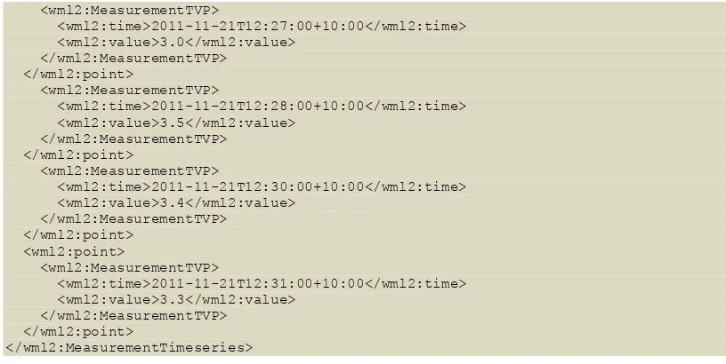
As an example, consider the following XML-encoded WaterML 2.0 timeseries:
<wml2:MeasurementTimeseries > <wml2:temporalExtent>
<gml:TimePeriod>
<gml:beginPosition>2011-11-21T12:27:00+10:00</gml:beginPosition> <gml:endPosition>2011-11-21T12:30:00+10:00</gml:endPosition> </gml:TimePeriod>
</wml2:temporalExtent> <wml2:metadata>
<wml2:MeasurementTimeseriesMetadata>
<wml2:startAnchorPoint>2011-11-21T12:26:00+10:00</wml2:startAnchorPoint> </wml2:MeasurementTimeseriesMetadata>
</wml2:metadata>
<wml2:defaultPointMetadata>
<wml2:DefaultTVPMeasurementMetadata>
<wml2:uom uom="http://www.opengis.net/def/uom/UCUM/0/m"/> <wml2:interpolationType
xlink:href="http://www.opengis.net/def/timeseriesType/WaterML/2.0/MaxPrec" xlink:title="Maximum Preceding"/>
</wml2:DefaultTVPMeasurementMetadata> </wml2:defaultPointMetadata>
<wml2:MeasurementTVP>
<wml2:time>2011-11-21T12:27:00+10:00</wml2:time> <wml2:value>3.0</wml2:value>
</wml2:MeasurementTVP> </wml2:point>
<wml2:MeasurementTVP>
<wml2:time>2011-11-21T12:28:00+10:00</wml2:time> <wml2:value>3.5</wml2:value>
</wml2:MeasurementTVP> </wml2:point>
<wml2:MeasurementTVP>
<wml2:time>2011-11-21T12:30:00+10:00</wml2:time> <wml2:value>3.4</wml2:value>
</wml2:MeasurementTVP> </wml2:point>
<wml2:point>
<wml2:MeasurementTVP>
<wml2:time>2011-11-21T12:31:00+10:00</wml2:time> <wml2:value>3.3</wml2:value>
</wml2:MeasurementTVP> </wml2:point>
</wml2:MeasurementTimeseries>
which would have the following NetCDF representation:
dimensions:
time = UNLIMITED; station = 1; bounds = 2; variables:
double maximum_stage(station, time); maximum_stage:long_name = “maximum stage”; maximum_stage:units = “m”;
maximum_stage:cell_methods = “time: maximum”; int time(station, time);
time:standard_name = “time”;
time:units = “seconds since 2011-11-21 12:27:00 +10:00”; time:bounds = “time_bounds”;
int time_bounds(station, time, bounds); data:
time = 0, 60, 180, 240;
time_bounds = -60, 0, 0, 60, 60, 180, 180, 240; maximum_stage = 3.0, 3.5, 3.4, 3.3;
8.8 Ranges
NetCDF variables have a number of attributes designed to provide guidance to a reader on the likely range of a variable. Since NetCDF documents can be large and can be partially read, the range attributes can supply useful hints to tools such as plotting programs. WaterML has time-range metadata but no value-range metadata. Prior to generating a NetCDF encoding, the timeseries needs to be scanned and sensible ranges computed.5 The attributes that supply range information are shown in Table 4.
Table 4 Standard NetCDF Range Attributes
Attribute Description Derivable From
valid_min The minimum valid value for this variable. This may
Semantic data for the timeseries property – see Section 8.1.3
be below the minimum actual value of the variable.
The actual minimum
The actual minimum rounded down to a human-friendly value (eg. -10.0 for an actual minimum of -7.7)
valid_max The maximum valid value for this variable. This may be below the minimum actual value of the variable.
See valid_min
valid_range A vector of the valid_min and valid_max if both are defined. This attribute replaces valid_min and valid_max if both are present.
_FillValue The value to fill allocated but unused space allocated to the variable.
A value outside the valid range. Ideally, this should be a readily recognisable value an order of magnitude or so beyond the valid range. For example, if the valid minimum was -10.0 then a fill value of -99.9 would be easily
recognisable.
If the variable is an enumeration, then the missing value (0) should be used.
missing_value The specific value used to indicate missing data.6
Set to the _FillValue
It is also possible to define transformations, using the scale_factor and
add_offset attributes, to pack data. This paper does not consider scale
transformations, although they could be applied to timeseries data.
As an example, a timeseries with the values -2.5, 3.4, 5.6, 8.9, -5.6 might have the following range attributes:
example:valid_range = -10.0, 10.0; example:_FillValue = -99.9; example:missing_value = -99.9;
8.9 Responsible Parties
The ACDD conventions contain a number of attributes that describe actors and
responsible parties. The observation metadata contains ISO 19115 compliant metadata. The GEO-IDE project has mapped a number of ISO 19115 metadata entries onto the ACDD conventions (NOAA GEO-IDE, 2011). These mappings form the core of the mapping between WaterML observation metadata and the ACDD conventions, modified when the WaterML metadata contains more specific information. The mapping is
described further in Section 10.2. 8.10Data Structures
Timeseries in WaterML can be represented as either interleaved time-value pairs or as separate domain-range sequences. Timeseries in NetCDF are always structured in domain-range form, with separate arrays for the timestamp and the value. This is true even if you use the compound construct of enhanced mode, since compounds appear to be internally translated into the domain-range form.
To allow NetCDF to be correctly read into a WaterML model, an additional global attribute with the intended structure (interleaved or domain-range) can be used to give a hint to the reader.
8.11Data Payload Conventions
In the case of NetCDF as a data payload, the NetCDF document represents a timeseries. The parent document will be an O&M observation conforming to the WaterML profile with a result that refers to the NetCDF document. If the observation has a suitable URI, then the metadata_link attribute in the NetCDF document (see Section 8.2.1) should refer to the observation metadata.
The link to the payload uses the Xlink conventions. In keeping with (Lefort, 2009), the
xlink:role is either the URI of the NetCDF format or the NetCDF mime type of
application/x-netcdf
8.12Reconstruction of WaterML Models from NetCDF documents
This paper largely considers the creation of a NetCDF document from a WaterML model. However, the mappings discussed in Sections 8-10 are intended to allow the construction of a WaterML model from a suitably encoded NetCDF document.
Embedding XML representations of metadata into a NetCDF document (see Section 8.2.2) ensures that a complete model can be constructed. In many cases, embedded XML will not be present and the model needs to be constructed from the data and attributes contained in the document.
attribute. Additional metadata is introduced in Section 10.4 to ensure that terms can be correctly interpreted and mapped onto WaterML terminology.
In the case of measurement timeseries, the timeseries values and metadata can be extracted directly from the variables containing the time, value and ancillary data. Features of interest are monitoring points, modelled as stations by the timeseries
encoding. The names and locations of monitoring points can be derived from the location information contained in the timerseries variables, along with any coordinate reference systems. Additional monitoring point data can be derived from the global attributes. 9 Encoding of Timeseries
The CF conventions for discrete geometries provide a consistent way of describing timeseries.
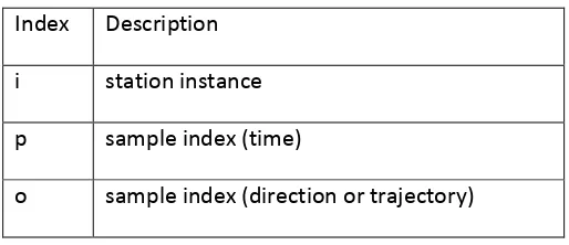
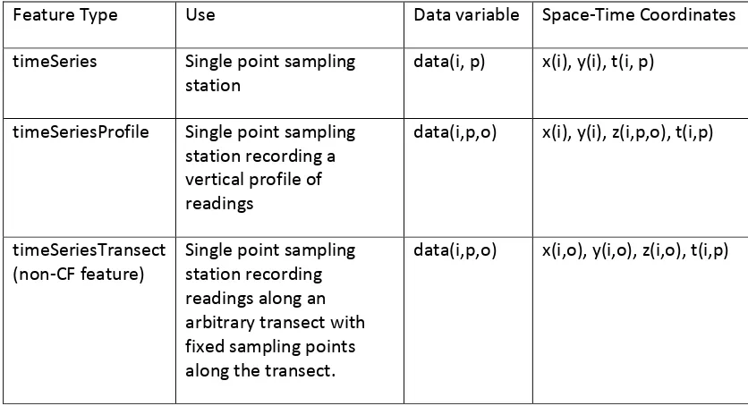
Timeseries can be recorded over a number of indices. In the following examples, the index names refer to the following dimensions:
Table 5 Timeseries Indices
Index Description
i station instance
p sample index (time)
o sample index (direction or trajectory)
In many cases, the document will only contain a single station. Where there is a dimension of size one and the dimension refers to some top-level data common to the entire document, the dimension is often dropped and the variables become scalars. This practice improves the readability of NetCDF documents. However, dropping dimensions (and indices) complicates software that needs to read and comprehend the data. Dropping dimensions also decouples timeseries from station information, such as location. Rather than follow this practice, consistency is recommended, with the station index always retained.
Generally, a WaterML document contains a single timeseries, which can be simply mapped onto a single station. If a collection contains timeseries of the same type and time period, then they can be encoded using station indices.