Open Geospatial Consortium
Publication Date: 2015-02-02 Approval Date:2014-12-05
Posted Date:2014-11-13
Reference number of this document:OGC 14-044
Reference URL for this document:http://www.opengis.net/doc/PER/testbed10_summary_er
Category: Public Engineering Report
Editor:Lew Leinenweber
OGC
®Testbed 10 Summary Engineering Report
Copyright © 2015 Open Geospatial Consortium.
To obtain additional rights of use, visit http://www.opengeospatial.org/legal/
Warning
This document is not an OGC Standard. This document is an OGC Public
What is the OGC Testbed 10?
The Open Geospatial Consortium (OGC) is the only international organization that brings industry players together to help organizations manage risks and difficulties that relate to communication about real-world location and mobility. The OGC combines rapid
prototyping, standards development, coordination with other standards organizations, and aggressive standards marketing to address users' challenging geospatial integration problems.
Over the last 18 years, the OGC's Member organizations have developed a unique and proven interoperability testbed process that saves invested time and money while creating new business opportunities and driving innovation. The OGC Interoperability Program plans and conducts plugfests, pilots and the annual OGC Testbed.
This report summarizes the results of OGC Testbed 10. Testbed 10 sponsorship totaled $1.2 million USD and attracted in-kind contributions by participants of approximately $1.6 million USD for a 2.3x return on investment. Testbed requirements were provided by eleven (11) sponsors from the US, Canada and Europe. Requirements ranged from environmental management and civil government mapping to maintaining common operating pictures in disaster zones and battlefields. Twenty-nine (29) participating organizations, working on specific interoperability problems detailed in the sponsors' use cases and scenarios, delivered extraordinary value in the following areas:
Cross-Community Interoperability (CCI): Increase Geospatial community
interoperability by building on Testbed 9 CCI work in semantic mediation, volunteer geographic information (VGI), provenance and data quality, and the Global
Gazetteer. Explore the potential of interoperability in the hydrology domain utilizing semantic mediation and ontologies to more easily share and visualize geospatial data.
Open Mobility: Explore the geospatial standards requirements needed to support the growing mobile environment where client applications are mobile and information services are mobile and increasingly distributed across cloud infrastructures. The Open Mobility thread addressed these requirements while leveraging on the work achieved in Testbed 9 in the areas of OGC GeoPackage and GeoPackaging services and new OWS Context encodings.
Aviation: Demonstrate use of the Aeronautical Information Exchange Model
(AIXM), the Flight Information Exchange Model (FIXM), and Weather Information Exchange Model (WXXM) to build on the work accomplished in prior OGC testbeds to advance the applications of OGC Web Services standards in next generation air traffic management systems to support European and US aviation modernization programs.
Document type: OGC® Public Engineering Report Document subtype: NA
OGC 14-044
Copyright © 2015 Open Geospatial Consortium. iii
License Agreement
Permission is hereby granted by the Open Geospatial Consortium, ("Licensor"), free of charge and subject to the terms set forth below, to any person obtaining a copy of this Intellectual Property and any associated documentation, to deal in the Intellectual Property without restriction (except as set forth below), including without limitation the rights to implement, use, copy, modify, merge, publish, distribute, and/or sublicense copies of the Intellectual Property, and to permit persons to whom the Intellectual Property is furnished to do so, provided that all copyright notices on the intellectual property are retained intact and that each person to whom the Intellectual Property is furnished agrees to the terms of this Agreement.
If you modify the Intellectual Property, all copies of the modified Intellectual Property must include, in addition to the above copyright notice, a notice that the Intellectual Property includes modifications that have not been approved or adopted by LICENSOR. THIS LICENSE IS A COPYRIGHT LICENSE ONLY, AND DOES NOT CONVEY ANY RIGHTS UNDER ANY PATENTS THAT MAY BE IN FORCE ANYWHERE IN THE WORLD.
THE INTELLECTUAL PROPERTY IS PROVIDED "AS IS", WITHOUT WARRANTY OF ANY KIND, EXPRESS OR IMPLIED, INCLUDING BUT NOT LIMITED TO THE WARRANTIES OF MERCHANTABILITY, FITNESS FOR A PARTICULAR PURPOSE, AND NONINFRINGEMENT OF THIRD PARTY RIGHTS. THE COPYRIGHT HOLDER OR HOLDERS INCLUDED IN THIS NOTICE DO NOT WARRANT THAT THE FUNCTIONS CONTAINED IN THE INTELLECTUAL PROPERTY WILL MEET YOUR REQUIREMENTS OR THAT THE OPERATION OF THE INTELLECTUAL PROPERTY WILL BE
UNINTERRUPTED OR ERROR FREE. ANY USE OF THE INTELLECTUAL PROPERTY SHALL BE MADE ENTIRELY AT THE USER’S OWN RISK. IN NO EVENT SHALL THE COPYRIGHT HOLDER OR ANY CONTRIBUTOR OF
INTELLECTUAL PROPERTY RIGHTS TO THE INTELLECTUAL PROPERTY BE LIABLE FOR ANY CLAIM, OR ANY DIRECT, SPECIAL, INDIRECT OR CONSEQUENTIAL DAMAGES, OR ANY DAMAGES WHATSOEVER RESULTING FROM ANY ALLEGED INFRINGEMENT OR ANY LOSS OF USE, DATA OR PROFITS, WHETHER IN AN ACTION OF CONTRACT, NEGLIGENCE OR UNDER ANY OTHER LEGAL THEORY, ARISING OUT OF OR IN CONNECTION WITH THE IMPLEMENTATION, USE, COMMERCIALIZATION OR PERFORMANCE OF THIS INTELLECTUAL PROPERTY. This license is effective until terminated. You may terminate it at any time by destroying the Intellectual Property together with all copies in any form. The license will also terminate if you fail to comply with any term or condition of this Agreement. Except as provided in the following sentence, no such termination of this license shall require the termination of any third party end-user sublicense to the Intellectual Property which is in force as of the date of notice of such termination. In addition, should the Intellectual Property, or the operation of the Intellectual Property, infringe, or in LICENSOR’s sole opinion be likely to infringe, any patent, copyright, trademark or other right of a third party, you agree that LICENSOR, in its sole discretion, may terminate this license without any compensation or liability to you, your licensees or any other party. You agree upon termination of any kind to destroy or cause to be destroyed the Intellectual Property together with all copies in any form, whether held by you or by any third party. Except as contained in this notice, the name of LICENSOR or of any other holder of a copyright in all or part of the Intellectual Property shall not be used in advertising or otherwise to promote the sale, use or other dealings in this Intellectual Property without prior written authorization of LICENSOR or such copyright holder. LICENSOR is and shall at all times be the sole entity that may authorize you or any third party to use certification marks, trademarks or other special designations to indicate compliance with any LICENSOR standards or specifications.
This Agreement is governed by the laws of the Commonwealth of Massachusetts. The application to this Agreement of the United Nations Convention on Contracts for the International Sale of Goods is hereby expressly excluded. In the event any provision of this Agreement shall be deemed unenforceable, void or invalid, such provision shall be modified so as to make it valid and enforceable, and as so modified the entire Agreement shall remain in full force and effect. No decision, action or inaction by LICENSOR shall be construed to be a waiver of any rights or remedies available to it.
Contents
Page1 Overview ... 5
1.1 Document contributor contact points ... 6
2 Sponsoring Organizations ... 7
3 OGC Testbed 10 Interoperability Program Team ... 7
4 List of Participating Organizations ... 8
5 Schedule ... 8
6 Development Threads ... 9
6.1 Aviation ... 9
6.2 Cross-Community Interoperability (CCI) ... 11
6.3 Open Mobility ... 13
Tables
Page Table 1, OGC Testbed 10 Milestone Schedule ... 8Table 2, Aviation Thread ERs ... 11
Table 3, Aviation Thread Software Components ... 11
Table 4, CCI Thread ERs ... 12
Table 5, CCI Thread Software Components ... 13
Table 6, Open Mobility Thread ERs ... 14
Table 7, Open Mobility Software Components ... 14
Attention is drawn to the possibility that some of the elements of this document may be the subject of patent rights. The Open Geospatial Consortium shall not be held
responsible for identifying any or all such patent rights.
Testbed 10 Summary Engineering Report OGC 14-044
Copyright © 2015 Open Geospatial Consortium. 5
OGC
®Testbed 10 Summary Engineering Report
Summary OGC Testbed 10
1 Overview
The OGC Testbed 10 was an initiative of OGC’s Interoperability Program to
collaboratively extend and demonstrate OGC’s baseline for geospatial interoperability. The majority of work for Testbed 10 was conducted between October 2013 and April 2014. Key outcomes are:
40 Software Components (servers, clients, tools and other applications) were implemented and used in interoperability testing.
19 Engineering Reports (ERs) were written. Testbed 10 ERs were either technical specifications or reports regarding testing and analysis. Several Change Requests were also developed as recommendations for changes to existing standards. These CRs were entered into the OGC’s change request tracker:
http://www.opengeospatial.org/standards/cr
Testbed 10 ERs were posted to the OGC Standards Program Pending Documents archive and have either been approved for public release or are being reviewed by OGC TC members for public release. Engineering reports approved for public release are accessible on the web here:
http://www.opengeospatial.org/standards/per
11 Sponsoring organizations defined requirements for Testbed 10. The sponsors’ requirements were captured in the Request For Quotations/Call For Participation (RFQ/CFP) document that was released by OGC 15 July 2013 seeking
organizations that wished to participate in the Testbed.
40 organizations in total participated in some aspect of Testbed 10. Roles for organizations in Testbed 10 included sponsors, participants and architects. Additionally there were many organizations that were observers of Testbed 10.
o A presentation and demonstration of the results of Testbed 10 was
performed during the OGC’s Technical Committee meeting in
Cross-Community/Open Mobility Thread. Proceedings of these demonstrations were recorded and are available online here:
Testbed 10 Presentation and Demonstration:
Part 1: https://www.youtube.com/watch?v=l3TJRini5XQ
Part 2: https://www.youtube.com/watch?v=0vXsq9nj7Cg
Testbed 10 Aviation Thread Webinar:
https://www.youtube.com/watch?v=UXDCRkMVSa4
Testbed 10 Cross-Community and Open Mobility Threads Webinar:
https://www.youtube.com/watch?v=3WwaLyZeSug
1.1 Document contributor contact points
All questions regarding this document should be directed to the editor or the contributors:
Name Organization
OGC 14-044
Copyright © 2015 Open Geospatial Consortium. 7
2 Sponsoring Organizations
OGC Testbed 10 was sponsored by the following 11 organizations:
AGC (Army Geospatial Center, US Army Corps of Engineers)
ESA (European Space Agency)
EUROCONTROL
FAA (US Federal Aviation Administration)
GeoConnections - Natural Resources Canada
Harris Corporation
Lockheed Martin Corporation
NGA (US National Geospatial-Intelligence Agency)
NOAA National Weather Service (NWS)
USGS (US Geological Survey)
UK DSTL (UK Defence Science and Technology Lab)
3 OGC Testbed 10 Interoperability Program (IP) Team
The IP Team is an engineering and management team to oversee and coordinate OGC Interoperability Initiatives. The IP Team facilitates architectural discussions, synopsizes technology threads, and supports the candidate standard editorial process. The IP Team is comprised of OGC staff and representatives from member organizations. The Testbed 10 IP Team was:
Interoperability Program Executive Director: Dr. Nadine Alameh, OGC
Initiative Director: Lew Leinenweber, OGC
Thread Architects
o Aviation: Johannes Echterhoff, interactive instruments o Cross-Community Interoperability, Dr. Luis Bermudez, OGC o Open Mobility, Dr. Raj Singh, OGC
4 List of Participating Organizations
The following OGC member organizations played one or more roles in OGC Testbed 10 as participants (responded to the RFQ/CFP and provided in-kind contributions).
52North
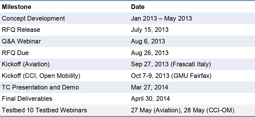
The OGC Testbed 10 was conducted according to the following key milestone schedule.
Table 1, OGC Testbed 10 Milestone Schedule
Milestone Date
Concept Development Jan 2013 – May 2013
RFQ Release July 15, 2013
Q&A Webinar Aug 6, 2013
RFQ Due Aug 26, 2013
Kickoff (Aviation) Sep 27, 2013 (Frascati Italy)
Kickoff (CCI, Open Mobility) Oct 7-9, 2013 (GMU Fairfax)
TC Presentation and Demo Mar 27, 2014
Final Deliverables April 30, 2014
Testbed 10 Testbed Webinars 27 May (Aviation), 28 May (CCI-OM)
OGC 14-044
Copyright © 2015 Open Geospatial Consortium. 9
The Statement of Work milestones defined various deliverables specific to each
participant. A number of ERs were completed beyond the Final Deliverables date. This was a result of inputs needed for the work not being available as anticipated. See ER table for more information.
6 Development Threads
Testbed 10 was organized around the following threads: 1) Aviation
2) Cross-Community Interoperability 3) Open Mobility
An introduction to each of these threads is provided. A list of ERs developed in each thread is also provided.
6.1 Aviation
The Aviation Thread focused on advancing the interoperable management and dissemination of aeronautical and flight information. To this end, the Aviation thread addressed the following main tasks:
Advance interoperable management of aeronautical and flight information
Test, validate and demonstrate the use of FIXM, AIXM, WXXM, and Digital NOTAM1 in a service-oriented architecture including Web Feature Service
(WFS), Web Coverage Service (WCS), and Event Service.
Develop recommendations for exchange of terrain data
Assess and investigate suitable formats and approaches for the interoperable exchange of terrain data that satisfy Aviation domain requirements.
Advance human factor based portrayal of Digital NOTAMs
Improve the way that aeronautical information, especially NOTAMs, is visualized.
Advance compliance
Advance the capability to test the conformance of geometry types contained in AIXM datasets and improve the documentation of the WFS extension to handle dynamic feature data.
Advance support of AIXM in development tools (J2EE, .NET)
Investigate and test ways to improve AIXM software development.
Sponsors: FAA, EUROCONTROL, NOAA NWS, Harris Corporation
Participants: 11 organizations
6.2 Key Accomplishments
The key accomplishments of the Aviation thread activities are:
Designed and implemented a GML 3.2 based encoding for FIXM 2.0 – a GML 3.2 Application Schema for FIXM 2.0 was developed and tested. This work is fundamental to serving FIXM data using an OGC WFS 2.0 compliant
implementation.
Developed application patterns for disseminating updates FIXM 2.0 features – Since FIXM 2.0 does not provide a temporal concept equivalent to the one defined for AIXM 5.1, an alternative approach for the publish/subscribe based dissemination of FIXM features was developed in order to enable the integration of FIXM data into the Aviation service architecture.
Integration of Weather Data – Access to NOAA’s weather data was made available using an OGC Web Coverage Service. For the first time within an OGC Testbed, the returned weather data were then integrated into the Aviation
scenarios. Backed by NOAA’s Web-gridded Document Service and encoded as WXXM, the WCS instance provided forecast weather data demonstrating new uses while applied in interesting use cases and scenarios.
Terrain Data Exchange – A set of recommendations on exchange formats to meet International Civil Aviation Organization (ICAO) Annex 15 and ADQ requirements; strategies to overcome cross-border differences in terrain data due to differences in national geodetic systems and provision of seamless terrain data; and demonstrated approaches to provide web-based access to eTOD data in an INSPIRE compliant way.
OGC 14-044
Copyright © 2015 Open Geospatial Consortium. 11
The following Engineering Reports were prepared to document the results in each of these task areas.
Table 2, Aviation Thread ERs
OGC Doc # Title
12-027r3 OGC Testbed 10 WFS Temporality Extension Discussion Paper Revision
14-000 OGC Testbed 10 GML for Aviation Conformance Testing ER
14-006 OGC Testbed 10 Aviation Recommendations for the Exchange of Terrain Data ER
14-007 OGC Testbed 10 Aviation Binding AIXM to Development Tools ER
14-008 OGC Testbed 10 Aviation Architecture ER
14-037 OGC Testbed 10 Aviation FIXM GML Schema ER
14-038r1 OGC Testbed 10 Aviation Dissemination of Weather Data ER
14-039 OGC Testbed 10 Aviation Human Factor Based Portrayal of Digital NOTAMs ER
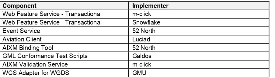
The following software components were developed, deployed and used to test and demonstrate the results achieved in this thread.
Table 3, Aviation Thread Software Components
Component Implementer
Web Feature Service - Transactional m-click
Web Feature Service - Transactional Snowflake
Event Service 52 North
Aviation Client Luciad
AIXM Binding Tool 52 North
GML Conformance Test Scripts Galdos
AIXM Validation Service m-click
WCS Adapter for WGDS GMU
6.3 Cross-Community Interoperability (CCI)
The Cross-Community Interoperability (CCI) thread was focused on tasks to build on interoperability within and between communities sharing geospatial data and to advance semantic mediation approaches for data discovery, access and use of heterogeneous data models and heterogeneous metadata models. The CCI Thread investigated the creation of domain ontologies and tools to create, assemble, and disseminate geographic data provided voluntarily by individuals. In addition, the CCI Thread demonstrated integration across all OGC web services with the intent to provide a better understanding of service content and the relationships or associations that exist between OGC services and resources/content. To this end, the thread addressed the following main tasks:
Volunteered Geographic Information (VGI) – The VGI effort continued on the work of Testbed 9 to expand the use of OGC services and standards for VGI access, data linking, and rule-based conflation based on results from attribute and spatial queries of gazetteer data.
Gazetteer - The Virtual Global Gazetteer effort extended the Single Point of Entry Global Gazetteer (SPEGG) work from Testbed 9, building on the framework established in that testbedand expanding gazetteer functionality to include gazetteer conflation and semantic gazetteer linking.
WPS conflation and provenance – Advanced data and service discovery. Investigated new and/or existing services using the benefit of semantic mediation approaches to support discovery of pertinent services or data collections.
Linked WPS and Decision Rules – Developed a framework for WPS to
investigate diverse data sets and build relational linkages and, when appropriate, invoke other services (e.g. WPS Conflation).
Profiles – Developed and tested implementations based on the latest versions of the Defence Geospatial Information Working Group (DGIWG) and the National System for Geospatial Intelligence (NSG) profiles of OGC Web Services.
Hydro Model Interoperability – Demonstrated interoperability among hydrographic and hydrologic data sources by linking model concepts across different hydrologic models to facilitate retrieval and delivery of data in a selected model format.
Sponsors: NGA, AGC, USGS, Natural Resources Canada (NRCan), UK DSTL, Lockheed Martin
Participants: 14 organizations
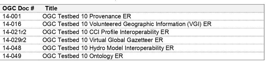
The following Engineering Reports were prepared to document the results in these task areas.
Table 4, CCI Thread ERs
OGC Doc # Title
14-001 OGC Testbed 10 Provenance ER
14-016 OGC Testbed 10 Volunteered Geographic Information (VGI) ER
14-021r2 OGC Testbed 10 CCI Profile Interoperability ER
14-029r2 OGC Testbed 10 Virtual Global Gazetteer ER
14-048 OGC Testbed 10 Hydro Model Interoperability ER
OGC 14-044
Copyright © 2015 Open Geospatial Consortium. 13
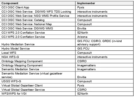
The following software components were developed, deployed and used to test and demonstrate the results achieved in this thread.
Table 5, CCI Thread Software Components
Component Implementer
CCI OGC Client App Pyxis
CCI OGC Web Service: DGIWG WFS TDS Locking interactive instruments
CCI OGC Web Service: NSG WMS Profile Service interactive instruments
CCI OGC Web Service: Catalog Compusult
CCI OGC Web Service: National Map Compusult
CCI OGC Web Service: DGIWG WMS Envitia
CCI WPS 2.0 Conflation Service 52North
CCI WPS 2.0 Conflation Service Arizona
Hydro Mediation Service
GIS.FCU; CSIRO, GRDC (in-kind advisory support)
Hydro Model Service GIS.FCU
Local WFS Compusult
NGA WFS-G interactive instruments
Ontology Mapping Component CSIRO
Ontology Mapping Component Imagematters
Semantic Mediation Service Imagematters
Semantic Mediation Service (virtual gazetteer
service) Envitia
USGS WFS-G Compusult
Virtual Global Gazetteer Client Pyxis
Virtual Global Gazetteer Service CSIRO
WFS/WPS for VGI 52North
6.4 Open Mobility
The Open Mobility thread explored geospatial standards requirements to implement mobile applications, information service concepts and Cloud computing. Client applications used in this testbed are mobile. Clients can also be found in enterprise desktop environments, workhorse tablets, or phone platforms. Data sets may be available via information services for mobile applications. They are distributed across clouds, internal servers and even individual users. And they consist of raw data and just-in-time processing capabilities. To this end, the thread addressed the following main tasks:
Cloud Computing: Exploitation and service performance enhancement
Mobile Data: OGC GeoPackages and GeoPackaging services
Linked OWS: Augmenting the OGC architecture to facilitate linking related data across services
Sponsors: NGA, ESA, and UK DSTL
Participants: 12 organizations.
The following Engineering Reports were prepared to document the results in these task areas.
Table 6, Open Mobility Thread ERs
OGC Doc # Title
14-002 OGC Testbed 10 OWS Context Annotations ER
14-009r1 OGC Testbed 10 OWS Context JSON Interoperability ER
14-013r1 OGC Testbed 10 Service Integration ER
14-017 OGC Testbed 10 OWS Context in NIEM ER
14-028r1 OGC Testbed 10 Performance of OGC Services in the Cloud ER
14-058r1 OGC Testbed 10 GeoPackaging ER
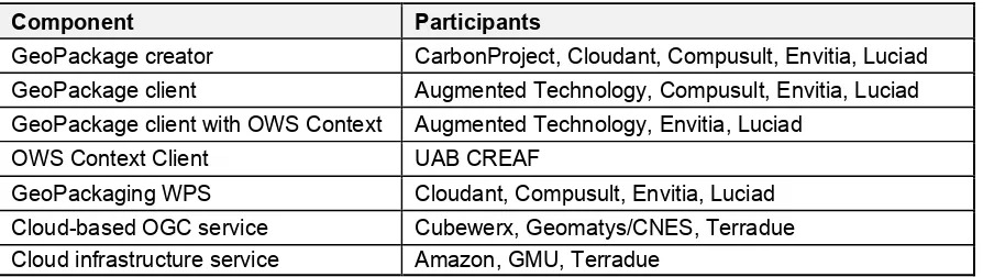
The following software components were developed, deployed and used to test and demonstrate the results achieved in this thread.
Table 7, Open Mobility Software Components
Component Participants
GeoPackage creator CarbonProject, Cloudant, Compusult, Envitia, Luciad
GeoPackage client Augmented Technology, Compusult, Envitia, Luciad
GeoPackage client with OWS Context Augmented Technology, Envitia, Luciad
OWS Context Client UAB CREAF
GeoPackaging WPS Cloudant, Compusult, Envitia, Luciad
Cloud-based OGC service Cubewerx, Geomatys/CNES, Terradue