QUALITY CONTROL OF ”DLG AND MAP” PRODUCT
Pei Wanga, JiYe Yub, LiBin Zhaoa, XinCheng Guob a
The First Institute of Photogrammetry and Remotes Sensing, Xi’an, China b
Chang’an University, Xi’an, China [email protected]
KEY WORDS:DLG and Map, quality control, the consistency of maps and DLG
ABSTRACT:
The product of ”DLGM” is a vector dataset of DLG and map, and is software independent, which is produced by our DLGM integrated technology system. This product has been included in the fundamental Geographic Information system (GIS), and confirmed by the mapping industry with its advantages of the integration, commonality, and multi-purpose. As a new kind product of digital map, it involves a large number of theoretical issues and technical problems. Specially, quality of product is a crucial problem in one of them. In our study, the basic framework of DLGM product is given firstly. And then we talk about quality control method and mechanisms in the production process, which involved dynamic modelling based on the topological map model, data dictionary and ”DLG and Map” integration template. The core task of this process is the consistency of maps and its corresponding geographic information. The rule of the process ensures the data quality in aspects of products design, manufacturing process method, tools, quality testing, application and data exchange. In recent years of practical application, a number of provincial fundamental DLGM products were produced by our DLGM integrated technology system, which has passed the existing quality standard authentication. It proved factually that the product quality control theory and technology which is adopted in our system is effective and feasible. At present, the technology and quality control method has been playing an important role in DLGM products.
1 INTRODUCTION
DLGM is a vector dataset of topographic map, which stores s-patial data, the relationship between ss-patial features; attributes of features, and feature’s map presentation data. We have studied the integration of GIS database and Map for many years, and gained lots of experience on its integrated manufacturing system at the same time. DLGM product is a reflection of our study achieve-ment. The integrated manufacturing system that mentioned above is the system to produce DLGM, which mainly contains the fol-lowing parts:
1.1 Topological map model
It is the physical model of DLGM product. In this model, a fea-ture (entity) consists of feafea-tures’ geometry, attributes, and the map presentation data. These three kind components have equal status in this topographic map model, which means there isn’t subordinate relationship between each component. This charac-ter makes the main difference between topological map model and the traditional map model, GIS model, and GIS portray pre-sentation model.
1.2 MapStore platform
MapStore, based on topographic map model, is the modelling software platform of DLGM. The platform can deal with the com-plicated spatial topology relationship of each feature, realize the dynamic modelling and processing produce qualified map prod-ucts also can maintain its integration of DLG and map data. Func-tions of this platform mainly are made up of model definition, data modelling and editing, quality inspection, data import and export.
1.3 The integration process
It is generally believed that the key of fundamental geographic information production (such as feature modelling, map editing) lies in building and keeping the topological relationship between
each feature. The integration process has put forward a series of methods (such as geometric construction method). In this way, DLGM product can be produced with higher quality and efficien-cy.
1.4 Quality control
Each link in the production system is a quality control unit. The links coordinate with each other. Quality check process is con-ducted according to the quality standards. These measures ensure that the DLGM product has complete quality control methods. For DLGM is a new digital map product, its basic theory and the technical method have attracted the attention of the whole indus-try. In this paper, the principle and method of DLGM quality control are detailed and discussed.
2 THE CONSISTENCY QUALITY CONTROL MECHANISMS OF DLGM
2.1 DLG -map integration model
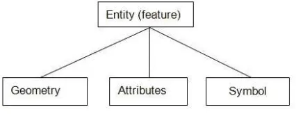
DLG-map integration model is the most essential mechanism that guarantees the consistency quality of DLGM product. The model is topological map model as we mentioned in charpter1. Figure 1 shows the structure of it.
A complete entity element consists of three child elements,
Figure 1: The structure of entity (feature)
International Archives of the Photogrammetry, Remote Sensing and Spatial Information Sciences, Volume XL-2/W1, 2013 8th International Symposium on Spatial Data Quality , 30 May - 1 June 2013, Hong Kong
which are feature’s geometry, the attribute information, and the feature’s map symbol data.The entity element and its child ele-ments form a tree relationship. Just as father node manage its child nodes, the entity element manage the feature’s geometry, attributes, and map symbol. The entity exits as long as one of the three child elements exits. If the entity has its three child elements and the three child elements can completely describe the geographic feature’s spatial information and attribute infor-mation, we consider the model is in healthy condition. However, for some reason, the entity is lack of child element or these child elements cannot express the real geographic feature, we say the model is morbid model. The healthy model and the morbid model can be mutual converted.
2.2 The child elements of entity
Geometry:Geometry element is the graphic expression of GIS. In the modelling process, geometry element expresses the real world by external manipulation.
Attribute:Attribute is the entity’s attribute information, such as feature name, the width of road, the value of elevation.
Symbol: Symbol is the entity’s map presentation data. During the modelling process, the initial generation of these map pre-sentation data is created by the geometry element and attribute element according to a certain rule (commonly known as symbol library). This initial process is also known as map symboliza-tion. However, in map presentation theory, only initial genera-tion is not enough, for the map symbolizagenera-tion data is just pre-liminary data. The map symbolization data needs additional pro-cessing operations to guarantee the correct relationship between each symbol. Only in this way, the symbols can be qualified pre-sented. The processing operation includes essential cartographic generalization and editing, etc.
2.3 The relationship between elements
The entity element manages its child elements. It is indirect cou-pling relationship among child elements. Entity element and its child elements can communicate with each other, which mean entity can receive, store, and deal with the information about its geometry, attributes, and map symbol. The information is mainly about the existence, position and attributes change of the child node. It’s quite necessary for the entity to receive the information of its children, as this information present whether the position of the symbol is reasonable, and whether the map symbol and the geometry are consistent. When necessary, we need do some quality consistency checking according to this information.
2.4 Element’s manipulation and information transfer
1.Manipulating entity, the child elements change accordingly. In the integration model, entity manages its child elements, so the change of entity will surely affect the children. When creating an entity, it means creating the geometry, attributes and symbol of the entity. Similarly, editing or deleting the entity element is editing or deleting its child elements.
2. Manipulating child element, it doesn’t affect its brother ele-ments. Geometry, attribute and symbol are siblings; there is no direct coupling relationship between brothers, which means that one of the child changes does not affect other child elements. The typical manipulation is editing the symbol, this operation does not affect the geometry and attribute element, but the editing in-formation will be passed to its parent, the entity will store the message about position change. This information provides basis for later inspection and quality control; In some cases, the geom-etry element is deleted, still this deleting operation does not affect
the existence of other brothers (in traditional model, the symbol relies on the geometry)we call this entity morbid entity, but it still has the existence and the entity stores the information that ge-ometry has been deleted. In the following inspection and quality control, we can make the entity turn to healthy status by adding its geometry and making some appropriate editing. 3. Manipulating the information stored in the entity. The entity is the information manager of the whole model. The entity has kept the information about the integrity and the change of the child elements. In exter-nal processing, we will judge the entity integrity, ratioexter-nally and taking a certain measures according to these information.
2.5 Brief summary
The structure of the integration model, relationship between each element, and the information flow pattern constitute the ”DLG and map” product’s consistency quality control mechanism.
3 THE QUALITY CONTROL DURING THEDLGM PROCESS
3.1 The manufacturing process of DLGM
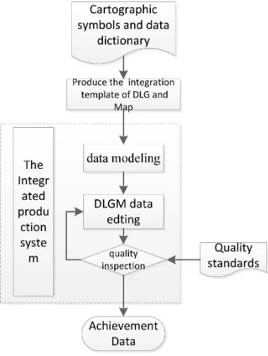
DLGM is produced in our integrated production system. We de-velop a production process through a large number of production-s. The flowchart is performed as following: The whole progress contains three steps: firstly, integrated template is made up based on the cartographic symbols and data dictionary; and then the object of DLGM is created based on the template automatical-ly. Finally, product of DLGM is generated after data editing and quality checking. Each step in the progress of DLGM producing is an unit of data quality essentially, they are very important in the quality control of DLGM. All the designed steps are essential to ensure the data quality of DLGM.
Figure 2: The flowchart of DLGM producing
3.2 Produce the integrated template of DLGM
At the beginning of DLGM production, integrated template is made up according strictly to the data dictionary and cartograph-ic symbols at first. For vector data, type of geometry, layer-s, attributes and symbols are defined in the template. For map
International Archives of the Photogrammetry, Remote Sensing and Spatial Information Sciences, Volume XL-2/W1, 2013 8th International Symposium on Spatial Data Quality , 30 May - 1 June 2013, Hong Kong
symbols are precisely defined according to cartographic symbol-s, including point-symbol, line-symbol, polygon-symbol, text-symbol and their colour, size, direction, the way of text-symbol gen-eration. This integrated template completely expresses the con-tent of data dictionary and cartographic symbols. In the process of data modelling, DLGM objects be created according to the template. Therefore, this guarantees the consistency of DLG and Map. Finally, at the process of quality inspection and analysis, the template can be used to as a standard.
3.3 Data modelling
The modelling of DLGM is a process of automatically transform-ing the raw data into DLGM objects accordtransform-ing the template in our integrated production system. A DLGM object is constructed by geometry, attribute and symbol. The symbol is created accord-ing to the geometry of DLGM, so which ensure the standards of symbol and maintain the consistent of DLG and Map.
3.4 Data editing
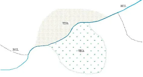
In the production of DLGM, with the reasons of the imperfect raw data, data changes and updates, and conflicted relationship among features, these will lead the necessary work of edition for DLGM objects which is created by template. This neces-sary works mainly contains such aspects in the following: data update, spatial topology, adding attribute, and symbol expression ect. In our study, a lot of novel processes are also designed to ensure the products’ quality of DLGM. In the spatial relationship of data editing process, often involves the public edges, which in tradition through copying features. In our integrated production system a new process —Geometric construction process was put forward. This process through construct complex lines based on the public line which was captured once. And a complex line was used in different layers. This method ensures the topological re-lations and eliminates gaps between the features, so the quality of vector data is guaranteed. As shown below, the public sides of BOUL HYDL TERA VEGA four layers were captured once. Then when the public side was changed, the four layers were changed at the same time.
Figure 3: Public side of features
3.5 Quality inspection
Quality inspection is an indispensable part of the data produc-tion process. There will be some inevitable errors in the pro-cess of data producing, such as ill-model, unreasonable geome-try, conflicted topology relationship and so on. For problems of quality in DLGM, we conducted a lot of research on the process of production and provided specialized quality control methods
and processing tools to ensure that the quality according to the characteristics of DLGM products. Due to the information about geometry, attribute and symbol are all stored in the DLGM ob-ject, these information can be used to check consistency of DLG and Map. Besides, the methods for checking the inconsistency of feature and corresponding symbol, the inconsistency of label and attribute are provided.
In our production system, we inspect DLGM product according to the quality control specifications. Expect for common methods for checking quality of conventional vector data, we also provide the method for checking map.
4 CONCLUSION
DLGM is an integration product of GIS data and vector map da-ta. The quality of this product is an important factor in produc-tion process. In our integraproduc-tion producproduc-tion system, the topologi-cal map model, which is the basis of DLGM products, adapts to data modelling and editing. Mapstore is the productions platfor-m; the integrated template is an important guarantee of quality. Our process method produce the qualified data, at the same time maintain the spatial relationships between data rationality. With the constant improvement of the DLGM product’s quality control system, the products will also be more perfect.
5 ACKNOWLEDGEMENTS
We would like to thank the reviewers’ and editor’s valuable com-ments.
REFERENCES
Chang, K.-t., 2010. Introduction to geographic information sys-tems. McGraw-Hill New York.
Hu, J.-S. and Kang, J.-R., 2005. Error analyzing and quality con-trol to map scanning digitization. Science of Surveying and Map-ping 30(2), pp. 90–91.
Vickers, D. and Mahrt, R., 1997. Quality control and flux sam-pling problems for tower and aircraft data. Journal of Atmospher-ic and OceanAtmospher-ic Technology 14(3), pp. 512–526.
Wenzhong Shi, e. a., 2004. Spatial data quality. CRC Press, pp. 85–95.
Wu, W. and Guo, X., 2011. 2011.An Introduction to Nation-al FundamentNation-al Geographic Information DigitNation-al Product-DigitNation-al Line Graphs and Map. Bulletin of Surveying and Mapping p-p. 61–63.
International Archives of the Photogrammetry, Remote Sensing and Spatial Information Sciences, Volume XL-2/W1, 2013 8th International Symposium on Spatial Data Quality , 30 May - 1 June 2013, Hong Kong