Copyright © 2009 Open Geospatial Consortium, Inc. 1
Open Geospatial Consortium Inc.
Date:2009-04-08Reference number of this document:OGC 09-018
Version: 0.2.2
Category: OpenGIS® Discussion Paper
Editors:Ben Domenico and Stefano Nativi
Web Coverage Service (WCS) 1.1 extension for CF-netCDF 3.0
encoding
Copyright © 2009 Open Geospatial Consortium, Inc.
To obtain additional rights of use, visit http://www.opengeospatial.org/legal/.
Warning
This document is not an OGC Standard. This document is an OGC Discussion Paper and is therefore not an official position of the OGC membership. It is distributed for review and comment. It is subject to change without notice and may not be referred to as an OGC Standard. Further, an OGC Discussion Paper should not be referenced as required or mandatory technology in procurements.
Document type: OpenGIS® Discussion Paper
Document subtype: Extension
Document stage: Draft proposed version 0.2.2
Copyright © 2009 Open Geospatial Consortium 2
Copyright © 2009 Open Geospatial Consortium 3
Contents
Page Preface 6 Document terms and definitions ...6Document contributor contact points ...7
Revision history ...7
Changes to the OGC Abstract Specification ...7
Future work ...8
Foreword ...9
Introduction ...10
1 Scope ...10
2 WCS CF-netCDF3 encoding extension Standard overview ...10
3 Summary of WCS Extensions ...11
4 Content and organization ...12
5 Overview of netCDF and CF conventions (Section B) ...12
5.1 NetCDF ...12
5.1.1 NetCDF-3 Data Model ...13
5.1.2 NetCDF Coordinate Variables ...13
5.1.3 NetCDF Standard Attribute Conventions ...14
5.1.4 NetCDF-3 Binary File Format ...14
5.1.5 NcML ...15
5.1.6 NetCDF Documenation ...15
5.2 CF Conventions ...16
5.2.1 CF Standard names ...17
5.2.2 CF Units ...18
5.2.3 CF Coordinate types and coordinate systems ...18
5.2.4 CF Grid Cells ...19
6 Code for Implementing the netCDF Interface (Section E) ...20
7 Support ...21
8 NetCDF Examples (Section D) ...21
9 Compliance (Section F) ...21
10 OPeNDAP ...21
11 CF-netCDF Mapping to WCS Data Model (Normative) (Section C) ...23
11.1 NetCDF grid data mapping to ISO Discrete Grid Point Coverage type ...23
11.1.1 NetCDF Discrete Vs Continuous Coverage types ...24
Copyright © 2009 Open Geospatial Consortium 4
11.2.1 General aproach ...25
11.2.2 Formal approach ...25
11.2.3 CF-netCDF grid data profile model ...26
11.2.4 ISO DiscreteGridPointCoverage profile model ...27
11.2.5 Mapping Rules (Normative) ...28
12 Limitations and future work...32
13 References ...33
Annex A: Details of CF-netCDF describeCoverage response (Normative) ...35
A.1 Domain of coverage data structure ...36
A.2 Range data structure ...36
A.3 Field data structure ...36
Annex B: Details of CF-netCDF getCoverage response (Normative)...38
B.1 General GetCoverage response for CF-netCDF data ...38
B.1.1 GetCoverageResponse ...40
B.1.2 OutputCoverage ...40
B.1.3 GridCoverageValues ...41
B.1.4 Manifest (Coverages data structure) ...41
B.1.5 RequiredOutputCoverageMetadata ...42
B.1.6 GridCoverageFile ...43
B.1.7 GridCoverageValuesURI association ...43
B.1.8 CF-netCDF file ...44
B.1.9 NcMLDataset ...44
B.1.10 OPeNDAP-URL ...44
B.2 Content model of the WCS complete GetCoverage response for CF-netCDF3 binary file ...44
Figure 8 - Data bundle structure transferred by a general WCS complete GetCoverage response returning a CF-netCDF3 binary file ...45
B.3 Complete GetCoverage response for ncML document ...46
B.5 Partial GetCoverage response ...48
B.6 WCS GetCoverage response: Multipart data encoding ...48
B.6.1 Case #1 SOAP with binary data ...49
B.6.2 Case #2 HTTP Response with binary data ...51
B.6.3 Case #3 and #4: SOAP or HTTP Response with NcML data ...53
B.6.5 Content-ID generation ...59
B.6.6 Proposed extensions for handling ncML Responses ...60
Appendix C: Examples ...62
C.1 Example: netCDF 3 with CF1.1 convention dataset ...62
C.2 Example for a ncML dataset ...63
C.3 GetCoverage response encoding examples ...65
C.3.1 SOAP Request of two netCDF data items and metadata ...65
C.3.2 HTTP Request of two netCDF data items and metadata ...66
C.3.3 SOAP Response with binary and ncML data ...68
Copyright © 2009 Open Geospatial Consortium 5
C.3.5 Multipart section containing ncML with binary data extracted using XOP ...71
Appendix D: Compliance Testing ...74
Figures
Page Figure 1 - NetCDF3 data model 13 Figure 2 - CF-netCDF data model 17 Figure 3. The general strategy followed for the CF-netCDF mapping to WCS Data Model 23 Figure 4 - CF-netCDF profile model 27 Figure 5 - ISO DiscreteGridPointCoverage profile model 27 Figure 6 - Mapping Schema 28 Figure 7 - Abstract model of general WCS GetCoverage response for CF-netCDF data. Yellow objects are encoded as XML documents; red objects are encoded as binary files/sections; gray objects are abstract. 40 Figure 8 - Data bundle structure transferred by a general WCS complete GetCoverage response returning a CF-netCDF3 binary file 45 Figure 9 - Data bundle structure transferred by a general WCS complete GetCoverage response returning a ncML/CF-netCDF document 47Tables
Page Table 1. Summary of relationship between the CF-netCDF and the DiscreteGridPointCoverage profile models: main packages ... 28Table 2. Summary of relationship between the CF-netCDF and the DiscreteGridPointCoverage profile models: Dataset package ... 29
Table 3. Summary of relationship between the CF-netCDF and the DiscreteGridPointCoverage profile models: Coordinate System package ... 30
Table 4. Manifest data structure [OGC 06-121r3: Table 45] ... 41
Table 5. Required output coverage metadata [OGC 07-067r5] ... 42
Copyright © 2009 Open Geospatial Consortium 6
Preface
This Discussion Paper describes a draft standard is an extension of the Web Coverage Service (WCS) version 1.1.2 Implementation Standard [OGC 07-067r5]. With small changes, this extension is expected to also apply to WCS 1.2.0. Unlike previous versions, WCS 1.1 and 1.2 are divided into a base standard plus multiple extensions (formerly called application profiles).
Suggested additions, changes, and comments on this draft standard are welcome and encouraged. Such suggestions may be submitted by email message or by making suggested changes in an edited copy of this document.
Document terms and definitions
This document uses the standard terms defined in Subclause 5.3 of [OGC 06-121r3], which is based on the ISO/IEC Directives, Part 2. Rules for the structure and drafting of International Standards. In particular, the word ―shall‖ (not ―must‖) is the verb form used to indicate a requirement to be strictly followed to conform to this standard.
Data Model: a data model is a way of thinking about scientific data by applying a data model theory. It is an abstraction that describes how datasets are represented and used. In computer terms, a data model can be thought of as equivalent to an abstract object model in Object Oriented Programming in that an abstract data model describes data objects and what methods can be used on them.
NetCDF-CF: netCDF-CF is a standard for data on complex grids –curvilinear in XY; sigma and density-related in Z; climatological and artificial calendars in T; and heading towards "tile mosaics" and 5D forecast ensembles in the near future.
Copyright © 2009 Open Geospatial Consortium 7
Document contributor contact points
All questions regarding this document should be directed to the editor or the contributors:
Name Organization
Ben Domenico UCAR/Unidata [email protected] Stefano Nativi CNR/IMAA
[email protected] Ethan Davis UCAR/Unidata
Dominic Lowe British Atmospheric Data Centre [email protected]
Paolo Mazzetti CNR/IMAA
Revision history
Date Release Editor Primary clauses modified
Revision and integration of comments. NetCDF-CF example
Document revision. Encoding examples
04 January 2009
2.1 Stefano Nativi
OPeNDAP encoding is added 08 April
2009
2.2 Carl Reed Stefano Nativi
Various Edits required prior to posting as a DP.
Changes to the OGC Abstract Specification
Copyright © 2009 Open Geospatial Consortium 8
Future work
Improvements in this document are desirable to support changes and additions to CF-netCDF encoding. However, it is important that WCS and CF-netCDF remain ―loosely coupled‖ in the sense that each can change and evolve without having to rewrite the other each time.
In particular, this extension standard encoding profile is limited to regular and warped grids as specified by the current WCS 1.1, but irregular grids are important in the CF-netCDF community and work is underway to expand the CF-CF-netCDF to encompass non-gridded datasets. The current plan is to include these augmentations in subsequent versions of this standard extension.
Copyright © 2009 Open Geospatial Consortium 9
Foreword
This document is an extension of the Web Coverage Service (WCS) version 1.1.2 Implementation Standard [OGC 07-067r5] for the CF-natCDF 3 encoding. With small changes, this extension is expected to also apply to WCS version 1.2. Needed changes for subsequent WCS releases can be incorporated by editing Annex B or by adding another Annex that provides the equivalent information for the latest WCS release. This
extension is based on change request [OGC-06-043r4], and supersedes that Discussion Paper. This document does not supersede any other previously approved OGC document
Attention is drawn to the possibility that some of the elements of this document may be the subject of patent rights. The Open Geospatial Consortium Inc. shall not be held responsible for identifying any or all such patent rights.
Copyright © 2009 Open Geospatial Consortium 10
Introduction
The Web Coverage Service (WCS) supports electronic retrieval of geospatial data as "coverages" – that is, digital geospatial information representing space-varying phenomena. A WCS provides client access to potentially detailed and rich sets of geospatial information in forms that are useful for client-side rendering, multi-valued coverages, and input into scientific models and other clients. The WCS is currently limited to quadrilateral grid coverages, providing information at the grid points, usually with interpolation between these grid points.
This extension of the WCS standard specifies a CF-netCDF3 encoding format option. This is based on the netCDF (network Common Data Form) ver. 3.0 file format using the CF (Climate and Forecast) conventions ver. 1.1
Web Coverage Service (WCS) 1.1 extension for CF-netCDF 3.0
encoding
1 Scope
This extension of the WCS standard specifies an Information Community data model with the related encoding that may optionally be implemented by WCS servers. This extension specification allows clients to evaluate, request and use data encoded in CF-netCDF3 format from a WCS server.
This document is an extension of the Web Coverage Service (WCS) 1.1 Corrigendum 2 (version 1.1.2) Implementation Standard [OGC 07-067r5]. With small changes, this extension is expected to also apply to WCS 1.2.
2 WCS CF-netCDF3 encoding extension Standard overview
This extension Standard specifies a CF-netCDF3 data model with the related binary and XML-based encoding formats in which data may be requested by a WCS client and provided by a WCS server. This extension Standard is an optional implementation by servers. The format is netCDF conforming to the Climate and Forecast (CF)
Copyright © 2009 Open Geospatial Consortium 11
NetCDF is a widely-used set of interfaces for array-oriented data access and a freely-distributed collection of data access libraries for C, Fortran, C++, Java, and other languages. The netCDF libraries support a machine-independent, self-documenting binary format for representing scientific data. Together, the interfaces, libraries, and format support the creation, access, and sharing of scientific data. The CF conventions define metadata (internal to a netCDF file) that provide a definitive description of what the data in each variable represents, and of the spatial and temporal properties of the data.. This enables the users of data from different sources to decide which quantities are comparable and how they relate to one another in space and time.The perceived need for a WCS 1.1. standard extension for CF-netCDF3 arose from the experiences of the OGC GALEON (Geo-interface for Air Land Environment Ocean Netcdf) Interoperability Experiment. In this experiment, several WCS 1.0 clients were successful in accessing data from WCS 1.0 servers which encoded the data in CF-compliant netCDF (version 3.0) form. The GALEON experiment has proven that the CF-netCDF3 is a viable and valuable WCS encoding format. However, CF-netCDF3 was not among the list of 5 ―required supported formats‖ in the WCS 1.0 specification.
Based on the OGC GALEON experiment and subsequent discussion in the WCS
Revision Working Group (RWG) and subsequent Standards Working Group (SWG), this proposal in conjunction with the later WCS 1.x specifications will establish CF-netCDF3 as a WCS ―supported output format.‖
3 Summary of WCS Extensions
This extension specifies the following set of modifications to WCS operations:
GetCapabilities and DescribeCoverage for CF-netCDF3 datsets o Mapping of CF-netCDF3 data model onto WCS 1.1.2
o Introduction of a new MIME type: application/x-netcdf. GetCoverage for CF-netCDF datsets
o Specification of the abstract data model of the WCS GetCoverage response for CF-netCDF datasets.
o Specification of the content model of the WCS GetCoverage response for the following CF-netCDF datasets encodings:
Local binary file format
Remote binary file format using OPeNDAP ncML (netCDF Markup Language)
Copyright © 2009 Open Geospatial Consortium 12
4 Content and organization
It is important to note that this document does not contain inline a specification of the netCDF file format or application programming interface. Nor does it contain inline a specification of the CF conventions. The underlying assumption is that parties interested in working with coverages encoded in CF-netCDF3 will do so using existing libraries rather than coding from scratch to the existing specifications, so one goal of this document is to point them to the documentation, code, and related materials they will need to do so.
Hence, this document includes the encoding profile information specified in Section 9.3.2.2 of WCS 1.1 (07-067r2), namely:
a) MIME type(s) and brief description: a concise overview of the encoding format, including the MIME type string(s) used to refer to it, the files required (e.g. header, dictionary, georeferencing, etc.), and the ―role‖ values in the Xlink references in the GetCoverage response (see Subclauses 10.3.11.2 and I.3.2).
b) Pointers to documentation for the encoding format. This documentation shall clarify how the encoding convention represents locations, times, and physical quantities represented in the dataset.
c) Data model mapping to the ISO 19123: Coverage Abstract Specification. This includes conventions for representing the spatio-temporal domain, and for representing the dimensions in the range. It also describes limitations of the format for encoding complex coverages, and limitations of the coverage model for representing complex data structures encoded in the format.
d) Examples: A set of examples of the encoding format, and of corresponding Coverages XML response documents (see Appendix C).
e) Pointers to implementing software for the encoding format. Providers of this software may license it in source code or executable form.
f) Compliance Testing: Pointers to mechanisms for testing whether resulting WCS coverages conform to the encoding format (see Appendix D).
5 Overview of netCDF and CF conventions (Section B)
5.1 NetCDF
NetCDF (network Common Data Form) is an interface for array-oriented data access and a library that provides an implementation of the interface. The netCDF library also defines a machine-independent format for representing scientific data. Together, the interface, library, and format support the creation, access, and sharing of scientific data.
Copyright © 2009 Open Geospatial Consortium 13
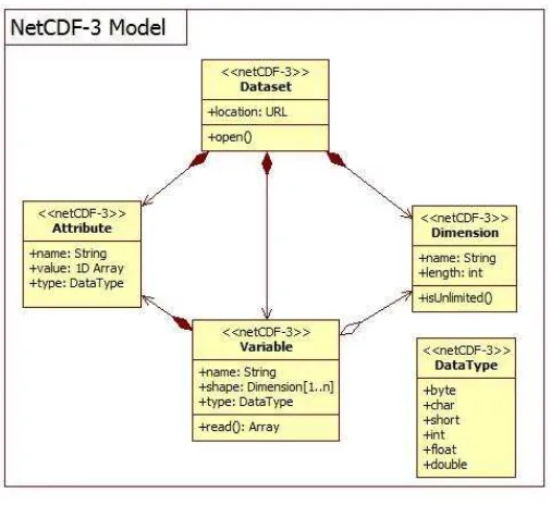
5.1.1 NetCDF-3 Data Model
The netCDF-3 data model is a simple one made up of four basic pieces: datasets, variables, dimensions, and attributes. The dataset or file itself can contain variables, dimensions, and attributes. Each variable is an n-dimensional array of one of the
following types: byte, char, short, int, float, and double. The dimensions are named and are used to define the shape of the variables. Attributes are name/value pairs that can be contained at the dataset or variable level.
The fact that dimensions are named and scoped to the entire dataset is significant in that if the same dimension is used in multiple variables it means that those variables are related in that dimension.
The netCDF3 data model using UML is depicted in Figure 1.
Figure 1 - NetCDF3 data model
5.1.2 NetCDF Coordinate Variables
Copyright © 2009 Open Geospatial Consortium 14
netcdf temperature {
dimensions:
5.1.3 NetCDF Standard Attribute Conventions
The [NUG] Appendix B ―Attribute Conventions‖ defines a convention for a number of standard attributes. The convention includes attributes to specify the units of a variable, the minimum and maximum allowed values for a variable, a value to be considered ―missing data‖, scale/offset values, as well as the conventions used in the dataset. Adding some of these conventions to the above example gives us:
netcdf temperature { dimensions:
temperature:long_name=”temperature”;
temperature:units=”K”;
}
5.1.4 NetCDF-3 Binary File Format
From the ―NetCDF Users Guide‖ [NUG] section 4 ―File Structure and Performance‖,
A netCDF classic or 64-bit offset dataset is stored as a single file comprising two parts:
Copyright © 2009 Open Geospatial Consortium 15
2. a data part, comprising fixed-size data, containing the data for variables that don't have an unlimited dimension; and variable-size data, containing the data for variables that have an unlimited dimension.
Both the header and data parts are represented in a machine-independent form. This form is very similar to XDR (eXternal Data Representation), extended to support efficient storage of arrays of non-byte data.
More detailed information is available in the ―File Format Specification‖ [NUG, appendix C].
5.1.4.1 MIME type (Normative) (Section A) [Clause] MIME type string used to refer to it:
Note that the only MIME type in use presently is ―application/x-netcdf‖ and it is not officially registered. Thus the MIME types discussed below are new and application for registration will be made to IANA.
binaryapplication/CF-netCDF3
5.1.5 NcML
[Clause] MIME type string used to refer to it:
application/ncML+ xml
This xml media type is unregistered.
5.1.6 NetCDF Documenation
The netCDF home page is located at Unidata:
http://www.unidata.ucar.edu/software/netcdf/
A list of netCDF documents is available at:
http://www.unidata.ucar.edu/software/netcdf/docs/
There is a netCDF Users Guide at:
Copyright © 2009 Open Geospatial Consortium 16
The UNIDATA documentation also provides the File Format Specification
http://www.unidata.ucar.edu/packages/netcdf/guide_15.html
for netCDF and Best Practice recommendations on writing netCDF files
http://www.unidata.ucar.edu/packages/netcdf/BestPractices.html
The netCDF XML encoding (ncML) is documented at:
http://www.unidata.ucar.edu/software/netcdf/ncml/
http://www.unidata.ucar.edu/projects/THREDDS/BenStuff/Documents/WCSnetCDF. htm
http://linkinghub.elsevier.com/retrieve/pii/S0098300405001019
http://www.unidata.ucar.edu/software/netcdf/ncml/v2.2/AnnotatedSchema.html
5.2 CF Conventions
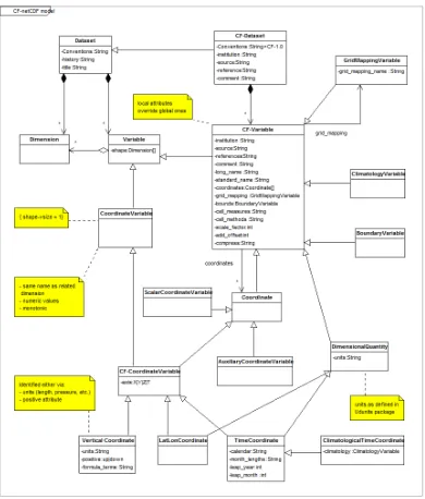
The CF conventions define metadata that provide a definitive description of what the data in each variable represents, and of the spatial and temporal properties of the data. This enables users of data from different sources to decide which quantities are comparable, and facilitates building applications with powerful extraction, regridding, and display capabilities.
To identify that the file uses the CF convention, it recommends the Conventions attribute be given the
string value of ―CF-1.1‖.
The CF Conventions home page is located at PCMDI:
http://cf-pcmdi.llnl.gov/
Copyright © 2009 Open Geospatial Consortium 17
Figure 2 - CF-netCDF data model
5.2.1 CF Standard names
What do the numbers in a netCDF dataset represent? e.g., temperature, pressure, wind speed, salinity, radiance, reflectivity.
Since netCDF variable names are not always enough to fully describe the physical quantity being represented, the CF convention provides an optional variable attribute, standard_name, for associating the variable with a standard name. The CF
Copyright © 2009 Open Geospatial Consortium 18
Description of CF standard names conventions:
http://cf-pcmdi.llnl.gov/documents/cf-conventions/1.1/ch03s03.html
Table of CF Standard names:
http://cf-pcmdi.llnl.gov/documents/cf-standard-names/7/cf-standard-name-table.html
5.2.2 CF Units
What are the units of measure for the numbers in a netCDF dataset?
The CF convention requires the units attribute for all variables that represent dimensional quantities. The value of the units attribute must be a string that can be recognized by
Unidata’s Udunits software package [UDUNITS]. More information on theunits
attribute can be found in Section 3.1 ―Units‖ of the CF convention specification [CF].
Description of CF units of measure:
http://cf-pcmdi.llnl.gov/documents/cf-conventions/1.1/ch03.html#units
5.2.3 CF Coordinate types and coordinate systems
Where in space do the numbers represent measurements or modeled values?
The CF convention gives special treatment to latitude, longitude, vertical, and time coordinates. ―Chapter 4
Coordinate Types‖ of the CF specification [CF] details how coordinates are identified for these special
coordinate types.
―Chapter 5 Coordinate Systems‖ [CF] explains two methods by which coordinate variables are associated
with individual variables to form the coordinate system for that variable. The first method is the same as the netCDF coordinate variable convention defined in the [NUG].
For horizontal coordinates that are not latitude/longitude, section 5.6 ―Grid Mappings and Projections‖
describes how various projections and mappings can be specified. For instance, the following is the previous example in a Transverse Mercator projection:
netcdf temperature { dimensions:
x = 45; y = 57;
variables:
double lat(y, x);
lat:long_name = ”latitude”;
lat:units = ”degrees_north”;
double lon(y, x);
Copyright © 2009 Open Geospatial Consortium 19
lon:units = ”degrees_east”;
double temperature(y, x);
temperature:long_name = ”temperature”;
temperature:units = ”K”;
temperature:coordinates = “lat lon”;
temperature:grid_mapping = “tm_mapping”;
int tm_mapping;
tm_mapping:long_name = “British National Grid / OSGB 1936”;
tm_mapping:grid_mapping_name = “transverse_mercator”;
tm_mapping:semi_major_axis = 6377563.396; tm_mapping:inverse_flattening = 299.3249646; tm_mapping:latitude_of_projection_origin = 49.0; tm_mapping:longitude_of_projection_origin = -2.0; tm_mapping:false_easting = 400000.0;
tm_mapping:false_northing = -100000.0; tm_mapping:scale_factor_at_projection_origin = 0.9996012717; }
Coordinate types description:
http://cf-pcmdi.llnl.gov/documents/cf-conventions/1.1/ch04.html
Coordinate systems description:
http://cf-pcmdi.llnl.gov/documents/cf-conventions/1.1/ch05.html
5.2.4 CF Grid Cells
The CF convention defines a number of methods for defining the extent of the grid cells in ―Chapter 7 Data
Representative of Cells‖ [CF]. For instance, a bounds attribute can be added to appropriate coordinate variables. The bounds value is the name of the variable containing the vertices of the cell boundaries.
Copyright © 2009 Open Geospatial Consortium 20
double lon_bnds(lon, nv);
Grid mappings description:
http://cf-pcmdi.llnl.gov/documents/cf-conventions/1.1/ch05s06.html
5.2.4.1.1 CF Time coordinate
When were the measurements taken or modeled values forecast?
The CF convention defines a mechanism for specifying information about time and calendars including support for concepts such as 360-day calendars which are used in climate modeling.
Time coordinate description:
http://cf-pcmdi.llnl.gov/documents/cf-conventions/1.1/ch04s04.html
6 Code for Implementing the netCDF Interface (Section E)
The vast majority of netCDF users use the same set of supported netCDF libraries to implement their systems. Consequently anyone intending to access data in netCDF form via the WCS interface should consider using this code which can be downloaded at:
http://www.unidata.ucar.edu/software/netcdf/
Implementations are available in several programming languages: Installation instructions for C, Fortran, and C++ libraries NetCDF for Java
Other interfaces to netCDF data:
o MATLAB:
http://www.unidata.ucar.edu/software/netcdf/software.html#MATLAB
o Objective-C:
http://www.unidata.ucar.edu/software/netcdf/software.html#Objective-C
o Perl: http://www.unidata.ucar.edu/software/netcdf/software.html#Perl
o Python:
http://www.unidata.ucar.edu/software/netcdf/software.html#Python
o R: http://www.unidata.ucar.edu/software/netcdf/software.html#R
o Ruby: http://www.unidata.ucar.edu/software/netcdf/software.html#Ruby
o Tcl/Tk:
Copyright © 2009 Open Geospatial Consortium 21
7 Support
Potential users of netCDF may be interested in what support is available for the code and interface. Pointers to netCDF FAQ, mailing lists, documentation are available at:
http://www.unidata.ucar.edu/software/netcdf/
8 NetCDF Examples (Section D)
A set of representative examples of netCDF datasets is essential for gaining an understanding. A good place to start is:
http://www.unidata.ucar.edu/software/netcdf/examples/files.html
http://mst.nerc.ac.uk/file_format_netcdf.html
http://badc.nerc.ac.uk/help/formats/netcdf/index_cf.html
9 Compliance (Section F)
Ensuring adherence to WCS is an issue separate from the CF-netCDF encoding. Several documents are available with recommendations for CF-netCDF verification. They are listed in
CF Requirements and Recommendations
http://cf-pcmdi.llnl.gov/conformance/requirements-and-recommendations/
In order to test whether the netCDF encoded file transferred via a WCS getCoverage request complies with CF conventions, a CF conventions compliance test is available at:
CF-netCDF Compliance:
http://badc.nerc.ac.uk/help/formats/netcdf/index_cf.html
10 OPeNDAP
OPeNDAP (Open-source Project for a Network Data Access Protocol)1 provides software which makes local data accessible to remote locations regardless of local storage format. OPeNDAP software is freely available.
NetCDF Community applications commonly make use of the OPeNDAP approach to access remote, time-aggregated collections of netCDF-CF files (virtual datasets – often terabyte sized) through the unaltered netCDF API –as if they were local netCDF files.
For the scope of this document, a simplified view of OPeNDAP is that it is a transparent mechanism by which an application can use netCDF API calls on a remote file. Thus for
Copyright © 2009 Open Geospatial Consortium 22
any netCDF subset that may be derived from a WCS server, there may be an OPeNDAP URL that is an indirect reference to that same subset.
For example let us consider the dataset coads_climatology.nc, served by the WCS server implemented by the TDS (THREDDS Data Server) at
http://ferret.pmel.noaa.gov/thredds/dodsC/data/PMEL/coads_climatology.nc.html.
The dataset contains 12 months of grids for seven different surface met fields. Imagine a WCS GetCoverage request that would return a netCDF file containing global SST for the month of January. The contents of this exact netCDF subset can be expressed by the OPeNDAP URL:
"http://ferret.pmel.noaa.gov/thredds/dodsC/data/PMEL/coads_climatology.nc?COADSX, COADSY,TIME[0:1:0],SST[0:1:0]".
Copyright © 2009 Open Geospatial Consortium 23
11 CF-netCDF Mapping to WCS Data Model (Normative) (Section C)
For use in the context of WCS, it is important to have an understanding of the mapping between the data models used for OGC coverages and those for the netCDF with CF conventions. What follows is a conceptual overview section for background followed by a more formal and detailed section with UML diagrams comparing the two data models.
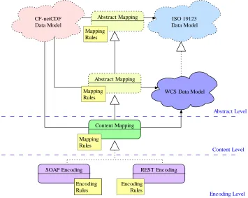
The general mapping strategy is depicted in Figure 3
CF-netCDF
SOAP Encoding REST Encoding
Encoding
Figure 3. The general strategy followed for the CF-netCDF mapping to WCS Data Model
11.1 NetCDF grid data mapping to ISO Discrete Grid Point Coverage type Grid is defined as a network composed of two or more sets of curves in which the
members of each set intersect the members of the other sets in an algorithmic way. These curves partition a space into grid cells. The axes of the grid provide a basis for defining grid coordinates. The axes need to be identified to support sequencing rules for
Copyright © 2009 Open Geospatial Consortium 24
point objects characterizing the grid tessellation. The domain of a Discrete Grid Point Coverage instance is a set of Grid Points that are associated with records of feature attribute values through a CV_GridValuesMatrix element.
Therefore, netCDF grid data type must be mapped onto the ISO 19123 CV_DiscreteGridPointCoverage type.
11.1.1 NetCDF Discrete Vs Continuous Coverage types
In most cases, a continuous coverage is also associated with a discrete coverage that provides a set of control values to be used as a basis for evaluating the continuous coverage. Evaluation of the continuous coverage at other direct positions is done by interpolating between the geometry value pairs of the control set. This often depends upon additional geometric objects constructed from those in the control set; these
additional objects are typically of higher topological dimension than the control objects.
In ISO 19123, such objects are called ―geometry value objects‖. A geometry value object is a geometric object associated with a set of geometry value pairs that provide the control for constructing the geometric object and for evaluating the coverage at direct positions within the geometric object.
A common example of geometry value object is represented by quadrilateral grid cell whose vertices are represented by four grid points (i.e. the set of geometry value pairs).
In the netCDF domain, the continuous quadrilateral grid coverage type is associated to a discrete grid point coverage type by sharing the same geometry grid and matrix values; the two coverage subclasses share the GridValueMatrix object and the derived
GridPointValuePair objects. The real difference consists in the realization of the locate() operation, which is inherited from the Coverage super-type. Therefore, ―the principal use of discrete point coverages is to provide a basis for continuous coverage functions, where the evaluation of the continuous coverage function is accomplished by interpolation between the points of the discrete point coverage‖.
In the case of netCDF data, the interpolation methods specified by the ISO continuous coverage classes do not apply in general. In fact, in most cases, any scientifically realistic interpolation depends on the physics of the situation as well as the geometry. Hence, any realistic interpolation is actually data dependent.
Copyright © 2009 Open Geospatial Consortium 25
11.2 The Mapping approach 11.2.1 General aproach
Any group of CF-netCDF data variables that share the same set of spatial/temporal coordinate variables can be mapped to a single grid coverage,
CV_DescreteGridPointCoverage.
The set of spatial/temporal coordinate variables maps to the domain of the coverage, whose geometry is represented by a single grid, CV_Grid. The grid mapping and/or projection information maps to the CRS and the associated CoordinateSystem (e.g. the units of the coordinate system).
The data variables in the CF-netCDF coverage make up the range with each variable being a separate range field.
Since the coordinate variables do not define the location of the data points with an origin and offset vectors but rather provide a lookup table of sorts, a CF-netCDF coverage can be more closely modeled with a CV_ReferencableGrid than with a CV_RectifiedGrid. However, when the associated coordinate variables are evenly spaced a CF-netCDF coverage can be modeled as a CV_RectifiedGrid. The CF grid cell methods map to CV_GridCell.
11.2.2 Formal approach
To explicitly map the CF-netCDF grid data model (e.g. FES hyperspatial observation and model outputs) to the ISO Coverage data model (i.e. CV_DiscreteGridPointCoverage type), there is a need to address structural and semantics differences, applying the appropriate constraints and, hence, performing a mediation process.
Points to consider include:
CF-netCDF grid data model supports datasets characterized by multiple domains (e.g. more than one coordinate system is defined for a dataset), whereas an ISO coverage is characterized by a single coordinate system.
CF-netCDF grid data model supports datasets characterized by arbitrary multi-dimensional domains, whereas an ISO coverage domain is either 2-D (space), 3-D (2D + vertical dimension or 2D + time), 4-D (2D + vertical dimension + time).
Most commonly, the grid axes of a CF-netCDF dataset coincide with reference system axes. However, CF-netCDF allows arbitrary domain shapes, i.e. grid axes ordering. Thus, it is possible to have a variable v1 defined on a grid <x, y, t, z> and a variable v2 defined on a grid <z, x, t, y>. Since there is a fixed enumeration of allowed compound CRSs in ISO coverages, the transformation of such
Copyright © 2009 Open Geospatial Consortium 26
transformation. In other words, mapping CDM grids to ISO (geo)rectified grids may require axes reshaping and reordering.
There are two main steps to address these mediation issues: a first step consists in defining appropriate profiles for both CF-netCDF and ISO coverage data models, as far as grid point coverage is concerned. The second step deals with defining a set of mapping constraint rules.
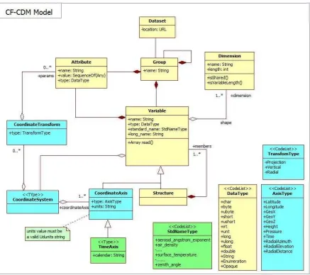
11.2.3 CF-netCDF grid data profile model
Copyright © 2009 Open Geospatial Consortium 27
Figure 4 - CF-netCDF profile model
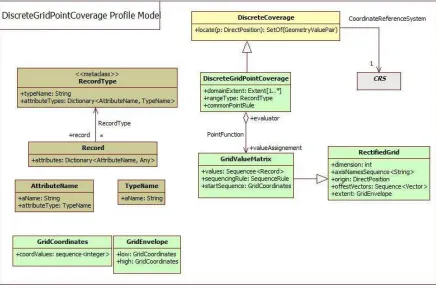
11.2.4 ISO DiscreteGridPointCoverage profile model
The present extension models only regularly spaced domains, adopting the following solution to describe and formalize the domain of discrete grid point coverages:
To implement a RectifiedGrid object (see Figure 5) and its valuation GridValueMatrix object: useful to model only regularly spaced domains
The specific DiscreteGridPointCoverage profile considered by this assumption is shown in Figure 5.
This profile can be used to model also ―engineering‖ grid data: datasets which are referred to a local defined coordinate system. In this case, the CRS is an application defined (i.e. engineering) CRS, characterized by an ―engineering‖ datum (see ISO 19111). The associated Coordinate System have the origin and offset attributes coincident with the data grid Cartesian system origin and axes versors.
Copyright © 2009 Open Geospatial Consortium 28
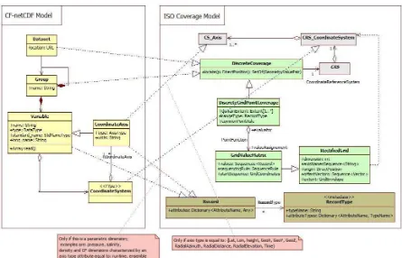
11.2.5 Mapping Rules (Normative)
The high level mapping schema is depicted in Figure 6. The schema shows the CF-netCDF elements to be used in order to generate the ISO 19123 elements which are implemented by the WCS specification.
The mapping rules are reported in the Table 1, Table 2 and Table 3; they are normative. Rules are expressed as relationships between model concepts and a set of constraints; we selected this approach to keep the mapping explanation as simple as possible.
Figure 6 - Mapping Schema
Copyright © 2009 Open Geospatial Consortium 29
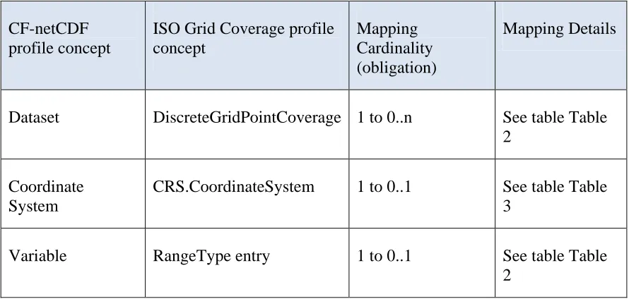
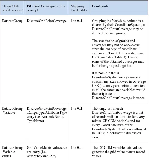
11.2.5.1 Dataset and Variables
Table 2. Summary of relationship between the CF-netCDF and the DiscreteGridPointCoverage profile models: Dataset package
CF-netCDF profile concept
ISO Grid Coverage profile concept
Mapping Cardinality (obligation)
Mapping Details
Dataset DiscreteGridPointCoverage 1 to 0..n See table Table 2
Coordinate System
CRS.CoordinateSystem 1 to 0..1 See table Table 3
Variable RangeType entry 1 to 0..1 See table Table
Copyright © 2009 Open Geospatial Consortium 30
CF-netCDF profile concept
ISO Grid Coverage profile concept
Mapping Cardinality
Constraints
Dataset.Group DiscreteGridPointCoverage 1 to 0..1 Grouping the Variables defined in a dataset by their CoordinateSystem, a DiscreteGridPointCoverage may be defined for each group.
The association of groups and coverages may not be one-to-one, since the concept of coordinate system in CF-netCDF is wider than CRS (see table Table 3). Hence, some of the obtained coverages may be further grouped together.
It is possible that a
CoordinateSystem entity does not contain any axes allowed in coverage CRS (i.e. only parametric dimension axes); the associated variables would then originate no
DiscreteGridPointCoverage instance.
Dataset.Group .Variable
DiscreteGridPointCoverage .RangeType.AttributesType entry (i.e. AttributeName, TypeName)
1 to 0..1 The range-set of each
DiscreteGridPointCoverage is a list of records with an attribute for every related CF-CDM variable and for every CoordinateAxis of the
CoordinateSystem that is not allowed in CRS (i.e. parametric dimension axes)
1 to 0..n The CF-CDM variable data values generate the grid value matrix record values.
11.2.5.2 Coordinate System and Grid Geometry
Copyright © 2009 Open Geospatial Consortium 31
CF-netCDF profile concept ISO Grid Coverage profile concept
Mapping Cardinality
Constraints
CoordinateSystem.CoordinateA xis (space dimension: axis type attribute equal to: Lat, Lon,
Height, GeoX, GeoY, GeoZ,
RadialAzimuth,
1 to 1 Parametric coordinate systems are allowed in CF-CDM but not in CRS2. A coordinate system is of type parametric if a physical or material property is used as a dimension [21]; valuable examples are pressure in
meteorology and density in in oceanography.
It is possible that a CoordinateSystem entity does not contain any axes allowed in coverage CRS (i.e. only
parametric dimension axes);
Only spatial and
temporal coordinates in a CF-CDM
CoordinateSystem become part of a
coverage CRS, whereas parametric dimension axes are mapped to compound range set components.
The domain of each coverage may be described by the extent of the related coordinate axis variables (if
Copyright © 2009 Open Geospatial Consortium 32
present).
The grid geometry of a DiscreteGridPointCovera ge may be slanted, with respect to the CRS axes, by specifying
appropriate offset vectors. However, the selected CF-netCDF profile permits
orthogonal grids only: grids which are aligned with the
CoordinateSystem axes.
CoordinateSystem.TimeAxis
(axis type attribute equal to: time) xis (parametric dimension; examples are: pressure, salinity, density and CF dimensions characterized by an axis type attribute equal to: runtime, ensemble).
DiscreteGridPointCov erage.RangeType.Rec ord.Attributes
1 to 0..1 See above
12 Limitations and future work
As noted in the GALEON IE, many of the difficulties in serving CF netCDF data via WCS 1.0 relate to the fact that, in effect, there are many coverages within one CF-compliant netCDF dataset. Some of these limitations remain in WCS 1.1. Since later versions of WCS are still under revision, the issues are listed here:
Copyright © 2009 Open Geospatial Consortium 33
currently possible as a file must always be accompanied with an XML manifest. At the time of writing change request has been submitted [OGC document 07-096] to request that this simple use case is still possible in subsequent versions of WCS.
NetCDF domain grids can be irregular; but WCS 1.1 provides only for regular and warped grids. Hence, for WCS 1.1, NetCDF grids are limited to those that a WCS 1.1 (actually a GML Coordinate Reference System Transformation) can describe.
CF-netCDF3 datasets often include data for multiple parameters (e.g. temperature, pressure, wind speed, etc.). Sometimes these different fields have different
domains which remains a problem in WCS 1.1
CF-netCDF3 datasets that contain the output of numerical forecast models in effect have multple time dimensions (the time the model was run and the set of forecast times.) Here again, mechanisms for dealing with this are still limited in WCS 1.1.
In general, many CF-netCDF3 datasets can be thought of as containing a set of coverages that correspond to multiple coverages (in the traditional sense of a 2D "layer"). For example a CF-netCDF3 dataset may contain multiple "parameters," multiple vertical layers and multiple times. Also, non-traditional (in GIS terms) views of the data may be required (e.g., Hovmoller diagrams where longitude is the x-axis and time is the y-axis)
In many netCDF datasets, the "height" dimension is represented by a non-spatial coordinate (e.g., pressure in the atmosphere or density in the oceans.) This is still not explicitly possible as a means for representing one of the domain dimensions in WCS 1.1. The main implication is that the bounding vertical limits in a
bounding box cannot be expressed in the native elevation dimension in such cases for the netCDF. But a co-domain axis can be defined using the non-spatial
dimension.
An issue that has arisen in GALEON is to include non-gridded coverages such as:
o collections of observational data taken at points (e.g., river gage or weather observation stations);
o trajectories such as vertical profiles in the atmosphere or ocean, and collections of such trajectories;
o time series of measurements at points or of "fields";
13 References
Proposed CF-netCDF WCS Encoding Profile
Copyright © 2009 Open Geospatial Consortium 34
List of URLs for netCDF and CF Conventions Documents
http://www.unidata.ucar.edu/projects/THREDDS/GALEON/netcdfAndCFwebpag es.html
Alternative forms for rendering netCDF metadata and data
http://www.unidata.ucar.edu/projects/THREDDS/GALEON/NetCDFandStandard s.htm
ISO/TC 211, ISO/PDTS 19103 Geographic information — Conceptual Schema Language, ISO/PDTS 19103:2003.
ISO/TC 211, ISO/FDIS 19123 Geographic information — Schema for coverage geometry and functions, ISO/FDIS 19123:2005(E).
UNIDATA, ―NetCDF‖, available at:
http://www.unidata.ucar.edu/software/netcdf/ BADC, ―CF Convention‖, available at:
Copyright © 2009 Open Geospatial Consortium 35
Annex A: Details of CF-netCDF describeCoverage response
(Normative)
Referring to the CF-netCDF – ISO 10123 model mapping rules, the following table maps the CF-netCDF elements into the corresponding WCS
Coverage description data structure
WCS describe Coverage element
CF-netCDF concept Mapping Cardinality
Constraints and conditions
Domain CoordinateSystema, b 1 to 1 For each coordinate system defined in a CF-netCDF dataset a WCS coverage is generateda, b
Range Dataset.Group.Variab
le
1 to N All the CF-netCDF group variables defined on a same coordinate systema, b generate a coverage range. A group may contains variables defined on different coordinate systemsa, b.
Range Dataset.Group 1 to 1 All the CF-netCDF group
variables must be defined on the same coordinate systema, b
SupportedCRS CoordinateSystemc, a 1 to 1
SupportedCRS CoordinateTransformc , a
1 to 1
SupportedFormatd ―CF-NetCDF‖ The coverage element value
shall be ―CF-NetCDF‖
a
For the mapping purpose, two CF-netCDF coordinate systems are considered different if they contain different spatial and temporal axes. They are not considered different if the only different axes are parametric ones (see the 11.2.5.2 paragraph).
b
Copyright © 2009 Open Geospatial Consortium 36
parametric axis value. That mainly depends on the parametric axis type and application.
c
The present extension considers CF-netCDF rectified grid object (see Figure 4) and its valuation GridValueMatrix object (see 11.2.4)
d
Naturally, it is possible to support other formats as well.
A.1 Domain of coverage data structure
WCS describe Coverage element
CF-netCDF concept Mapping Cardinality
Constraints and conditions
SpatialDomain CoordinateSystem.Co ordinateAxis
1 to Na The attribute
CoordinateAxis.type must be equal to: {Lat, Lon, Height,
GeoX, GeoY, GeoZ,
CoordinateAxis.type must be equal to: {time}
a
N = spatial axes number (i.e. 1, 2 or 3)
A.2 Range data structure
WCS describe Coverage element
CF-netCDF concept Mapping Cardinality
Constraints and conditions
Field Dataset.Group.Variab
le
1 to 1
A.3 Field data structure
Copyright © 2009 Open Geospatial Consortium 37
Coverage element Cardinality
Description Variable.name
Variable.standard_name
Variable.long_name
Variable.Attributea
Identifier Variable.name
or
Variable.standard_name
1 to 1
Definition Variable.units 1 to 1
NullValue Variable.FillValue 1 to 1
Axisb CoordinateSystem.Coor
dinateAxis
1 to 1 Parametric dimensions; examples are: pressure, salinity, density and CF dimensions characterized by an axis type attribute equal to:
runtime, ensemble)c
a
CF-netCDF Variable may be characterized by zero or more Attribute objects.
b
Zero or more parametric axes are allowed
c
Copyright © 2009 Open Geospatial Consortium 38
Annex B: Details of CF-netCDF getCoverage response (Normative)
The normal response to a valid GetCoverage operation request shall be a single coverage extracted from the coverage requested, with the specified spatial reference system, bounding box, size, format, and range subset.
The required output coverage metadata (see Table 5) or the equivalent information, shall be included with each WCS output coverage. Such equivalent metadata may be encoded within the netCDF file(s).
The GetCoverage operation response shall be XML encoded using the ―Coverages‖ data structure specified in Annex H.2 of the OGC document OGC 07-067r5 56. This
―Coverages‖ data structure allows the response to reference multiple files, and shall be output even when the GetCoverage operation response would otherwise contain only one file. The ―Coverages‖ data structure is based on the Manifest data structure specified in OWS Common 1.1 [OGC 06-121r3] (see Table 4).
The encoding of the GetCoverage response consists of a ―Coverages‖ XML document, packaged and bundled according to: the request encoding, and the value of the ―store‖ parameter.
According to the possible ―store‖ parameter values, two main cases are possible:
1) For ―store‖ equal to ‖true‖, a partial GetCoverage response is transferred to the client;
2) For ―store‖ equal to ―false‖, a complete GetCoverage response is transferred to the client.
For a complete GetCoverage response, the server shall transfer to the client both the ―Coverages‖ data structure and the Coverage values -e.g. through netCDF binary file(s).
For a partial GetCoverage coverage response, the server shall store the result file(s) at URL-addressable location(s) of its choosing, and return only the Coverages data structure with references to the other files.
B.1 General GetCoverage response for CF-netCDF data A general GetCoverage response considers three sections:
Copyright © 2009 Open Geospatial Consortium 39
iii)The Required Output Coverage Metadata -or equivalent information- (see Table 5). This is mandatory.
iv)Grid Coverage(s) Values. This is optional depending on the ―store‖ parameter value.
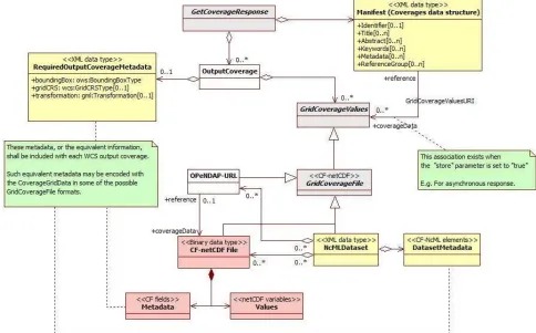
The abstract model of the general GetCoverage response with support for the CF-netCDF format is shown in
Copyright © 2009 Open Geospatial Consortium 40
Figure 7 - Abstract model of general WCS GetCoverage response for CF-netCDF data. Yellow objects are encoded as XML documents; red objects are encoded as binary files/sections;
gray objects are abstract.
Many of these classes are as per the WCS specification, but it is helpful to review them all here in the context of CF-netCDF delivery:
B.1.1 GetCoverageResponse
This is the response generated by a server to satisfy a generic getCoverage request for CF-netCDF data. The response consists of a set of OutputCoverages and a Manifest to describe the output coverages data structure.
B.1.2 OutputCoverage
This element is the coverage extracted from the coverage requested, with the specified spatial reference system, bounding box, size, format, and range subset.
Copyright © 2009 Open Geospatial Consortium 41
When an OutputCoverage object does not contain any GridCoverageValues, then, the Manifest object must be associated with at least one GridCoverageValues object through the GridCoverageValueURI association –i.e. the ―store‖ parameter of the GetCoverage request is set to ―true‖.
B.1.3 GridCoverageValues
This is an abstract element referring to the values of the output coverage extracted from the coverage requested. The output coverage values are structured as grid coverage data type. This element consists of one or more GridCoverageFile, being instantiated as either a CF-netCDF3File (binary data type) or a NcMLDataset document (XML data type).
This object is optionally associated to either a CoverageOutput instance or a Manifest instance, depending on the GetCoverage ―store‖ parameter value. In fact, the ―store‖ parameter specifies whether response coverage should be stored, remotely from client at network URL; in that case the OutputCoverage does not include a GridCoverageValues object; while, the Manifest provides a reference to it –see the GridCoverageValuesURI association.
B.1.4 Manifest (Coverages data structure)
The manifest object is an XML document describing the content of the package
containing the OutputCoverage values, returned by a GetCoverageResponse. A manifest can be used to quickly determine the content of the package without having to scan the package content (i.e. the GridCoverageValues objects content). The specified Manifest lists and describes the GridCoverageValues data structure: each resource bundled in the returned package. When the ―store‖ parameter of the GetCoverage request is set to ―true‖, the Manifest provides the necessary reference to the stored GridCoverageValues resources (see the GridCoverageValuesURI association). How the resources are packaged is irrelevant; for example, a package may be a zip file or a multi-part mime message [OGC 06-121r3].
According to the OGC Web Services Common Specification [OGC 06-121r3], the Manifest data structure is described in Table 4.
Table 4. Manifest data structure [OGC 06-121r3: Table 45]
Names Definition Data type Multiplicity and use
identifier
Identifier
An unambiguous identifier of this Manifest document, normally used by software
Copyright © 2009 Open Geospatial Consortium 42
title e
Title
Title of this Manifest document, normally used for display to a human
LanguageString data structure, see Figure 15
Zero or more (optional)Include when available and useful b
Include one for each language represented
abstract e
Abstract
Brief narrative description of this Manifest document, normally available for display to a human
LanguageString data structure, see Figure 15
Zero or more (optional)Include when available and useful
Include one for each language represented
keywords e
Keywords
Unordered list of one or more commonly used or formalised word(s) or phrase(s) used to describe this Manifest document
MD_Keywords class about this Manifest document c
reference to metadata or metadata contents, see
gml:metaDataPropert y d
Zero or more (optional)
One for each useful metadata object
reference Group
Reference Group
References to a logical group of documents or
resources within this manifest document
ows:ReferenceGroup Type, see Table 46
Zero or more (optional)
One for each group included
B.1.5 RequiredOutputCoverageMetadata
This object introduces the required metadata to describe each output coverage. This XML data type element is optional because the equivalent information (i.e the required output metadata) can be encoded with the coverage in the CF-netCDF file encoding. Two file encodings are allowed: netCDF binary file and, ncML document file. The metadata data structure is specified in Table 5 [OGC 07-067r5].
Copyright © 2009 Open Geospatial Consortium 43
Names a Definition Data type Multiplicity and use
boundingBox BoundingBox
Bounding box that specifies extent of output coverage
ows:BoundingBoxType in
CRS of output coverage b
One (mandatory)
gridCRS
GridCRS
Definition of GridCRS used by output coverage
wcs:GridCRSType Zero or one
(conditional)
Include when GridCRS used by BoundingBox
Transformation
Include when output coverage is not georectified but is georeferenced
a See Table 1 of [OGC 06-121r3] for UML and XML naming conventions.
b The Coordinate Reference System (CRS) of an output coverage may be either a GridCRS
or an ImageCRS.
B.1.6 GridCoverageFile
This abstract element specializes a GridCoverageValue being instantiated as a netCDF coverage dataset; the following encoding possibilities are foreseen: a) a CF-netCDF3File (binary data type); b) a NcMLDataset document (XML data type); c) an OPeNDAP reference. It contains the values, and optionally the required metadata, of an Output Coverage.
This element may be either bundled in the package containing the OutputCoverage values (i.e. ―store‖ parameter = ―false‖), or stored at an URI-addressable location (i.e. ―store‖ parameter = ―true‖).
B.1.7 GridCoverageValuesURI association
Copyright © 2009 Open Geospatial Consortium 44
B.1.8 CF-netCDF file
This element realizes a GridCoverageFile. It represents a netCDF ver. 3.0 binary file, complying with the CF ver. 1.1 conventions. The element contains data Values, encoded as netCDF variables, and Metadata encoded as CF fields. These metadata can contain the required information for each output coverage, avoiding to include the
RequiredOutputCoverageMetadata element.
A CF-netCDF file may be accessed directly or can be referenced by: a) a ncML dataset; b) an OPeNDAP URL.
B.1.9 NcMLDataset
This element realizes a GridCoverageFile. It represents a ncML ver. 1.0 document. A ncML document provides the XML encoding of one or more CF-netCDF file. For performances sake, a ncML document generally encodes only the CF-netCDF metadata leaving the data values in the binary format and providing pointers (i.e. references) to those. Thus, the element contains a mandatory MetadataDataset object (i.e. the encoded file metadata), and optionally points to the binary file(s) for values. The MetadataDataset can contain the required information for each output coverage, avoiding to include the RequiredOutputCoverageMetadata element.
A ncML document may point to the data values: a) directly –i.e. referencing a
CF-netCDF file; b) including an OPeNDAP URL –which in turn reference a CF-netCDF file.
B.1.10 OPeNDAP-URL
This element realizes a GridCoverageFile. Actually, this is a reference to a CF-netCDF file. In fact, OPeNDAP is a relatively simple approach (Web protocol) that allows applications to access remote, time-aggregated collections of netCDF-CF files (virtual datasets –often terabyte sized) through the unaltered netCDF API –as if they were local netCDF files.
An OPeNDAP-URL instance may also be contained by a NcMLDataset object to reference a CF-netCDF file –the actual binary data.
B.2 Content model of the WCS complete GetCoverage response for CF-netCDF3 binary file
This section describes the package returned by a complete GetCoverage response packaging CF-netCDF3 binary file(s).
Copyright © 2009 Open Geospatial Consortium 45
Figure 8 - Data bundle structure transferred by a general WCS complete GetCoverage response returning a CF-netCDF3 binary file
The Required Output Coverage Metadata XML section is optional. In fact, the required metadata can be encoded in the CF-netCDF data file.
If present, the Required Output Coverage Metadata XML section should use the XML encoding referenced in Sub-clause 10.3.9 of the OGC 07-067r5 document.
If the Required Output Coverage Metadata XML section is not present, then the CF-netCDF grid coverage file(s) must contain the equivalent information. The structure of these metadata elements is described in the A.1.1 (Implementing the required output coverage metadata as CF fields) paragraph.
Copyright © 2009 Open Geospatial Consortium 46
The GridCoverageValue section of the response may contain: a) CF-netCDF3 binary file(s); b) OPeNDAP URL(s) which point(s) to CF-netCDF3 binary file(s).
OPenDAP URL may be encoded using one of the following options: i) a specific MIME type for an OPeNDAP endpoint –analogous to application/x-jpip-xml; ii) an HTML document containing the OPeNDAP URL; iii) a simple text –semantically, this is the worst solution.
Since both XML Manifest and Grid Coverage Values (i.e. netCDF3 binary file(s) and/or OPeNDAP URLs) are mandatory, then a WCS Complete GetCoverage response must be a multipart message.
B.3 Complete GetCoverage response for ncML document
The netCDF community makes use of ncML to encode complex netCDF data structures. In fact it is possible to use ncML elements to define a virtual netCDF dataset which consists of one or more netCDF data files.
In a complete GetCoverage response returning a ncML/CF-netCDF document, the Grid CoverageValues are encoded and returned according to one or more of the following options:
1. XML encoded values conforming to the ncML schema: this ncML section encodes the content of a CF-netCDF binary file.
2. NetCDF3 binary files (i.e. GridCoverageFile instances) attached to an ncML document.
3. OPenDAP URL encoded in the ncML schema: actually, this ncML section references the content of a CF-netCDF3 binary file.
In any case, the coverage metadata section is encoded in the ncML document as elements conforming to the ncML schema.
Therefore, it is possible to find the same metadata content both in the Coverage metadata section and in the attached netCDF3 binary file(s), expressed as CF fields. In that case, to avoid an inconsistency situation, the ncML document elements must be considered as the reference metadata values.
This type on encoding allows to return very complex packages; for example, more than one output coverage (i.e. dataset) each of them containing/referring-to more than one CF-netCDF file.
Copyright © 2009 Open Geospatial Consortium 47
Figure 9 - Data bundle structure transferred by a general WCS complete GetCoverage response returning a ncML/CF-netCDF document
Copyright © 2009 Open Geospatial Consortium 48
enclosed as attachments to the ncML document. Others may be directly encoded in the ncML dataset document. Eventually, others may be referred through OPenDAP URLs.
B.5 Partial GetCoverage response
A partial coverage response refers to a coverage request characterized by the "store" output attribute set to "true".
If the ―store‖ parameter has the value ―true‖, the server shall store the result file(s) at URL-addressable location(s) of its choosing, and return only the Coverages data structure with references to the other files.
This output structure element specifies whether response coverage should be stored remotely from client at a network URL (more generally a URI), instead of being returned within the operation response. The remote URI is contained in the getCoverage response.
The default value is "false". A partial response is useful to enable asynchronous requests to a WCS server which is able to support this type of functionality.
The partial getCoverage response may consist of the ―Coverages‖ data structure (the ows:coverage element) containing the required output metadata (i.e. the
ows:CoverageMetadata); the remote URI is encoded in this section.
Another option consists of returning a ncML based response. This XML document contains the required coverage output metadata and the the remote URI, where to retrieve the netCDF file(s).
B.6 WCS GetCoverage response: Multipart data encoding
Multipart data encoding is a technique for transferring multiple contents inside a single HTTP Response. In the context of WCS GetCoverage responses it can be adopted whenever a binary content must be transferred.
Different strategies should be adopted for the different possible cases. Table 6 shows the four possibilities:
Table 6. Multipart possible strategies
Case Request Target Possible Responses
Specification
#1 SOAP binary data SOAP with
binary
Copyright © 2009 Open Geospatial Consortium
binary data MIME Multipart with binary parts
MIME
ncML data MIME Multipart with ncML parts
MIME
multipart/related
The WCS GetCoverage response can be encoded in a Multipart message. The encoding strategy is different depending on the use of SOAP or HTTP binding.
B.6.1 Case #1 SOAP with binary data
In case of SOAP with binary data, the response can refer to local or remote resources using the Manifest. Local resources are always attached to the message, while remote resources can be attached as a copy to avoid multiple access. The SOAP response must be encoded along with its attachments in a MIME multipart/related message using the following rules:
1) A world-unique content MUST be assigned to each attached binary content.
2) In the Manifest, every reference to the local binary contents MUST be
transformed in a related-part reference according to the ―cid‖ schema [RFC 2387] using the proper Content-ID. References to the attached remote binary contents MAY be transformed in a related-part reference according to the ―cid‖ schema [RFC 2387] using the proper Content-ID;
3) The first part of the Multipart message (root) MUST contain the SOAP Envelope including the Manifest.
4) Each one of the following parts MUST include one binary content. The Content-ID header refers to the corresponding content identifier. For remote resources, the Content-Location header refers to the real location of the binary content.
Example (SOAP Request of two netCDF data items and metadata)
Copyright © 2009 Open Geospatial Consortium 50
Content-Type: multipart/related; boundary="----=_NextPart_000_0000_93251752.3C5526C0"
---=_NextPart_000_0000_93251752.3C5526C0 Content-Type: application/xml; charset="UTF-8"
<?xml version="1.0" encoding="UTF-8"?>
<soap:Envelope xmlns:soap="http://www.w3.org/2001/12/soap-envelope"> <soap:Header/>
<soap:Body>
<Coverages xmlns="http://www.opengis.net/wcs/1.1/ows" xmlns:ows="http://www.opengis.net/ows" xmlns:xlink="http://www.w3.org/1999/xlink" xmlns:xsi="http://www.w3.org/2001/XMLSchema-instance" xmlns:schemaLocation="http://www.opengis.net/wcs/1.1/ows ../owsCoverages.xsd http://www.opengis.net/ows ../../../ows/1.0.0/ows19115subset.xsd">
<Coverage>
<ows:Title>Example</ows:Title>
<ows:Abstract>Example of coverage</ows:Abstract> <Identifier>Example</Identifier>
<Reference href="cid:[email protected]" /> <Reference href="cid:[email protected]" /> <Reference href="http://example.net/data/data2.nc" /> </Coverage>
</Coverages> </soap:Body> </soap:Envelope>
---=_NextPart_000_0000_93251752.3C5526C0 Content-Type: application/xml
Content-ID: <[email protected]>
...(metadata content)...
Copyright © 2009 Open Geospatial Consortium 51
Content-Transfer-Encoding: base64 Content-ID: <[email protected]>
...(1st data content in netCDF)...
---=_NextPart_000_0000_93251752.3C5526C0 Content-Type: application/CF-netCDF3
Content-Transfer-Encoding: base64 Content-ID: <[email protected]>
Content-Location: http://example.net/data/data2.nc
...(2nd data content in netCDF)...
---=_NextPart_000_0000_93251752.3C5526C0--B.6.2 Case #2 HTTP Response with binary data
In case of a HTTP Response with binary data, the response can refer to local or remote resources using the Manifest. Local resources are always attached to the message, while remote resources can be attached as a copy to avoid multiple access. The HTTP response must be encoded along with its attachments in a MIME multipart/related message using the following rules:
1) A world-unique content MUST be assigned to each attached binary content.
2) In the Manifest, every reference to the local binary contents MUST be
transformed in a related-part reference according to the ―cid‖ schema [RFC 2387] using the proper Content-ID. References to the attached remote binary contents MAY be transformed in a related-part reference according to the ―cid‖ schema [RFC 2387] using the proper Content-ID;
3) The first part of the Multipart message (root) MUST contain the SOAP Envelope including the Manifest..
4) Each one of the following parts MUST include one binary content. The Content-ID header refers to the corresponding content identifier. For remote resources, the Content-Location header refers to the real location of the binary content.
Example (HTTP Request of two netCDF data items and metadata)