Geological Identification of...(Pandita )
Available online at http://Journals.ums.ac.id/index.php/fg/article/view/1508
Geological Identification of Seismic Source at Opak Fault Based on
Stratigraphic Sections of the Southern Mountains
Hita Pandita1, Sukartono, Agustinus Isjudarto
Sekolah Tinggi Teknologi Nasional Yogyakarta 1Corresponding author (email: [email protected]) Abstract
Earthquake is one of the unpredicted natural disasters on our earth. Despite of the absence of
high-accuracy method to precisely predict the occurrence of earthquake, numerous studies have been carried out by seismologists to find it. One of the efforts to address the vulnerability of a region to earthquakes is by recognizing the type of rock as the source of the earthquake. Opak Fault is an active fault which was thought to be the source of earthquakes in Yogyakarta and adjacent areas. This study aimed to determine the seismic source types of rocks in Yogyakarta and adjacent areas. The methods were by measuring
stratigraphic sections and the layer thickness in the western part of Southern Mountains. Field study was
done in 6 (six) research sites. Results of stratigraphic measurement indicated the sedimentary rocks in the
Southern Mountains was 3.823 km in thick, while the bedrock was more than 1.042 km in thick. Based on the result, the rock types as the seismic source were thought to originate from the continental crust rocks formed of granite and metamorphic complex.
Keywords: Earthquake, Prediction, Southern Mountains, Yogyakarta, Stratigraphic.
Abstrak
Gempa bumi merupakan salah satu bencana alam yang belum bisa diprediksi waktu kejadiannya sampai saat ini. Sejumlah penelitian telah dilakukan oleh banyak ahli kegempaan untuk bisa menemukan metode prediksi gempa yang akurat. Namun sampai saat ini belum ada yang berhasil. Salah satu hal yang perlu diketahui dalam upaya memprediksi gempa adalah mengetahui jenis batuan yang menjadi sumber gempa. Sesar Opak merupakan sesar aktif yang mengakibatkan sejumlah gempa kuat di wilayah Yogyakarta dan sekitarnya. Penelitian ini ditujukan untuk mengetahui jenis batuan sumber gempa di wilayah Yogyakarta. Metode yang digunakan berupa pengukuran stratigrafi dan tebal batuan di Pegunungan Selatan bagian barat. Penyelidikan lapangan dilakukan di enam lokasi. Hasil pengukuran stratigrafi menunjukkan total ketebalan batuan sedimen pada Pegunungan Selatan adalah 3,823 km, sedangkan tebal batuan dasar diperkirakan lebih dari 1,042 km. Berdasarkan hal tersebut batuan sumber gempa diperkirakan berasal dari batuan kerak kontinen yaitu granit, serta kompleks batuan metamorf.
Kata kunci: Gempa, Prediksi, Pegunungan selatan, Yogyakarta, Stratigrafi.
Introduction
The occurrence of an earthquake as one of natural disasters is hardly predicted, despite the efforts of a number of plate tectonic expert
and seismologists in carrying out studies to find out how to estimate earthquake precisely. Those studies, in fact, have not yielded any satisfying results. Matsushima (1961) found that there is the relationship between distribution of great earthquakes with strength of the crust and upper mantle.
Yogyakarta is an earthquakes prone area where several powerful earthquake measuring 6 in
magnitude occurred several times. Newcomb
and McCann (1987), Utsu (2002), Elnashai et al. (2006), and USGS (2007), record a number
of earthquakes have struck off the region of Yogyakarta and adjacent areas during the period of 1840 to 2006. Several powerful earthquakes took place in adjacent to Opak Fault (Sesar Opak) (Thant, et al., 2008) which were considered as shallow focus earthquakes with epicenter depth of 10 km.
microzonation in Yogyakarta and generated a microzonation map. Meanwhile, Thant et al. (2008) carried out a study to estimate the
focal depth of the earthquake potentials in Yogyakarta.
As a matter of fact, previous studies have not elaborated the types of rocks as the source of the earthquake. Adequate knowledge on seismic types of rock is required as an initiation to estimate the potential location of the earthquakes in the future. This study aimed to measure the stratigraphic section
of the western part of Southern Mountains. In addition, the final goal of this study was to provide an initial interpretation of the seismic source types of rock in the area adjacent to Opak fault. This study was a part of research on earthquake prediction in Yogyakarta and adjacent areas.
Research Methods
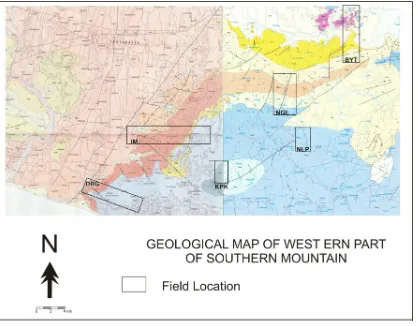
The method applied in this study consisted of stratigraphic measurements and geological surface mapping of the site. The mapping covered Yogyakarta region and Klaten regency (Figure 1). Those sites were expected to provide ample data with regard to the types of rock as the source of the earthquake. Additionally, four observation sites were determined.
The results of the ground study were subsequently analyzed from stratigraphic perspective as well as calculated to obtain the stratigraphic thickness at the western part of Southern Mountains. The measurement was also performed on the younger rock layer to gain an understanding of the past earthquakes. The rocks samples from the sites are collected and analyzed in the laboratory. The laboratory analysis is petrology description.
Source: Geological Maps (Rahardjo, etal., 1995; Surono, etal., 1992)
Data and Analysis
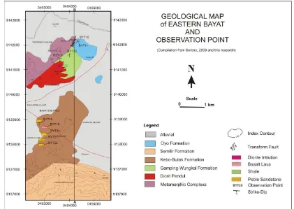
As many as 6 (six) stratigraphic or geologic sections of the 6 (six) sites had been examined in this study. The results and analysis can be explained as follows. Field study in Bayat was done from the north to the south of the northern part of Joko Tuo the southern part of Trembono, which consisted of 9 (nine) sites along the route. Based on the field data compiled with the regional geological map, a geological map and its section was constructed (Figure 3).
Stratigraphic sequence of the site is constituted from the metamorphic complex rocks allegedly formed in the Pre-Tertiary period. Erratically, the top of the metamorphic complex is overlain by Oligocene to early Miocene limestone of
the Gunung Wungkal Formation (Surono, et
al., 1992). Limestone-Wungkal Formation is unconformably overlain by Kebo-Butak Formation of basaltic sills at the bottom allegedly formed in the Oligocene to early Miocene (Atmaja, et al., 1995 and Surono, 2008). Subsequently, Kebo-Butak Formation
are overlain by the early Miocene Semilir Formation. The total layer thickness of Bayat
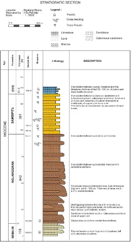
site in accordance with the measurement of the cross-section indicated the thickness (t)
measured perpendicularly to bedding plane
(Figure 3). The results showed the thickness of sedimentary rocks (t1) of 2.37 km, whereas the metamorphic complex (t2) was 1.04 km.
Field study in Ngalang River (Kali Ngalang) site was carried out by measuring north-south stratigraphic section across Ngalang River to Oyo River. Samplings were conducted at 11 observation points. A measured stratigraphic section was attained from the field investigation that contained 4 (four) formations at Ngalang River (Figure 4). The bottom is the early Middle Miocene that is unconformably overlain by the Middle Miocene Nglanggran Formation. The late Middle Miocene Sambipitu Formation is conformably overlain by the youngest formation in Ngalang River, which is Oyo Formation (Pandita and Sukartono, 2014). The total layer thickness of Ngalang River measured section is approximately 1405.3 m.
Figure 3. Stratigraphic section of Bayat and adjacent areas, t
1: sedimentary rocks thickness, t2:
metamorphic rocks thickness.
Figure 5. Measured Stratigraphic section of Nglipar.
The research site was in Oyo River precisely in Nglipar started from the bridge in Nglipar-Wonosari road to the upstream of Oyo River. Based on the geographical position, it lies at 9125466 S and 49 M 0456939 E. In general, Wonosari Formation in Karangmojo and adjacent areas primarily consists of limestone. However, limestone comprises a fine fraction
of limestone particles and a coarser fraction of limestone (Figure 5). Overally, limestones in
this area have endured karstification process identified from the layered rocks. It reaches
25.7 m in thick. The research site was in Kepek Sub-village in the southwest Wonosari. A trajectory was established in one of the hills. Its geographical position is at 9119262 S and 49 M 0444248 E. It is a thick tuffaceous marls with limestone on top of them. These rock units are part of Kepek Formation. At the bottom of the formation is tuffaceous marls with abundant planktonic foraminifera (Figure
6). It is overlain by coarse limestone with high
foraminifera content. Total thickness of Kepek
Figure 6. Stratigraphic section of Kepek Formation as measured in Kepek Sub-village.
Total Layer Thickness of Southern Mountains
Measurement of the layer thickness was carried out by two methods, namely the stratigraphic measurements in the sites and the reconstruction of the geological section.
The results of the geological section of Bayat indicated the stratigraphic sequence from the oldest to the youngest, respectively is as follows: Metamorphic Complex, Limestone-Wungkal Formation, Kebo-Butak Formation, and Semilir Formation (Figure 3). Based on the analysis on the section, the layer thickness (t) measured perpendicularly to bedding plane (Figure 3) was determined. The sedimentary rocks (t1) was 2.37 km in thick while metamorphic complex (t2) was approximately 1.04 km in thick.
Direct measurement methods in the field were done in three sites, namely, Nglipar (NLP), Kepek (KPK) and Ngalang River (NGL). The Formasi Oyo-Wonosari Formation in Nglipar (NLP) was measured and the result was 25.7
m in thick. In the area Kepek (KPK), Kepek Formation was calculated with the result of 24 m in thick. In Ngalang River (NGL), there are four formations, namely Semilir Formation, Nglanggran Formation, Sambipitu Formation and Oyo Formation, with a thickness of 1405.3 m. Thus the total layer thickness of threes sites was 1.455 km.
Based on these two methods, the total thickness of sedimentary rocks in the Southern Mountains was obtained of 3.823 km. Furthermore, the bedrock thickness of Southern Mountains in the form of metamorphic rocks was estimated approximately 1.042 km. Compilation of regional data indicated the possibility of higher thickness of the bedrock as identified by the seismic data (Figure 7) (Prasetyadi, 2007).
Figure 7. Seismic-based Interpretation of East Java Subsurface from Rembang Zone to Southern Mountains demonstrates the bedrock thickness (Prasetyadi, 2007).
The result of field study supported by several literatures (Prasetyadi, 2007; Surono, et al.,
1992; and Rahardjo, et al., 1995) indicated
the bedrock of Southern Mountains basin is formed by metamorphic complex. To determine whether the bedrock was the seismic source, several approaches were carried out as follows.
In accordance with the several literature studies, the earthquake occurred in adjacent to Opak Fault was at a depth of +10 km (Pandita,
etal., 2013, and Thant, etal., 2008). The total
are two possible types of rock as the seismic source in the adjacent areas of Opak Fault, namely, the metamorphic complex and older rocks of the metamorphic complex. In fact, thickness of sedimentary rocks that reach 3.823 km in thick. Nevertheless, the thickness of bedrock of Southern Mountains in the form of metamorphic rocks was estimated reaching approximately 1.042 km. In accordance with the compilation of seismic data, the thickness of sedimentary rocks and bedrock was more than 5 km.
Based on epicenter data, the earthquake occurred in adjacent to Opak River was at 10 km in depth. Subsequently, the data was compiled with the total layer thickness of Southern Mountains. The seismic source type of rock was allegedly came from the bedrock of Southern Mountains basin. The bedrock is formed by metamorphic complex.
Acknowledgement
This research was a part of the Competitive Grant (Hibah Bersaing) funded by the
Directorate of Higher Education (DIKTI) for
the fiscal year 2014-2015. The researchers would like to express gratitude for the student assistants who support the process of data collection, both in the field and the laboratory.
Reference
Atmadja, R. S., Maury, R.C., Bellon, H., Pringgopawiro, H., Polve, M., and Priadi, B., 1994.
Tertiary magmatic belts in Java. Journal of SE Asian Earth Sciences, 9, h.13-27.
Matsushima, S, 1961, On The Strength Distribution of The Earth’s Crust and The Upper Mantle, and The Distribution of The Great Earthquakes With Depth, Disaster Prevention research Institute Bulletin, No. 43, Kyoto University, Japan.
Newcomb K. R. and McCann, W. R., 1987: “Seismic History and Seismotectonics of the Sunda Arc”, Journal of Geophysical Research, Vol. 92, No. B1, pp 421-439. American Geophysical Union.
Pandita, H. dan Sukartono, 2014, Kali Ngalang Exposed Geohistory of Southern Mountain, Proc. International Symposium of Geoheritage, UPN Yogyakarta.
Pandita, H., Isnawan, D., dan Winarti, 2012, Mikrozonasi Tingkat Resiko Bancana di Wilayah Yogyakarta Berdasarkan Kajian Proses Geologi Masa Lampau Dan Sekarang, Laporan
Penelitian Hibah Bersaing Tahun I, Sekolah Tinggi Teknologi Nasional, Yogyakarta Pandita, H., Isnawan, D., dan Winarti, 2013, Mikrozonasi Tingkat Resiko Bancana di Wilayah
Yogyakarta Berdasarkan Kajian Proses Geologi Masa Lampau Dan Sekarang, Laporan
Penelitian Hibah Bersaing Tahun II, Sekolah Tinggi Teknologi Nasional, Yogyakarta Prasetyadi, C., 2007, Evolusi Tektonik Paleogen Jawa Bagian Timur, Doctoral Thesis,
Unpublished, ITB
Surono, 2008, Litostratigrafi dan Sedimentasi Formasi Kebo dan Formasi Butak di Pegunungan
Baturagung, Jawa Tengah Bagian Selatan, Jurnal Geologi Indonesia, Vol. 3 No. 4
Desember 2008: 183-193, Puslitbang Geologi
Surono, Toha, B., dan Sudarno, I., 1992, Peta Geologi Lembar Surakarta Giritontro, Jawa,
Pusat Penelitian dan Pengembangan Geologi, Bandung.
Thant, M., Kawase, H., Pramumijoyo, S., Hendrayana, H., and Adi, A. D., 2008, Focal Mechanisms of Subduction Zone Earthquakes Along The Java Trench: Preliminary Study For The PSHA For Yogyakarta Region, Indonesia, The 14th World Conference on Earthquake Engineering October 12-17, 2008, Beijing, China.
Utsu, T. 2002, A List of Deadly Earthquakes in the World 1500-2000, International Handbook of Earthquake & Engineering Seismology, Part A, Academic Press, An Imprint of Elsevier