Open Geospatial Consortium
Approval Date:2012-01-16 Publication Date: 2012 –02-07 External identifier of this OGC® document: http://www.opengis.net/spec/GML/3.3
Reference number of this OGC® document:OGC 10-129r1 Version: 3.3.0
Category
: OpenGIS
® Implementation Standard Editor:
Clemens PorteleOGC® Geography Markup Language (GML) — Extended
schemas and encoding rules
Copyright © 2012 Open Geospatial ConsortiumCopyright © 2012 Open Geospatial Consortium To obtain additional rights of use, visit http://www.opengeospatial.org/legal/.
This document is an OGC Member approved international standard. This document is available on a royalty free, non-discriminatory basis. Recipients of this document are invited to submit, with their comments, notification of any relevant patent rights of which they are aware and to provide supporting documentation.
Document type: OpenGIS® Implementation Standard Document subtype: Encoding
License Agreement
Permission is hereby granted by the Open Geospatial Consortium, ("Licensor"), free of charge and subject to the terms set forth below, to any person obtaining a copy of this Intellectual Property and any associated documentation, to deal in the Intellectual Property without restriction (except as set forth below), including without limitation the rights to implement, use, copy, modify, merge, publish, distribute, and/or sublicense copies of the Intellectual Property, and to permit persons to whom the Intellectual Property is furnished to do so, provided that all copyright notices on the intellectual property are retained intact and that each person to whom the Intellectual Property is furnished agrees to the terms of this Agreement.
If you modify the Intellectual Property, all copies of the modified Intellectual Property must include, in addition to the above copyright notice, a notice that the Intellectual Property includes modifications that have not been approved or adopted by LICENSOR.
THIS LICENSE IS A COPYRIGHT LICENSE ONLY, AND DOES NOT CONVEY ANY RIGHTS UNDER ANY PATENTS THAT MAY BE IN FORCE ANYWHERE IN THE WORLD.
THE INTELLECTUAL PROPERTY IS PROVIDED "AS IS", WITHOUT WARRANTY OF ANY KIND, EXPRESS OR IMPLIED, INCLUDING BUT NOT LIMITED TO THE WARRANTIES OF MERCHANTABILITY, FITNESS FOR A PARTICULAR PURPOSE, AND NONINFRINGEMENT OF THIRD PARTY RIGHTS. THE COPYRIGHT HOLDER OR HOLDERS INCLUDED IN THIS NOTICE DO NOT WARRANT THAT THE FUNCTIONS CONTAINED IN THE INTELLECTUAL PROPERTY WILL MEET YOUR REQUIREMENTS OR THAT THE OPERATION OF THE INTELLECTUAL PROPERTY WILL BE UNINTERRUPTED OR ERROR FREE. ANY USE OF THE INTELLECTUAL PROPERTY SHALL BE MADE ENTIRELY AT THE USER’S OWN RISK. IN NO EVENT SHALL THE COPYRIGHT HOLDER OR ANY CONTRIBUTOR OF INTELLECTUAL PROPERTY RIGHTS TO THE INTELLECTUAL PROPERTY BE LIABLE FOR ANY CLAIM, OR ANY DIRECT, SPECIAL, INDIRECT OR CONSEQUENTIAL DAMAGES, OR ANY DAMAGES WHATSOEVER RESULTING FROM ANY ALLEGED INFRINGEMENT OR ANY LOSS OF USE, DATA OR PROFITS, WHETHER IN AN ACTION OF CONTRACT, NEGLIGENCE OR UNDER ANY OTHER LEGAL THEORY, ARISING OUT OF OR IN CONNECTION WITH THE IMPLEMENTATION, USE, COMMERCIALIZATION OR PERFORMANCE OF THIS INTELLECTUAL PROPERTY.
This license is effective until terminated. You may terminate it at any time by destroying the Intellectual Property together with all copies in any form. The license will also terminate if you fail to comply with any term or condition of this Agreement. Except as provided in the following sentence, no such termination of this license shall require the termination of any third party end-user sublicense to the Intellectual Property which is in force as of the date of notice of such termination. In addition, should the Intellectual Property, or the operation of the Intellectual Property, infringe, or in LICENSOR’s sole opinion be likely to infringe, any patent, copyright, trademark or other right of a third party, you agree that LICENSOR, in its sole discretion, may terminate this license without any compensation or liability to you, your licensees or any other party. You agree upon termination of any kind to destroy or cause to be destroyed the Intellectual Property together with all copies in any form, whether held by you or by any third party.
Except as contained in this notice, the name of LICENSOR or of any other holder of a copyright in all or part of the Intellectual Property shall not be used in advertising or otherwise to promote the sale, use or other dealings in this Intellectual Property without prior written authorization of LICENSOR or such copyright holder. LICENSOR is and shall at all times be the sole entity that may authorize you or any third party to use certification marks, trademarks or other special designations to indicate compliance with any LICENSOR standards or specifications.
This Agreement is governed by the laws of the Commonwealth of Massachusetts. The application to this Agreement of the United Nations Convention on Contracts for the International Sale of Goods is hereby expressly excluded. In the event any provision of this Agreement shall be deemed unenforceable, void or invalid, such provision shall be modified so as to make it valid and enforceable, and as so modified the entire Agreement shall remain in full force and effect. No decision, action or inaction by LICENSOR shall be construed to be a waiver of any rights or remedies available to it.
III
Warning
4 Copyright © 2012 Open Geospatial Consortium
Contents
PageForeword ... 5
Introduction ... 6
1
Scope ... 8
2
Conformance ... 8
3
Normative references ... 9
4
Terms and symbols ... 9
5
Conventions ... 10
6
Additional basic types ... 12
7
Compact Encodings of Commonly Used GML Geometries ... 15
8
Triangulated Irregular Networks ... 23
9
Linear Referencing ... 29
10
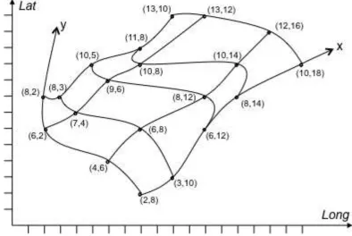
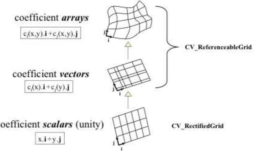
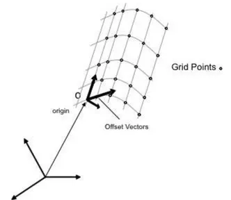
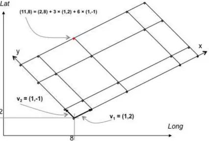
ReferencableGrid ... 59
11
Code lists, dictionaries and definitions ... 72
12
Encoding rule ... 75
Annex A Linear referencing method examples (informative) ... 86
Foreword
Attention is drawn to the possibility that some of the elements of this document may be the subject of patent rights. The OGC shall not be held responsible for identifying any or all such patent rights.
Recipients of this document are requested to submit, with their comments, notification of any relevant patent claims or other intellectual property rights of which they may be aware that might be infringed by any implementation of the standard set forth in this document, and to provide supporting documentation.
The Geography Markup Language (GML) was originally developed within the Open Geospatial Consortium, (OGC). ISO 19136:2007 was prepared by ISO/TC 211 jointly with OGC.
6 Copyright © 2012 Open Geospatial Consortium
Introduction
Geography Markup Language is an XML grammar written in XML Schema for the description of application schemas as well as the transport and storage of geographic information.
The key concepts used by Geography Markup Language (GML) to model the world are drawn from the ISO 19100 series of International Standards and the OpenGIS Abstract Specification.
A feature is an "abstraction of real world phenomena" (ISO 19101); it is a geographic feature if it is associated with a location relative to the Earth. So a digital representation of the real world may be thought of as a set of features. The state of a feature is defined by a set of properties, where each property may be thought of as a {name, type, value} triple.
The number of properties a feature may have, together with their names and types, is determined by its type definition. Geographic features with geometry are those with properties that may be geometry-valued. A feature collection is a collection of features that may itself be regarded as a feature; as a consequence a feature collection has a feature type and thus may have distinct properties of its own, in addition to the features it contains.
Following ISO 19109, the feature types of an application or application domain is usually captured in an application schema. A GML application schema is specified in XML Schema and can be constructed in two different and alternative ways:
by adhering to the rules specified in ISO 19109 for application schemas in UML, and conforming to both the constraints on such schemas and the rules for mapping them to GML application schemas specified in this International Standard;
by adhering to the rules for GML application schemas specified in this International Standard for creating a GML application schema directly in XML Schema.
Both ways are supported by this International Standard. To ensure proper use of the conceptual modelling framework of the ISO 19100 series of International Standards, all application schemas are expected to be modelled in accordance with the General Feature Model as specified in ISO 19109. Within the ISO 19100 series, UML is the preferred language by which to model conceptual schemas.
GML specifies XML encodings, conformant with ISO 19118, of several of the conceptual classes defined in the ISO 19100 series of International Standards and the OpenGIS Abstract Specification. These conceptual models include those defined in:
ISO/TS 19103 — Conceptual schema language (units of measure, basic types);
ISO 19107 — Spatial schema (geometry and topology objects);
ISO 19108 — Temporal schema (temporal geometry and topology objects, temporal reference systems);
ISO 19109 — Rules for application schemas (features);
ISO 19111 — Spatial referencing by coordinates (coordinate reference systems);
ISO 19123 — Schema for coverage geometry and functions;
The aim is to provide a standardized encoding (i.e. a standardized implementation in XML) of types specified in the conceptual models specified by the International Standards listed above. If every application schema were encoded independently and the encoding process included the types from, for example, ISO 19108, then, without unambiguous and completely fixed encoding rules, the XML encodings would be different. Also, since every implementation platform has specific strengths and weaknesses, it is helpful to standardize XML encodings for core geographic information concepts modelled in the ISO 19100 series of International Standards and commonly used in application schemas.
In many cases, the mapping from the conceptual classes is straightforward, while in some cases the mapping is more complex (a detailed description of the mapping is part of this International Standard).
In addition, GML provides XML encodings for additional concepts not yet modelled in the ISO 19100 series of International Standards or the OpenGIS Abstract Specification, for example, dynamic features, simple observations or value objects.
Predefined types of geographic feature in GML include coverages and simple observations.
A coverage is a subtype of feature that has a coverage function with a spatiotemporal domain and a value set range of homogeneous 1- to n-dimensional tuples. A coverage may represent one feature or a collection of features "to model and make visible spatial relationships between, and the spatial distribution of, Earth phenomena" (OGC Abstract Specification Topic 6 [20]) and a coverage "acts as a function to return values from its range for any direct position within its spatiotemporal domain" (ISO 19123).
An observation models the act of observing, often with a camera or some other procedure, a person or some form of instrument (Merriam-Webster Dictionary: "an act of recognizing and noting a fact or occurrence often involving measurement with instruments"). An observation is considered to be a GML feature with a time at which the observation took place, and with a value for the observation.
A reference system provides a scale of measurement for assigning values to a position, time or other descriptive quantity or quality.
A coordinate reference system consists of a set of coordinate system axes that is related to the Earth through a datum that defines the size and shape of the Earth.
A temporal reference system provides standard units for measuring time and describing temporal length or duration.
A reference system dictionary provides definitions of reference systems used in spatial or temporal geometries.
Spatial geometries are the values of spatial feature properties. They indicate the coordinate reference system in which their measurements have been made. The "parent" geometry element of a geometric complex or geometric aggregate makes this indication for its constituent geometries.
Temporal geometries are the values of temporal feature properties. Like their spatial counterparts, temporal geometries indicate the temporal reference system in which their measurements have been made.
Spatial or temporal topologies are used to express the different topological relationships between features.
8 Copyright © 2012 Open Geospatial Consortium
Geographic information — Geography Markup Language (GML)
— Extended schemas and encoding rules
1 Scope
The Geography Markup Language (GML) is an XML encoding in compliance with ISO 19118 for the transport and storage of geographic information modelled in accordance with the conceptual modelling framework used in the ISO 19100 series of International Standards and including both the spatial and non-spatial properties of geographic features.
This International Standard defines the XML Schema syntax, mechanisms and conventions that:
provide an open, vendor-neutral framework for the description of geospatial application schemas for the transport and storage of geographic information in XML;
allow profiles that support proper subsets of GML framework descriptive capabilities;
support the description of geospatial application schemas for specialized domains and information communities;
enable the creation and maintenance of linked geographic application schemas and datasets;
support the storage and transport of application schemas and datasets;
increase the ability of organizations to share geographic application schemas and the information they describe.
Implementers may decide to store geographic application schemas and information in GML, or they may decide to convert from some other storage format on demand and use GML only for schema and data transport.
This International Standard builds on GML 3.2, published by ISO as ISO 19136:2007, and extends it with additional schema components and requirements.
NOTE If an ISO 19109 conformant application schema described in UML is used as the basis for the storage and transportation of geographic information, this International Standard provides normative rules for the mapping of such an application schema to a GML application schema in XML Schema and, as such, to an XML encoding for data with a logical structure in accordance with the ISO 19109 conformant application schema.
2 Conformance
This Standard defines XML implementations of concepts used in spatiotemporal datasets. It extends the XML implementations specified in the GML 3.2 (ISO 19136:2007) standard. Requirements and conformance classes specified in GML 3.2 (ISO 19136:2007) apply for this version of GML, too.
XML instances that encode geographic information using one or more of the schemas specified in this document are the standardisation target of the requirements stated in this document.
The implementation is described using the XML Schema language and Schematron.
3 Normative references
The following referenced documents are indispensable for the application of this document. For dated references, only the edition cited applies. For undated references, the latest edition of the referenced document (including any amendments) applies.
ISO 19136:2007, Geographic Information - Geography Markup Language (GML); same as OGC Geography Markup Language (GML), Version 3.2, OGC document 07-036
OGC Technical Committee Policies and Procedures: MIME Media Types for GML
NOTE 1 The latest version at the publication of this document is OGC document 09-144r1. The MIME type is currently in the registration process at IETF / IANA. The reference has intentionally been undated so that the reference is to the latest version in case changes to the MIME media type specification are required as part of the registration process.
OGC Abstract Specification Topic 19 - Linear Referencing, OGC document 10-030
NOTE 2 Same as ISO/DIS 19148, Geographic information — Linear referencing
ISO 8601:2004, Data elements and interchange formats -- Information interchange -- Representation of dates and times
ISO/IEC 13249-3:2006, Information technology -- Database languages -- SQL multimedia and application packages -- Part 3: Spatial
4 Terms and symbols
4.1 General
For the purposes of this document, the terms and symbols listed in GML 3.2 (ISO 19136:2007), Clause 4 apply.
4.2 Terms and definitions
In addition to the terms listed in GML 3.2 (ISO 19136:2007), the following terms and definitions apply.
4.2.1
grid coordinate reference system grid CRS
coordinate reference system for the positions in a grid that uses a defined coordinate system congruent with the coordinate system described by the GridEnvelope and axisLabels of gml:GridType
NOTE A grid CRS uses a defined coordinate system with the same grid point positions and origin as the GridEnvelope, with the same axisLabels, but need not define any limits on the grid size. This coordinate system is sometimes called the internal grid coordinate system.
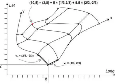
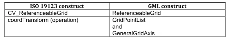
4.2.2
referenceable grid
grid associated with a transformation that can be used to convert grid coordinate values to values of coordinates
referenced to an external coordinate reference system
[ISO 19123]
10 Copyright © 2012 Open Geospatial Consortium
4.3 Symbols and abbreviated terms
In addition to the symbols and abbreviated terms listed in GML 3.2 (ISO 19136:2007), the following are used in this document:
LRS Linear Referencing System
5 Conventions
5.1 MIME media types
For exchanging GML instance documents over the internet, the media type "application/gml+xml" is used as specified by the OGC Technical Committee Policies and Procedures: MIME Media Types for GML.
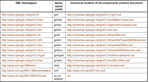
5.2 XML namespaces
The XML namespaces used within this standard are listed in Table 1. For each namespace, the namespace prefix used within this document and the canonical location of the all-components schema document are provided, too.
Table 1 — XML Namespaces
XML Namespace
Name-space prefix
Canonical location of all-components schema document
http://www.opengis.net/gml/3.2 gml http://schemas.opengis.net/gml/3.2.1/gml.xsd
http://www.opengis.net/gml/3.3/xbt gmlxbt http://schemas.opengis.net/gml/3.3/extdBasicTypes.xsd
http://www.opengis.net/gml/3.3/ce gmlce http://schemas.opengis.net/gml/3.3/geometryCompact.xsd
http://www.opengis.net/gml/3.3/tin gmltin http://schemas.opengis.net/gml/3.3/tin.xsd
http://www.opengis.net/gml/3.3/lr gmllr http://schemas.opengis.net/gml/3.3/linearRef.xsd
http://www.opengis.net/gml/3.3/lrtr gmllrtr http://schemas.opengis.net/gml/3.3/linearRefTowardsReferent.xsd
http://www.opengis.net/gml/3.3/lro gmllro http://schemas.opengis.net/gml/3.3/linearRefOffset.xsd
http://www.opengis.net/gml/3.3/lrov gmllrov http://schemas.opengis.net/gml/3.3/linearRefOffsetVector.xsd
http://www.opengis.net/gml/3.3/rgrid gmlrgrid http://schemas.opengis.net/gml/3.3/referencableGrid.xsd
http://www.opengis.net/gml/3.3/xer gmlexr http://schemas.opengis.net/gml/3.3/extdEncRule.xsd
http://www.w3.org/1999/xlink xlink http://schemas.opengis.net/xlink/1.0.0/xlinks.xsd
http://www.w3.org/XML/1998/namespace xml http://www.w3.org/2001/xml.xsd
http://www.w3.org/2001/XMLSchema xs (or default)
n/a
NOTE 1 A GML application schema conforming to this standard will import the GML 3.2 schema plus zero or more additional GML 3.3 schemas as needed.
EXAMPLE 1 The following GML application schema imports both the GML 3.2 schema and the GML 3.3 compact geometry encoding.
<schema
xmlns:gmlce="http://www.opengis.net/gml/3.3/ce"
NOTE 2 A GML instance conforming to this standard will directly or indirectly reference the GML 3.2 schema and zero or more additional GML 3.3 schemas as needed. A schema location attribute in the root element of the document has to include the schema of the namespace of the root element.
EXAMPLE 2 A sample instance for the GML application schema from example 1 as returned from a Web Feature Service. The GML schemas are imported by the GML application schema that is referenced from the instance document:
xsi:schemaLocation=" http://www.some.org/app http://www.some.org/app.xsd http://www.opengis.net/wfs/2.0 http://schemas.opengis.net/wfs/2.0/wfs.xsd"> <gml:posList>50 6 50 7 51 7 51 6</gml:posList>
</gmlce:SimplePolygon>
12 Copyright © 2012 Open Geospatial Consortium <!-- ... -->
</wfs:FeatureCollection>
5.3 Deprecated parts of previous versions of GML
The verb "deprecate" provides notice that the referenced portion is being retained for backwards compatibility with earlier versions but may be removed from or superseeded in this or a future version.
6 Additional basic types
6.1 Target namespace
All schema components specified in this Clause are in the target namespace:
http://www.opengis.net/gml/3.3/xbt
6.2 Localisable strings
6.2.1 LanguageStringTypeThe type gmlxbt:LanguageStringType adds an optional xml:lang attribute to xs:string. It is provided as a base type for linguistic text for use within the GML schemas and in GML application schemas.
<complexType name="LanguageStringType"> <simpleContent>
<extension base="xs:string"> <attribute ref="xml:lang"/> </extension>
</simpleContent> </complexType>
NOTE The name "LanguageStringType" was selected to align the naming with the equivalent type in the OWS Common standard.
6.2.2 Additional types based on LanguageStringType
The following types from GML 3.2 are defined in the http://www.opengis.net/gml/3.3/xbt schema with the same content model as in GML 3.2 with the exception that gmlxbt:LanguageStringType is used in place of xs:string:
- gml:CodeType,
- gml:CodeWithAuthorityType
In addition, the global property elements gmlxbt:description and gmlxbt:remarks have an optional xml:lang attribute in their content model. These elements are in the substitution group of the GML 3.2 property element with the same local name.
- gmlxbt:description
- gmlxbt:remarks.
6.3 TimePositionUnion
- gml:CalDate (union of xs:date, xs:gYearMonth and xs:gYear)
- xs:time
- xs:dateTime
- xs:anyURI
- xs:decimal
ISO 8601:2004 Clause 4.1.2 specifies the Calendar Date and its representations with reduced accuracy (i.e., YYYY-MM and YYYY). gml:CalDate is designed to support their encoding.
ISO 8601:2004 Clause 4.1.3 specifies the Ordinal Date, which is composed from the calendar year and the calendar day of the year (YYYY-DDD).
ISO 8601:2004 Clause 4.1.4 specifies the Week Date, which is composed from the calendar year, the calendar week and the calendar day of the week (YYYY-Www-D). Clause 4.1.4.3 specifies a Week Date representation with reduced accuracy that omits the day of the week component (YYYY-Www).
The ISO 8601:2004 Ordinal Date and Week Date with reduced accuracy are commonly used in some communities (for example, aviation) but are not supported by gml:TimePositionUnion. gmlxbt:TimePositionUnion is provided to accommodate representations of these sibling date-representations from ISO 8601:2004 by adding gmlxbt:OrdDate and gmlxbt:WeekDate to the union.
<simpleType name="TimePositionUnion">
<union memberTypes="gml:CalDate gmlxbt:OrdDate gmlxbt:WeekDate time dateTime anyURI decimal"/>
</simpleType>
<simpleType name="OrdDate"> <restriction base="string">
<pattern value="-?[0-9]{4}-[0-9]{3}"/> </restriction>
</simpleType>
<simpleType name="WeekDate"> <restriction base="string">
<pattern value=" -?[0-9]{4}-W(0[1-9]|[1-4][0-9]|5[0-3])(-[1-7])?"/> </restriction>
</simpleType>
The lexical space of gmlxbt:OrdDate consists of finite-length sequences of characters of the form
'-'? yyyy '-' ddd
where:
- '-'? yyyy is a four-or-more digit optionally negative-signed numeral that represents the year; if more than four digits, leading zeros are prohibited, and '0000' is prohibited (note that a plus sign is not permitted);
- the '-' is a separator between parts of the date;
- the ddd is a three-digit numeral that represents the calendar day of the year where the first calendar day of any calendar year is represented by '001' and subsequent calendar days are numbered in ascending sequence.
The lexical space of gmlxbt:WeekDate consists of finite-length sequences of characters of the form
14 Copyright © 2012 Open Geospatial Consortium where:
- '-'? yyyy is a four-or-more digit optionally negative-signed numeral that represents the year; if more than four digits, leading zeros are prohibited, and '0000' is prohibited (note that a plus sign is not permitted);
- the '-W' is a separator indicating that week-of-year follows;
- the ww is a two-digit numeral that represents the calendar week of the year where the first calendar week of any calendar year is represented by '01' and subsequent calendar weeks are numbered in ascending sequence;
- the '-' d (if present) is a one-digit numeral that represents the calendar day of the week where Monday shall be identified as calendar day '1' of any calendar week, and subsequent calendar days of the same calendar week shall be numbered in ascending sequence to Sunday (calendar day '7').
6.4 Requirements class
Requirements Classhttp://www.opengis.net/spec/GML/3.3/req/xbt Target type Data instance
Name Basic types (extensions)
Dependency http://www.opengis.net/doc/IS/GML/3.2/clause/2.4
Requirement http://www.opengis.net/spec/GML/3.3/req/xbt/valid
Any XML node whose content model is specified using schema components in the
http://www.opengis.net/gml/3.3/xbt schema SHALL be well-formed and valid.
Requirement http://www.opengis.net/spec/GML/3.3/req/xbt/iso8601
Any XML node whose content model is specified using gmlxbt:TimePositionUnit, gmlxbt:OrdDate or gmlxbt:WeekDate SHALL conform to ISO 8601:2004.
6.5 Conformance
Conformance Classhttp://www.opengis.net/spec/GML/3.3/conf/xbt
Requirements http://www.opengis.net/spec/GML/3.3/req/xbt Dependency http://www.opengis.net/doc/IS/GML/3.2/clause/2.4
Test http://www.opengis.net/spec/GML/3.3/conf/xbt/valid
Requirement http://www.opengis.net/spec/GML/3.3/req/xbt/valid
Test purpose Verify that any XML node whose content model is specified using schema components in the http://www.opengis.net/gml/3.3/xbt schema is well-formed and valid.
Test method Validate the XML document using the XML schema document
http://schemas.opengis.net/gml/3.3/extdBasicTypes.xsd. Pass if no errors reported. Fail otherwise.
Test type Basic
Requirement http://www.opengis.net/spec/GML/3.3/req/xbt/iso8601
Test purpose Verify that any XML node whose content model is specified using gmlxbt:TimePositionUnit conforms to ISO 8601:2004.
Test method Validate the XML document using the Schematron document
http://schemas.opengis.net/gml/3.3/iso8601.sch. Replace "{nodesOfTypeTimePositionUnion}" in the file with an Xpath expression to all nodes with a content model of gmlxbt:TimePositionUnit. Pass if no errors reported. Fail otherwise.
Test type Capability
7 Compact Encodings of Commonly Used GML Geometries
7.1 Target namespace
All schema components specified in this Clause are in the target namespace:
http://www.opengis.net/gml/3.3/ce
7.2 Introduction
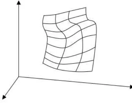
The simplified geometry encodings presented in this Clause conform to the spatial schema (ISO 19107), but are offered as compact encoding alternatives to some of the existing GML geometries specified in GML 3.2. The compact encodings follow the idea of the compact gml:LineString encoding, which represents a curve that is equivalent to the gml:Curve encoding restricted to the use of LineStringSegment elements as depicted in the following diagram.
7.3 SimplePolygon
16 Copyright © 2012 Open Geospatial Consortium NOTE The boundary of a gmlce:SimplePolygon is coplanar and the polygon uses planar interpolation in its interior.
The usage of the term 'simple' here refers to a specialized polygon with a simplified encoding, which is simply
connected (no interior rings) and uses a simple closed curve (no self-crossings) to represent its single boundary ring. The schema element declaration and corresponding type definition is as follows:
<element name="SimplePolygon" type="gmlce:SimplePolygonType"
substitutionGroup="gmlce:AbstractSimplePolygon"/>
<element name="AbstractSimplePolygon" type="gml:AbstractSurfaceType" substitutionGroup="gml:AbstractSurface"/>
<complexType name="SimplePolygonType"> <complexContent>
<extension base="gml:AbstractSurfaceType"> <sequence>
<choice>
<choice minOccurs="3" maxOccurs="unbounded"> <element ref="gml:pos"/>
<element ref="gml:pointProperty"/> </choice>
<element ref="gml:posList"/> </choice>
</sequence> </extension> </complexContent> </complexType>
The last coordinate does not have to repeat the first coordinate in this simplified encoding, so only three control points are required to specify a simple polygon. For this reason, the inner choice declaration above has the corresponding occurrence constraint minOccurs="3".
7.4 SimpleRectangle
NOTE The boundary of a gmlce:SimpleRectangle is coplanar and the polygon uses planar interpolation in its interior.
The schema element declaration and corresponding type definition is as follows:
<element name="SimpleRectangle" type="gmlce:SimpleRectangleType" substitutionGroup="gmlce:AbstractSimplePolygon"/>
<complexType name="SimpleRectangleType"> <complexContent>
<extension base="gml:AbstractSurfaceType"> <sequence>
<choice>
<choice minOccurs="4" maxOccurs="4"> <element ref="gml:pos"/>
<element ref="gml:pointProperty"/> </choice>
<element ref="gml:posList"/> </choice>
</sequence> </extension> </complexContent> </complexType>
7.5 SimpleTriangle
18 Copyright © 2012 Open Geospatial Consortium The schema element declaration and corresponding type definition is as follows:
<element name="SimpleTriangle" type="gmlce:SimpleTriangleType" substitutionGroup="gmlce:AbstractSimplePolygon"/>
<complexType name="SimpleTriangleType"> <complexContent>
<extension base="gml:AbstractSurfaceType"> <sequence>
<choice>
<choice minOccurs="3" maxOccurs="3"> <element ref="gml:pos"/>
<element ref="gml:pointProperty"/> </choice>
<element ref="gml:posList"/> </choice>
</sequence> </extension> </complexContent> </complexType>
EXAMPLE
<gmlce:SimpleTriangle gml:id="ID000"
srsName="http://www.opengis.net/def/crs/EPSG/0/4326"> <gml:posList>50 10 49 10 49.5 11</gml:posList>
</gmlce:SimpleTriangle>
7.6 SimpleArcString
A SimpleArcString is a specialized curve that has a simplified encoding of the logically equivalent GML 3.2 Curve with one or more GML 3.2 Arc segments. The schema element declaration and corresponding type definition is as follows:
<element name="SimpleArcString" type="gmlce:SimpleArcStringType" substitutionGroup="gmlce:AbstractSimpleArcString"/>
<element name="AbstractSimpleArcString" type="gml:AbstractCurveType" substitutionGroup="gml:AbstractCurve"/>
<complexType name="SimpleArcStringType"> <complexContent>
<sequence> <choice>
<choice minOccurs="3" maxOccurs="unbounded"> <element ref="gml:pos"/>
<element ref="gml:pointProperty"/> </choice>
<element ref="gml:posList"/> </choice>
</sequence>
<attribute name="interpolation" type="gml:CurveInterpolationType" fixed="circularArc3Points"/>
<attribute name="numArc" type="integer"/> </extension>
</complexContent> </complexType>
7.7 SimpleArc
A SimpleArc is a specialized curve that has a simplified encoding of the logically equivalent GML 3.2 Curve with a single GML 3.2 ArcString segment.
The schema element declaration and corresponding type definition is as follows:
<element name="SimpleArc" type="gmlce:SimpleArcType" substitutionGroup="gmlce:AbstractSimpleArcString"/>
<complexType name="SimpleArcType"> <complexContent>
<extension base="gml:AbstractCurveType"> <sequence>
<choice>
<choice minOccurs="3" maxOccurs="3"> <element ref="gml:pos"/>
<element ref="gml:pointProperty"/> </choice>
<element ref="gml:posList"/> </choice>
</sequence>
<attribute name="interpolation" type="gml:CurveInterpolationType" fixed="circularArc3Points"/>
<attribute name="numArc" type="integer" fixed="1"/> </extension>
20 Copyright © 2012 Open Geospatial Consortium
7.8 SimpleArcByCenterPoint
A SimpleArcByCenterPoint is a specialized curve that has a simplified encoding of the logically equivalent GML 3.2 Curve with a single GML 3.2 ArcByCenterPoint segment. As with the GML 3.2 ArcByCenterPoint, this representation can be used only in 2D. The schema element declaration and corresponding type definition is as follows:
<element name="SimpleArcByCenterPoint" type="gmlce:SimpleArcByCenterPointType" substitutionGroup="gmlce:AbstractSimpleArcString"/>
<complexType name="SimpleArcByCenterPointType"> <complexContent>
<extension base="gml:AbstractCurveType"> <sequence>
<element name="radius" type="gml:LengthType"/> <element name="startAngle" type="gml:AngleType"/> <element name="endAngle" type="gml:AngleType"/> </sequence>
<attribute name="interpolation" type="gml:CurveInterpolationType" fixed="circularArcCenterPointWithRadius"/>
<attribute name="numArc" type="integer" use="required" fixed="1"/> </extension>
</complexContent> </complexType>
NOTE Start and end angle are mandatory in this encoding unlike gml:ArcByCentrePoint.
7.9 SimpleArcStringByBulge
A SimpleArcStringByBulge is a specialized curve that has a simplified encoding of the logically equivalent GML 3.2 Curve with one or more GML 3.2 ArcByBulge segments. The schema element declaration and corresponding type definition is as follows:
<element name="SimpleArcStringByBulge" type="gmlce:SimpleArcStringByBulgeType" substitutionGroup="gmlce:AbstractSimpleArcString"/>
<complexType name="SimpleArcStringByBulgeType"> <complexContent>
<extension base="gml:AbstractCurveType"> <sequence>
<element name="bulge" type="double" maxOccurs="unbounded"/>
<element name="normal" type="gml:VectorType" maxOccurs="unbounded"/> </sequence>
fixed="circularArc2PointWithBulge"/>
<attribute name="numArc" type="integer"/> </extension>
</complexContent> </complexType>
7.10 SimpleArcByBulge
A SimpleArcStringByBulge is a specialized curve that has a simplified encoding of the logically equivalent GML 3.2 Curve with one GML 3.2 ArcByBulge segment. The schema element declaration and corresponding type definition is as follows:
<element name="SimpleArcByBulge" type="gmlce:SimpleArcByBulgeType" substitutionGroup="gmlce:AbstractSimpleArcString"/>
<complexType name="SimpleArcByBulgeType"> <complexContent>
<extension base="gml:AbstractCurveType"> <sequence>
<choice>
<choice minOccurs="2" maxOccurs="2"> <element ref="gml:pos"/>
<element ref="gml:pointProperty"/> </choice>
<element ref="gml:posList"/> </choice>
<element name="bulge" type="double" maxOccurs="unbounded"/>
<element name="normal" type="gml:VectorType" maxOccurs="unbounded"/> </sequence>
<attribute name="interpolation" type="gml:CurveInterpolationType" fixed="circularArc2PointWithBulge"/>
<attribute name="numArc" type="integer" fixed="1"/> </extension>
</complexContent> </complexType>
7.11 SimpleCircle
A SimpleCircle is a specialized curve that has a simplified encoding of the logically equivalent GML 3.2 Curve with a single GML 3.2 Circle segment.
22 Copyright © 2012 Open Geospatial Consortium The schema element declaration and corresponding type definition is as follows:
<element name="SimpleCircle" type="gmlce:SimpleArcType" substitutionGroup="gmlce:AbstractSimpleArcString"/>
7.12 SimpleCircleByCenterPoint
A SimpleCircleByCenterPoint is a specialized curve that has a simplified encoding of the logically equivalent GML 3.2 Curve with a single GML 3.2 CircleByCenterPoint segment. As with the GML 3.2 CircleByCenterPoint, this representation can be used only in 2D. The schema element declaration and corresponding type definition is as follows:
<element name="SimpleCircleByCenterPoint" type="gmlce:SimpleArcByCenterPointType"
substitutionGroup="gmlce:AbstractSimpleArcString"/>
Start and end angles are mandatory and should not be identical; they should differ by 360 degrees..
7.13 SimpleMultiPoint
gml:SimpleMultiPoint implements, and provides a simplified encoding for, ISO 19107 GM_MultiPoint (see ISO 19107:2003, 6.5.4). A gml:SimpleMultiPoint consists of a list of DirectPositions.
<complexType name="SimpleMultiPointType"> <complexContent>
<extension base="gml:AbstractGeometricAggregateType"> <sequence>
<element ref="gml:posList"/> </sequence>
</extension> </complexContent> </complexType>
<element name="SimpleMultiPoint" type="gmlce:SimpleMultiPointType" substitutionGroup="gml:AbstractGeometricAggregate" />
7.14 MultiPointPropertyType
A property that has a collection of points as its value domain may either be an appropriate geometry element encapsulated in an element of this type or an XLink reference to a remote geometry element (where remote includes geometry elements located elsewhere in the same document). The rules stated in GML 3.2, 7.2.3.4 apply.
<complexType name="MultiPointPropertyType"> <choice minOccurs="0">
<element ref="gml:MultiPoint"/>
<element ref="gmlce:SimpleMultiPoint"/> </choice>
7.15 Requirements class
Requirements Classhttp://www.opengis.net/spec/GML/3.3/req/ce Target type Data instance
Name Compact Geometry Encoding
Dependency http://www.opengis.net/doc/IS/GML/3.2/clause/2.4
Requirement http://www.opengis.net/spec/GML/3.3/req/ce/valid
Any XML node whose content model is specified using schema components in the
http://www.opengis.net/gml/3.3/ce schema SHALL be well-formed and valid.
7.16 Conformance
Conformance Classhttp://www.opengis.net/spec/GML/3.3/conf/ce
Requirements http://www.opengis.net/spec/GML/3.3/req/ce Dependency http://www.opengis.net/doc/IS/GML/3.2/clause/2.4
Test http://www.opengis.net/spec/GML/3.3/conf/ce/valid
Requirement http://www.opengis.net/spec/GML/3.3/req/ce/valid
Test purpose Verify that any XML node whose content model is specified using schema components in the http://www.opengis.net/gml/3.3/ce schema is well-formed and valid.
Test method Validate the XML document using the XML schema document
http://schemas.opengis.net/gml/3.3/geometryCompact.xsd. Pass if no errors reported. Fail otherwise.
Test type Basic
8 Triangulated Irregular Networks
8.1 Target namespace
All schema components specified in this Clause are in the target namespace:
http://www.opengis.net/gml/3.3/tin
8.2 Introduction
The support for Triangulated Irregular Networks (TIN) in GML 3.2 is consistent with the OGC Geometry Abstract Specification, ISO 19107:2003 Spatial schema and the OGC Simple Feature Common Architecture. However, three areas of concern of the TIN model in these standards are addressed by the new schema components to support typical civil engineering practice:
- Need for more robust set of "TIN elements"
- Need for a simpler triangle encoding
24 Copyright © 2012 Open Geospatial Consortium
8.3 TriangulatedSurface
<element name="TriangulatedSurface" type="gml:SurfaceType" substitutionGroup="gml:Surface"/>
gmltin:TriangulatedSurface implements ISO 19107 GM_TriangulatedSurface (see D.2.3.4 and ISO
19107:2003, 6.4.37).
A triangulated surface is a polyhedral surface that is composed only of triangles. There is no restriction on how the triangulation is derived.
gml:patches encapsulates the triangles of the triangulated surface. All patches shall be simple triangle patches.
gmltin:SimpleTrianglePatch is based upon the pattern used in the GML 3.3 SimpleTriangle, rather than the GML 3.2 Triangle.
A gmltin:SimpleTrianglePatch is a surface patch that is defined by a set of three points. The points shall be coplanar and the resultant simple triangle uses planar interpolation in its interior. The boundary of simple triangle patch can be obtained by constructing a gml:LinearRing, defined by four coordinate tuples representing the three points such that the first point is repeated as the last point, with linear interpolation between the points.
interpolation is fixed to "planar", i.e. an interpolation shall return points on a single plane. The boundary of the patch shall be contained within that plane.
8.5 TIN
<complexType name="TINType"> <complexContent>
<element name="tinElement" type="gmltin:TINElementPropertyType" minOccurs="0" maxOccurs="unbounded"/>
<element name="maxLength" type="gml:LengthType" minOccurs="0"/>
</sequence> </extension> </complexContent> </complexType>
<element name="TIN" type="gmltin:TINType"
substitutionGroup="gmltin:TriangulatedSurface"/>
gmltin:TIN is a triangulated surface that uses the Delaunay algorithm or a similar algorithm complemented with consideration of constraints defined by TIN Elements (gmltin:tinElements) and possibly a maximum length of triangle sides (gmltin:maxLength).
The set of the positions (three or more) used as posts for this TIN (corners of the triangles in the TIN) are specified either in TIN Element control points or group spots.
gmltin:TIN implements ISO/IEC 13249-3 ST_TIN (see ISO/IEC FCD 13249-3 8.6.1 ST_TIN Type) which extends ISO 19107 (see ISO 19136:2007 D.2.3.4 and ISO 19107:2003, 6.4.37).
8.6 TINElement
<complexType name="TINElementType"> <complexContent>
<extension base="gml:AbstractFeatureType"> <sequence>
<element name="elementType"
type="gmltin:TINElementTypeType"/>
<element name="elementID" type="integer" minOccurs="0"/> <element name="elementTag" type="string" minOccurs="0"/> <element name="elementGeometry"
type="gml:GeometryPropertyType"/> </sequence>
</extension> </complexContent> </complexType>
<element name="TINElement" type="gmltin:TINElementType" substitutionGroup="gml:AbstractObject"/>
gmltin:TINElement implements ISO/IEC 13249-3 ST_TINElement (see ISO/IEC FCD 13249-3 15.1.1 ST_TINElement Type). It specifies elements associated with a TIN which can be:
1) constraints (boundary, break line, soft break, control contour, break void, drape void, void, hole, stop line) applied to a TIN surface after the initial Delaunay triangulation which modify the surface,
2) points (random points, group spots) which are the vertices of simple triangles that define the TIN surface or vertices of constraints, or
3) user-defined.
26 Copyright © 2012 Open Geospatial Consortium The gmltin:elementID property allows for an optional integer value to numerically identify the TIN element.
The gmltin:elementTag property allows for an optional string value to alphanumerically identify the TIN element.
The gmltin:elementGeometry property specifies the geometry of the TIN element. The allowable geometry type is dependent upon the value of the gmltin:elementType:
- random points and group spot TIN elements shall have a 3D gml:MultiPoint geometry
- boundary, break void and void TIN elements shall have a 3D gml:Polygon geometry
- drape void and hole TIN elements shall have a 2D or 3D gml:Polygon geometry
- break line, soft break and control contour TIN elements shall have a 3D gml:LineString geometry
- stop line TIN elements shall have a 2D or 3D gml:LineString geometry
- for a user-defined TIN element, the choice of gml:GeometryPropertyType shall be user-defined.
8.7 TINElementPropertyType
A property that has a TIN element as its value domain may either be an appropriate TIN element encapsulated in an element of this type or an XLink reference to a remote TIN element (where remote includes TIN elements located elsewhere in the same document). Either the reference or the contained element shall be given, but neither both nor none.
</restriction> </simpleType> </union>
</simpleType>
gmltin:TINElementTypeType is a codelist which is the union of an enumeration of pre-defined TIN element types and a pattern for specifying a user-defined TIN type.
A TIN element of type ‘random points’ (gmltin:randomPoints) represents points on the surface of known elevation from which triangles can be generated or which represent linestring points contained in other TIN element geometries.
A TIN element of type ‘group spot’ (gmltin:groupSpot) represents a collection of related points on the surface of known elevation from which triangles can be generated or which represent linestring points contained in other TIN element geometries.
A TIN element of type ‘boundary’ (gmltin:boundary) is used to specify the boundary of the TIN surface. As a constraint applied to a TIN surface after the initial Delaunay triangulation, it causes the surface to be clipped to the boundary TIN element’s gml:Polygon geometry value. This may result in the elimination or addition of points contained in the initial random points or group spots TIN elements. It may also result in localized re-triangulation at the boundary. It is implementation-defined whether interior boundaries are supported.
A TIN element of type ‘breakline’ (gmltin:breakline) is used to represent a local ridge or depression in the TIN surface. When a breakline is specified for a TIN surface, simple triangle patches must be adjusted so that no triangle is crossed by the breakline. Part or all of the breakline becomes an edge of two or more triangles. The elevation along the breakline takes precedence over the elevation of the original triangulated surface for the entire length of the breakline.
A TIN element of type ‘soft break’ (gmltin:softBreak) behaves as a ‘breakline’ (see above) except that contour lines generated for the surface can be smoothed where they cross soft breaks.
A TIN element of type ‘control contour’ (gmltin:controlContour) behaves as a ‘breakline’ (see above). The z coordinate values must be identical for all points in the ‘control contour’ gml:LineString geometry. Triangles within the vicinity of a control contour need to be assessed during re-triangulation to insure that they are not zero slope triangles (all three vertices fall on the same control contour).
Voids enclose a voided area of the TIN surface. They can be represented by either break, drape or (regular) void types of TIN element. Void geometry is of type gml:Polygon, which might include interior boundaries. Triangles within a void still exist in the TIN surface but are considered to be void. Triangles inside of the gml:Polygon interior boundary are in the exterior of the gml:Polygon and therefore not in the void: these triangles are therefore not considered to be void.
For a void TIN element of type ‘break void’ (gmltin:breakVoid) the boundary linestrings (gml:LineString) of the 3D gml:Polygon behave as breaklines in that triangles in the simple triangle patch collection must be adjusted so that no triangle is crossed by the break void boundary. Part or all of the break void boundary becomes an edge of two or more triangles. The elevation of this break void boundary takes precedence over the elevation of the original triangulated surface for the entire length of the boundary.
For a void TIN element of type ‘drape void’ (gmltin:drapeVoid) the boundary linestrings (gml:LineString) of the 2D or 3D gml:Polygon behave as breaklines in that triangles in the simple triangle patch collection must be adjusted so that no triangle is crossed by the drape void boundary. Part or all of the drape void boundary becomes an edge of two or more triangles. However, for drape voids, the elevation of the original triangulated surface takes precedence over the elevation of the drape void boundary.
28 Copyright © 2012 Open Geospatial Consortium adjusted so that no triangle is crossed by the void boundary. Part or all of the void boundary becomes an edge of two or more triangles. However, for regular voids, only the elevations of the void boundary vertices take precedence over the elevation of corresponding points on the original surface. That is, these vertices are treated as points for triangulating. The regular void boundaries between these vertices are handled as drape void boundaries - elevations from the original surface take precedence.
A hole is an area of a TIN surface, defined by a 2D or 3D gml:Polygon, which is to be treated as a hole in the surface in that the triangles within this area still exist but are considered to be part of the hole. The difference between a void and a hole is realized when two TIN surfaces are merged. When merging TIN surface A with TIN surface B, a void in surface A will take precedence over what is in the same area in B, the result being retention of the voided A triangles. A hole in surface A results in that part of surface B showing through the hole and becoming part of the resultant merged surface. Though GML does not support merging of TINs, it is necessary to persist the distinction between voids and holes to make this information available to applications which do.
Hole boundaries are different than an interior boundary of a surface. The hole is still part of the interior of the surface since the triangles still exist. They are merely considered as being in the hole so applications know how to deal with them in a visibility context. This also allows for "islands" to exist inside the holes (if the hole polygon has interior rings): here the triangles exist and are not hole triangles. Had the triangles in the hole been eliminated, islands could not be supported in a single surface.
A TIN element of type ‘hole’ (gmltin:hole) encloses an area of the TIN surface designated as a hole. When a hole is specified for gmltin:TINElement, the boundary linestrings (gml:LineString) of the 2D or 3D gml:Polygon behave as breaklines in that triangles in the simple triangle patch collection must be adjusted so that no triangle is crossed by the hole boundary. Part or all of the hole boundary becomes an edge of two or more triangles. Hole boundaries are treated like drape void boundaries in that the elevation of the original triangulated surface takes precedence over the elevation of the hole boundary, if present.
A TIN element of type ‘stopLine’ (gmltin:stopLine) is used to specify areas where the local continuity or regularity of the TIN surface is questionable. It is implementation-defined whether triangles in the simple triangle patch collection whose boundaries are (2D) crossed by a stop line are removed from the collection of simple triangle patches or are retained but enclosed within a ‘drape void’ (gmltin:drapeVoid) type of
gmltin:TINElement.
8.9 Requirements class
Requirements Classhttp://www.opengis.net/spec/GML/3.3/req/tin Target type Data instance
Name Triangulated Irregular Networks
Dependency http://www.opengis.net/doc/IS/GML/3.2/clause/2.4
Requirement http://www.opengis.net/spec/GML/3.3/req/tin/valid
Any XML node whose content model is specified using schema components in the
http://www.opengis.net/gml/3.3/tin schema SHALL be well-formed and valid.
8.10 Conformance
Conformance Classhttp://www.opengis.net/spec/GML/3.3/conf/tin
Requirements http://www.opengis.net/spec/GML/3.3/req/tin Dependency http://www.opengis.net/doc/IS/GML/3.2/clause/2.4
Requirement http://www.opengis.net/spec/GML/3.3/req/tin/valid
Test purpose Verify that any XML node whose content model is specified using schema components in the http://www.opengis.net/gml/3.3/tin schema is well-formed and valid.
Test method Validate the XML document using the XML schema document
http://schemas.opengis.net/gml/3.3/tin.xsd. Pass if no errors reported. Fail otherwise.
Test type Basic
9 Linear Referencing
9.1 Target namespaces
Schema components specified in this Clause are in the following target namespaces, based on conformance class:
http://www.opengis.net/gml/3.3/lr - Basic linear referencing functionality
http://www.opengis.net/gml/3.3/lrtr - Towards referent extension; dependent upon gmllr
http://www.opengis.net/gml/3.3/lro - Offset extension; dependent upon gmllr
http://www.opengis.net/gml/3.3/lrov - Offset vector extension; dependent upon gmllr and gmllro
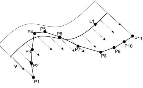
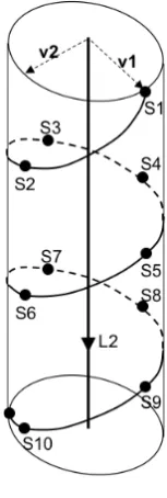
9.2 Introduction
GML 3.2 (and other OGC specifications) so far mainly support 2-D and 3-D spatial locations. An alternative location scheme is to use linearly referenced locations, where a location is specified as being at a certain distance along (and perhaps offset from) a linear element. The linear element might be a feature which exhibits linear behaviour (i.e., it is linearly measurable), a curve type of geometry, or a directed edge type of topology.
A significant amount of historical data is currently linearly referenced, especially in the transportation, piping, petroleum and mineral exploration industries. There are advantages of using this scheme over (or in addition to) spatial referencing.
Just as spatial data may utilize a variety of spatial (coordinate) reference systems, linearly referenced locations use a wide variety of Linear Referencing Methods (LRM). A well documented theoretical basis has been developed to support many of the more common LRMs in practice internationally today (ISO/DIS 19148 and OGC Abstract Specification Topic 19).
9.3 Basic Linear Referencing
9.3.1 Target namespaceAll schema components specified in this subclause are in the target namespace:
30 Copyright © 2012 Open Geospatial Consortium 9.3.2 Introduction
Basic Linear Referencing includes the specification of linearly referenced locations. These are described by a position expression which consists of the linear element being measured, the method of measurement and a measure value specified with a distance expression.
9.3.3 PositionExpression
gmllr:PositionExpression implements ISO 19148 LR_PositionExpression (see ISO/DIS 19148, 6.2.2).
A gmllr:PositionExpression specifies a position as a linearly referenced location given by the linear element being measured, the method of measurement and a measure value specified by a distance expression.
The element gmllr:linearElement specifies the linear element being measured.
The element gmllr:lrm specifies the linear referencing method of measurement.
The element gmllr:distanceExpression specifies the measured value.
9.3.4 PositionExpressionPropertyType
A property that has a position expression as its value domain may either be an appropriate position expression encapsulated in an element of this type or an XLink reference to a remote position expression (where remote includes position expressions located elsewhere in the same document). Either the reference or the contained element shall be given, but neither both nor none.
<element name="feature"
gmllr:LinearElement implements ISO 19148 LR_LinearElement (see ISO/DIS 19148, 6.2.3).
A gmllr:LinearElement specifies the underlying linear element upon which the measures in the Linear Referencing System are made. The linear element can be either a feature, a curve geometry or a topological edge.
The element gmllr:feature specifies that the linear element is a gml:AbstractFeature. gmllr:feature includes any feature as defined in ISO 19109:2005 7.3 which can be linearly measured.
The element gmllr:curve specifies that the linear element is a gml: AbstractCurve. gmllr:curve includes any one-dimensional geometry of type GM_Curve from ISO 19107:2003 6.3.16 which can be linearly measured. Spatial positions can be projected onto the gml:AbstractCurveto determine a corresponding linearly referenced location along the curve and vice versa.
The element gmllr:edge specifies that the linear element is a gml:DirectedEdge. gmllr:edge includes any one-dimensional topology of type TP_DirectedEdge from ISO 19107:2003 7.3.15 which can be linearly measured. Directed edges typically have one or more weights associated with them instead of having a length. Measuring along a directed edge therefore entails prorating a weight value. Consequently, the Linear Referencing Method of choice is typically of the interpolative type and unlikely to be of the relative type.
gmllr:defaultLRM implements the ISO 19148 LR_ILinearElement::defaultLRM() operation (see ISO/DIS 19148, 6.2.8.2).
The element gmllr:defaultLRM specifies the default Linear Referencing Method of the
gmllr:LinearElement. This is used for all measurements made along the gmllr:LinearElement
unless specified otherwise in a gmllr:PositionExpression or otherwise explicitly overridden.
gmllr:measure implements the ISO 19148 LR_ILinearElement::measure(measureAttribute) operation (see ISO/DIS 19148, 6.2.8.3).
The element gmllr:measure specifies the value of one of the measure attributes of the gmllr:LinearElement. This is usually one of its length attributes or, in the case of gmllr:edge, one of its weight attributes. Representing the overall length (or weight) of the gmllr:LinearElement, the gmllr:measure value is used for all calculations requiring the total linear element length, unless explicitly overridden, for example, when converting from an absolute to an interpolative Linear Referencing Method.
gmllr:startValue implements the ISO 19148 LR_ILinearElement::startValue(LRM) operation (see
32 Copyright © 2012 Open Geospatial Consortium The element gmllr:startValue specifies the measure value at the start of the gmllr:LinearElement for each appropriate Linear Referencing Method. If not provided, a default value of 0 (zero) is assumed for all Linear Referencing Methods.
A property that has a linear element as its value domain may either be an appropriate linear element encapsulated in an element of this type or an XLink reference to a remote linear element (where remote includes linear elements located elsewhere in the same document). Either the reference or the contained element shall be given, but neither both nor none.
9.3.7 StartValueType
<complexType name="StartValueType"> <simpleContent>
<extension base="double">
<attribute name="uom" type="gml:UomIdentifier"/> <attribute name="lrm" type="anyURI" use="required">
<annotation>
Because the start value is a function of the Linear Referencing Method, the gmllr:StartValueType extends a start value of type double with two attributes.
The optional attribute gmllr:uom provides the units of measure for the start value. If none is provided, the uom value defaults to the units value of the Linear Referencing Method.
The mandatory attribute gmllr:lrm specifies the Linear Referencing Method for which this start value applies. Though the type is anyURI, it is expected that the value will be a reference to an already defined
gmllr:LinearReferencingMethod object.
</sequence> </extension> </complexContent> </complexType>
<element name="LinearReferencingMethod" type="gmllr:LinearReferencingMethodType" substitutionGroup="gml:AbstractGML"/>
gmllr:LinearReferencingMethod implements ISO 19148 LR_LinearReferencingMethod (see ISO/DIS
19148, 6.2.10).
A gmllr:LinearReferencingMethod specifies the manner in which measurements are made along a
linear element.
The element gmllr:name specifies the name of the Linear Referencing Method, such as "kilometre-point". Allowable values are specified by the gmllr:LRMNameType codelist.
The element gmllr:type specifies the type of Linear Referencing Method. Allowable values are specified by the gmllr:LRMTypeType codelist.
The element gmllr:units specifies the units of measure used by the Linear Referencing Method as a gml:UomIdentifier. This applies to measurements made along the linear element.
The optional element gmllr:constraint allows for optional string values which specify any constraints imposed by the Linear Referencing Method.
9.3.9 LinearReferencingMethodPropertyType
<complexType name="LinearReferencingMethodPropertyType"> <sequence minOccurs="0">
<element ref="gmllr:LinearReferencingMethod"/> </sequence>
<attributeGroup ref="gml:AssociationAttributeGroup"/> </complexType>
A property that has a Linear Referencing Method as its value domain may either be an appropriate Linear Referencing Method encapsulated in an element of this type or an XLink reference to a remote Linear Referencing Method (where remote includes Linear Referencing Methods located elsewhere in the same document). Either the reference or the contained element shall be given, but neither both nor none.
9.3.10 DistanceExpressionType
<complexType name="DistanceExpressionType"> <complexContent>
<extension base="gml:AbstractGMLType"> <sequence>
<element name="distanceAlong" type="gmllr:MeasureType"/>
<element name="referent" type="gmllr:AlongReferentPropertyType" minOccurs="0"/>
</sequence> </extension> </complexContent> </complexType>
34 Copyright © 2012 Open Geospatial Consortium
gmllr:DistanceExpression implements ISO 19148 LR_DistanceExpression (see ISO/DIS 19148,
6.2.12).
A gmllr:DistanceExpression specifies the linear referenced measure value. This includes the distance measured along the linear element. If the Linear Referencing Method gmllr:LRMType is "relative", the distance expression also includes an along referent to specify where the measuring begins. Otherwise, measuring begins at the start of the linear element. Measuring is in the direction of the linear element, unless a towards referent is provided.
The element gmllr:distanceAlong specifies the measure value (usually a distance) of the distance expression. It is of type gmllr:MeasureType. gmllr:MeasureType is the same as gml:MeasureType except that the uom value is optional. If none is provided, the uom value defaults to the units value of the Linear Referencing Method.
If the Linear Referencing Method gmllr:type is ‘absolute’, the distance along is measured from the start of the linear element. If ‘relative’, it is measured from the along referent’s from referent. If ‘interpolative’, it is based upon the default length or weight of the linear element (gmllr:measure).
The optional element gmllr:referent specifies the referent associated with the distance expression
gmllr:distanceAlong value. A referent is only appropriate if the Linear Referencing Method
gmllr:type is "relative". If the referent is absent, then the position is measured from the start of the linear element.
A property that has a Distance Expression as its value domain may either be an appropriate Distance Expression encapsulated in an element of this type or an XLink reference to a remote Distance Expression (where remote includes Distance Expression located elsewhere in the same document). Either the reference or the contained element shall be given, but neither both nor none.
9.3.12 AlongReferent
gmllr:AlongReferent implements ISO 19148 LR_AlongReferent (see ISO/DIS 19148, 6.2.13).
The element gmllr:fromReferent specifies where along the gmllr:LinearElement measuring begins for the distance expression when the Linear Referencing Method is of type ‘relative’.
9.3.13 AlongReferentPropertyType
A property that has an along referent as its value domain may either be an appropriate along referent encapsulated in an element of this type or an XLink reference to a remote along referent (where remote includes along referents located elsewhere in the same document). Either the reference or the contained element shall be given, but neither both nor none.
9.3.14 Referent
gmllr:Referent implements ISO 19148 LR_Referent (see ISO/DIS 19148, 6.2.14).
For from and towards referents, gmllr:Referent is used to specify a known location along the gmllr:LinearElement. This can be a reference marker, an intersection, a jurisdictional boundary, or a landmark.
The element gmllr:name specifies the name of the referent, which is of type gml:CodeType to allow specification of the authority which created the name.
The element gmllr:type specifies the type of referent. Allowable values are specified by the gmllr:ReferentTypeType codelist.
The optional element gmllr:position specifies the spatial position of the referent, given in some coordinate reference system.