A GROUND MOVING TARGET EMERGENCY TRACKING METHOD FOR
CATASTROPHE RESCUE
Xiaoguang ZHOU, Daozhen LI, Guangqiang LI
School of Geosciences and Info-Physics, Central South University, Changsha 410083,China [email protected]
Technical Commission II
KEY WORDS: Catastrophe; Volunteer; Ground Moving Target; Emergency Tracking; Android
ABSTRACT:
In recent years, great disasters happen now and then. Disaster management test the emergency operation ability of the government and society all over the world. Immediately after the occurrence of a great disaster (e.g., earthquake), a massive nationwide rescue and relief operation need to be kicked off instantly. In order to improve the organizations efficiency of the emergency rescue, the organizers need to take charge of the information of the rescuer teams, including the real time location, the equipment with the team, the technical skills of the rescuers, and so on. One of the key factors for the success of emergency operations is the real time location of the rescuers dynamically. Real time tracking methods are used to track the professional rescuer teams now. But volunteers’ participation play more and more important roles in great disasters. However, real time tracking of the volunteers will cause many problems, e.g., privacy leakage, expensive data consumption, etc. These problems may reduce the enthusiasm of volunteers’ participation for catastrophe rescue. In fact, the great disaster is just small probability event, it is not necessary to track the volunteers (even rescuer teams) every time every day. In order to solve this problem, a ground moving target emergency tracking method for catastrophe rescue is presented in this paper. In this method, the handheld devices using GPS technology to provide the location of the users, e.g., smart phone, is used as the positioning equipment; an emergency tracking information database including the ID of the ground moving target (including the rescuer teams and volunteers), the communication number of the handheld devices with the moving target, and the usually living region, etc., is built in advance by registration; when catastrophe happens, the ground moving targets that living close to the disaster area will be filtered by the usually living region; then the activation short message will be sent to the selected ground moving target through the communication number of the handheld devices. The handheld devices receive and identify the activation short message, and send the current location information to the server. Therefore, the emergency tracking mode is triggered. The real time location of the filtered target can be shown on the organizer’s screen, and the organizer can assign the rescue tasks to the rescuer teams and volunteers based on their real time location. The ground moving target emergency tracking prototype system is implemented using Oracle 11g, Visual Studio 2010 C#, Android, SMS Modem, and Google Maps API.
1. INTRODUCTION
In recent years, great disasters happen now and then. Disaster management test the emergency operation ability of the government and society all over the world. Immediately after the occurrence of a great disaster (e.g., earthquake), a massive nationwide rescue and relief operation need to be kicked off instantly. In order to improve the organizations efficiency of the emergency rescue, the organizers need to take charge of the information of the rescuer teams, including the real time location, the equipment with the team, the technical skills of the rescuers, and so on. One of the key factors for the success of emergency operations is the real time location of the rescuers dynamically. Real time tracking methods are used to track the professional rescuer teams now. But volunteers’ participation play more and more important roles in great disasters, for examples, in Wenchuan earthquake (2008, China) and Haiti earthquake, many volunteers reported the security threats, e.g., road blocked, contaminated water, fire, etc.; available services, e.g., food distribution and shelter offered point, etc.; and other related information, e.g., vital lines etc. Furthermore, many volunteers took part in looking for the missing persons, treating wounded persons, distributing food,
and constructing shelters,etc. It in proved that the volunteers’ participation play more and more important roles in great disasters. But as the volunteers are not organized well, the real time location can not be tracked, the organizers can not take charge of the detailed information about the volunteers, e.g., the number of the volunteers in the disaster region, the real time location of the each volunteers, etc. That usually cause some volunteer rescuers even change to one need help. Therefore, it is necessary to track the volunteer rescuers in great disasters. However, real time tracking the volunteers will cause many problems, e.g., privacy leakage, expensive data consumption, etc. These problems may reduce the enthusiasm of volunteers’ participation for catastrophe rescue. In fact, the great disaster is just small probability event, it is not necessary to track the volunteers (even rescuer teams) every time every day. In order to solve this problem, a ground moving target emergency tracking method for catastrophe rescue is presented in this paper. In this method, the handheld devices using GPS technology to provide the location of the users, e.g., smart phone, is used as the positioning equipment; an emergency tracking information database is built in advance by registration; when catastrophe happens, the ground moving targets that living close to the disaster area will be filtered by the usually living region; then the activation short message will be sent to the selected ground The International Archives of the Photogrammetry, Remote Sensing and Spatial Information Sciences, Volume XL-2, 2014
moving target through the communication number of the handheld devices. The handheld devices receive and identify the activation short message, and send the current location information to the server. Therefore, the emergency tracking mode is triggered. The organizer can assign the rescue tasks to the rescuer teams and volunteers based on their real time location.
The remainder of the paper is structured as follows. In Section 2, we discuss the emergency tracking strategy for great disaster. The data organization of the emergency tracking information database is described in section 3. The implementation methods are discussed in section 4. An experimental test is presented in
Section 5. Section 6 provides a summary and concludes the discussion.
2. THE STRATEGY FOR EMERGENCY TRACKING
Real time tracking of the volunteers in great disasters may cause privacy leakage and big redundancy data transmit ion problems. In fact, the great disaster is just small probability event, it is not necessary to track the volunteers (even rescuer teams) every time every day. Based on this observation, a ground moving target emergency tracking method for catastrophe rescue is presented in this article. The strategy of this method is
· Selecting the volunteers Whose hometown in
Figure 1. The strategy for the emergency tracking in great disaster
1) Constructing the dynamic volunteer information database by registration through both web browsers and mobile cell phones in advance. The registration information includes the ID, name, cell phone number, home town (or living address, profession, education, age, sexuality, etc.
2) When a catastrophe happens, the disaster information inputting into the system, the buffer of the disaster region is generated at first.
3) The volunteers whose hometown (or living region) is in the buffer or has intersection region with the buffer is selected, and the request message for emergency tracking is sending to the selected volunteers via the mobile cell phone.
4) The mobile cell phone receive and identify the emergency tracking message, and send the real coordinate to the emergency rescue web sever.
5) The emergency rescue web sever receives the real coordinate
organizer can assign the rescue tasks to the helpful volunteers and trigger the emergency tracking.
3. THE DATA ORGANIZATION OF THE EMERGENCY TRACKING DATABASE
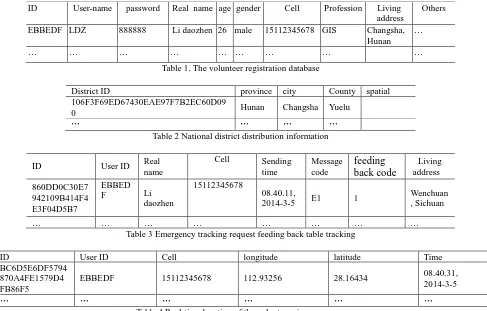
In order to kick off emergency tracking instantly after Catastrophe happen, an emergency tracking and national district distribution information databases are needed to be constructed in advance. In the emergency tracking database, the following is needed to be collected and stored at least (table 1), e.g., ID of the rescuer teams and volunteers, real name, cell phone number, living address, education, profession, tender, age, etc.; in the national district distribution information database, the national district spatial location and the responding names are collected and stored (table 2).
ID User-name password Real name age gender Cell Profession Living address
Others
EBBEDF LDZ 888888 Li daozhen 26 male 15112345678 GIS Changsha, Hunan
…
… … … …
Table 1. The volunteer registration database
District ID province city County spatial
106F3F69ED67430EAE97F7B2EC60D09
0 Hunan Changsha Yuelu
… … … …
Table 2 National district distribution information
ID User ID Real
name
Cell Sending time
Message code
feeding
back code
Living address
860DD0C30E7 942109B414F4 E3F04D5B7
EBBED
F Li
daozhen
15112345678
08.40.11,
2014-3-5 E1 1
Wenchuan , Sichuan
… … … …
Table 3 Emergency tracking request feeding back table tracking
ID User ID Cell longitude latitude Time
BC6D5E6DF5794 870A4FE1579D4 FB86F5
EBBEDF 15112345678 112.93256 28.16434 08.40.31,
2014-3-5
… … … …
Table 4 Real-time location of the volunteers in emergency
4.
EMERGENCY TRACKING
METHODOLOGY
The key issues for e
mergency tracking
include: 1) select
ingthe volunteers close to the disaster region
; 2)the
identification of the emergency tracking message
.1) Selecting the volunteers close to the disaster region
Catastrophe rescue usually is a nationwide emergency rescue action. There are volume information of the volunteers all over the country in the national volunteer emergency information database. In order to selecting the volunteers close to the disaster region effectively, we make the following measures: 1) When a volunteer registers to the emergency rescue system, he (or she ) is asked to input his or her home town (or common living address) name.
2) The national district information (including the spatial distribution, name, etc.) is collected and stored in the emergency rescue database.
3) When a catastrophe happens, the buffer of the disaster region is generated, the districts close to the disaster region will be computed by overlaying the buffer and the district distribution map,. Then the home town (or common living address)
information of the volunteers is used to filter the volunteers close to the disaster region.
2) The identification of the emergency tracking message
As the smart phone of the volunteers is multi-usage, it may receive several short messages one day. The catastrophe rescue requires the smart phone responses the emergency tracking message quickly. Thus, it is needed to identify the emergency tracking message automatically and fast. In order to solve this problem, we take two measures at the web sever side: the first one is using a SMS Modem with special communication number to send the emergency tracking message; the second one, special codes are assigned to the messages from the emergency recue web sever, e.g., E1 denotes the message asking the smart phone to upload the real position; E2 denotes the message asking whether the volunteer will take part in this emergency recue; E3 denotes the message of emergency recue task assigned by the organizers. Therefore, when the smart phone receive the message from the emergency recue web sever, it is easy to identify the tracking message and trigger the response operations.
The procedure for
emergency tracking
is shown in figure 2. The International Archives of the Photogrammetry, Remote Sensing and Spatial Information Sciences, Volume XL-2, 2014Catastrophe happen
Emergency tracking begin
Volunteer registration
database
National district
database Sending E1
message to the selected volunteers
Collect real-time location coordinates
feeding back
database Receive feeding
back information
Upload real-time location coordinates
Selecting the volunteers
close
Selecting the helpful volunteers
Sending E2 message to the helpful
volunteers
Mobile cells receive and identify E1 message
Mobile cells receive and identify E2 message
Real-time location
database
Agree to take part in the
rescue action
Begin emergency tracking
Receive real-time location
Yes End
No
… …
Web Sever
Mobile
Figure 2 the procedure for e
mergency tracking
5.
EXPERIMENTAL APPLICATION
To evaluate emergency tracking method, an emergency tracking prototype system is implemented using Oracle 11g, Visual Studio 2010 C#, Android, SMS Modem, and Google Maps API. Min and Zhang counties of Gansu province ( where a 6.6-magnitude earthquake was happened in in the morning, Jul. 22th 2013) are chosen to be the test disaster region. 50 volunteers are simulated both in Min and Zhang counties. It is assumed that 35 volunteers in Min county received and fed back
to the emergency tracking sever, and the other 15 ones did not response to the E1message; 25 volunteers in Zhang county received and fed back to the emergency tracking sever, and the other 25 ones did not response to the E1message; and there are 25 volunteers in Zhang county all answered “yes” to the E2 request. The emergency tracking result of Zhang county is shown in figure 3.
6.
CONCLUSION AND DISCUSSION
A ground moving target emergency tracking method for catastrophe rescue is presented in this paper. In this method, the handheld devices using GPS technology to provide the location of the users, e.g., smart phone, is used as the positioning equipment; an emergency tracking and national district distribution information databases are built in advance; when catastrophe happens, the ground moving targets that living close to the disaster area will be filtered by the usually living region; then the activation short message will be sent to the selected ground moving target through the communication number of the handled devices. The handheld devices receive and identify the activation short message, and send the current location information to the server. Therefore, the emergency tracking mode is triggered. The ground moving target emergency tracking prototype system is implemented and tested using both real and
simulated
data.Spatio-temporal modelling for the big trail data and automatic emergency rescue task allocation will be the
future work
.ACKNOWLEDGEMENTS
The work described in this article was supported by the National High Technology Research and Development Program of China (863 Program) under grant No. 2012AA121301, the National Natural Science Foundation of China under grant No. 41371366, and the National Key Technology R&D Program of China under grant No. 2012BAK12B01-2.
Reference
[1]Zook M., Graham M., Shelton T., et al. 2010. Volunteered Geographic Information and Crowdsourcing Disaster Relief: A Case Study of the Haitian Earthquake. World Medical & Health Policy 2(2): 7-33
[2]Roche S, Propeck-Zimmermann E, Mericskay B. 2013. GeoWeb and crisis management: issues and perspectives of volunteered geographic information [C]. GeoJournal,2013 (78):21-40.
[3]McDougall K, Temple-Watts P. The Use of Lidar and Volunteered Geographic Information to Map Flood Extents and Inundation[J]. ISPRS Annals of the Photogrammetry, Remote Sensing and Spatial Information Sciences, 2012, 1: 251-256. [4] Haklay M. How Good Is Volunteered Geographical Information? A Comparative Study of Openstreetmap and Ordnance Survey Datasets[J]. Environment and planning. B, Planning & design, 2010, 37(4): 682.
[5] Zielstra D, Zipf A. A Comparative Study of Proprietary Geodata and Volunteered Geographic Information for Germany[C]. 13th AGILE International Conference on Geographic Information Science.2010.