- DRAFT -
Komodo Marine Park Manta Rays: Acoustic Tagging Report
Pfleger Institute of Environmental Research (PIER), The Nature Conservancy (TNC) November 2001
In October of 2000 a pilot project was initiated to study the giant manta rays (Manta birostris) in Komodo Marine Park. This project embodies a collaboration between scientists from the Pfleger Institute of Environmental Research, The Nature Conservancy and rangers from the Komodo Marine Park. The goals of the project were several fold: 1) Adapt techniques to place acoustic tags on mantas in situ; 2) Characterize the movement patterns and habitat use in the park; 3) Determine whether mantas remain inside the park year round.
To achieve these goals a range of techniques were used including visual surveys, photo ID, and acoustic and satellite telemetry. Visual surveys were performed to
determine where the mantas were observed most frequently within the park and included observations from a boat as well as snorkeling and diving efforts. Two types of telemetry tags were used, acoustic and satellite. The acoustic tags were designed to track
movement within the park and the satellite tags were used to monitor movements of animals outside the park. Of these methods, this report will focus primarily on the acoustic tagging technique and preliminary results from this segment of the study.
Materials and methods
wing, near the point that the wing meets the body. To anchor the tags into the muscle, a medical grade plastic dart was used.
Table 1. Tagging date and location for the 23 mantas tagged with acoustic tags in the Komodo Marine Park. Also indicated is the last date the tag was detected and the stations where it was detected. T indicates the station it was tagged at and X indicates a station it was detected at.
Study sites for the acoustic receivers were chosen based on areas where mantas were commonly seen, which includes a range of habitats. Karang Makasar is near the northeast corner of Komodo Island and is characterized by a gradually slopping coral rubble field with a few isolated coral heads, away from any distinct structures. Manta Alley and German Flag are off of South Komodo in an area known as Loh Belanda. This area consists primarily of a series of small islands with a steep rocky shoreline generating a large degree of structure. German Flag is at the base of a large cliff in a channel
between Komodo and a smaller island. Manta Alley is a relatively small site (little more than a kilometer away from German Flag) along the northeast shore of a small rocky outcrop. Padar Kecil is along the southeastern corner of a small island, also at the base of a steep cliff (Figure 1).
Tag Date Tagging Last Karang S. Karang Tatawa Padar Manta Manta German Loh
ID Tagged Location Detection Makasar Makasar Kecil Kecil Alley Alley 2 Flag Dasami
1 Oct 16, 2000 Karang Makasar Oct, 16 2000 TX
2 Oct 16, 2000 Karang Makasar Jan 24, 2001 TX X
3 Oct 17, 2000 Karang Makasar Oct 17,2000 T X
4 Oct 16, 2000 Karang Makasar May 12, 2001 TX X 5 Oct 16, 2000 Karang Makasar Mar 27, 2001 TX X
6 Oct 19, 2000 German Flag Oct 22, 2000 X T
7 Oct 19, 2000 German Flag Mar 01, 2001 X X X T
8 Oct 19, 2000 German Flag Jan 25, 2001 X X X T
9 Apr 02, 2001 Karang Makasar Nov 04, 2001 TX 10 Apr 03, 2001 Karang Makasar May 04, 2001 TX 11 Apr 02, 2001 Karang Makasar Apr 02, 2001 TX
12 Apr 02, 2001 Karang Makasar Apr 06, 2001 TX X X
13 Apr 03, 2001 German Flag Sep 01, 2001 X X X T X
20 Apr 03, 2001 Karang Makasar Nov 07, 2001 TX X
21 Apr 03, 2001 German Flag Sep 11, 2001 X X T X
22 Apr 03, 2001 German Flag Oct 18, 2001 X X X T X
Figure 1. Map of acoustic receiver stations within Komodo Marine Park. The lines show movement of mantas between stations.
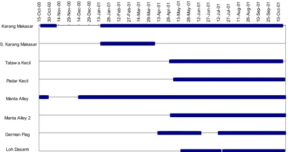
Acoustic receivers were initially set up at 2 stations around the park, Karang Makasar and Manta Alley. The receivers were secured to a line that was anchored to the bottom and suspended by a float. Both of these receivers were active for several weeks in October of 2000 until one was lost and the other was removed from the water and redeployed in December. Beginning in January, two additional receivers were deployed, and in April there were an additional five receivers used to cover a combination of seven stations within the park (Figures 1 and 2).
Karang Makasar
S. Karang Makasar
Tatawa Kecil
Padar Kecil Manta
Alley Manta Alley 2
German Flag
Figure 2. Timetable showing what stations had receivers between October 2000 and October 2001.
Results and Discussion
Over the past year, acoustically tagged mantas have been detected at six of the seven stations (all but Loh Dasami) (Table 2). Of the eight mantas that were tagged in October of 2000, none of these tags are still reporting and it is suspected that the tags came off the animals. For those 15 mantas tagged in April, there are still eight animals reporting.
Tagged mantas were primarily detected around the site of tagging, although some movement between sites is occuring. Animals that were tagged at Karang Makasar were detected at Tatawa Kecil, Padar Kecil, Manta Alley, Manta Alley 2 and German Flag. Mantas tagged at Manta Alley were detected at German Flag and Karang Makasar, and those tagged at German Flag were also detected at Manta Alley, Padar Kecil, Tatawa Kecil and Karang Makasar (Table 1).
The patterns of detection were fairly similar for both North Karang Makasar and South Makasar, which are separated by about 600 meters, and also for Manta Alley and
Manta Alley 2, which are about 80 meters apart. Although Manta Alley and German Flag are relatively close together (1.8 km) there were differences noted in the detections of tagged mantas.
Table 2. Table showing what tags were detected at each station during each month. The shaded areas indicate months where a receiver was not present at that station. The bold numbers indicate the last month that the tag was detected.
An analysis of detection against tides seems to show a potential correlation between the presence of mantas and the tidal fluctuations. For the month of April the tidal pattern was displayed with detections of mantas at Manta Alley, Karang Makasar and German Flag (Figure 3). Karang Makasar showed the strongest correlation between tagged manta detections and a strong rising tide. Tags 9, 10, 11, 12, 13, 17 and 20 were detected almost exclusively during the rising tides. German Flag also showed a strong correlation to the rising tide, although detections also occurred on the falling tide. For German Flag, data is available only for the last half of the month; the receiver was deployed here on April 13th. Manta Alley shows less of a tidal pattern, detections were made at this station on the rising as well as falling tides. These patterns correspond with visual observation
Oct 00 Nov 00 Dec 00 Jan 01 Feb 01 Mar 01 Apr 01 May 01 Jun 01 Jul 01 Aug 01 Sep 01 Oct 01 Karang 1,2,4,5,8 2,4,5,7 4,5,7 4,5,7 9,10,11, 9,10,15, 9,15,20 20 13,15,17, 9,15,19 9,15,19,
Makasar 12,13,17, 17,19,20 20 20
20
Manta 3,6,7,8 12,13,14, 13,18,19, 18,19 13,18,19 13 13 15,19,22,
Alley 15,16,18, 21,22 21,22 20
19,21,22
Manta 19 18,19,2213,18,19 13 15,19,22
Alley 2 22
German 13,14,15,4,13,14,15,13,18,19,13,15,18 13,18,21, 13,21,22 19,22
Flag 18,19,21, 16,18,19, 21,22 19,22 22
22,23 21,22,23
made in October of 2000 that noted that at Loh Belanda manta were commonly observed feeding at the surface during the falling tide when the current is predominantly east to west. It was also observed that Karang Makasar differed from Loh Belanda in that the mantas were more common when the tide was rising and currents were south to north, and while the tide was falling few or no individuals were observed.
Conclusions
It is clear from this study that mantas use the park year round. The remote
monitoring of mantas through the use of acoustic tags has already proven to be valuable. Prior to this study it was thought that mantas were absent from the park during certain times of the year; we have clearly shown them to be present year round. Although we know exactly where the tagged mantas are when they are near one of our hydrophone stations, we have no idea of their whereabouts when we are not picking them up at any station. A trend has been revealed for feeding at some stations during the incoming tide, but where do the mantas go on the falling tide? Do they go offshore to feed in the open ocean? These questions cannot be answered with our current methods.
The data up to this point has described some of the movement patterns for the mantas within the park. This has potential benefit in the establishment of ecotourism through the understanding of where the animals are found and how the tides influence this occurrence, as well as for environmental management plans. A closer examination of the tidal association at each station is still needed, as well as an attempt to show where the mantas are when they are not detected at the established stations, whether within or outside the park.
Recommendations
this may seem impossible, interviews with fishermen and other scientists may suggest a way to safely capture and handle these large fish.