Open Geospatial Consortium
Publication Date: 2014-05-28 Approval Date: 2014-01-14 Submission Date: 2013-06-26 External reference identifier: http://www.opengis.net/doc/IS/app_schema_profile/wcs_geotiff/1.0
Reference number of this document: OGC 12-100r1 Version: 1.0 Category: OGC® Implementation Standard Editor: Stephan Meissl
OGC® GML Application Schema - Coverages - GeoTIFF Coverage
Encoding Profile
Copyright © 2014 Open Geospatial Consortium.
To obtain additional rights of use, visit http://www.opengeospatial.org/legal/.
Warning
This document is an OGC Member approved international standard. This document is available on a royalty free, non-discriminatory basis. Recipients of this document are invited to submit, with their comments, notification of any relevant patent rights of which they are aware and to provide supporting documentation.
Document type: OGC® Encoding Standard
Document subtype: Application Schema Profile
Document stage: Approved
2 Copyright © 2014 Open Geospatial Consortium.
License Agreement
Permission is hereby granted by the Open Geospatial Consortium, ("Licensor"), free of charge and subject to the terms set forth below, to any person obtaining a copy of this Intellectual Property and any associated documentation, to deal in the Intellectual Property without restriction (except as set forth below), including without limitation the rights to implement, use, copy, modify, merge, publish, distribute, and/or sublicense copies of the Intellectual Property, and to permit persons to whom the Intellectual Property is furnished to do so, provided that all copyright notices on the intellectual property are retained intact and that each person to whom the Intellectual Property is furnished agrees to the terms of this Agreement.
If you modify the Intellectual Property, all copies of the modified Intellectual Property must include, in addition to the above copyright notice, a notice that the Intellectual Property includes modifications that have not been approved or adopted by LICENSOR.
THIS LICENSE IS A COPYRIGHT LICENSE ONLY, AND DOES NOT CONVEY ANY RIGHTS UNDER ANY PATENTS THAT MAY BE IN FORCE ANYWHERE IN THE WORLD.
THE INTELLECTUAL PROPERTY IS PROVIDED "AS IS", WITHOUT WARRANTY OF ANY KIND, EXPRESS OR IMPLIED, INCLUDING BUT NOT LIMITED TO THE WARRANTIES OF MERCHANTABILITY, FITNESS FOR A PARTICULAR PURPOSE, AND NONINFRINGEMENT OF THIRD PARTY RIGHTS. THE COPYRIGHT HOLDER OR HOLDERS INCLUDED IN THIS NOTICE DO NOT WARRANT THAT THE FUNCTIONS CONTAINED IN THE INTELLECTUAL PROPERTY WILL MEET YOUR REQUIREMENTS OR THAT THE OPERATION OF THE INTELLECTUAL PROPERTY WILL BE
UNINTERRUPTED OR ERROR FREE. ANY USE OF THE INTELLECTUAL PROPERTY SHALL BE MADE ENTIRELY AT THE USER’S OWN RISK. IN NO EVENT SHALL THE COPYRIGHT HOLDER OR ANY CONTRIBUTOR OF
INTELLECTUAL PROPERTY RIGHTS TO THE INTELLECTUAL PROPERTY BE LIABLE FOR ANY CLAIM, OR ANY DIRECT, SPECIAL, INDIRECT OR CONSEQUENTIAL DAMAGES, OR ANY DAMAGES WHATSOEVER RESULTING FROM ANY ALLEGED INFRINGEMENT OR ANY LOSS OF USE, DATA OR PROFITS, WHETHER IN AN ACTION OF CONTRACT, NEGLIGENCE OR UNDER ANY OTHER LEGAL THEORY, ARISING OUT OF OR IN CONNECTION WITH THE IMPLEMENTATION, USE, COMMERCIALIZATION OR PERFORMANCE OF THIS INTELLECTUAL PROPERTY.
This license is effective until terminated. You may terminate it at any time by destroying the Intellectual Property together with all copies in any form. The license will also terminate if you fail to comply with any term or condition of this Agreement. Except as provided in the following sentence, no such termination of this license shall require the termination of any third party end-user sublicense to the Intellectual Property which is in force as of the date of notice of such termination. In addition, should the Intellectual Property, or the operation of the Intellectual Property, infringe, or in LICENSOR’s sole opinion be likely to infringe, any patent, copyright, trademark or other right of a third party, you agree that LICENSOR, in its sole discretion, may terminate this license without any compensation or liability to you, your licensees or any other party. You agree upon termination of any kind to destroy or cause to be destroyed the Intellectual Property together with all copies in any form, whether held by you or by any third party.
Except as contained in this notice, the name of LICENSOR or of any other holder of a copyright in all or part of the Intellectual Property shall not be used in advertising or otherwise to promote the sale, use or other dealings in this Intellectual Property without prior written authorization of LICENSOR or such copyright holder. LICENSOR is and shall at all times be the sole entity that may authorize you or any third party to use certification marks, trademarks or other special designations to indicate compliance with any LICENSOR standards or specifications.
Contents
Page1 Scope ... 8
2 Conformance ... 8
3 Normative references ... 8
4 Terms and definitions (normative) ... 9
4.1 raster or image space ... 9
4.2 model space ... 9
5 Overview and conventions ... 9
5.1 Overview (informative) ... 9
5.2 Namespace prefix conventions ... 10
5.3 Multiple representations ... 10
6 GeoTIFF coverage representation requirements class ... 10
6.1 General ... 11
6.2 GeoTIFF identification ... 11
6.3 Mapping between GeoTIFF abstract model and GML AS abstract model ... 12
6.3.1 Domain ... 12
6.3.2 Range ... 15
6.4 GeoTIFF parameters ... 15
6.4.1 Request ... 15
6.4.2 Response ... 17
6.4.3 Exceptions ... 18
Annex A (normative) Abstract Test Suite ... 19
Annex B (informative) Resources ... 27
B.1 Links ... 27
B.2 Examples ... 27
4 Copyright © 2014 Open Geospatial Consortium.
Figures
PageFigure 1: Relation between raster or pixel and model space in case of PixelIsArea . 15
Tables
PageTable 1 – Namespace mappings ... 10
Table 2 – Parameters for requesting GeoTIFF encoded coverages ... 16
i.
Abstract
This Interface Standard is a profile of the OGC® GML Application Schema –Coverages version 1.0 [OC 09-146r2]. This document specifies the usage of the GeoTIFF data format for the encoding of GML coverages. This encoding is used by several OGC services like the Web Coverage Service (WCS) 2.0 Interface Standard – Core [OGC 09-110r4].
ii.
Keywords
ogcdoc, wcs, geotiff
iii.
Document terms and definitions
This document uses the standard terms defined in Subclause 5.3 of [OGC 06-121r9], which is based on the ISO/IEC Directives, Part 2. Rules for the structure and drafting of International Standards. In particular, the word “shall” (not “must”) is the verb form used to indicate a requirement to be strictly followed to conform to this standard.
iv.
Document contributor contact points
All questions regarding this document should be directed to the editor or the contributors:
Name Organization
Stephan Meissl EOX IT Services GmbH, Austria, stephan.meissl<at>eox.at
Christian Schiller EOX IT Services GmbH, Austria, christian.schiller<at>eox.at
Peter Baumann Jacobs University Bremen / rasdaman GmbH, p.baumann<at>jacobs-university.de
v.
Changes to the OGC Abstract Specification
The OGC® Abstract Specification does not require any changes to accommodate the technical contents of this document.
vi.
Forward
Attention is drawn to the possibility that some of the elements of this document may be the subject of patent rights. The Open Geospatial Consortium shall not be held
responsible for identifying any or all such patent rights.
6 Copyright © 2014 Open Geospatial Consortium.
aware that might be infringed by any implementation of the standard set forth in this document, and to provide supporting documentation.
Suggested additions, changes, and comments on this draft standard are welcome and encouraged. Such suggestions may be submitted by email message to OGC or by making suggested changes in an edited copy of this document and submitting this document to OGC.
vii.
Future work
It is foreseen to adapt and expand the support of coverages of type
Introduction
Coverages represent digital geospatial information representing space/time-varying phenomena. OGC Abstract Topic 6 [OGC 07-011] – which is identical to ISO 19123 – defines an abstract model of coverages. Coverage instances may be encoded using the GML Application Schema – Coverages (GMLCOV) version 1.0 [OGC 09-146r2] which is based on the Geography Markup Language (GML) version 3.2 [OGC 07-036], an XML grammar written in XML Schema for the description of application schemas as well as the transport and storage of geographic information.
This profile of GMLCOV specifies the usage of the GeoTIFF data format for the encoding of GML coverages. It is based on the authoritative format specification available as GeoTIFF Format Specification which in turn is based on the TIFF specification.
8 Copyright © 2014 Open Geospatial Consortium.
OGC® GML Application Schema - Coverages - GeoTIFF
Coverage Encoding Profile
1 Scope
This OGC® GML Application Schema - Coverages - GeoTIFF Coverage Encoding Profile – henceforth abbreviated as “GMLCOV for GeoTIFF” specifies an encoding of coverages in the GeoTIFF data exchange format.
2 Conformance
This document establishes the following requirements and conformance class:
geotiff-coverage, of URI http://www.opengis.net/spec/GMLCOV_geotiff-coverages/1.0/req/geotiff-coverage, with a single pertaining conformance class, geotiff-coverage, of URI http://www.opengis.net/spec/GMLCOV_geotiff-coverages/1.0/conf/geotiff-coverage.
Standardization target of all conformance classes are concrete coverage instance documents, as generated by some service and/or consumed by some client.
URIs given in this document for each requirement or conformance test URIs are relative paths to be appended to the root
http://www.opengis.net/spec/GMLCOV_geotiff-coverages/1.0.
Annex A lists the conformance tests which shall be exercised on any software artifact claiming to implement GMLCOV for GeoTIFF.
3 Normative references
This GMLCOV for GeoTIFFspecification consists of the present document and an XML Schema. The complete specification is identified by OGC URI
http://www.opengis.net/spec/GMLCOV_geotiff-coverages/1.0, the document has OGC URI http://www.opengis.net/doc/ISx/GMLCOV_geotiff-coverages/1.0.
The complete specification is available for download from
http://www.opengeospatial.org/standards/gmlcov; additionally, the XML Schema is posted online at http://schemas.opengis.net/gmlcov/geotiff/1.0 as part of the OGC schema repository. In the event of a discrepancy between bundled and schema repository versions of the XML Schema files, the schema repository shall be considered authoritative.
OGC 09-146r2, OGC® GML Application Schema – Coverages, version 1.0
Conformance classes used:
gml-coverage
multipart
special-format
OGC 07-036, OpenGIS® Geography Markup Language (GML) Encoding Standard, version 3.2
GeoTIFF, GeoTIFF Format Specification , version 1.8.2, supporting GeoTIFF Revision 1.0 Final, 2000-12-28, available at
http://www.remotesensing.org/geotiff/spec/geotiffhome.html [2011-06-17] TIFF, TIFF, revision 6.0 Final, 1992-06-03, available at
ftp://ftp.remotesensing.org/geotiff/spec/tiff6.pdf [2011-06-17]
TIFF-TN2, DRAFT TIFF Technical Note #2, 1995-03-17, available at http://www.remotesensing.org/libtiff/TIFFTechNote2.html [2013-06-26] TIFF-TN, Adobe Photoshop® TIFF Technical Notes, 2002-03-22, available at http://partners.adobe.com/public/developer/en/tiff/TIFFphotoshop.pdf [2013-06-26] TIFF-TN3, Adobe Photoshop® TIFF Technical Note 3, 2005-04-08, available at http://chriscox.org/TIFFTN3d1.pdf [2013-06-26]
RFC-3302, RFC 3302, Tag Image File Format (TIFF) - image/tiff MIME Sub-type Registration, 2002-09, available at http://tools.ietf.org/html/rfc3302 [2011-06-17]
4 Terms and definitions (normative)
For the purposes of this document, the terms and definitions given in the above references (in particular: GML AS – Coverages [OGC 09-146r2]) apply.
4.1 raster or image space
Space used to reference the pixel values in a grid or image (cf. GeoTIFF format specification [GeoTIFF]).
4.2 model space
Space used to reference points on the earth (cf. GeoTIFF format specification [GeoTIFF]).
5 Overview and conventions
5.1 Overview (informative)
10 Copyright © 2014 Open Geospatial Consortium.
so the GeoTIFF format is fully compliant with the TIFF format. Thus software incapable of reading and interpreting these extension TIFF tags is still able to open a GeoTIFF format file by simply ignoring them.
A TIFF file is composed of the Image File Header (IFH) and one or multiple Image File Directories (IFDs) holding the actual data entries in 2D rectangular arrays of pixels.
Thus, the only coverage types supported by this specification are
gmlcov:GridCoverage, gmlcov:RectifiedGridCoverage,
gmlcov:ReferenceableGridCoverage, and any coverage type derived thereof with exactly 2 dimensions. Although techniques to store 3D or even higher dimensional coverages in TIFF files are known they are not considered herein.
For coverages of type gmlcov:GridCoverage the GeoTIFF format specification is not needed and simple TIFF files are used instead. However, this profile still applies.
Following the notation of the abstract coverage definition in the GML AS – Coverages [OGC 09-146r2] the domainSet is limited to 2 dimensions and the rangeType is limited according to the TIFF specification.
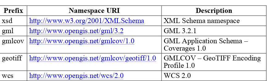
5.2 Namespace prefix conventions
The following namespaces are used in this document. The prefix abbreviations used constitute conventions used here, but are not normative. The namespaces to which the prefixes refer are normative, however.
Table 1 – Namespace mappings
Prefix Namespace URI Description
xsd http://www.w3.org/2001/XMLSchema XML Schema namespace
gml http://www.opengis.net/gml/3.2 GML 3.2.1
gmlcov http://www.opengis.net/gmlcov/1.0 GML Application Schema – Coverages 1.0
geotiff http://www.opengis.net/gmlcov/geotiff/1.0 GMLCOV – GeoTIFF Encoding Profile 1.0
wcs http://www.opengis.net/wcs/2.0 WCS 2.0
5.3 Multiple representations
When multiple representations of the same information are given in a specification
document these are consistent. Should this not be the case then this is considered an error, and the XML schema shall take precedence.
6 GeoTIFF coverage representation requirements class
a WCS by defining parameters for TIFF features like compression, tiling, etc. Its identifying URL is given by http://www.opengis.net/spec/GMLCOV_geotiff-coverages/1.0/req/geotiff-coverage.
6.1 General
Coverages using GeoTIFF encoding shall follow both the TIFF and the GeoTIFF specifications.
Requirement 1 /req/geotiff-coverage/tiff-specification:
A GeoTIFF encoded coverage instance shall follow the TIFF specification [TIFF].
Note GeoTIFF encoded coverage instances may additionally follow one or more of the TIFF extensions [BigTIFF], [TIFF-TN2], [TIFF-TN], or [TIFF-TN3].
Requirement 2 /req/geotiff-coverage/type:
A GeoTIFF encoded coverage instance shall be of type gmlcov:GridCoverage, gmlcov:RectifiedGridCoverage, or gmlcov:ReferenceableGridCoverage, or a subtype thereof.
Dependency: http://www.opengis.net/spec/GMLCOV/1.0/conf/gml-coverage
Requirement 3 /req/geotiff-coverage/geotiff-specification: A GeoTIFF encoded coverage instance and being of type
gmlcov:RectifiedGridCoverage, or gmlcov:ReferenceableGridCoverage, or a subtype thereof shall follow the GeoTIFF specification [GeoTIFF] and shall contain the geo-referencing information of the coverage.
Note Coverages with type gmlcov:GridCoverage only need to adhere to the TIFF specification.
6.2 GeoTIFF identification
The GeoTIFF format shall be identified by the following URI or MIME type identifier, whenever a format identifier is required.
Note Extensive examples are available online at the same place as the accompanying XML schemas.
Requirement 4 /req/geotiff-coverage/uri:
If the usage of URIs is possible GeoTIFF encoding of a coverage shall be indicated by the following URI:
http://www.opengis.net/spec/GMLCOV_geotiff-coverages/1.0/conf/geotiff-coverage
Note Examples include the value of the xlink:role attribute of the
gml:rangeParameters element in multipart GML coverage instances, or the ows:Profile
element in WCS GetCapabilities responses.
Requirement 5 /req/geotiff-coverage/mime-type-identifier:
12 Copyright © 2014 Open Geospatial Consortium.
identifier:
image/tiff
Note MIME sub-type image/tiff is defined in [RFC-3302].
Note Examples include the value of the Content-Type header in service responses, the
formatSupported element in WCS GetCapabilities responses, the nativeFormat element in WCS DescribeCoverage responses, or the format parameter in WCS GetCoverage requests.
6.3 Mapping between GeoTIFF abstract model and GML AS abstract model
6.3.1 Domain
Requirement 6 /req/geotiff-coverage/dimensions:
The domain of a GeoTIFF encoded coverage instance shall have exactly 2 dimensions.
Requirement 7 /req/geotiff-coverage/crs:
The coordinate reference system identified by the value of the srsName attribute of the
gml:Envelope element of the gml:boundedBy element of a GeoTIFF encoded coverage instance shall be the same as the coordinate reference system used in the GeoTIFF part.
Note The value of the srsName attribute of the Envelope element shall be inherited by all directly expressed geometries (see GML 3.2 [OGC 07-036] clause 9.10), i.e. for all range set values encoded in GeoTIFF.
Note “The coordinate reference system used in the GeoTIFF part” depends on the coverage’s type. For the type gmlcov:RectifiedGridCoverage this is obvious, for the type
gmlcov:ReferenceableGridCoverage this is the coordinate reference system used for the tiepoints, and finally for the type gmlcov:GridCoverage the coordinate reference system is limited to raster or image space ones anyway and thus “the GeoTIFF part” is in fact a pure TIFF part only.
Note GML 3.2 [OGC 07-036] does not define any concrete ReferenceableGrid and the ones added by Change Request OGC 07-112r3 are not suitable for usage with GeoTIFF encoding. Thus a new suitable one, e.g. ReferenceableGridByGCPs, is going to be proposed but will only be available in future.
Requirement 8 /req/geotiff-coverage/axis-ordering:
The value ordering of a GeoTIFF encoded coverage instance shall adhere to the axis order of the coordinate reference system identified by the value of the srsName attribute of the gml:Envelope element of the gml:boundedBy element.
Note This applies to all elements directly bound to a coordinate reference system i.e. the
boundedBy, origin, and offsetVector elements but not to elements in raster or image space i.e. the grid.
Requirement 9 /req/geotiff-coverage/pixel-is-area:
The domain of a GeoTIFF encoded coverage instance shall respect the coverage’s raster space as defined in the GeoTIFF specification [GeoTIFF] i.e. PixelIsArea or
Note The definition of grids in GML 3.2 [OGC 07-036] clause 19.2.2 which GMLCOV is based on reads as: “When a grid point is used to represent a sample space (e.g. image pixel), the grid point represents the center of the sample space (see ISO 19123:2005, 8.2.2).”.
Note GMLCOV does not store the raster type i.e. PixelIsArea or PixelIsPoint
information in its current version. However, Requirement 9 above specifies that the
gml:boundedBy element shall respect the raster type i.e. it shall include the half pixel border in case of PixelIsArea (see also Figure 1) but not in case of PixelIsPoint. In other words, in case of PixelIsArea the gml:boundedBy element is decreased by the half of both
gml:offsetVector elements in the gml:lowerCorner coordinate and increased by the half of both gml:offsetVector elements in the gml:upperCorner coordinate compared to the case of PixelIsPoint. The gml:origin element stays the same independently of the raster space.
Examples: The following XML fragments show the boundedBy and the domainSet elements describing the domain of sample coverages respecting the axis ordering of the used CRS:
Default axis order (easting, northing) using PixelIsArea:
<gml:boundedBy>
<gml:Envelope srsName="http://www.opengis.net/def/crs/EPSG/0/3857"
axisLabels="x y" uomLabels="m m" srsDimension="2">
<gml:lowerCorner>100 50</gml:lowerCorner>
<gml:upperCorner>500 350</gml:upperCorner>
</gml:Envelope> </gml:boundedBy> <gml:domainSet>
<gml:RectifiedGrid dimension="2" gml:id="grid_grey">
<gml:limits>
<gml:axisLabels>x y</gml:axisLabels>
<gml:origin>
<gml:offsetVector srsName="http://www.opengis.net/def/crs/EPSG/
0/3857">10 0</gml:offsetVector>
<gml:offsetVector srsName="http://www.opengis.net/def/crs/EPSG/
0/3857">0 -10</gml:offsetVector>
</gml:RectifiedGrid> </gml:domainSet>
Default axis order using PixelIsPoint:
<gml:boundedBy>
<gml:Envelope srsName="http://www.opengis.net/def/crs/EPSG/0/3857"
axisLabels="x y" uomLabels="m m" srsDimension="2">
<gml:lowerCorner>105 55</gml:lowerCorner>
<gml:upperCorner>495 345</gml:upperCorner>
14 Copyright © 2014 Open Geospatial Consortium.
<gml:domainSet>
... (same as above)
</gml:domainSet>
Reversed axis order (latitude, longitude) using PixelIsArea:
<gml:boundedBy>
<gml:Envelope srsName="http://www.opengis.net/def/crs/EPSG/0/4326"
axisLabels="lat long" uomLabels="deg deg" srsDimension="2">
<gml:lowerCorner>
0.000449157641044 0.00089831528412 </gml:lowerCorner>
<gml:upperCorner>
0.003144103492834 0.00449157641984 </gml:upperCorner>
</gml:Envelope> </gml:boundedBy> <gml:domainSet>
<gml:RectifiedGrid dimension="2" gml:id="grid_grey">
<gml:limits>
<gml:GridEnvelope>
<gml:low>0 0</gml:low>
<gml:high>39 29</gml:high>
</gml:GridEnvelope>
</gml:limits>
<gml:axisLabels>lat long</gml:axisLabels>
<gml:origin>
<gml:Point gml:id="grid_origin_grey"
srsName="http://www.opengis.net/def/crs/EPSG/0/4326">
<gml:pos>0.0030991877286375 0.0009432310483165</gml:pos>
</gml:Point>
</gml:origin>
<gml:offsetVector srsName="http://www.opengis.net/def/crs/EPSG/
0/4326">0 0.000089831528393</gml:offsetVector>
<gml:offsetVector srsName="http://www.opengis.net/def/crs/EPSG/
0/4326">-0.000089831528393 0</gml:offsetVector>
</gml:RectifiedGrid> </gml:domainSet>
Note The complete examples corresponding to the XML fragments given above including GeoTIFF files are available online at the same place as the accompanying XML schemas.
100 110 | 0 | |
350-- +---+---+---+ ... +---+
0--| * | * | * | | * |
340-- +---+---+---+ +---+
| * | * | * | | * | +---+---+---+ +---+ ...
+---+---+---+ +---+ | * | * | * | | * |--29 +---+---+---+ +---+ --50 |
39 | 500
Figure 1: Relation between raster or pixel and model space in case of PixelIsArea
6.3.2 Range
Requirement 10 /req/geotiff-coverage/range-ordering:
A GeoTIFF encoded coverage instance with more than one component in the rangeType shall order the components of the coverage’s rangeType in the same order as given in the
gml:rangeType element’s document order.
Note The order of components, also called bands, within a composite rangeSet value corresponds to document order of the rangeType elements.
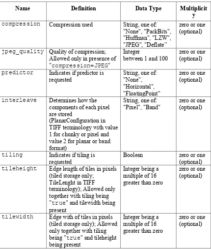
6.4 GeoTIFF parameters
6.4.1 Request
The following GeoTIFF parameters are defined for requesting GeoTIFF encoded coverages for example via WCS GetCoverage requests.
Note It is always possible for a given coverage instance to determine its current parameter values, i.e., the parameter values used at creation. Thus a GeoTIFF encoded coverage is self-describing.
Requirement 11 /req/geotiff-coverage/parameters-xml:
The structure of an XML request requesting a GeoTIFF encoded coverage instance shall be extended as defined in Table 2 and the respective XML Schema being part of this standard.
Requirement 12 /req/geotiff-coverage/parameters-kvp:
The structure of a KVP request requesting a GeoTIFF encoded coverage instance shall be extended as defined in Table 2 where the parameter names shall be prefixed with
"geotiff:" for example geotiff:compression.
16 Copyright © 2014 Open Geospatial Consortium. Note It is recommended for server implementations to parse the format parameter first in order to have the right context for further parameters.
Table 2 – Parameters for requesting GeoTIFF encoded coverages
Name Definition Data Type Multiplicit
y
compression Compression used String, one of: "None", "PackBits", "Huffman", "LZW", "JPEG", "Deflate”
zero or one (optional)
jpeg_quality Quality of compression; Allowed only in presence of "compression=JPEG"
Integer
between 1 and 100
zero or one (optional)
predictor Indicates if predictor is requested
interleave Determines how the components of each pixel are stored
(PlanarConfiguration in TIFF terminology with value 1 for chunky or pixel and value 2 for planar or band format)
String, one of: "Pixel", "Band"
zero or one (optional)
tiling Indicates if tiling is requested
Boolean zero or one (optional)
tileheight Edge length of tiles in pixels (tiled storage only;
TileLenght in TIFF
terminology); Allowed only together with tiling being "true" and tilewidth being present
tilewidth Edge with of tiles in pixels (tiled storage only); Allowed only together with tiling being "true" and tileheight being present
6.4.2 Response
A GeoTIFF encoded coverage shall encode the TIFF features as requested using the above defined GeoTIFF parameters.
Requirement 13 /req/geotiff-coverage/compression:
The response to a successful request for a GeoTIFF encoded coverage containing a
compression GeoTIFF parameter shall consist of a GeoTIFF encoded coverage using the specified compression whereas the following mapping applies:
Name Value of Compression TIFF tag Comment None 1 No compression
PackBits 32773 As in [TIFF] section 9
CCITTRLE 2 As in [TIFF] section 10 (Modified Huffman compression) LZW 5 As in [TIFF] section 13
JPEG 7 As in [TIFF-TN2] Deflate 8 As in [TIFF-TN]
Requirement 14 /req/geotiff-coverage/jpeg:
The response to a successful request for a GeoTIFF encoded coverage containing a
jpeg_quality and a compression parameter with value "JPEG" shall consist of a GeoTIFF encoded coverage using JPEG compression with the quality indicated.
Requirement 15 /req/geotiff-coverage/predictor:
The response to a successful request for a GeoTIFF encoded coverage containing a
predictor parameter shall consist of a GeoTIFF encoded coverage using the specified predictor whereas the following mapping applies:
Name Value of the Predictor TIFF tag Comment None 1 As in [TIFF] section 14
Horizontal 2 As in [TIFF] section 14 FloatingPoint 3 As in [TIFF-TN3]
Note The predictor parameter is in practice only used together with LZW or Deflate compression.
Requirement 16 /req/geotiff-coverage/interleave:
The response to a successful request for a GeoTIFF encoded coverage containing a
interleave parameter shall consist of a GeoTIFF encoded coverage using the specified interleave method.
Requirement 17 /req/geotiff-coverage/tiling:
The response to a successful request for a GeoTIFF encoded coverage containing a
tiling and optionally a tileheight and a tilewidth parameter shall consist of a GeoTIFF encoded coverage with internal tiling using the specified height and width if present.
18 Copyright © 2014 Open Geospatial Consortium.
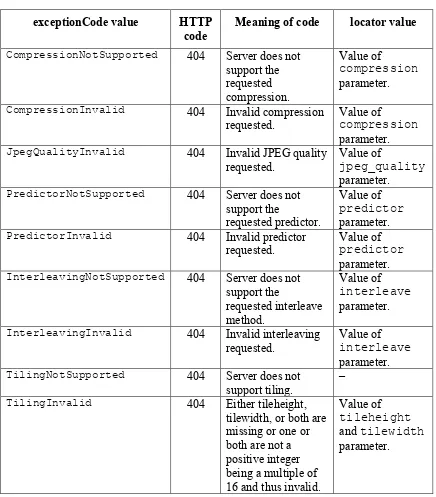
6.4.3 Exceptions
Requirement 18 /req/geotiff-coverage/exceptions:
When a server or service encounters an error described in column "meaning of exception code" in Table 3 then it shall return the corresponding exception report message with the contents of the locator parameter value as specified in the right column of Table 3.
Table 3 – Exception codes for GeoTIFF paremeters
exceptionCode value HTTP code
Meaning of code locator value
CompressionNotSupported 404 Server does not
support the
CompressionInvalid 404 Invalid compression requested.
Value of
compression
parameter.
JpegQualityInvalid 404 Invalid JPEG quality
requested.
Value of
jpeg_quality
parameter.
PredictorNotSupported 404 Server does not
support the
requested predictor.
Value of
predictor
parameter.
PredictorInvalid 404 Invalid predictor
requested.
Value of
predictor
parameter.
InterleavingNotSupported 404 Server does not support the
InterleavingInvalid 404 Invalid interleaving
requested.
Value of
interleave
parameter.
TilingNotSupported 404 Server does not
support tiling.
–
TilingInvalid 404 Either tileheight,
tilewidth, or both are missing or one or both are not a positive integer being a multiple of 16 and thus invalid.
Value of
tileheight
and tilewidth
Annex A (normative)
Abstract Test Suite
This Annex specifies an Abstract Test Suite which shall be passed in completeness by any implementation claiming conformance with this GeoTIFF coverage encoding profile.
Test identifiers below are relative to
http://www.opengis.net/spec/GMLCOV_geotiff-coverages/1.0/. A.1 Conformance Test Class: geotiff-coverage
The OGC URI identifier of this conformance class is:
http://www.opengis.net/spec/GMLCOV_geotiff-coverages/1.0/conf/geotiff-coverage. A.1.1 Prerequisites
Make sure that at least one GeoTIFF encoded coverage instance is available. Repeat the tests for each GeoTIFF encoded coverage instance available.
A.1.2 Follow TIFF specification
Test id: /conf/geotiff-coverage/tiff-specification
Test Purpose: Requirement /req/geotiff-coverage/tiff-specification: A GeoTIFF encoded coverage instance shall follow the TIFF specification [TIFF].
Test method: Validate the coverage instance under test against the TIFF specification.
Test passes if coverage instance is valid according to the TIFF specification.
A.1.3 Correct coverage type
Test id: /conf/geotiff-coverage/type
Test Purpose: Requirement /req/geotiff-coverage/type:
A GeoTIFF encoded coverage instance shall be of type
gmlcov:GridCoverage,gmlcov:RectifiedGridCoverage, or
gmlcov:ReferenceableGridCoverage, or a subtype thereof. Dependency: http://www.opengis.net/spec/GMLCOV/1.0/conf/gml-coverage
Test method: If the coverage instance under test is encoded in a multipart message check that its first part consists of a GML document of type
20 Copyright © 2014 Open Geospatial Consortium. gmlcov:ReferenceableGridCoverage, or a subtype thereof.
Test passes if constraint evaluates to true.
A.1.4 Follow GeoTIFF specification
Test id: /conf/geotiff-coverage/geotiff-specification
Test Purpose: Requirement /req/geotiff-coverage/geotiff-specification: A GeoTIFF encoded coverage instance and being of type
gmlcov:RectifiedGridCoverage, or
gmlcov:ReferenceableGridCoverage, or a subtype thereof shall follow the GeoTIFF specification [GeoTIFF] and shall contain the geo-referencing information of the coverage.
Test method: If the coverage instance under test is encoded in a multipart message and if its first part consists of a GML document of type
gmlcov:RectifiedGridCoverage,
gmlcov:ReferenceableGridCoverage, or a subtype thereof validate the coverage instance under test against the GeoTIFF specification.
Test passes if coverage instance is of one of the listed types and is valid according to the GeoTIFF specification.
A.1.5 Correct URI
Test id: /conf/geotiff-coverage/uri
Test Purpose: Requirement /req/geotiff-coverage/uri:
If the usage of URIs is possible GeoTIFF encoding of a coverage shall be indicated by the following URI:
http://www.opengis.net/spec/GMLCOV_geotiff-coverages/1.0/conf/geotiff-coverage
Test method: If the coverage instance under test is encoded in a multipart message check that the xlink:role attribute of the gml:rangeParameters
element of the gml:File element of the gml:rangeSet element of its first part has the value
" http://www.opengis.net/spec/GMLCOV_geotiff-coverages/1.0/conf/geotiff-coverage".
A.1.6 Correct MIME type
Test id: /conf/geotiff-coverage/mime-type-identifier
Test Purpose: Requirement /req/geotiff-coverage/mime-type-identifier:
GeoTIFF encoding of a coverage shall be indicated by the following MIME type identifier:
image/tiff
Test method: If the coverage instance under test is encoded in a multipart message check that the gml:mimeType element of the gml:File element of the
gml:rangeSet element of its first part as well as the Content-Type
header of its second part have the value "image/tiff".
Test passes if constraints evaluate to true.
A.1.7 Correct dimensions
Test id: /conf/geotiff-coverage/dimensions
Test Purpose: Requirement /req/geotiff-coverage/dimensions:
The domain of a GeoTIFF encoded coverage instance shall have exactly 2 dimensions.
Test method: If the coverage instance under test is encoded in a multipart message check that the dimension parameter of the gml:RectifiedGrid
element or of a subtype thereof or of a subtype of
gml:AbstractReferencealbeGrid of the gml:domainSet
element of its first part has the value "2".
Test passes if constraint evaluates to true.
A.1.8 Correct CRS
Test id: /conf/geotiff-coverage/crs
Test Purpose: Requirement /req/geotiff-coverage/crs:
The coordinate reference system identified by the value of the srsName
attribute of the gml:Envelope element of the gml:boundedBy
element of a GeoTIFF encoded coverage instance shall be the same as the coordinate reference system used in the GeoTIFF part.
Test method: If the coverage instance under test is encoded in a multipart message check that the srsName attribute of the gml:Envelope element of the
gml:boundedBy element its first part defines the same coordinate reference system as the one used in the second part which in case of
22 Copyright © 2014 Open Geospatial Consortium.
not present.
Test passes if constraint evaluates to true.
A.1.9 Correct axis ordering
Test id: /conf/geotiff-coverage/axis-ordering
Test Purpose: Requirement /req/geotiff-coverage/axis-ordering:
The value ordering of a GeoTIFF encoded coverage instance shall adhere to the axis order of the coordinate reference system identified by the value of the srsName attribute of the gml:Envelope element of the gml:boundedBy element.
Test method: If the coverage instance under test is encoded in a multipart message check that the coordinate reference system defined by the srsName
attribute of the gml:Envelope element of the gml:boundedBy
element of its first part defines the same axis ordering as the one used in the second part.
Test passes if constraint evaluates to true.
A.1.10 Correct raster space
Test id: /conf/geotiff-coverage/pixel-is-area
Test Purpose: Requirement /req/geotiff-coverage/pixel-is-area:
The domain of a GeoTIFF encoded coverage instance shall respect the coverage’s raster space as defined in the GeoTIFF specification
[GeoTIFF] i.e. PixelIsArea or PixelIsPoint.
Test method: If the coverage instance under test is encoded in a multipart message check that the values used in the gml:lowerCorner and
gml:upperCorner elements of gml:Envelope element of the
gml:boundedBy element of its first part are respecting the raster space setting used in the second part.
In case of PixelIsArea, type gmlcov:RectifiedGridCoverage,
and grid axis parallel to the CRS axis the difference between the values used in the gml:lowerCorner and gml:Envelope elements shall be the same as the number of pixels defined in the gml:domainSet
element multiplied with the respective value of the respective
gml:offsetVector element taking into account the right axis ordering.
In case of PixelIsPoint, type
CRS axis the difference between the values used in the
gml:lowerCorner and gml:Envelope elements shall be the same as the number of pixels defined in the gml:domainSet element minus 1 multiplied with the respective value of the respective
gml:offsetVector element taking into account the right axis ordering.
Test passes if constraints evaluate to true.
A.1.11 Correct range order
Test id: /conf/geotiff-coverage/range-ordering
Test Purpose: Requirement /req/geotiff-coverage/range-ordering:
A GeoTIFF encoded coverage instance with more than one component in the rangeType shall order the components of the coverage’s
rangeType in the same order as given in the gml:rangeType element’s document order.
Test method: If the coverage instance under test is encoded in a multipart message check that the ordering used in the gmlcov:rangeType element of its first part is the same as used in the second part.
Test passes if constraint evaluates to true.
A.1.12 Parameters XML
Test id: /conf/geotiff-coverage/parameters-xml
Test Purpose: Requirement /req/geotiff-coverage/parameters-xml:
The structure of an XML request requesting a GeoTIFF encoded coverage instance shall be extended as defined in Table 2 and the respective XML Schema being part of this standard.
Test method: Validate the GeoTIFF parameters present in the request if an XML request was used to obtain the coverage instance under test.
Test passes if an XML request was used to obtain the coverage instance under test and the GeoTIFF parameters are valid according to the XML schema and the coverage instance is encoded as requested.
A.1.13 Parameters KVP
Test id: /conf/geotiff-coverage/parameters-kvp
Test Purpose: Requirement /req/geotiff-coverage/parameters-kvp:
24 Copyright © 2014 Open Geospatial Consortium.
names shall be prefixed with "geotiff:" for example
geotiff:compression.
Test method: Validate the GeoTIFF parameters present in the request if a KVP request was used to obtain the coverage instance under test.
Test passes if a KVP request was used to obtain the coverage instance under test and the GeoTIFF parameters are valid according to Table 2 and the coverage instance is encoded as requested.
A.1.14 Parameter for compression
Test id: /conf/geotiff-coverage/compression
Test Purpose: Requirement /req/geotiff-coverage/compression:
The response to a successful request for a GeoTIFF encoded coverage containing a compression GeoTIFF parameter shall consist of a GeoTIFF encoded coverage using the specified compression whereas the following mapping applies:
Test method: Check the GeoTIFF parameters present in the request used to obtain the coverage instance under test for the presence of the "compression" parameter. If found, verify that the coverage instance is encoded using the requested compression.
Test passes if the "compression" parameter is present and the coverage instance is encoded as requested.
A.1.15 Parameter for JPEG compression
Test id: /conf/geotiff-coverage/jpeg
Test Purpose: Requirement /req/geotiff-coverage/jpeg:
The response to a successful request for a GeoTIFF encoded coverage containing a jpeg_quality and a compression parameter with value "JPEG" shall consist of a GeoTIFF encoded coverage using JPEG compression with the quality indicated.
Test method: Check the GeoTIFF parameters present in the request used to obtain the coverage instance under test for the presence of the "compression" and "jpeg_quality" parameters. If found, verify that the
"compression" parameter has value "JPEG" and the coverage instance is encoded using JPEG compression with the requested quality.
A.1.16 Parameter for predictor
Test id: /conf/geotiff-coverage/predictor
Test Purpose: Requirement /req/geotiff-coverage/predictor:
The response to a successful request for a GeoTIFF encoded coverage containing a predictor parameter shall consist of a GeoTIFF encoded coverage using the specified predictor
Test method: Check the GeoTIFF parameters present in the request used to obtain the coverage instance under test for the presence of the "predictor" parameter. If found, verify that the coverage instance is encoded using the requested predictor.
Test passes if the "predictor" parameter is present and the coverage instance is encoded as requested.
A.1.17 Parameter for interleave
Test id: /conf/geotiff-coverage/interleave
Test Purpose: Requirement /req/geotiff-coverage/interleave:
The response to a successful request for a GeoTIFF encoded coverage containing a interleave parameter shall consist of a GeoTIFF encoded coverage using the specified interleave method.
Test method: Check the GeoTIFF parameters present in the request used to obtain the coverage instance under test for the presence of the "interleave" parameter. If found, verify that the coverage instance is encoded using the requested interleave method.
Test passes if the "interleave" parameter is present and the coverage instance is encoded as requested.
A.1.18 Parameter for tiling
Test id: /conf/geotiff-coverage/tiling
Test Purpose: Requirement /req/geotiff-coverage/tiling:
The response to a successful request for a GeoTIFF encoded coverage containing a tiling and optionally a tileheight and a
tilewidth parameter shall consist of a GeoTIFF encoded coverage with internal tiling using the specified height and width if present.
Test method: Check the GeoTIFF parameters present in the request used to obtain the coverage instance under test for the presence of the "tiling"
26 Copyright © 2014 Open Geospatial Consortium.
coverage instance is encoded using the requested tiling.
Test passes if the "tiling" parameter and optionally the
"tileheight" and "tilewidth" parameters are present and the coverage instance is encoded as requested.
A.1.19 Exceptions
Test id: /conf/geotiff-coverage/exceptions
Test Purpose: Requirement /req/geotiff-coverage/exceptions:
When a server or service encounters an error described in column "meaning of exception code" in Table 3 then it shall return the
corresponding exception report message with the contents of the locator parameter value as specified in the right column of Table 3.
Test method: Validate possible exception responses obtained instead of coverage instances.
Test passes if exceptions are using the relevant exceptionCode.
Annex B (informative) Resources
B.1 Links
GeoTIFF at the Open Source Geospatial Foundation: http://geotiff.osgeo.org/
GeoTIFF mailing list: http://lists.maptools.org/mailman/listinfo/geotiff
GDAL – Geospatial Data Abstraction Library: http://www.gdal.org/
listgeo – Dump GeoTIFF Metadata: http://www.remotesensing.org/geotiff/listgeo.html
LibTIFF – TIFF Library and Utilities: http://www.remotesensing.org/libtiff/
B.2 Examples
This clause holds a valid example of a multipart GeoTIFF encoded coverage but omitting the GeoTIFF content itself as well as a WCS GetCoverage request including GeoTIFF parameters. Additionally the TIFF and GeoTIFF keys of the coverage are provided. These keys can easily be mapped to the GML part. The complete examples including the GeoTIFF content are available online at the same place as the accompanying XML schemas.
The following sketches a valid multipart coverage (contents of second part omitted):
Content-Type: Multipart/Related; boundary=wcs; start="GML-Part"
type="application/gml+xml"
--wcs
Content-Type: text/xml
<?xml version="1.0" encoding="UTF-8"?> <gmlcov:RectifiedGridCoverage
xmlns:xsi=http://www.w3.org/2001/XMLSchema-instance
xmlns:xlink=http://www.w3.org/1999/xlink
xmlns:gml=http://www.opengis.net/gml/3.2
xmlns:gmlcov=http://www.opengis.net/gmlcov/1.0
xmlns:swe=http://www.opengis.net/swe/2.0
xsi:schemaLocation=http://www.opengis.net/gmlcov/1.0 http://schemas.opengis.net/gmlcov/1.0/gmlcovAll.xsd
gml:id="grey">
<gml:boundedBy>
<gml:Envelope srsName="http://www.opengis.net/def/crs/EPSG/0/3857"
axisLabels="x y" uomLabels="m m" srsDimension="2">
<gml:lowerCorner>100 50</gml:lowerCorner>
<gml:upperCorner>500 350</gml:upperCorner>
</gml:Envelope>
</gml:boundedBy>
<gml:domainSet>
<gml:RectifiedGrid dimension="2" gml:id="grid_grey">
28 Copyright © 2014 Open Geospatial Consortium.
<gml:axisLabels>x y</gml:axisLabels>
<gml:origin>
<gml:offsetVector srsName="http://www.opengis.net/def/crs/EPSG/0/
3857">10 0</gml:offsetVector>
<gml:offsetVector srsName="http://www.opengis.net/def/crs/EPSG/0/
3857">0 -10</gml:offsetVector>
</gml:RectifiedGrid>
</gml:domainSet>
<gml:rangeSet>
<gml:File>
<gml:rangeParameters xlink:href="cid:grey.tif"
xlink:role=
"http://www.opengis.net/spec/GMLCOV_geotiff-coverages/1.0/conf/geotiff-coverage" xlink:arcrole="fileReference"/>
<gml:fileReference>cid:grey.tif</gml:fileReference>
<gml:fileStructure/>
<gml:mimeType>image/tiff</gml:mimeType>
Below the complete GeoTIFF information obtained via the listgeo command is shown:
Geotiff_Information: Version: 1
Key_Revision: 1.0 Tagged_Information:
ModelTiepointTag (2,3):
Keyed_Information:
GTModelTypeGeoKey (Short,1): ModelTypeProjected GTRasterTypeGeoKey (Short,1): RasterPixelIsArea
GTCitationGeoKey (Ascii,25): "WGS 84 / Pseudo-Mercator" GeogCitationGeoKey (Ascii,7): "WGS 84"
GeogAngularUnitsGeoKey (Short,1): Angular_Degree ProjectedCSTypeGeoKey (Short,1): Unknown-3857 ProjLinearUnitsGeoKey (Short,1): Linear_Meter End_Of_Keys.
End_Of_Geotiff.
PCS = 3857 (WGS 84 / Pseudo-Mercator)
Projection = 3856 (Popular Visualisation Pseudo-Mercator) Projection Method: CT_Mercator
ProjNatOriginLatGeoKey: 0.000000 ( 0d 0' 0.00"N) ProjNatOriginLongGeoKey: 0.000000 ( 0d 0' 0.00"E) ProjScaleAtNatOriginGeoKey: 1.000000
ProjFalseEastingGeoKey: 0.000000 m ProjFalseNorthingGeoKey: 0.000000 m GCS: 4326/WGS 84
Datum: 6326/World Geodetic System 1984
Ellipsoid: 7030/WGS 84 (6378137.00,6356752.31)
Prime Meridian: 8901/Greenwich (0.000000/ 0d 0' 0.00"E) Projection Linear Units: 9001/metre (1.000000m)
Corner Coordinates:
The following shows the output of the gdalinfo command:
Driver: GTiff/GeoTIFF Files: example_3857.tif Size is 40, 30
Coordinate System is:
PROJCS["WGS 84 / Pseudo-Mercator", GEOGCS["WGS 84",
DATUM["WGS_1984",
30 Copyright © 2014 Open Geospatial Consortium. AUTHORITY["EPSG","6326"]],
PRIMEM["Greenwich",0],
UNIT["degree",0.0174532925199433], AUTHORITY["EPSG","4326"]],
PROJECTION["Mercator_1SP"], PARAMETER["central_meridian",0], PARAMETER["scale_factor",1], PARAMETER["false_easting",0], PARAMETER["false_northing",0], AUTHORITY["EPSG","3857"],
EXTENSION["PROJ4","+proj=merc +a=6378137 +b=6378137 +lat_ts=0.0 +lon_0=0.0 +x_0=0.0 +y_0=0 +k=1.0 +units=m +nadgrids=@null +wktext +no_defs"],
UNIT["metre",1,
AUTHORITY["EPSG","9001"]]]
Origin = (100.000000000000000,350.000000000000000) Pixel Size = (10.000000000000000,-10.000000000000000) Metadata: Band 1 Block=40x30 Type=Byte, ColorInterp=Gray
The tiffinfo command outputs the following:
TIFFReadDirectory: Warning, example_3857.tif: unknown field with tag 33550 (0x830e) encountered.
TIFFReadDirectory: Warning, example_3857.tif: unknown field with tag 33922 (0x8482) encountered.
TIFFReadDirectory: Warning, example_3857.tif: unknown field with tag 34735 (0x87af) encountered.
TIFFReadDirectory: Warning, example_3857.tif: unknown field with tag 34737 (0x87b1) encountered.
TIFF Directory at offset 0x8 (8) Image Width: 40 Image Length: 30 Bits/Sample: 8
Sample Format: unsigned integer Compression Scheme: None
Photometric Interpretation: min-is-black Samples/Pixel: 1
Rows/Strip: 30
Planar Configuration: single image plane Tag 33550: 10.000000,10.000000,0.000000
Tag 33922: 0.000000,0.000000,0.000000,100.000000,350.000000,0.000000 Tag 34735:
1,1,0,7,1024,0,1,1,1025,0,1,1,1026,34737,25,0,2049,34737,7,25,2054,0,1,9 102,3072,0,1,3857,3076,0,1,9001
Finally the tiffdump command gives:
example_3857.tif:
Magic: 0x4949 <little-endian> Version: 0x2a Directory 0: offset 8 (0x8) next 0 (0) ImageWidth (256) SHORT (3) 1<40>
ImageLength (257) SHORT (3) 1<30> BitsPerSample (258) SHORT (3) 1<8> Compression (259) SHORT (3) 1<1> Photometric (262) SHORT (3) 1<1> StripOffsets (273) LONG (4) 1<363> SamplesPerPixel (277) SHORT (3) 1<1> RowsPerStrip (278) SHORT (3) 1<30> StripByteCounts (279) LONG (4) 1<1200> PlanarConfig (284) SHORT (3) 1<1> SampleFormat (339) SHORT (3) 1<1> 33550 (0x830e) DOUBLE (12) 3<10 10 0>
33922 (0x8482) DOUBLE (12) 6<0 0 0 100 350 0>
34735 (0x87af) SHORT (3) 32<1 1 0 7 1024 0 1 1 1025 0 1 1 1026 34737 25 0 2049 34737 7 25 2054 0 1 9102 ...>
34737 (0x87b1) ASCII (2) 33<WGS 84 / Pseudo-Mercator ...>
The following is a valid WCS 2.0 GetCoverage request including some GeoTIFF parameters:
<?xml version="1.0" encoding="UTF-8"?> <wcs:GetCoverage
xmlns:wcs="http://www.opengis.net/wcs/2.0"
xmlns:geotiff="http://www.opengis.net/gmlcov/geotiff/1.0" xmlns:gml="http://www.opengis.net/gml/3.2"
xmlns:xsi="http://www.w3.org/2001/XMLSchema-instance" xsi:schemaLocation="http://www.opengis.net/wcs/2.0 http://schemas.opengis.net/wcs/2.0/wcsAll.xsd
<geotiff:parameters>
<geotiff:compression>JPEG</geotiff:compression>
<geotiff:jpeg_quality>75</geotiff:jpeg_quality>
<geotiff:predictor>None</geotiff:predictor>
<geotiff:interleave>pixel</geotiff:interleave>
<geotiff:tiling>true</geotiff:tiling>
<geotiff:tileheight>256</geotiff:tileheight>
<geotiff:tilewidth>256</geotiff:tilewidth>
</geotiff:parameters>
</wcs:Extension>
<wcs:CoverageId>grey</wcs:CoverageId>
<wcs:format>image/tiff</wcs:format>
32 Copyright © 2014 Open Geospatial Consortium.
Annex C Bibliography
OGC 09-110r4, OGC® Web Coverage Service 2.0 Interface Standard – Core, version 2.0
Annex D: Revision history
Date Release Editor Primary clauses modified
Description
2012-08-08 0.0.1 Stephan Meissl All First draft based on discussions in the WCS.SWG.
2012-08-13 0.0.2 Stephan Meissl, Peter Baumann
All Minor corrections and format adaptions. 2012-08-22 0.0.3 Stephan Meissl Clauses 6.3.1 and
B.2
Added additional notes and examples as discussed in WCS.SWG teleconference. 2012-09-12 0.0.4 Stephan Meissl All, Clauses 2
and 3
Adjusted URIs, integrated comments received, and added ATS.
2012-10-24 0.0.5 Stephan Meissl Clause 3 and Annex C
Moved normative references from bibliography to clause 3.
2013-06-26 0.0.6 Stephan Meissl Clause 6.3.1 All All
Adjusted Requirement 9 and associated note.