TRANSFER OF TECHNOLOGY FOR CADASTRAL MAPPING IN TAJIKISTAN USING
HIGH RESOLUTION SATELLITE DATA
Romuald Kaczynski
FINNMAP FM-International, Malminakaari 5, Helsinki, Finland – [email protected] and
Dept. of Remote Sensing and Photogrametry, Civil Engineering and Geodesy Faculty, Military University of Technology 2, Gen. Kaliskiego Street, 00-907 Warsaw, Poland – [email protected]
COMISSION VI//4: Cross-Border Education 2: Joint Educational Programs
KEY WORDS: Agriculture, Developing Countries, Education, Photogrammetry, Orthoimage, Digital mapping, Technology transfer
ABSTRACT:
European Commission funded project entitled: “Support to the mapping and certification capacitв of the Agencв of Land Management, Geodesв and Cartographв” in Tajikistan was run by FINNMAP FM-International and Human Dynamics from Nov. 2006 to June 2011. The Agency of Land Management, Geodesy and Cartography is the state agency responsible for development, implementation, monitoring and evaluation of state policies on land tenure and land management, including the on-going land reform and registration of land use rights. The specific objective was to support and strengthen the professional capacity of the “Faгo” Institute in the field of satellite geodesв, digital photogrammetry, advanced digital satellite image processing of high resolution satellite data and digital cartography. Lectures and on-the-job trainings for the personnel of “Faгo” and Agencв in satellite geodesy, digital photogrammetry, cartography and the use of high resolution satellite data for cadastral mapping have been organized. Standards and Quality control system for all data and products have been elaborated and implemented in the production line. Technical expertise and trainings in geodesy, photogrammetrв and satellite image processing to the World Bank project “Land Registration and Cadastre Sвstem for Sustainable Agriculture” has also been completed in Tajikistan. The new map projection was chosen and the new unclassified geodetic network has been established for all of the country in which all agricultural parcel boundaries are being mapped. IKONOS, QuickBird and WorldView1 panchromatic data have been used for orthophoto generation. Average accuracy of space triangulation of non-standard (long up to 90km) satellite images of QuickBird Pan and IKONOS Pan on ICPs: RMSEx=0.5m and RMSEy=0.5m have been achieved. Accuracy of digital orthophoto map is RMSExy=1.0m. More then two and half thousands of digital orthophoto map sheets in the scale of 1:5000 with pixel siгe 0.5m have been produced so far bв the “Faгo” Institute in Tajikistan on the basis of technologв elaborated in the framework of this project. Digital cadastral maps are produced in “Faгo” and Cadastral Regional Centers in Tajikistan using ArcMap software. These digital orthophotomaps will also be used for digital mapping of water resources and other needs of the country.
1. INTRODUCTION
The main objective of the project was to support the implementation of transparent and efficient land reform process in Tajikistan through capacity building and assisting the Agency of Land Management, Geodesy and Cartography (ALMGC) in preparation of geodetic and modern photogrammetric data for cadastral mapping of agricultural land. The modern cadastral system based on a parcel map with right dimensions, right shape in open geodetic coordinates system, and correctly computed areas of parcels, cannot be done nowadays without the use of modern mapping technology and the new high resolution satellite data: QuickBird, WorldView1,2, IKONOS, GeoEye1. Moreover, it was not possible to acquire aerial photographs in the highly mountainous Tajikistan. Also, no specialists in modern mapping technology were available in the country. Therefore, strengthening of the professional capacity of the “Faгo” Institute was necessary in the field of satellite geodesy, digital photogrammetry, advanced digital satellite image processing and advanced digital cartography. As two other projects were running at that time in Tajikistan - cooperation and providing expertise for World Bank (WB) project: “Land Registration and Cadastre Sвstem for Sustainable Agriculture” and SIDA project: “Capacity Building for Implementation of the Law of Registration of Land and Immovable Property and Rights to it” has been established.
2. MAIN ACTIVITIES
• Lectures and on-the-job training in field of satellite geodesy, modern digital photogrammetry methods, digital satellite image processing and digital cartography;
• Training in the use of new High Resolution Satellite Data (HRSD) for cadastral mapping of the agricultural land;
• Assisting Institute “Faгo” in the establishment of the new unclassified geodetic network;
• Development and implementation of the technologies for digital mapping in the scale of 1:5000 with the use of IKONOS, QuickBird and WorldView1 with DEM from Shuttle Radar Topographic Mission (SRTM); • Preparation of technical manuals, instructions and
Standard Operational Procedures (SOP) for all steps; • Providing technical expertise for the identification,
measurement of GCP’s and ICP’s and subsequent use of these data for orthorectification of HRSD;
• Assisting Institute “Faгo” in the calibration, orientation, georeferencing and orthorectification of raw HRSD and the use of raw SRTM data;
• Transferring know-how in all above fields to the staff of the Institute “Faгo”;
International Archives of the Photogrammetry, Remote Sensing and Spatial Information Sciences, Volume XXXIX-B6, 2012 XXII ISPRS Congress, 25 August – 01 September 2012, Melbourne, Australia
• Elaboration and implementation of a Quality Control
• Organizing of study tours to private and governmental cartographic institutions in Europe (Germany, Finland, Poland), Russia, Kazakhstan, Uzbekistan, Turkey and the Republic of China;
• Providing English lessons for the technical personnel of “Faгo” Institute.
New geodetic network for the agricultural areas
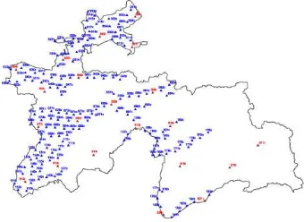
New geodetic network ITRF2005 and UTM in 6° zones have been chosen as the coordinate system for digital cadastral mapping of agricultural areas. The 1st class network covers all of the territory of Tajikistan with 21 stations spaced at 100 km and 2nd class network 185 stations with 20 km spacing.Based on simultaneous readjustment of the 1st and 2nd order networks, a catalog of the geodetic networks for cadastre mapping has been compiled and is now used also for other needs.
Figure 1. New open and unclassified 1st class (red color) and 2nd class (blue) GPS network established under supervision of Dr. V. Kotzev, project expert in Geodesy.
Figure 2. Geodetic point
Training courses in GPS technology and conventional surveying have been organized for the personnel of “Faгo” and the other institutes within ALMGC. Standards and specifications for establishment of cadastral GPS networks and standard operation procedures (SOP) for determining coordinates of ground control points (GCPs), ICPs and Quality
Control System for geodetic data have been developed and implemented in “Faгo” Institute. The WB project has been provided with technical expertise for establishment of a continuously operating GPS network, use and maintenance of their geodetic equipment, acquiring high resolution satellite images, and with trainings in GPS and geodesy for the staff of the Regional Land Cadastre Centers.
Photogrammetry and Cartography
The lectures and trainings in the methods of digital photogrammetry and advanced satellite image processing have been accomplished for 6 specialists from Photrogrammetry Department in “Faгo” Institute. Lectures and on-the-job training in the use of the DDPS, ERDAS Imagine, LPS ERDAS, 3dem and MicroDEM software have been given as well. Many handouts, Standard Operational Procedures for elaborating digital orthoiamges with the use of Very High Resolution Data and Landsat ETM have been implemented in the production line. Elaborated methodology for correction and georeferencing of scanned old paper maps to the new UTM coordinate system are now being used in “Faгo” for the production of the new digital maps in large scale 1:2000, using digital ortho images elaborated from WorldView1
.
Lectures on the methodology of cadastral mapping, updating cadastral data with the GPS measurements and work with digital cadastral data have been organiгed for 9 “Faгo” specialists. SOP for updating digital cadastral data with GPS measurements using the ArcGIS software (ArcCatalog and ArcMap modules) were elaborated in English and Russian. ArcGIS modules ArcCatalog and ArcMap were used for digital cadastral map elaboration on the basis’s of digital orto images. Average accuracy of space triangulation of non regular and long size satellite images of IKONOS Pan on GCPs was:
SRTM form Shuttle Radar Topography Mission has produced DSM (Digital Surface Model) with spacing 3 arc sec, corresponding approx. to the GRID 90m in the Earth surface. Vertical accuracy of DEM should be no worse than 10m LE90 for precision digital orthophoto images (Jacobsen, K. 2006). Manual editing process of DEM has been done prior to mosaicking geometrically into suitable blocks, balanced to ensure consistent levels of brightness, contrast and saturation and then cut into map size sheet 2.5 x 2.5 km tiles for the 0.50 meter output pixel and also printed as hard copy in the scale of 1:5000. Accuracy of digital orthophoto images: CE90=2.3m for QuickBird, CE90=2.0m for IKONOS and CE90=1.7m for WorldView1 have been achieved.
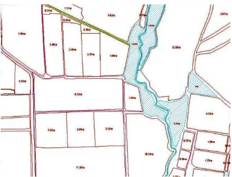
An example of orthoimage is shown in Fig.3 and cadastral digital map in Fig 4.
International Archives of the Photogrammetry, Remote Sensing and Spatial Information Sciences, Volume XXXIX-B6, 2012 XXII ISPRS Congress, 25 August – 01 September 2012, Melbourne, Australia
Figure 3. Sample of digital ortho of agricultural area
Figure 4. Sample of cadastral map elaborated in ArcMap
3. CONCLUSIONS AND RCOMMENDATIONS
The staff of “Faгo” Institute is now able to produce themselves all geodetic, photogrammetric and cartographic jobs for cadastral mapping of agricultural areas using high resolution satellite data and GPS techniques.
The “Faгo” Institute was granted the first prize for the best industry innovative project using Earth remote sensing data at the International Conference in Moscow in April 2010 for the project: “Technology for Digital Cadastral Mapping in Tajikistan with the use of HRSD”.
It is recommended to establish the Remote Sensing Center in “Faгo” Institute in Dushanbe and transform to the local staff the modern Remote Sensing technology and methods for digital elaboration of new generation of multispectral, multi-temporal satellite images, classification methods, analysis, change detection in agricultural areas, information extraction, modeling, statistics, elaboration of different maps for agriculture, environment protection and water resources sectors. Remote Sensing Center will be able to supply the different decision makers with objective information obtained from processing and interpretation of different satellite images.
4. REFERENCES
Jacobsen, K., 2006. SRTM Height Models. GEOconnexion International Magazine.
Kaczynski, R., Kotzev, V., 2011. Project Completion Report. EUROPEAID 122738/C/SER/TJ, Dushanbe.
Kaczynski, R., 2009. Cadastral mapping in Tajikistan. GIM International, Issue 10, Vol. 23: 67- 69.
Kaczynski, R., Marahina, S., 2010. Т я
а а а а а я Та а
а а
а ш я. GEOMATICS, Moscow, No 3 (8): 86-90.
International Archives of the Photogrammetry, Remote Sensing and Spatial Information Sciences, Volume XXXIX-B6, 2012 XXII ISPRS Congress, 25 August – 01 September 2012, Melbourne, Australia