* Red color warning does not mean "Red Alert" Red color warning means "Take Action".
Forecast and Warning for any day is valid from 0830 hours IST of day till 0830 hours IST of next day For more details kindly visit www.imd.gov.in or contact : +91 11 24631913, 24643965, 24629798
Friday 04 September 2020 MORNING Time of Issue: 0800 hours IST ALL INDIA WEATHER SUMMARY AND FORECAST BULLETIN
Significant Weather Features
Main Weather Observations
♦ Rain/Thundershowers observed (from 0830 hrs IST to 1730 hrs IST of yesterday): at most places over Himachal Pradesh and East Rajasthan; at many places over Punjab, West Rajasthan and South Interior Karnataka; at a few places over Andaman & Nicobar Islands and Sub-Himalayan West Bengal & Sikkim; at isolated places over Jammu & Kashmir, Ladakh, Gilgit-Baltistan & Muzaffarabad, Haryana, Chandigarh & Delhi, Madhya Pradesh, Uttar Pradesh, Saurashtra & Kutch, Madhya Maharshtra, Chhattisgarh, Odisha, Coastal Andhra Pradesh & Yanam, North Interior Karnataka, Gangetic West Bengal, Assam & Meghalaya, Kerala & Mahe and Tamilnadu, Puducherry & Karaikal.
♦ Rainfall recorded (from 0830 hrs IST to 1730 hrs IST of yesterday) (2 cm or more): Kota-9; Bagdogra-6; Udaipur-5; Nahan-4;
Sundernagar, Bhilwara & Tirutani-3 each; Mandi, Jaipur, Ajmer, Ujjain, Mahabaleshwar, Koraput, Hassan & Periakulum-2 each.
♦ Yesterday, heavy rainfall was observed at isolated places over East Rajasthan.
♦ Thunderstorm observed (from 1730 hours IST of yesterday to 0530 hrs IST of today): at isolated places over Assam & Meghalaya, Jammu & Kashmir, Ladakh, Gilgit-Baltistan & Muzaffarabad, Haryana, Punjab, Rajasthan, Bihar, East Madhya Pradesh, Vidarbha, Chhattisgarh, Madhya Maharshtra, Marathawada, Sub-Himalayan West Bengal & Sikkim, Karnataka, Tamilnadu, Puducherry & Karaikal, Rayalaseema, Kerala & Mahe and Coastal Andhra Pradesh & Yanam.
♦ Maximum Temperature Departures as on 03-09-2020: Maximum temperatures were appreciably above normal (3.1°C to 5.0°C) at many places over Vidarbha; at a few places over Madhya Maharashtra and Assam & Meghalaya; at isolated places over Madhya Pradesh, Telangana, Chhattisgarh and Nagaland, Manipur, Mizoram & Tripura; above normal (1.6°C to 3.0°C) at most palaces over West Bengal
& Sikkim, Marathwada and Odisha; at a few places over Bihar, Saurashtra & Kutch and Konkan & Goa; at isolated places over Uttarakhand, East Pradesh, Gujarat region, South Interior Karnataka and Kerala. They were appreciably below normal (-3.1°C to -5.0°C) at isolated places over East Rajasthan; below normal (-1.6°C to -3.0°C) at a few places over West Rajasthan and Tamilnadu, Puducherry
& Karaikal and near normal over rest parts of the country. Yesterday, the highest maximum temperature of 37.5°C was reported at Ganganagar (West Rajasthan).
♦ Minimum Temperature Departures as on 03-09-2020: Minimum temperatures were appreciable above normal (3.1°C to 5.0°C) at a few places over Uttarakhand, Haryana & Delhi and Madhya Maharashtra; at isolated places over Jammu & Kashmir, Ladakh, Gilgit- Baltistan & Muzaffarabad and Himachal Pradesh; above normal (1.6°C to 3.0°C) at most places over West Uttar Pradesh, Gujarat state, Sub-Himalayan West Bengal & Sikkim; at a few places over Rajasthan, Madhya Pradesh and Assam & Meghalaya and at isolated places over Punjab, Konkan & Goa, Marathawada, Vidharbha, Telangana, Bihar, Nagaland, Manipur, Mizoram & Tripura, South Interior Karnataka, and Andaman, Nicobar Islands. They were below normal (-1.6°C to -3.0°C) at isolated places over Tamilnadu, Puducherry &
Karaikal and near normal over rest parts of the country. Yesterday, the lowest minimum temperature of 20.4°C was reported at Chanderpur (Vidharbha) over the plains of the country.
♦ The western end of the Monsoon Trough at mean sea level lies south of its normal position and is likely to remain so during next 24 hours. The eastern end lies to the north of its normal position. The Monsoon trough is likely to shift north of its normal position from 05th September onwards.
♦ A cyclonic circulation lies over northwest Rajasthan & neighbourhood and another over northwest Madhya Pradesh & neighbourhood in the lower tropospheric levels. Under the influence of the above systems, isolated Heavy rainfall accompanied with thunderstorm &
lightning very likely over Himachal Pradesh, Rajasthan on 04th September and over Uttarakhand during 04th-07th September, 2020.
♦ A cyclonic circulation lies over eastcentral and adjoining southeast Arabian Sea off Karnataka & north Kerala coasts at lower & middle tropospheric levels. Under its influence, Fairly widespread to widespread rainfall with isolated heavy falls and thunderstorm & lightning very likely over Peninsular India during next 3-4 days.
♦ Moderate thunderstorms with lightening very likely over Rajasthan, Konkan & Goa and Kerala & Mahe during next 12 hours.
* Red color warning does not mean "Red Alert" Red color warning means "Take Action".
Forecast and Warning for any day is valid from 0830 hours IST of day till 0830 hours IST of next day For more details kindly visit www.imd.gov.in or contact : +91 11 24631913, 24643965, 24629798
Meteorological Analysis (Based on 0530 hours IST)
Weather Forecast for next 5 days * upto 0830 hours IST of 09th September, 2020
Weather Outlook for subsequent 2 days from 09th September, 2020 to 11th September, 2020.
♦ Meteorological sub-division wise detailed 5 days precipitation forecast is given in Table-1.
♦ No significant change in temperatures very likely over most parts of the country during next 3-4 days.
♦ The Monsoon Trough at mean sea level now passes through Bikaner, Jaipur, Gwalior, Satna, Daltonganj, Shantiniketan and thence eastwards to Manipur across Bangladesh & south Assam.
♦ The cyclonic circulation over northwest Rajasthan & neighbourhood extending upto 1.5 km above mean sea level persists.
♦ The trough in the mid & upper tropospheric westerlies with its axis at 5.8 km above mean sea level roughly along Long. 62°E to the north of Lat. 30°N persists.
♦ The cyclonic circulation over north Chhattisgarh & neighbourhood extending upto 0.9 km above mean sea level persists.
♦ The cyclonic circulation over eastcentral and adjoining southeast Arabian Sea off Karnataka & north Kerala coasts extending upto 4.5 km above mean sea level tilting southwards with height persists.
♦ The cyclonic circulation over northwest Madhya Pradesh & neighbourhood extending upto 2.1km above mean sea level persists.
♦ The cyclonic circulation over south Chhattisgarh & neighbourhood between 3.1 and 4.5 km above mean sea level persists.
♦ Fairly widespread rainfall with isolated heavy falls likely over East & northeast India and south Peninsular India. Isolated to scattered rainfall over parts of Northwest & adjoining Central India. Dry weather likely over Gujarat state and West Rajasthan.
* Red color warning does not mean "Red Alert" Red color warning means "Take Action".
Forecast and Warning for any day is valid from 0830 hours IST of day till 0830 hours IST of next day For more details kindly visit www.imd.gov.in or contact : +91 11 24631913, 24643965, 24629798
Weather Warning during next 5 days *
04 September (Day 1): ♦ Heavy rainfall likely at isolated places over Arunachal Pradesh, Assam & Meghalaya, Sub-Himalayan West Bengal & Sikkim, Uttarakhand, Himachal Pradesh, Rajasthan, south Konkan & Goa, Madhya Maharashtra, Coastal & south interior Karnataka, Tamilnadu, Puducherry & Karaikal and Kerala & Mahe.
♦ Thunderstorm accompanied with lightning likely at isolated places over Arunachal Pradesh, Assam & Meghalaya, Nagaland, Manipur, Mizoram & Tripura, Sub-Himalayan West Bengal & Sikkim, Uttar Pradesh, Konkan & Goa, Madhya Maharashtra, Marathwada, Coastal Andhra Pradesh, Tamilnadu, Puducherry & Karaikal, Kerala & Mahe and Karnataka.
♦ Strong Wind (speed reaching 45-55 kmph) very likely over Southwest Arabian Sea and Squally weather with wind (speed reaching 40- 50 kmph) southeast, east central Arabian Sea, Lakshadweep area, south Maharashtra coasts. Fishermen are advised not to venture into these areas.
05 September (Day 2): ♦ Heavy rainfall likely at isolated places over Arunachal Pradesh, Assam & Meghalaya, Nagaland, Sub- Himalayan West Bengal & Sikkim, Uttarakhand, Madhya Maharashtra, Tamilnadu, Puducherry & Karaikal, Coastal & South Interior Karnataka, and Kerala & Mahe.
♦ Thunderstorm accompanied with lightning likely at isolated places over Arunachal Pradesh, Assam & Meghalaya, Nagaland, Manipur, Mizoram & Tripura, Odisha, West Bengal & Sikkim, Konkan & Goa, Madhya Maharashtra, Marathwada, Chhattisgarh, Tamilnadu, Puducherry & Karaikal, Kerala & Mahe.
♦ Strong Wind (speed reaching 45-55 kmph) very likely over Southwest Arabian Sea. Fishermen are advised not to venture into these areas.
06 September (Day 3): ♦ Heavy to very heavy rainfall likely at isolated places over Sub-Himalayan West Bengal & Sikkim and heavy rainfall at isolated places over Odisha, Jharkhand, Bihar, East Uttar Pradesh, Uttarakhand, Madhya Maharashtra, Coastal & Interior Karnataka, Tamilnadu, Puducherry & Karaikal and Kerala & Mahe.
♦ Thunderstorm accompanied with lightning likely at isolated places over Bihar, Jharkhand, Gangetic West Bengal, Konkan & Goa, Madhya Maharashtra, Marathwada, Chhattisgarh, Telangana and Tamilnadu, Puducherry & Karaikal.
♦ Strong Wind (speed reaching 45-55 kmph) very likely over Southwest Arabian Sea. Fishermen are advised not to venture into these areas.
07 September (Day 4): ♦ Heavy rainfall at isolated places over Assam & Meghalaya, Nagaland, Sub-Himalayan West Bengal &
Sikkim, Bihar, East Uttar Pradesh, Uttarakhand, Chhattisgarh, Coastal Andhra Pradesh & Yanam, Telangana, Rayalaseema, Tamilnadu, Puducherry & Karaikal, Karnataka and Kerala & Mahe.
♦ Thunderstorm accompanied with lightning likely at isolated places over Bihar, Jharkhand, Gangetic West Bengal, Konkan & Goa, Madhya Maharashtra, Chhattisgarh, Telangana and Tamilnadu, Puducherry & Karaikal.
♦ Strong Wind (speed reaching 45-55 kmph) very likely over Southwest Arabian Sea. Fishermen are advised not to venture into these areas and Squally weather with wind (speed reaching 40-50 kmph) over Comorin, Lakshadweep, Maldives areas and Gulf of Mannar.
Fishermen are advised not to venture into these areas.
08 September (Day 5): ♦ Heavy rainfall at isolated places over Assam & Meghalaya, Nagaland, Sub-Himalayan West Bengal &
Sikkim, Bihar, East Uttar Pradesh, Uttarakhand, Chhattisgarh, Coastal Andhra Pradesh & Yanam, Telangana, Rayalaseema, Tamilnadu, Puducherry & Karaikal, Karnataka and Kerala & Mahe.
♦ Thunderstorm accompanied with lightning likely at isolated places over Bihar, Jharkhand, Gangetic West Bengal, Konkan & Goa, Madhya Maharashtra, Chhattisgarh, Telangana and Tamilnadu, Puducherry & Karaikal.
♦ Strong Wind (speed reaching 45-55 kmph) very likely over Southwest Arabian Sea. Fishermen are advised not to venture into these areas and Squally weather with wind (speed reaching 40-50 kmph) over Comorin, Lakshadweep, Maldives areas and Gulf of Mannar.
Fishermen are advised not to venture into these areas.
Kindly download MAUSAM APP for location specific forecast & warning, MEGHDOOT APP for Agromet advisory and DAMINI APP for Lightning Warning & visit state MC/RMC website for district wise warning.
* Red color warning does not mean "Red Alert" Red color warning means "Take Action".
Forecast and Warning for any day is valid from 0830 hours IST of day till 0830 hours IST of next day For more details kindly visit www.imd.gov.in or contact : +91 11 24631913, 24643965, 24629798
Table-1
ALL INDIA WEEKLY WEATHER REPORT 27 AUGUST – 02 SEPTEMBER 2020
Table-1(A) Table-1(B) Table-1(C) Table-2 Table-3 Fig-1 Fig-2 Annexure-1
SIGNIFICANT WEATHER FEATURES
♦ A Well Marked Low Pressure Area lay over southwest Jharkhand & neighbourhood in the beginning of the week; maintaining the same intensity, it moved nearly west-northwestwards and lay over north Chhattisgarh & adjoining East Madhya Pradesh on 28th and over central parts of north Madhya Pradesh &
adjoining south Uttar Pradesh on 29th; it weakened into a Low pressure area in the early morning hours of 30th and it lay over West Madhya Pradesh and adjoining East Rajasthan; moving west-northwestwards further, it lay over West Rajasthan & neighbourhood on 31st August 2020 and over Pakistan & adjoining West Rajasthan on 1st September 2020 before merging with the heat low in the early morning hours of 2nd September; however, Its remnant cyclonic circulation in the lower levels lay over Punjab & adjoining Pakistan towards the end of the week. During its course of movement west-northwestwards, this system has caused fairly widespread to widespread rainfall/thunderstorms along with intense to very intense rainfall activity over parts of east, central and northwest India and over Gujarat State and northern parts of Maharashtra during the week.
♦ Strong easterlies in the lower levels due to the presence of the Low pressure area in the neighbourhood, a trough in mid level westerlies and cyclonic circulations in the lower levels have caused scattered to fairly widespread rain/thunderstorms over Western Himalayan Region and adjoining plains of Northwest India along with intense rainfall activity over these regions during the week.
♦ Positioning of the eastern end of the monsoon trough close to the foot hills of Himalayas and presence of cyclonic circulations in the lower levels have caused fairly widespread to widespread rainfall/thunderstorms along with intense to very intense rainfall activity over northeast India during the week.
♦ A north-south trough in the lower levels across eastern part of south peninsula has caused scattered to fairly widespread rainfall/thunderstorms along with intense to very intense rainfall activity over parts of South Peninsular India during the week.
♦ The southern end of the west coast and Lakshadweep had subdued rainfall activity during the first half of the week.
Heavy Rainfall Activity:
♦ Heavy to very heavy rainfall with extremely heavy rainfall at isolated places had been occurred over East and West Madhya Pradesh and Saurashtra & Kutch on two days each; over Chhattisgarh, East and West Rajasthan, Sub Himalayan West Bengal & Sikkim and Odisha on one day each during the week.
♦ Heavy to very heavy rainfall had been occurred at isolated places over Assam & Meghalaya on six days;
over Sub Himalayan West Bengal & Sikkim, Gujarat Region, Konkan & Goa, and Chhattisgarh on two days each; over Arunachal Pradesh, Odisha, Bihar, West Uttar Pradesh, Haryana, Chandigarh & Delhi, Punjab, Jammu & Kashmir, East Rajasthan, East & West Madhya Pradesh, Vidarbha, Coastal Andhra Pradesh &
Yanam, Tamil Nadu, Puducherry & Karaikkal, Telangana and Rayalaseema on one day each during the week.
♦ Heavy rainfall had been occurred at isolated places over Arunachal Pradesh, Madhya Maharashtra, Tamil Nadu , Puducherry & Karaikkal and South Interior Karnataka on four days each; over Jharkhand, Himachal Pradesh, West Rajasthan, Gujarat Region and Rayalaseema on three days each; over Nagaland, Manipur, Mizoram & Tripura, Gangetic West Bengal, Odisha, East & West Uttar Pradesh, Uttarakhand, Jammu &
Kashmir, East Rajasthan, Saurashtra & Kutch, Konkan & Goa, Vidarbha, Coastal Andhra Pradesh &
Yanam and Coastal Karnataka on two days each; over Andaman& Nicobar Islands, Sub Himalayan West Bengal & Sikkim, Punjab, East & West Madhya Pradesh, Chhattisgarh and Telangana on one day each during the week.
Temperature Scenario:
♦ The highest maximum temperature of 38.8 o C had been recorded at Thiruchirappalli (Tamil Nadu) on 29th August 2020 over the plains of the country during the week.
LEGEND: A few days- 3 days, Many days- 4 to 5 days and Most days- 6 to 7 days during the week.
Government of India Ministry of Earth Sciences India Meteorological Department National Weather Forecasting Centre
METEOROLOGICALANALYSIS
♦ Last week’s Well Marked Low Pressure Area lay over southwest Jharkhand & neighbourhood with the associated cyclonic circulation extending upto 7.6 km above mean level tilting southwestwards with height on 27th August 2020; it lay over north Chhattisgarh & adjoining East Madhya Pradesh with the associated cyclonic circulation extending upto 7.6 km above mean level tilting southwestwards with height on 28th; it lay over central parts of north Madhya Pradesh & adjoining south Uttar Pradesh with the associated cyclonic circulation extending upto 7.6 km above mean sea level tilting southwestwards with height on 29th; it has weakened into a Low pressure area in the early morning hours and lay over West Madhya Pradesh and adjoining East Rajasthan with the associated cyclonic circulation extending upto 7.6 km above mean sea level tilting southwestwards with height on 30th; it lay over West Rajasthan & neighbourhood with the associated cyclonic circulation extending upto 5.8 km above mean sea level tilting southwestwards with height on 31st August 2020; it lay over Pakistan &
adjoining West Rajasthan with the associated cyclonic circulation extending upto 3.1 km above mean sea level on 1st September 2020; the Low pressure area has merged with the heat low in the early morning of 2nd September however, its associated cyclonic circulation lay over Pakistan and adjoining Punjab extending upto 3.1 km above mean sea level; it lay over Punjab & adjoining Pakistan extending upto 3.1 km above mean sea level in the forenoon of 2nd September 2020.
♦ The western end of the Monsoon Trough at mean sea level ran close to the foothills of Himalayas whereas the eastern end passed through Bahraich, Varanasi, the centre of Well Marked Low Pressure Area over southwest Jharkhand & neighbourhood, Digha and thence southeastwards to North Bay of Bengal on 27th August 2020; it passed through Ganganagar, Narnaul, Shivpuri, centre of Well Marked Low Pressure Area over north Chhattisgarh & adjoining East Madhya Pradesh, Jamshedpur, Midnapore and thence southeastwards to North Bay of Bengal on 28th; it passed through Bikaner, Jaipur, centre of Well Marked Low Pressure Area over central parts of north Madhya Pradesh & adjoining south Uttar Pradesh, Ranchi, Krishnanagar and thence southeastwards to North Bay of Bengal on 29th; it passed through Jaisalmer, centre of Low Pressure Area over West Madhya Pradesh & adjoining East Rajasthan, Sidhi, Churk, Patna, Goalpara and thence eastwards to Nagaland on 30th; it passed through centre of Low Pressure Area over West Rajasthan & neighbourhood, Mathura, Bahraich and thence close to foothills of Himalayas on 31st August 2020; The western parts of the Monsoon Trough at mean sea level passed through centre of Low Pressure Area over Pakistan & adjoining West Rajasthan, Pilani and Badaun whereas the eastern end ran close to foothills of Himalayas on 1st September 2020; the western end of the Monsoon Trough at mean sea level continued to run close to the foothills of Himalayas whereas the eastern end passed through Bahraich, Gaya, Shantiniketan and thence eastwards to Manipur across Bangladesh & south Assam on 2nd September 2020.
♦ Last week’s cyclonic circulation over south Pakistan & neighbourhood lay over southeast Pakistan &
neighbourhood and extended between 3.1 & 5.8 km above mean sea level tilting southwestwards with height on 27th August 2020; it persisted over the same area and continued to extend between 3.1 & 5.8 km above mean sea level tilting southwards with height on 28th; it has become less marked on 29th August 2020.
♦ Last week’s north-south trough from Rayalaseema to south Tamilnadu extending upto 0.9 km above mean sea level persisted with the same orientation and extension on 27th August 2020; it ran from north coastal Tamilnadu to Comorin area extending upto 0.9 km above mean sea level on 28th and it persisted like that on 29th; it ran from Rayalaseema to south Tamilnadu and extended upto 1.5 km above mean sea level on 30th; it ran along Tamilnadu coast at 0.9 km above mean sea level on 31st August 2020; it has become less marked on 1st September 2020.
♦ Last week’s cyclonic circulation between 1.5 km and 2.1 km above mean sea level over northwest Rajasthan and adjoining areas of Haryana and Punjab has become less marked on 27th August 2020.
♦ A trough in mid & upper tropospheric westerlies with its axis at 5.8 km above mean sea level ran roughly along Long. 60°E to the north of Lat. 28°N on 31st August 2020; it ran roughly along Long. 62°E to the north of Lat.
28°N on 1st Septemebr 2020; it continued to run roughly along Long. 62°E to the north of Lat. 28°N on 2nd September 2020.
♦ A cyclonic circulation lay over Gangetic West Bengal & neighbourhood and extended upto 0.9 km above mean sea level on 1st Septemeber 2020; it lay over Gangetic West Bengal & adjoining Jharkhand and extended upto 0.9 km above mean sea level on 2nd September 2020.
♦ A cyclonic circulation lay over south Assam & neighbourhood between 1.5 km & 3.6 km above mean sea level on 1st September 2020; it lay over east Assam & neighbourhood and extended upto 0.9 km above mean sea level on 2nd September 2020.
♦ A cyclonic circulation lay over Westcentral Bay of Bengal & off south Coastal Andhra Pradesh-north Tamilnadu coasts and extended upto 2.1 km above mean sea level on 2nd September 2020.
RAINFALL SUMMARY
Category of the rainfall
WEEK SEASON
27.08.2020 TO 02.09.2020 01.06.2020 TO 02.09.2020 Number of Sub-divisions Number of Sub-divisions
LARGE EXCESS (+60% or more) 7 2
EXCESS (+20% to +59%) 7 9
NORMAL (+19% to -19%) 8 22
DEFICIENT (-20% to -59%) 9 3
LARGE DEFICIENT (-60% to -99%) 5 0
NO RAIN (-100%) 0 0
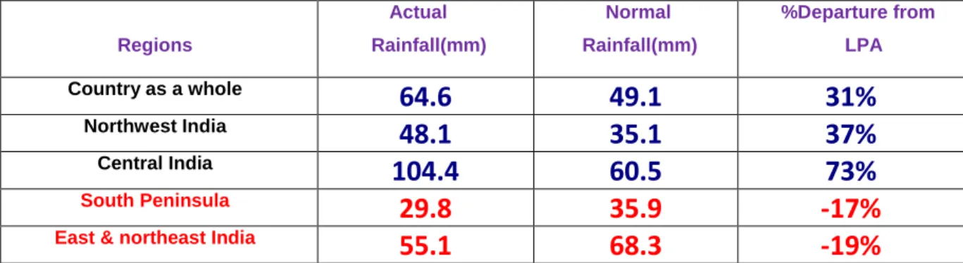
Cumulative rainfall (mm) Actual Normal % Departure Actual Normal % Departure EAST & NORTH-EAST INDIA 55.1 68.3 -19% 1172.1 1143.5 +2%
NORTH-WEST INDIA 48.1 35.1 +37% 451.7 500.2 -10%
CENTRAL INDIA 104.4 60.5 +73% 975.0 815.5 +20%
SOUTH PENINSULA 35.9 -17% +35.9 694.4 576.3 +20%
country as a whole 64.6 49.1 +31% 790.4 723.8 +9%
Sub-division wise weekly and seasonal rainfall distribution is presented in Fig-1 and Fig-2.
Sub-divisionwise daily distribution of realised rainfall is shown in Table-1(A).
Sub-divisionwise departure of realised maximum temperature from Normal is shown in Table-1(C)
Statewise distribution of number of districts with Large-Excesse, Excess, Normal, Deficient, Large-deficient and no rainfall is shown in Table-2.
Cumulative seasonal rainfall data during the corresponding weekly period for the last five years are given in Table-3.
Sub-divisionwise realised weekly rainfall (in cm) is shown in Annexure-1.
FORECAST & WARNING FOR THE NEXT WEEK 03 SEPTEMBER TO 09 SEPTEMBER 2020
Detailed seven days Sub-division wise rainfall-forecast & weather-warning is given in Table-1(B).
Back to Top
Table-1 (A)
METEOROLOGICAL SUB-DIVISIONWISE DISTRIBUTION OF REALISED RAINFALL-2020
S.No. MET.SUB-DIVISIONS 27 AUG 28 AUG 29 AUG 30 AUG 31 AUG 01 SEP 02 SEP
1 ANDAMAN & NICO.ISLANDS ISOL SCT ISOL FWS FWS WS FWS
2 ARUNACHAL PRADESH SCT SCT WS* WS* WS* WS SCT
3 ASSAM & MEGHALAYA ISOL SCT FWS FWS WS* FWS SCT
4 NAGA.MANI.MIZO.& TRIPURA SCT SCT FWS FWS FWS WS* FWS
5 SUB-HIM.W. BENG. & SIKKIM FWS FWS FWS FWS WS* FWS* WS
6 GANGETIC WEST BENGAL WS* WS ISOL ISOL DRY SCT WS*
7 ODISHA WS** FWS SCT ISOL ISOL ISOL WS*
8 JHARKHAND WS* WS ISOL ISOL ISOL ISOL WS*
9 BIHAR SCT FWS SCT DRY ISOL ISOL WS*
10 EAST UTTAR PRADESH SCT SCT SCT ISOL ISOL DRY SCT
11 WEST UTTAR PRADESH ISOL ISOL FWS* SCT ISOL DRY ISOL
12 UTTARAKHAND WS* SCT WS FWS SCT ISOL ISOL
13 HARYANA CHD. & DELHI ISOL ISOL SCT ISOL SCT ISOL ISOL
14 PUNJAB ISOL WS** FWS* ISOL SCT ISOL ISOL
15 HIMACHAL PRADESH WS* WS* FWS ISOL FWS* ISOL ISOL
16 JAMMU & K. AND LADAKH WS* WS** SCT DRY FWS* FWS ISOL
17 WEST RAJASTHAN ISOL ISOL ISOL SCT WS** WS** FWS
18 EAST RAJASTHAN ISOL ISOL SCT WS** WS* SCT ISOL
19 WEST MADHYA PRADESH ISOL FWS* WS** WS** FWS ISOL ISOL
20 EAST MADHYA PRADESH WS* WS** WS** FWS ISOL ISOL ISOL
21 GUJARAT REGION D.D. & N.H. SCT FWS SCT WS* WS* WS* ISOL
22 SAURASTRA KUTCH & DIU FWS* FWS WS* WS** WS** FWS* ISOL
23 KONKAN & GOA WS WS WS* WS* WS* WS FWS
24 MADHYA MAHARASHTRA ISOL SCT FWS FWS* FWS SCT ISOL
25 MARATHAWADA FWS SCT ISOL SCT ISOL DRY ISOL
26 VIDARBHA FWS WS* WS* WS SCT ISOL ISOL
27 CHHATTISGARH WS** WS** WS FWS ISOL ISOL FWS*
28 COASTAL A. PR. & YANAM SCT ISOL SCT SCT ISOL ISOL FWS*
29 TELANGANA FWS* FWS SCT SCT ISOL ISOL ISOL
30 RAYALASEEMA ISOL DRY ISOL ISOL FWS** ISOL FWS*
31 TAMIL. PUDU. & KARAIKAL SCT ISOL ISOL ISOL SCT FWS* FWS**
32 COASTAL KARNATAKA ISOL FWS WS WS* WS SCT FWS
33 NORTH INT.KARNATAKA ISOL ISOL ISOL SCT SCT ISOL SCT
34 SOUTH INT.KARNATAKA ISOL ISOL ISOL ISOL SCT FWS* WS*
35 KERALA & MAHE ISOL ISOL ISOL ISOL ISOL FWS FWS
36 LAKSHADWEEP DRY SCT FWS WS DRY FWS WS
LEGENDS:
WS WIDE SPREAD / MOST PLACES (76-100%) FWS FAIRLY WIDE SPREAD / MANY PLACES (51% to 75%)
SCT SCATTERED / FEW PLACES (26% to 50%) ISOL ISOLATED (up to 25%) D/DRY NO STATION REPORTED RAINFALL
* ACTIVE (R/F 11/2- 4 times the normal with WS/FWS, at least 2 stations should be 5 cm. along west coast & 3 cm. elsewhere )
** VIGOROUS (R/F More than 4 times the normal with WS/FWS, at least 2 stations should be 8 cm. along west coast & 5 cm. elsewhere)
Back to Top
Table-1 (B)
METEOROLOGICAL SUB-DIVISIONWISE WEEKLY RAINFALL FORECAST & Wx. WARNINGS-2020
Sr. No MET.SUB-DIVISIONS 03 SEP 04 SEP 05 SEP 06 SEP 07 SEP 08 SEP 09 SEP
1 ANDAMAN & NICO.ISLANDS FWS FWS FWS FWS FWS FWS FWS●
2 ARUNACHAL PRADESH SCT FWS●TS WS●TS FWS FWS FWS FWS●
3 ASSAM & MEGHALAYA SCTTS FWS●TS WS●TS FWS FWS● FWS● FWS●
4 NAGA.MANI.MIZO.& TRIPURA SCTTS SCTTS FWS●TS FWS FWS● FWS● FWS● 5 SUB-HIM.W. BENG. & SIKKIM SCT FWS●TS WS●TS WS●●TS WS● WS● WS●
6 GANGETIC WEST BENGAL SCT ISOL SCT●TS FWSTS FWSTS FWS FWS
7 ODISHA SCTTS ISOL SCTTS FWS● FWS FWS FWS
8 JHARKHAND ISOL ISOL SCT SCT●TS FWSTS FWS FWS
9 BIHAR SCT ISOL SCT FWS●TS WS●TS WS● WS●
10 EAST UTTAR PRADESH SCTTS SCTTS SCT FWS● FWS● FWS● FWS●
11 WEST UTTAR PRADESH FWS●TS SCTTS SCT SCT SCT SCT SCT
12 UTTARAKHAND WS●TS FWS● SCT● FWS● FWS● FWS SCT
13 HARYANA CHD. & DELHI SCT●TS SCT ISOL ISOL DRY DRY ISOL
14 PUNJAB SCTTS SCT ISOL ISOL DRY DRY DRY
15 HIMACHAL PRADESH WS●TS FWS● SCT SCT ISOL DRY DRY
16 JAMMU & K. AND LADAKH SCTTS SCT ISOL ISOL DRY DRY DRY
17 WEST RAJASTSAN FWS●TS FWS● ISOL ISOL ISOL DRY DRY
18 EAST RAJASTSAN FWS●TS FWS● SCT SCT SCT ISOL ISOL
19 WEST MADHYA PRADESH FWS● SCT ISOL ISOL SCT FWS● FWS●
20 EAST MADHYA PRADESH SCT SCT ISOL ISOL SCT FWS● FWS●
21 GUJARAT REGION D.D. & N.H. ISOL ISOL ISOL ISOL DRY DRY DRY
22 SAURASTRA KUTCH & DIU ISOL ISOL ISOL ISOL DRY DRY DRY
23 KONKAN & GOA FWS●TS FWS●TS FWSTS FWSTS FWSTS FWS SCT
24 MADHYA MAHARASHTRA SCTTS FWS●TS FWS●TS FWS●TS SCTTS SCT SCT
25 MARATHAWADA ISOLTS SCTTS FWSTS FWSTS SCT SCT SCT
26 VIDARBHA ISOL ISOL SCT SCT SCT SCT FWS
27 CHHATTISGARH SCTTS SCT SCTTS SCTTS FWS●TS FWS● FWS●
28 COASTAL A. PR. & YANAM SCTTS SCTTS SCT SCT FWS● FWS● FWS●
29 TELANGANA SCTTS SCT SCT SCTTS FWS●TS FWS● FWS
30 RAYALASEEMA SCT SCT SCT SCT FWS● FWS● FWS●
31 TAMIL. PUDU. & KARAIKAL FWS●TS FWS●TS FWS●TS SCT●TS SCT●TS SCT● SCT●
32 COASTAL KARNATAKA WS●●TS WS●TS WS● WS● WS● WS● WS●
33 NORTH INT.KARNATAKA WS●TS FWSTS FWS FWS● WS● FWS● FWS●
34 SOUTH INT.KARNATAKA WS●TS WS●TS WS● WS● WS● WS● WS●
35 KERALA & MAHE WS●TS WS●TS FWS●TS WS● WS● WS● WS●
36 LAKSHADWEEP WS● FWS FWS FWS FWS FWS FWS
LEGENDS:
WS WIDE SPREAD / MOST PLACES (76-100%) FWS FAIRLY WIDE SPREAD / MANY PLACES (51% to 75%)
SCT SCATTERED / FEW PLACES (26% to 50%) ISOL ISOLATED (up to 25%) D/DRY NIL RAINFALL
●Heavy Rainfall (64.5-115.5 mm) ●●Heavy to Very Heavy Rainfall (115.6-204.4 mm) ●●●Extremely Heavy Rainfall (204.5 mm or more)
FOG * SNOWFALL #HAILSTORM - COLD WAVE (-4.5 OC to -6.4 OC) -- SEVERE COLD WAVE (< -6.4)
$TSUNDERSTORM WITS SQUALL/GUSTY WIND DS/TSDUST/THUNDERSTORM + HEAT WAVE (+4.5 OC to +6.4 OC) ++ SEVERE HEAT WAVE (> +6.4)
Back to Top
Table-1 (C)
METEOROLOGICAL SUB-DIVISIONWISE REALISED MAXIMUM TEMPERATURE-2020
S.No MET.SUB-DIVISIONS 27 AUG 28 AUG 29 AUG 30 AUG 31 AUG 01 AUG 02 SEP
1 ANDAMAN & NICO.ISLANDS N N N N N N N
2 ARUNACHAL PRADESH N N N N N N N
3 ASSAM & MEGHALAYA AN AN N N N N N
4 NAGA.MANI.MIZO.& TRIPURA N N N N N N AN
5 SUB-HIM.W. BENG. & SIKKIM N N N AN N N N
6 GANGETIC WEST BENGAL N N AN N N N N
7 ODISHA N N AN AAN N N N
8 JHARKHAND N N AN AAN N N N
9 BIHAR N N AN AN AN N N
10 EAST UTTAR PRADESH N N N N AN N N
11 WEST UTTAR PRADESH N N N N N N N
12 UTTARAKHAND N N N N N AN AN
13 HARYANA CHD. & DELHI N N N ABN N N N
14 PUNJAB N N N N N N N
15 HIMACHAL PRADESH N N N N N N N
16 JAMMU & K. AND LADAKH N N N N N N N
17 WEST RAJASTHAN N N N N MBN ABN N
18 EAST RAJASTHAN N N N N N N N
19 WEST MADHYA PRADESH N N N N N AN N
20 EAST MADHYA PRADESH N N N N N AN N
21 GUJARAT REGION D.D. & N.H. N N N ABN N N N
22 SAURASTRA KUTCH & DIU N N N N N N AN
23 KONKAN & GOA N N N N N N AN
24 MADHYA MAHARASHTRA N N N N N AN N
25 MARATHAWADA N N N N AN N AN
26 VIDARBHA N N ABN N N AN AN
27 CHHATTISGARH ABN N N N AAN AAN N
28 COASTAL A. PR. & YANAM N N N N N AN N
29 TELANGANA N N N N N AN AN
30 RAYALASEEMA N N N AN N N N
31 TAMIL. PUDU. & KARAIKAL N N N N N N N
32 COASTAL KARNATAKA N AN N N N AN AN
33 NORTH INT.KARNATAKA N N N N AN AN AN
34 SOUTH INT.KARNATAKA N AAN N AAN AN N N
35 KERALA & MAHE N N AN AAN N AN AN
36 LAKSHADWEEP N N N N N N N
Highest Maximum Temperature (°C) 36.0 38.1 38.8 38.2 36.0 37.5 37.0
Station(/s) observed HMT Narsingpur Churu Tiruchirapalli Madurai Narsingpur K Paramathi K PMT, North LKR,Golaghat Station(/s) lies in Met-Subdivision(/s) East M.P. West Rajasthan Tamil Nadu Tamil Nadu East M.P. Tamilnadu
Tamilnadu, Assam &
Meghalaya LEGENDS:
N NORMAL (N+1,N-1)OC BN BELOW NORMAL (N-2)OC ABN APRECIABLY BELOW NORMAL (N-3.1 to -4.9)OC AN ABOVE NORMAL (N+2)OC MBN MARKEDLY BELOW NORMAL (N-5 AND BELOW ) OC AAN APRECIABLY ABOVE NORMAL (N+3.1 to +4.9)OC MAN MARKEDLY ABOVE NORMAL (N+5 AND ABOVE ) OC
* Cold wave conditions (Departure from Normal is( -4 OC to -5 OC and -5 OC to -6 OC) ** Severe Cold wave conditions (Departure from Normal is( -6 OC or less and -7 OC or less )
+ Heat wave conditions (Departure from Normal is (+4.5 OC to +6.4 OC) ++ Severe Heat wave conditions (Departure from Normal is (> +6.4 OC)
3 Back to Top
Table-2
STATEWISE DISTRIBUTION OF NO. OF DISTRICTS WITH EXCESS, NORMAL,DEFICIENT,SCANTY AND NO RAINFALL
S. STATES PERIOD FROM : 01.06.2020 TO 02.09.2020
NO. LE E N D LD NR ND TOTAL
1 A & N ISLAND (UT) 0 1 1 1 0 0 0 3
2. ARUNACHAL PRADESH 1 2 7 6 0 0 0 16
3. ASSAM 2 8 13 2 2 0 0 27
4. MEGHALAYA 2 1 4 0 0 0 0 7
5. NAGALAND 0 1 4 6 0 0 0 11
6. MANIPUR 0 1 1 5 2 0 0 9
7. MIZORAM 0 0 1 7 0 0 0 8
8. TRIPURA 0 0 2 2 0 0 0 4
9. SIKKIM 1 1 1 1 0 0 0 4
10. WEST BENGAL 0 2 17 0 0 0 0 19
11. ODISHA 0 9 19 2 0 0 0 30
12. JHARKHAND 0 4 12 8 0 0 0 24
13. BIHAR 0 16 20 2 0 0 0 38
14. UTTAR PRADESH 1 7 33 32 2 0 0 75
15. UTTARAKHAND 1 1 5 6 0 0 0 13
16. HARYANA 0 4 11 5 1 0 0 21
17. CHANDIGARH (UT) 0 0 1 0 0 0 0 1
18. DELHI 0 1 4 3 1 0 0 9
19. PUNJAB 0 4 10 6 0 0 0 20
20. HIMACHAL PRADESH 0 2 6 3 1 0 0 12
21. JAMMU & KASHMIR(UT) 0 0 8 9 3 0 0 20
22. LADAKH(UT) 0 0 0 1 1 0 0 2
23. RAJASTHAN 0 9 17 7 0 0 0 33
24. MADHYA PRADESH 0 18 30 3 0 0 0 51
25. GUJARAT 13 7 11 2 0 0 0 33
26. DADRA & NAGAR HAVELI (UT) 0 0 1 0 0 0 0 1
27. DAMAN & DIU (UT) 1 0 1 0 0 0 0 2
28. GOA 0 2 0 0 0 0 0 2
29. MAHARASHTRA 4 11 18 3 0 0 0 36
30. CHHATISGARH 1 5 20 1 0 0 0 27
31. ANDHRA PRADESH 5 4 3 1 0 0 0 13
32. TELANGANA 13 8 12 0 0 0 0 33
33. TAMILNADU 8 15 7 2 0 0 0 32
34. PUDUCHERRY (UT) 1 1 1 1 0 0 0 4
35. KARNATAKA 9 11 10 0 0 0 0 30
36. KERALA 0 0 10 4 0 0 0 14
37. LAKSHADWEEP (UT) 0 1 0 0 0 0 0 1
TOTAL 63 157 321 131 13 0 0 685
CATEGORYWISE DISTRIBUTION
OF DISTRICTS OUT OF THE 9% 23% 47% 19% 2% 0%
685 WHOSE DATA RECEIVED
PERCENT DISTRIBUTION OF DISTRICTS IN EARLIER YEARS SINCE 1st JUNE
DATE LE E N D LD NR
04.09.2019 4% 16% 44% 33% 3% 0%
05.09.2018 2% 15% 47% 34% 2% 0%
30.08.2017 5% 13% 48% 32% 2% 0%
31.08.2016 0% 19% 47% 32% 2% 0%
02.09.2015 0% 13% 41% 42% 4% 0%
4 Back to Top
Table-3
RAINFALL DURING MONSOON SEASON
S.
No.
Meteorological Sub-Divisions
For the period from 1st June to