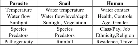
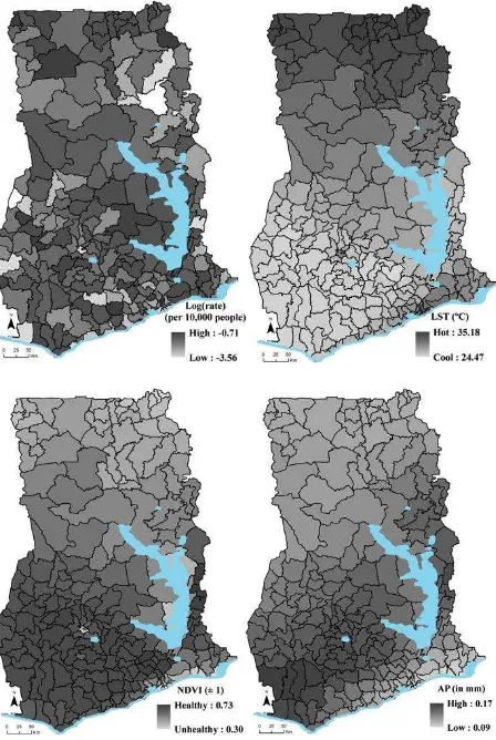
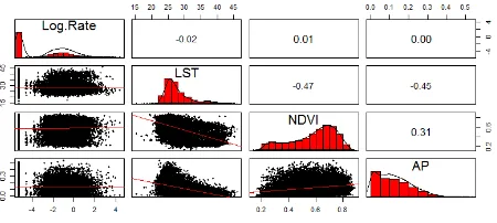
isprs archives XLI B8 215 2016
Teks penuh
Gambar
Garis besar
Dokumen terkait
The proportion of bare land (PLAND2) and the proportion of forest land (PLAND5) are effective and important factors which affect the changes of surface net radiation all the
Our study shows that the relationships between NDVI, average ground air temperature and precipitation sums averaged by growing seasons are the same in the cases of
Multi- temporal series of SPOT VEGETATION NDVI dataset and meteorological data were integrated to interpret vegetation dynamics and the linkage with climate variations in the upper
The objective of this study is twofold: (1) determining the total burn severity of the Mersin- Gülnar wildfire in Turkey by using remote sensing based spectral indices, and (2)
Based on RS-composite classification, DEM-based forest growing conditions types and field data the maps of forest cover and forest ecosystem carbon stock were created...
Tree height-dbh model residuals probably reduce the correlation between lidar canopy height indices and ground AGB reference, consequently introducing errors to
Satellite observations of Earth’s time - variable gravity field from the Gravity Recovery and Climate Experiment (GRACE) mission, which enable direct measurement of
This study validated monthly TRMM 3B43 precipitation images from 14 INAMHI rain gauges located in the Coastal plains (4 stations), Andean highlands (6 stations) and Amazonian
