isprsarchives XL 7 W3 1283 2015
Teks penuh
Gambar
Garis besar
Dokumen terkait
Classification and extraction of spatial features in urban areas using high- resolution multi-spectral imagery, IEEE Geoscience and Remote Sensing Letters ,
In consideration of the spatial resolution of these sensors and the size of the target, with the aid of data measured with optical sensor onboard GF-1
It is already necessary to make a compromise between spatial and temporal resolution – if the data are available in high temporal resolution (from geostationary
A ROBUST FALSE MATCHING POINTS DETECTION METHOD FOR REMOTE SENSING IMAGE REGISTRATIONX.
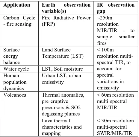
KEY WORDS: Small Satellite Constellation, Infrared Instruments, High Temperature Events, impact on the climatic processes, Bi- Spectral Method, Advanced On Board
This paper examines whether improved temporal sampling at high spatial resolution (20m) with satellite data actually improves our knowledge of deforestation and
Remote sensing is a suitable tool for estimating the spatial variability of crop canopy characteristics, such as canopy chlorophyll content (CCC) and green
Our study contains two main parts: urban viaducts recognition and topology reconstruction. The International Archives of the Photogrammetry, Remote Sensing and
