PRELIMINARY STUDY ON THE RADAR VEGETATION INDEX (RVI) APPLICATION
TO ACTUAL PADDY FIELDS BY ALOS/PALSAR FULL-POLARIMETRY SAR DATA
Y. Yamada a
a National Agriculture and Food Research Organization (NARO), NARO Institute for Rural Engineering, 2-1-6, Kannondai,
Tsukuba, 305-8609 Japan
The International Archives of the Photogrammetry, Remote Sensing and Spatial Information Sciences, Volume XL-7/W3, 2015 36th International Symposium on Remote Sensing of Environment, 11–15 May 2015, Berlin, Germany
This contribution has been peer-reviewed.
NRCS = 10 * log10 (DN2) + CF
RVI = (8 *
The International Archives of the Photogrammetry, Remote Sensing and Spatial Information Sciences, Volume XL-7/W3, 2015 36th International Symposium on Remote Sensing of Environment, 11–15 May 2015, Berlin, Germany
This contribution has been peer-reviewed.
Figure 6. August 15th, 2006
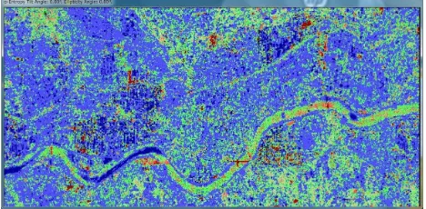
Results of conventional full-polarization SAR data analysis are indicated the following figures.
Figure 7. Pauli decomposition (R:HH G:HV B:VV)
Figure 8. Pauli basis (R: HH-VV G: HV B:HH+VV)
Figure 9. α, Entropy decomposition
Figure 10. 4-component decomposition
6. CONCLUSION
(1) Kim and Jackson pointed out that Radar Vegetation Index is highly correlated with NDVI. But the width of ridges of rice plants in the Japanese paddy fields is systematic arrangement to know the growing stage of rice plants.
(3)As the ALOS-2/PALSAR2 is L-band SAR, it will be possible to know the paddy rice grow in Asian countries.
REFERENCES
Isoguchi, O. and Shimada,M., 2007. An L-band model function for the ocean-normalized radar cross section derived from PALSAR, Proceedings of the first joint PI symposium of ALOS data nodes for ALOS science program in Kyoto, OCS09, pp.1-4
Lee,J. and Pottier,E. 2009. Polarimetric Radar Imaging from Basics to Applications, CRC press, pp.179-253,254-300
Ulaby,F.T. and Long,D.G., et al., 2014. Microwave Radar and Radiometric Remote Sensing, pp.216, 221, 499,567
Yihyun Kim, Thomas Jackson, et al.,
The International Archives of the Photogrammetry, Remote Sensing and Spatial Information Sciences, Volume XL-7/W3, 2015 36th International Symposium on Remote Sensing of Environment, 11–15 May 2015, Berlin, Germany
This contribution has been peer-reviewed.