Conference paper
Teks penuh
Gambar
Garis besar
Dokumen terkait
Since the color and texture of vegetation in different regions of the TM image are not always the same, and the single band SAR image is difficult to be classified as different
The detection employs extracted façade structures from images and height gradients from a projected 3D point cloud generated from that image pair.. 2.2.1 Façade structures: façade
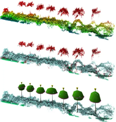
Figure 13: Projected (top) and colored (bottom) point cloud using original calibration (left) and relative orientation given by resec- tion (right).. Figure 14: Projected (top)
In this paper, a color-enhanced hybrid segmentation model based on the region growing method is proposed for RGB-D camera- based indoor mobile mapping point cloud planar surface
Color coding: cyan - image line segments detected in current frame corresponding to a model edge, blue - image line segments tracked as correspondences from the previous frame..
The test scenes can be used to evaluate the quality of the 3D re- construction (e.g. by comparing the resulting point cloud to the ground truth available for the two 3D
Each segment reveals similar color and height, and it is possible that one actual building segment may be divided into several segments during the segmentation process,
The relationship of average landuse intensity with altitude, slope gradient and slope aspect is very high which shows that geomorphic variables have greater role
