isprs annals III 4 33 2016
Teks penuh
Gambar
Dokumen terkait
Generally, it first generates a grid-based occupancy likelihood map based on all previous scans, and then applies the scan-to-map matching to find the optimal rigid-body
Specifically, the proposed method builds on a novel concept of local support-based filtering of outliers, which enables the use of six degrees-of-freedom (DoF) simultaneous
90% of top ten cities on the number of publishing papers are capital cities or municipalities directly under the central government.In conclusion, we found that the research focus
2.3.1 E-buffer based Approach: To understand the conceptual idea of using the e-buffer image for visibility analysis, the following processing is designed for hidden detection
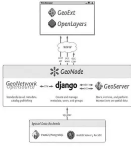
These collected and created geo-datasets and maps are then published, including a Digital Object Identifier (DOI) to facilitate scholarly reuse and citation of the data, in a web
The CityGML-based semantic city model of Meidling is itself the product of a data harmonisation and integration process and acts as a prerequisite for the work described
Another important issue is the navigation aid for ordinary road users after traffic incidents occur. Because the hazards caused by the incidents could make certain roads blocked,
To reflect the increasing inter-dependence and integration between urban data (always the core focus of UDMS), information and technology for Smart Cities, UDMS has decided to
