isprsarchives XL 5 W5 139 2015
Teks penuh
Gambar
Dokumen terkait
The gradient sparsity MAP deconvolution takes 9 s on the image in Figure 2, while the non-blind deconvolution Richardson-Lucy al- gorithm with the blur kernel set by the
The second step uses the ladders to estimate the vertical correction: we proposed a robust method based on M-estimation to fit lines on the bars and rungs of the ladder using the
With respect to the subject studies, topographic and bathymetric surveying of the coastal area of Sabratha archaeological site were conducted between the end of March and
This article surveys the salient features of the regional forms and styles of the Ionian cities of Chios, Clazomenai, Lesbos, Miletus, and Samos (Figure 1), in the
The ISCR Unit of underwater archaeology in the past years have focused its efforts to test 3D documentation systems, as the three-dimensional survey of the sarcophagi of
Finally, the third case study concerns the merging of data acquired by the dense stereo mapping and by a multi-beam sonar in order to improve the understanding of the acquired
measurement principle for underwater 3D application is shown, and potential applications are discussed. His contribution is the proof of the suitability of the measurement
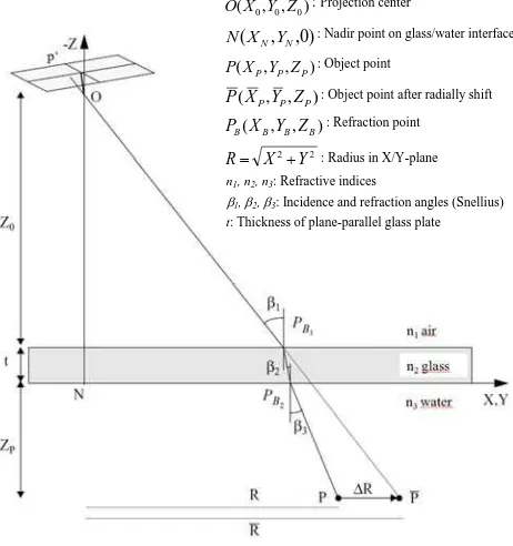
It is apparent, that in two media photogrammetry, the 1.33 factor used for clean water in underwater cases does not apply and the relation of the effective
