Change the parking rates applicable to the Castle Hill North Precinct to reflect the controls published by the department within the Council's LEP. Adjust parking rates for the Castle Hill North Precinct to reflect controls published by the department within the Council's LEP.
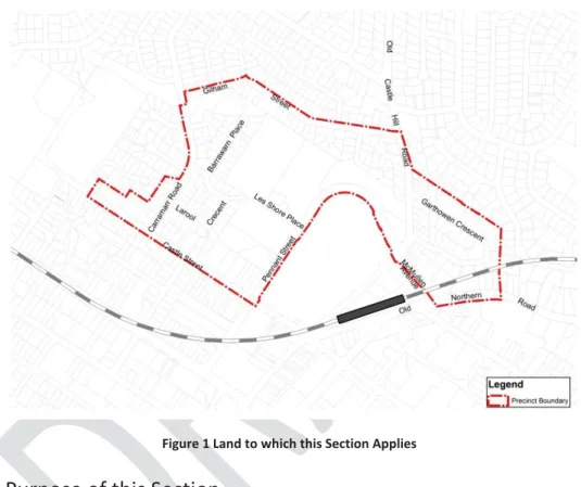
Land to which this Section applies
This section establishes a framework and controls to guide development in Castle Hill North Precinct (the Precinct).
Purpose of this Section
Relationship to other Sections of the DCP
Vision
Development principles
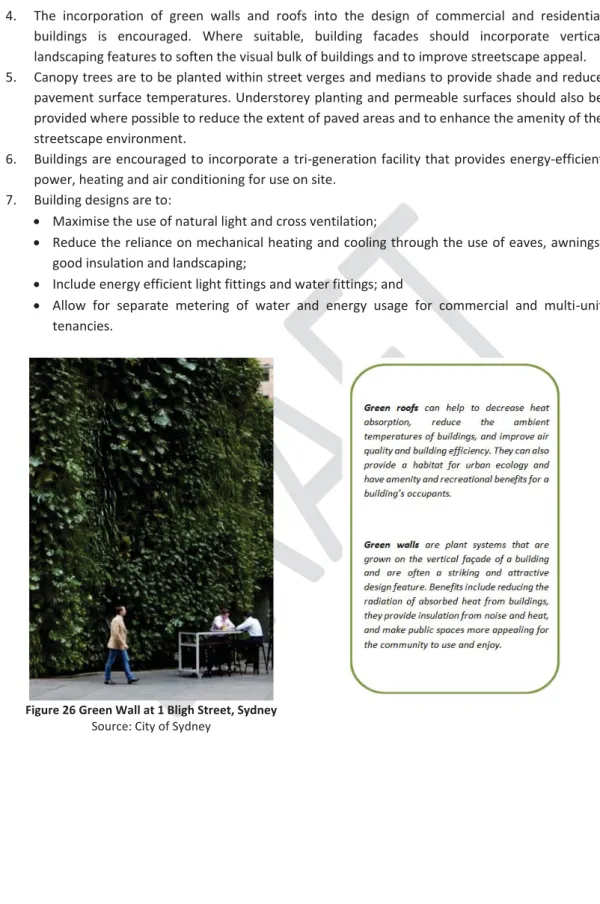
Placemaking will be a key focus to give neighborhoods that are sustainable, accessible, safe, attractive and well-maintained a unique character and sense of place. Streets will be enlarged where possible with new public domain treatments, including new paving, new street furniture and lighting, improved pedestrian access and special plantings of street trees.
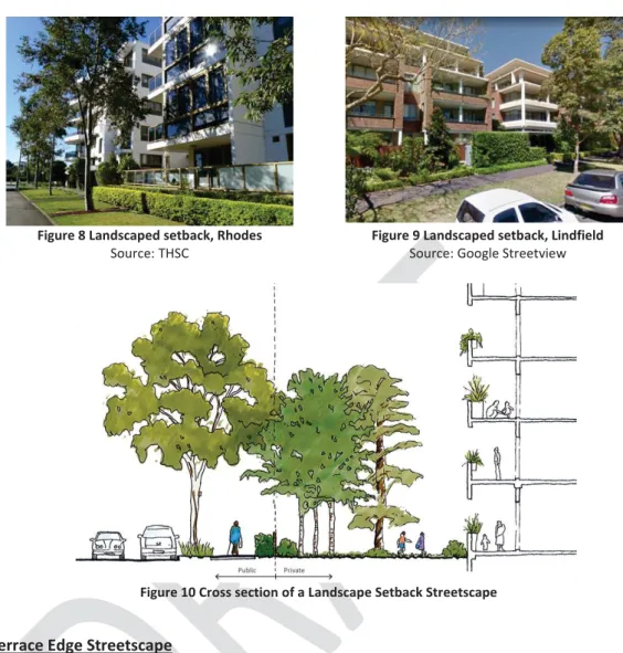
Desired Future Streetscape Character
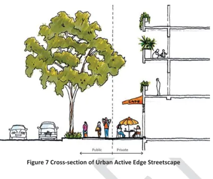
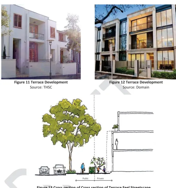
The 'Urban Active Edge Streetscape' applies to streets near the railway station and Castle Hill Centre. Where terraces are proposed along these streets they will have smaller setbacks and will address the 'Terrace Edge Streetscape' street frontage elements.
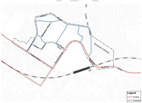
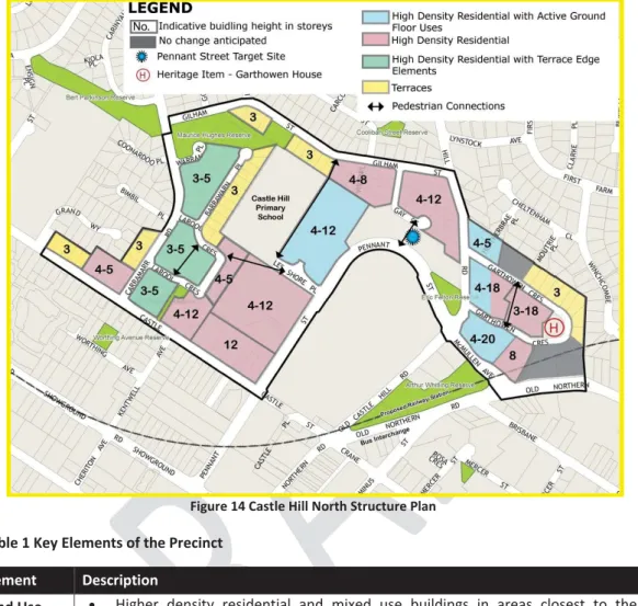
Castle Hill North Precinct Structure Plan and Key Elements
Land use x Higher density residential and mixed-use buildings in areas closer to the station. Junction treatments including roundabouts at Carramarr Road/ Castle Street, Gilham Street/ Carramarr Road, Gilham Street/ Old Castle Hill Road and Garthowen Crescent/ Old Castle Hill Road.
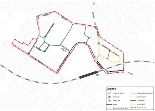
Movement Network and Design
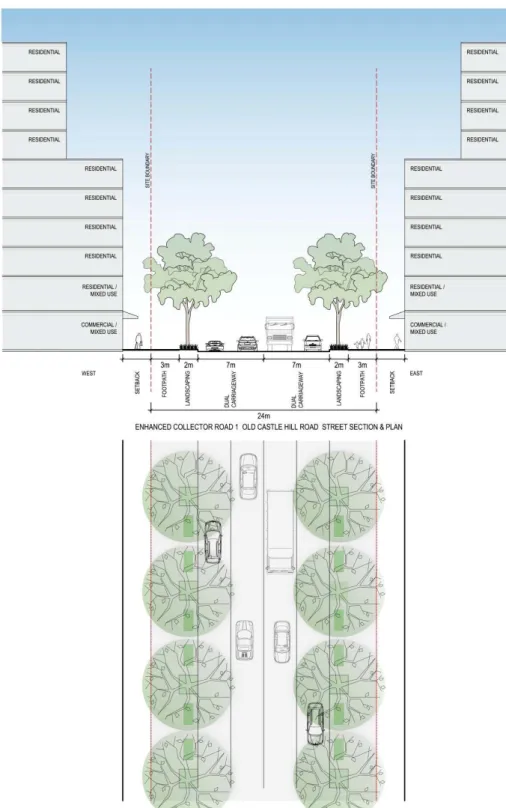
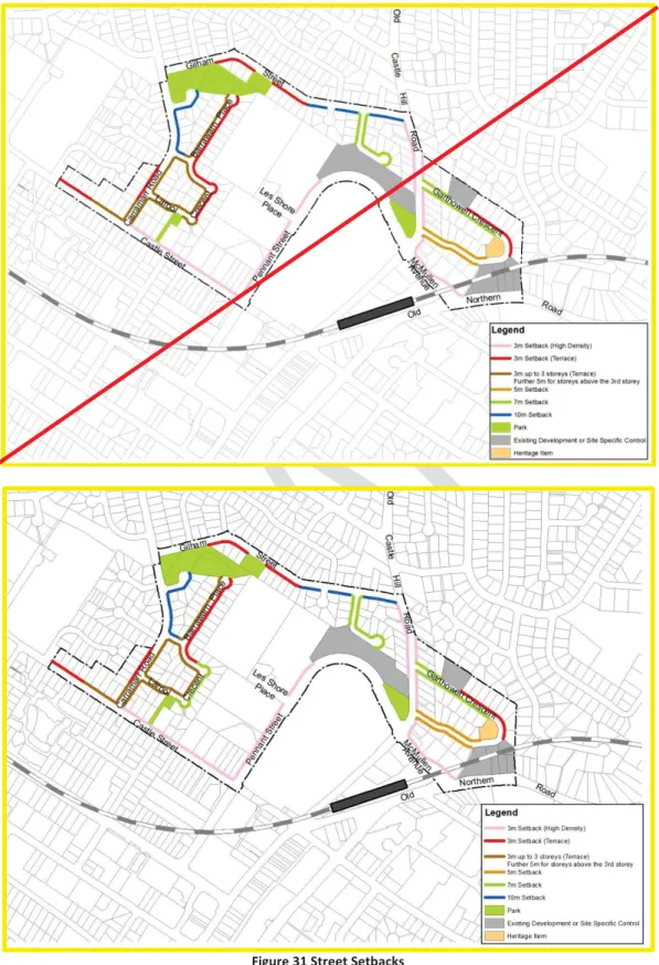
Land along the northern side of Castle Street and along both the eastern and western sides of Old Castle Hill Road, as identified in the Castle Street and Old Castle Hill Road - Road Widening Plans (Figures 23-25) will be acquired by the Council for road. widening.
Public Domain
Attractive, high-quality outdoor spaces where children can play are integrated into the public domain of the centers where necessary. The Council will require, as a condition of any development permit, that all existing overhead power grids be moved underground, with the exception of main transmission lines.
Integrated Water Management
WSUD should be applied during all development, including water quality management and reduction of runoff to acceptable levels after development. Detention on site must be realized in accordance with paragraph 4.22 of the Council's Draft Guidelines for Land Development / Developments.
Cut and Fill
Ecologically Sustainable Development
Where possible, undergrowth and permeable surfaces should also be provided to reduce the amount of paved areas and enhance the amenity value of the streetscape. Buildings are encouraged to incorporate a three-generation installation that provides energy-efficient power, heating and air conditioning for on-site use.
Ecology
Safety & Security
Heritage (Garthowen House)
Site Requirements
This should include the applicant providing an envelope for that site, indicating height, building form, setbacks and separations (building and basement) sufficient to understand the relationship between the proposed development and the isolated site and the streetscape implications. The development of an isolated site must not detract from the character of the streetscape and is to achieve a satisfactory level of amenity including solar access, visual and acoustic privacy.
Setbacks (Building and Upper Level)
For all buildings, in a street reservation equal to or greater than 20m in width (Old Castle Hill Road and Castle Road), all storeys above the 6th floor shall be set back 6m behind the front of the building. For all buildings on a road reservation less than 20 m wide, all floors above the 4th floor shall be 6 m behind the front line of the building.
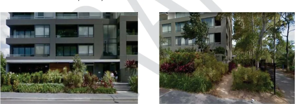
Open Space and Landscaping
Native ground covers and grasses should be used in garden beds and path surrounds (terrain should be limited to usable outdoor areas). Drought-tolerant plant species and species that improve habitat and ecology should be prioritized.
Built Form Design
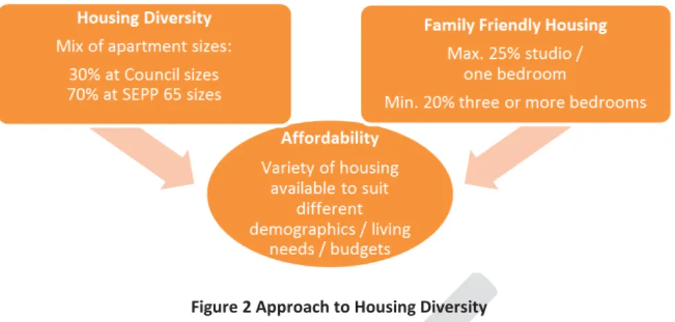
No more than 25% of the total number of apartments (to the nearest whole number of apartments) contained in the project shall be studios or 1-bedroom apartments or both and. At least 20% of the total number of dwellings (to the nearest whole number of dwellings) contained in the development must be dwellings of 3 or more bedrooms.
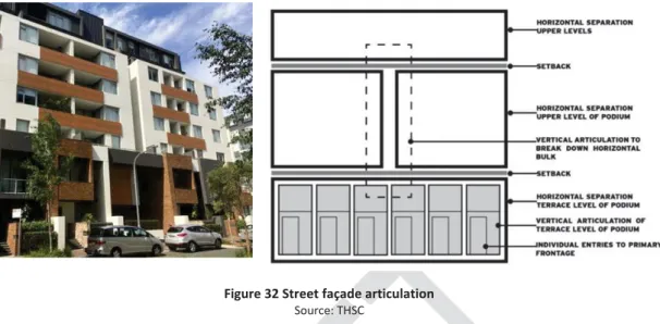
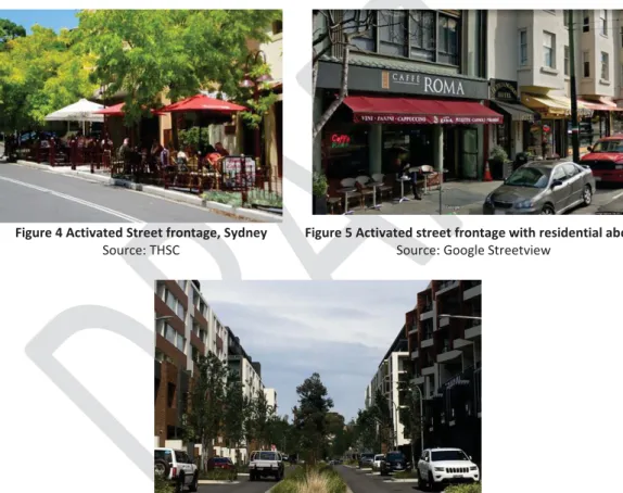
Active Street Frontages
Continuous awnings should be provided above the retail areas and along the entire length of the active facades. Where an active facade is required, at least 80% of the building facade must be transparent (ie windows and glazed doors).
Streetscape and the Public Domain Interface
Retail and commercial uses at ground level shall be designed so that the ground floor for at least a portion of the premises is flush with the finished grade of the adjacent roadway and/or open space. Lighting shall be provided for safety at night for all public and semi-public access roads.
Residential Uses on Ground and First Floors
Solar Access and Overshadowing
Adaptable housing
Residential buildings must meet the requirements for adaptable dwellings in Part B, Section 5 Residential Buildings of The Hills DCP 2012. All types of dwellings must consider flexibility in design to allow adaptation to meet the changing needs of residents due to aging or disability.
Noise
Wind
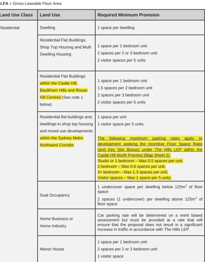
Parking Rates and Access
Parking spaces must be provided at the prices listed in the parking price table below. The undertaking must be registered on the strata plan, which lists each shared car parking space.
Site Requirements
This section of the DCP applies to land in the R3 Medium Density Residential Zone. Development specified in this section of the DCP, which is a Torrens Title subdivision, will be required to comply with the requirements of clause 4.1B Exceptions to Minimum Lot Sizes for Specified Development under the Hills Local Environmental Plan 2012.
Building Setbacks
Front joint zone x Smaller facade elements such as balconies, porches or verandas can be 1 m in front of the front building line. Must comply with the setback requirements contained in The Hills DCP 2012 (Part B, Section 4 – Multi Dwelling Housing).
Open Space and Landscaping
Between 9 a.m. and 3 p.m. on June 21, at least 50% of the required free space per home and adjacent homes must receive direct sunlight for at least 3 hours. A collapsible or permanent clothes dryer should be placed in private open areas and positioned to maximize the amount of direct sunlight.
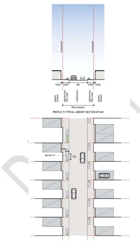
Rear Laneways
The avenue is a public "partway" as the paved surface is designated for cyclists, pedestrians and cars, etc., with a 10 km speed limit and ramp style crossings to the street rather than an intersection. The minimum garage door opening widths for maneuverability in this lane section are 2.4m (single) and 4.8m (double). The sightlines of the access road end with landscaping or the continuation of the avenue.
Lane roads that create a "front-to-back" layout (primary residences with front address on one side and rear-access garages on the other) should be avoided. Terraces will be designed to facilitate passive surveillance along the rear lane through the positioning of windows and balconies facing the street. A concrete bin pad 1.7m wide and 0.8m deep will be provided behind the curb and adjacent to the roads for bin placement.
A swept road analysis for the standard 12.5m long HRV (AS) must be submitted demonstrating that all turns of lanes are suitable for turning refuse vehicles. Accordingly, any building elements overhanging the rear lane reservation area will be a impact on the operation of side-mounted waste collection vehicles.
Building Height
Building Design and Streetscape
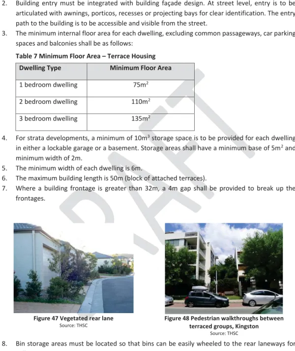
At street level, the entrance should be divided by canvas roofs, porticoes, recesses or projecting bays for clear identification. The entrance to the facility must be accessible and visible from the street. For strata development, a minimum of 10 m3 of storage space in a lockable garage or basement must be provided for each apartment.
Where the building front is greater than 32 m, a gap of 4 m must be provided to break the front faces. Bin deposit areas should be located so that bins can be easily passed to the rear lanes for collection. Hedge and shrub planting or open style fencing should be provided along the road frontage.
Rear lanes to allow for low maintenance soft landscape treatments to reduce the impact of hard surfaces and wall treatments.
Car Parking
The purpose of this report is to consider the results of the public disclosure of the North Castle Hill Planning Proposal (16/2016/PLP), the Draft Contributions Plan, the Draft Sections of the Development Control Plan (North Castle Hill and Car Park) and the Draft Public Domain Plan. Notices were sent to 11 public bodies and all landowners within and adjacent to the northern Castle Hill area (3,733 landowners) and landowners adjacent to the proposed Glenhaven playing fields (537 landowners). The LAHC opposed the application of the residential diversity provision to public housing.
It is not proposed to widen the Carramar Road road reservation as part of the Castle Hill North planning proposal. Matters relating to the provision of playing fields to meet future population demand within the Castle Hill North Precinct are discussed in section 5(d) of this report. Land within the displayed boundary of the Castle Hill North Precinct has been the subject of lengthy and extensive master planning for a number of years.
The application of the standards applicable to the target site will enable additional use over that envisaged for the site in the Castle Hill North planning proposal. This will happen as part of a masterplan for the rest of Castle Hill and Cherrybrook Precinct. Accordingly, the proposed changes are no longer required as part of the Castle Hill North planning proposal.
The Contribution Plan for Castle Hill North will fund a portion of the facility commensurate with the expected population growth (refer table below). Acknowledge that these properties are not proposed to be up-zoned as part of the Castle Hill North planning proposal. Street setbacks for the site must be consistent with those proposed as part of the site specific planning proposal.
The planning proposal was not referred to the local planning panel under section 2.19(1)(b) of the Act.