CONFERENCE COMMITTEE
Coordinator : Yandra Arkeman, Dr. M.Eng
(Departement of Agroindustrial Technology, IPB) Co-Coordinator : Nastiti Siswi Indrasti, Prof. Dr. Ir.
(Head of Departemen of Agroindustrial Technology, IPB)
International Experts:
1. Kenneth De Jong, Prof.
(George Mason University, Fairfax, Virginia, USA) 2. Kim Bryceson, Prof.
(School of Agriculture and Food Science , University of Queensland, Australia) 3. Haruhiro Fujita, Prof.
(Department of Information Systems, Niigata University for International and Information Studies Japan)
4. Gajendran Kandamsany, Dr. (United Kingdom)
5. Noel Lindsay, Prof. (University of Adelaide, Australia)
Committee Members from IPB: 1. Kudang Boro Seminar, Prof.
(Departement of Mechanical & Bio-system Engineering, IPB) 2. Marimin, Prof.
(Departement of Agroindustrial Technology, IPB) 3. Endang Gumbira Said, Prof.
(Departement of Agroindustrial Technology, IPB) 4. Suprihatin, Prof.
(Secretary of Departement of Agroindustrial Technology, IPB) 5. Ono Suparno, Prof.
(Departement of Agroindustrial Technology, IPB) 6. Agus Buono, Dr.
(Head of Department of Computer Science, IPB)
PROCEEDINGS
2
ndInternational Conference on Adaptive and Intelligent Agroindustry (ICAIA)
September 16 – 17, 2013, IPB International Convention Center
Bogor – Indonesia
Organized by :
WELCOMING ADDRESS
Prof. Dr. Ir. Nastiti Siswi Indrasti
Head of Agroindustrial Technology Department Faculty of Agricultural Engineering and Technology
Bogor Agricultural University
On
Second International Conference on Adaptive and Intelligence Agroindustry (2nd ICAIA)
Bogor, September, 16 – 17, 2013
Assalamu’alaikum Warohmatullahi Wabarokatuh In the name of Allah, the beneficent and the merciful,
Distinguish Guest, Ladies and Gentlemen
Let me first thank you all for accepting the invitation to participate in this 2nd International Conference on Adaptive and Intelligence Agroindustry (ICAIA). In particular I would like to thank Rector of IPB (Institut Pertanian Bogor/Bogor Agricultural University) Prof. Herry Suhardiyanto for supporting this event as part of the series academic event in celebrating the 50th Anniversary of Bogor Agricultural University.
In fact, the idea of organizing this conference was the continuation of the International Workshop on Computational Intelligence and Supercomputing Technology for Adaptive Agroindustry held by the Department of Agroindustrial Technology, Bogor Agricultural University last year.
Professor Kenneth A De Jong from George Mason University, US has successfully conducted joint international research with some staff from the Department of Agroindustrial Technology and Department of Computer Science, Bogor Agricultural University. The research aims to develop an integrated and intelligent system (namely SMART-TIN©) for the design of adaptive agroindustrial system in order to achieve a sustainable agroindustry that can mitigate global climate change and at the same time secure food, water, energy and natural medicine supply.
We are certainly proud to have been able to assemble this event in IPB, Bogor. The range of participants and audience at this conference is precisely something I would like to stress. The main goal of the conference is to provide an effective forum for distinguished speakers, academicians, professional and practitioners coming from universities, research institutions, government agencies and industries to share or exchange their ideas, experience and recent progress in Adaptive and Intelligent Agroindustry.
Distinguish Guest, Ladies and Gentlement,
Global climate change is the most challenging problems for us today and in the near future. This global change in our climate can lead to the shortage of the food, water, bioenergy and natural medicine that will affect the quality of human life. Many studies indicate that the threat of food, water, bioenergy and natural medicine crisis due to global climate change still worries our society. This problem can be solved by the development of agroindustry, i.e. an interrelated value chain entities from farming, to agro-processing industry and then to the end-customers. In fact, the design of agroindustry is complex and involves many factors and large data bases and more importantly, needs a good intelligence to process data and information to good decisions. Therefore, the way to design and manage agroindustry should be improved in order to meet the design objectives.
Agroindustries consume quite significant amount of energy on one side, on the other side they generate sizable amount of industrial wastes and its utilization as a captive energy resource is a kind of potential. Based on our study, a plywood industry with the production capacity of 200.000 m3/year could generate 32 percentage of solid waste. If this amount of waste used as an energy alternative, it may result on the saving of 131.037.768.597 rupiah per month. Similar to plywood industry, sugarcane industry with the production capacity of 480 ton per hour could generate 154 ton per hour of waste (bagasse) and this amount of waste contribute to the saving of energy consuming by 19.250 Kwh. Recent study we conducted, indicated that cassava starch industry may contribute to a significant amount of waste. It has also potential usage as an energy resource. Based on our study the conversion of its waste into energy will contribute to the saving of energy usage of 4100 liter biogas per ton material.
reduced. The new, incremental energy contributions that can be obtained from waste biomass will depend on future government policies, on the rates of fossils fuel depletion, and on extrinsic and intrinsic economic factors, as well as the availability of specific residues in areas where they can be collected and utilized. All of these factors should be in detail examined to evaluate the development of the industrial waste contribution. Hope this conference will also discuss this issue in more detail as it is an important matter for all of us. We should no more think just how to produce high value product but it is also necessarily important how to keep our live in good quality by understanding following old saying…” only when the last tree has been cut, only when the last fish has been angled, and only when the last river has been polluted, then we realized that we could not eat money”.
I do not to take up any more of your time with these opening remarks. Let me simply thank you once again for sharing your thoughts with us. Here’s wishing every success for the conference. May Allah bless all of us.
Thank you for your kind attention,
AGENDA of
2
ndInternational Conference on Adaptive and Intelligent Agroindustry
(ICAIA)
Time Activities Room
Day 1 (16 September 2013)
08.00 – 09.00
Welcoming Address: Prof. NastitiSiswiIndrasti (Head of Dept TIN, Fateta, IPB)
Conference Opening: Prof. HerrySuhardiyanto(Rector of IPB)
o ABET Certification announcement and short ceremony o Launching International Double Degree Master Program in
Innovation and Technopreneurship in Cooperation with University of Adelaide, Australia
o Soft-launching Master in Logistik Agroindustri (Agroindustrial
Logistics)
Ballroom
10.00 – 10.45 (45’)
Opening Speeches:
Prof. IrawadiJamaran (Agroindustry Guru, IPB: 25’) Prof. Eriyatno (Industrial and System Engineering, IPB: 20’)
Ballroom
Session 1 10.45 – 11.15
(30’)
Keynote Speech Dr. YandraArkeman (IPB) Ballroom
11.15 – 12.00 (45’)
Keynote Speech Prof. Kenneth De Jong (George Mason University, USA) Ballroom
12.00 – 13.30 Invited Speakers (1-4) (4 x 20 minutes) Discussion (25 minutes)
Tentative Schedule: Prof. Kim Bryceson (Australia), Prof. SyamsulMa’arif (IPB), Prof. KudangBoro Seminar (IPB), Prof. HaruhiroFujita (Japan)
Ballroom Invited Speakers (5-8) (4 x 20 minutes) Discussion (25 minutes)
Tentative Schedule: Dr. Gajendran (UK), Prof. Noel Lindsay (University of Adelaide), Dr. KuncoroHartoWidodo (UGM), Prof. UtomoSarjonoPutro (ITB)
Ballroom
Day 2 (17 September 2013) 08.00 – 08.30
(30’)
Registration
08.30 – 10.15 (105’)
Moderator: Prof. KudangBoro Seminar (IPB) Invited Speakers (9-12) (4 x 20 minutes) Discussion (25 minutes)
12.30 – 13.30 (60’)
Lunch Break
13.30 – 15.00 (90’)
Open Discussion (Open Forum) with Prof. Kenneth De Jong
Topic: Foundations and Applications of Genetic/Evolutionary Algorithms
Ballroom
15.00 – 15.30 (30’)
Conference Closing Ballroom
15.30 – 17.00 (90’)
Indonesian Agroindustry Association (AGRIN) National Congress (PIC: Prof. Suprihatin)
Ballroom
17.00 – 17.45 (45’)
CONTENT LIST
Conference Committee
Welcoming Address ….……….………... i
Agenda of 2nd ICAIA 2013... iii
Content List …………..………...………... v
A. SMART-TIN© : An Integrated And Intelligent System For The Design Of Adaptive Agroindustry (A Conceptual Framework) (Yandra Arkeman)
1‐9.
B. GHG Emission Reduction By Waste Cooking Oil Recycling In Environmental
Partnership Program Of Bogor City (Haruhiro Fujita, Atsushi Yoshimoto,
Katsuyuki Nakano, Koji Okuhara, Noriaki Koide, Dadang Supriatna)
10‐16.
C. Challenge of Indonesian Logistics Infrastructure for Perishables Products
(Kuncoro Hartoto Widodo, Yandra Rahardian Perdana, Joewono Soemardjito)
17‐28.
D. Design Of Grouping Traditional Market Distribution Using Fuzzy Clustering And
Design of Routing of Packaging Cooking Oil From Distribution Center To
Traditional Market Using Traveling Salesperson Problem– Genetic Algorithm in
Indonesia (Case‐Jakarta) (Teja Primawati Utami, Syamsul Maarif, Yandra
Arkeman, Liesbetini Hartoto)
29‐43.
E. Determining the degree of product rightness at the conceptual stage:A Case of
the Low Cost Green Car (Ade Febransyah, Fransisca Tharia)
44‐53.
F. Co‐Composting Process Of Bagasse And Sludge From Sugarcane Industry With
Influence Of Difference Initial C/N Value And Aeration (Andes Ismayana, Nastiti
Siswi Indrasti, Tori Sane)
54‐62.
G. Analysis Of The Competitiveness Of The Agribusiness Sector Companies Using
Porter's Five Forces (M. Hudori)
63‐72.
H. Design And Optimization Of Agro‐Scm For Food And Energy Security In
Indonesia (Hoetomo Lembito, Kudang Boro Seminar, Nunung Kusnadi, Yandra
Arkeman)
Arifin, A. Fatikunnada)
100‐112.
L. Artificial Neural Network Model Based Capacitance Dielectric For Crackers Self‐
Life Prediction (Erna Rusliana Muhamaad Saleh, Erliza Noor, Taufik Djatna,
Irzaman)
113‐121.
M. Characterizing Temporal Dynamic Of Weather Variability To Support Decision
Making On Weed Control (Rizky Mulya Sampurno, Kudang B. Seminar, Yuli
Suharnoto, Mohamad Solahudin)
N. Risk Management Model in Dairy Product Transportation With Fuzzy Logic
Approach (Winnie Septiani, Yandra Arkeman)
131‐141.
O. Strategy to Increase Institutional Capacity of Farmer Groups to Support the
Transportation System Agroindustry Products (Zulfiandri, Yandra Arkeman)
142‐156.
P. Adsorption Of Carotenoid From Palm Oil Methyl Ester By Using Attapulgite And
Synthetic Silica Magnesium As Adsorbent (Sapta Raharja, Prayoga Suryadarma,
Zuni Fitriyantini)
157‐163.
Q. High Accuracy Agroindustry Environment Monitoring System Based on Photonic
Crystal Sensor Network (Mamat Rahmat, Muhamad Azis, Erus Rustami, Wenny
Maulina, Kudang Boro Seminar, Arief Sabdo Yuwono, Husin Alatas)
164‐174.
R. Study on Effect ofTemperatureIncrease on the Productivity of Methanefrom
POME Fermentation (Sarono, E. Gumbira Said, Ono Suparno, Suprihatin, Udin
Hasanudin)
175‐180.
S. The Design and Implementation of Geographic Information Systems to Support
Food and Energy Security (Arif Purnomo Muji Basuki, Yandra Arkeman,
U. Corncob Biodelignification Process Using White Rot Fungi (Liesbetini Hartoto,
Purwoko, Elis Nina Herliyana, Cucu Rina Purwaningrum)
200‐212.
Technology (Marimin, Mushthofa)
233‐241.
Z. Adaptive Learning Model of Hypergame by using Genetic Algorithm: an
Application of Value Co‐creation in Service System (Case Study: Airline Service)
The Design and Implementation of Geographic Information
Systems to Support Food and Energy Security
Arif Purnomo Muji Basuki
Bogor Agriculture Institute (IPB Bogor)
Departemen of Computer Science and Agriculture Technology Industry [email protected]
Yandra Arkeman
Bogor Agriculture Institute (IPB Bogor)
Departemen of Computer Science and Agriculture Technology Industry [email protected]
Musthofa
Bogor Agriculture Institute (IPB Bogor)
Departemen of Computer Science and Agriculture Technology Industry [email protected]
ABSTRACT
The extensive of oil palm and paddy fields plantations as the development of the area food and bioenergy resources, especially in oil palm could be inversely due to changes in land use. Land capacity analysis is a component of the balance sheet supporting natural resources. Calculating the balance of land resource degradation of land resources due to land use are taken into account included in the land use. The results provide an analysis of food-carrying capacity of land per region has surplus food index category consists Indragiri Hilir, Rokan Hulu, sufficient food consists Indragiri Hulu, Pelalawan, Rokan Hilir, low food consists Singingi Kuantan, Siak, Kampar, Bengkalis, Meranti, Pekanbaru, Dumai based on the ratio of functions in producing bioenergy plantations and agricultural land producing specialized agricultural food production. The capacity of the soil conditions for bioenergy development surplus energy consists of Indragiri Hilir, Pelalawan, Siak, Kampar, Rokan Hulu, sufficient energy condition consists of Singingi Kuantan, Indragiri hulu, Bengkalis, Rokan hilir and low energy conditions consists of Meranti Islands, Pekanbaru and Dumai.
Keywords: The balance of land use, plantation, Geographical Information Systems
1. NTRODUCTION
Indonesia has been known for years as an agricultural country with agricultural resources as its main economy prominent. Having a very large area used for agricultural purposes, Indonesia has a variety of food crops that are seed commodities for its people economy. Throughout years, the food production could not balance the growth of population in a certain area.
The local government, representing the central authority, is reponsible to manage local natural resosurces and address the food problems. The government has to take measures which search for seed food commodities that will increase economy for the local people. Another problem to address is the energy deficiency, particularly fossil fuel, that is used for locals economy distribution.
At the regional level, natural resources are pivotal to improve local people’s welfare. The natural resources, including land, are utilized for public interests, such as agriculture and plantation areas, which are important for local development. When the use of land is not based on the regulations, some problems may occur, particularly in ensuring food and energy sustainability which are important factors that support the local development.
The guidance framework is linked with general diagnose, technological environment and improvement of social economic standard of people. The guidance consists of the following components:
Analysis on agricultural condition, i.e. agricultural land management, starting from the production process, price, stocking and storage, and distribution to the market. Natural resources which can be used for developing food and energy products,
including forests, agriculture, plantation and water. These materials are of the focus of this research.
Technology to develop oil palm biofuel and food made of agriculture corps, such as rice plant, increase the volume of production corps which can fulfil the energy needs, and impacts of the biofuel use to the oil palm plantation environment, such as climate change and greenhouse effect.
Referring to the bio-energy development, Global BioEnergy Partnership (GBEP) supports the development of bioenergy sources in creating and resulting sustainable alternative energy
GBEP describes the role of some components as indicators to analyse the sustainable bioenergy process from environment, economy and social perspectives. These three entities are Pillars that function as indicators in developing the bio-energy. Environment is a sub-pillar that indicates the level of green house emission, soil quality, forestry land resource, pollution, water environment quality, water use, environment and natural changes. Social indicates natural resources management, production increasing and economic values of bio-energy in the national level, changes in social economic level, births and deaths, and diseases caused by the use of bio-energy. Economy sub pillar shows the production economic values, balance of use, improvement in the production, use of energy, labor, energy supply, bio-energy distribution, and bio-energy use capacity.
1.1 Food Security
The Government of Indonesia has regulated and defined food security as a condition when there is an adequate food availability, both in number and quality, and safe, equal access to it.
The Food Insecurity Atlas (FIA) 2005Food Security and Vulnerability Atlas (FSVA) draws three pillars of food security:
(i) Food security means the physical availability of food products in a certain area, which result from domestic production and trade or food aid. Some determinants are food production per area, the width of agricultural land area, food supply derived from market distribution mechanism, stock held by traders and in government reserves. (ii) Food accessibilty is a household's ability to acquire an adequate amount of
carbohydrate as source of food. It is related with the volume of food supply.
(iii)Food utilization refers to a household’s use of the food to which they have access and individuals’ ability to absorb and metabolize the nutrients of the food.
2. THEORETICAL RESEARCH
This study is based on the concept of GBEP Project, which aims to develop bioenergy and vegetable oil resources. The vegetable oil is made of oil palm seeds which are processed into Crude Palm Oil (CPO). The study is undertaken in some areas in one of the provinces in Indonesia, that is Riau, which has a very large number of oil palm plantation areas. The increasing oil palm production and a wider plantation areas have increased the CPO productivity. The plantation area has land borders and utilization function that are determined by procedures and permission. Information on the land that is obtained from the Ministry of Forestry, which has responsibility to manage, regulate and monitor utilization of land, is used as benchmark in the land management and changing function of the land utilization. The government’s spatial data information which results from image interpretation has been classified into specified function of forestry, agriculture, plantation, and housing areas.
The function of forestry areas will change based on an agreement with the local government. The changing of the area function will reduce the number of forest resources reserve. Therefore, the forest resources will have a surplus or deficit values compared to previous period.
When the forest resources decline, the land resources used will be surplus due to the changing function of the land.
When the land use is changed to be oil palm plantation area, there is a change factor from transmigration process carried out by an individu who owns the land that is used for plantations; and the changing function of land due to plantation development.
The land use change from forest to plantation, housing, agriculture into components for the preparation of the balance land resources per region. Preparation of resource balance model area covers parts of forest resources and land resources.
Sources of data in this study is obtained from forests map during the moratorium period and land utilization map in the period of 2009-2011, locations of oil palm plantations and agricultural lands. Data also includes supporting data, including production, productivity and labor that support the development of bio-energy and food.
2.1 Methodology
Geographic Information System (GIS) help the decision making process in managing and finding the location of areas and lands. This is one of the measures to develop bio-energy, specifically biofuel, from the oil palm and agricultural diversification for food security.
Overlaying analysis performed on spatial data administration and forest areas is a component of forest resources, while administrative areas and agriculture are components of land resources. Concept development system used Object Oriented Programming (OOP).
Phrase 2: Object data table and map are processed from a database management system function into a geographic information system function. Spatial and non-spatial data in the forms of statistic data information on the development of plantation, agriculture and forestry production and fields are put into a database. The database management uses a Postgresql software, a web-based visualization application with a windows-based mapserver (MS4W) software and PhpMapscripts for scripts writing. The process continues in an operational database which has a component of an assessment index process analysis of agriculture and plantation fields in the calculating process of the field resources. This process will result map and balance indexes for each region’s natural resources, where the Activa component shows the information on the region’s natural resources that can be used for the region and society development (housing, transmigration, industry and governance, plantation), agriculture and plantation based on some chosen parameters.
These components interaction create an index of land utilization based on its function to support each region’s food security and energy security. Production data collection is put into an information system that represents area, land, river, road and palm oil production volume in some areas.
As for the companies as developers of palm oil and biofuel plantation, the system will also provide information on the company’s location, plantation area and areas map. The scope of this geographic information system includes: 1. Types of plants used to process bioenergy materials are palm seeds which
are processed into CPO and grains.
2. Map of areas for food and bioenergy plantations in Indonesia, specifically Riau Province.
3. Areas, forests, palm oil plantations, and agriculture areas in Riau Province.
4. This study is focused on the geographic information system which will show a map of Indonesia thematically and its administrative border areas for food and bioenergy plantations information.
2.2. Areas Mapping
The first phase begins with an areas mapping process as a source of research trials. Data on forestry shows the government’s moratorium mapping that is aimed to recalculate a forest area, which in principle, the authorization for its management could be carried out by other party. The authorization to use the forestry land is provided by the Ministry of Forestry. The forest land will be released particularly for public interests.
Information on plantation areas is resulted from the proces of forestry utilization authorization by the large companies, public society or government, in which the implementation is limited to particular period and area of the used areas. The forest utilization should be authorized by the Ministry of Agriculture and also the Ministry of Forestry, in order to manage forestry and non-forestry and monitor land used by strangers.
Forest land utilization aims to give economic values to the local people both at the regional and national levels. If the area will be fully managed by a company, the use of forestry areas should obtain land release which is authorized by the government officials.
The objective of the forest land use is to give economic values for the local society and increase national economy.
District Forest Plantation Agriculture
Kuantan
Singingi 97.366,81 88.734,94 71.080,13
Indragiri Hulu 266.873,30 111.928,71 125.050,12
Indragiri Hilir 416.198,82 334.269,89 312.907,22
Pelalawan 334.696,71 256.133,85 95.007,31
Siak 167.645,15 191.592,86 75.288,57
Kampar 198.146,48 256.070,61 187.734,42
Rokan Hulu 90.938,89 186.127,14 226.708,40
Bengkalis 311.904,67 98.101,64 77.146,19
Rokan Hilir 207.682,41 133.997,16 190.481,80
Meranti 205.457,98 6.433,74 22.675,55
Pekanbaru 4.940,84 3.720,09 23.578,95
Dumai 66.327,66 7.747,78 39.078,08
2.3 Optimization of capacity of the land
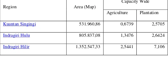
The Calculation capacity of land in each region has different characteristics for supporting and preventing variables. For areas with populations of economic resources from the agricultural sector, agricultural carrying capacity land was calculated from food production. For the physical of the individual needs 2600 calories per day, if converted into foodstuffs amounted to 265 kg of rice (Vicky RB Moniaga, 2011). Calories became the basis for the calculation is based on the needs of individuals living in the form of food calories coming from carbohydrates to food sources such as rice, corn, root, soy and nuts. Extensive cropland is a component in the calculation of the carrying capacity of agricultural land, resulting from dividing the value of the minimum physical needs with food crop production per year (tonnes) converted into calories and a kilogram of rice. Converted value will be compared with the volume of food production per kilogram of rice area / person / year. Land value will affect the condition of the area, if it is smaller then the carrying capacity of the larger farms and vice versa. The area of harvested crops derived from agricultural crop land per capita divided by the number of inhabitants per region, so the value of harvested crop to be properly harvested area is larger and vice versa.
Pelalawan 1.315.542,49 1,1278 20,0623
Siak 787.477,79 0,4546 7,2053
Kampar 1.077.260,86 0,8469 3,8563
Rokan Hulu 732.547,40 2,5946 4,2804
Bengkalis 856.902,30 0,2728 1,0796
Rokan Hilir 915.059,67 1,3493 1,6342
Meranti 366.628,12 0,0097 0,0019
Pekanbaru 62.984,20 0,0082 0,0005
Dumai 228.660,20 0,2698 0,026
The Calculation capacity of the soil conditions will be applied in the calculation of the capacity of land to produce oil palm plantations. Plantation area required to produce palm fruits (tonnes) by dividing the consumption of vegetable oil needs per region. If the value of the percentage requirement, the total demand will be used to calculate how much carrying capacity per region for the production of palm oil to be produced. Extra oil will be distributed in the form of CPO export demand and raw material combination of 5% biodiesel, and if the analysis up to 7.5% per liter of diesel fuel consumption.
Land mapping optimization results produce a new map: (i) forest area, (ii) land area, (iii) Plantation area and (iv) Agricultural Zone. Map forest area in each district provide information on the conditions of natural resources can be utilized as a particular forest area of the economy, as well as land use for the source of the data analysis in determining the development of the region per region which further grouped into ACTIVA. While maps and plantation agriculture in the balance sheet liabilities classified into PASSIVA for natural resource areas. Inter-layer technique of overlaying maps used to find the area of intersection between the boundary line identification limit land use, agriculture and plantation mapping results in the first phrase. Covering in region layer and moratorium layer on forest produce forest maps layer, land use layer region and generate maps of land use, layer farm and plantation areas produce agricultural map layer and layer maps produced agricultural regions covering all provinces conducted digitization. For the forest area per region Kuantan Singingi (4,1%), Indragiri Hulu (11,26%), Indragiri Hilir (17,58%), Pelalawan (14,13 %), Siak (7,08%), Kampar (8,37%), Rokan Hulu (3,84%), Bengkalis (13,17%), Rokan Hilir (8,77%), Meranti (8,68%), Pekanbaru (0,21%), Dumai (2,80%) from all the length of Riau Province. While the area that can be identified is about 99,32% (Source : department of Forestry, 2011). Plantation area posted in region Kuantan Singingi (0,9823%), Indragiri Hulu (1,2391%), Indragiri Hilir (3,7004%), Pelalawan (2,8354%), Siak (2,1209%), Kampar (2,8347%), Rokan Hulu (2,0604%), Bengkalis (1,0860%), Rokan Hilir (1,4834%), Meranti (0,0712%), Pekanbaru (0,0412%), Dumai (0,0858%) from the province area. While agriculture area per region Kuantan Singingi (0,7869%), Indragiri Hulu (1,3843%), Indragiri Hilir (3,4639%), Pelalawan (1,0517%), Siak (0,8334%), Kampar (2,0782%), Rokan Hulu (2,5097%), Bengkalis (0,8540%), Rokan Hilir (2,1086%), Meranti (0,2510%), Pekanbaru (0,2610%), Dumai (0,4326%)
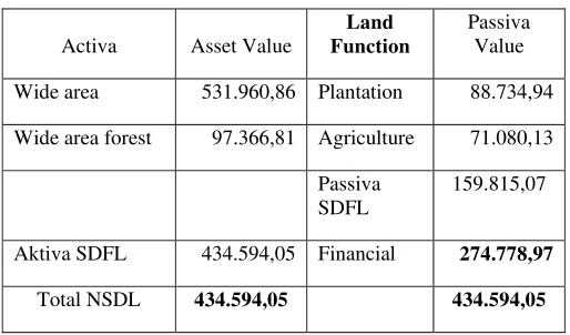
2.4 Balance Resource Land Result
Activa Asset Value
Land Function
Passiva Value
Wide area 531.960,86 Plantation 88.734,94
Wide area forest 97.366,81 Agriculture 71.080,13
Passiva SDFL
159.815,07
Aktiva SDFL 434.594,05 Financial 274.778,97
Total NSDL 434.594,05 434.594,05
Capital is a function of the total land usage that can be used and cultivated by region into plantation areas, agricultural areas and other use areas. By knowing the value of the capital development of the area intended for land use such as farming, agriculture, government, relocation area if there is a natural disaster, industrial area, terminal distribution of food and bioenergy. Capital owned vast areas per region should not exceed the value of the assets, if the condition of the capital over the state of the area is not conducive to the development of the area there, but if capital is less than the value of assets and liabilities in the stability sheet balanced and there is a backup in the form of the forest area capacity of the land in the area illustrate a very good indicator for the development of food and bioenergy.
Table 4. Agricultural Land Capability of Riau Province Region Energy & Food Security Index
Kuantan Singingi Low food Sufficient Energy
Indragiri Hulu Sufficient food Sufficient Energy
Indragiri Hilir Surplus food Surplus Energy
Pelalawan Sufficient food Surplus Energy
Siak Low food Surplus Energy
Kampar Low food Surplus Energy
Rokan Hulu Surplus food Surplus Energy
Rokan Hilir Sufficient food Sufficient Energy
Meranti Low food Low Energy
Pekanbaru Low food Low Energy
Dumai Low food Low Energy
The index of food availability will be clustered in the category of surplus food, sufficient food and low food. The categorization of food availability can be seen from agricultural land in each region so that the adequacy of food production in the supply of land can be taken in formulating the framework of food security per region. The capability of agricultural use’s value compared to plantation use’s value, this assessment value will show the condition of the food availability index categorization which determine from these three grouping. Balance of forest resources and land composition showed extensive land use for each component in both balance sheet assets and liabilities. Results of calculation in each component of the balance sheet will explain the actions decided upon in developing the potential of bioenergy and food. Extensive land into plantations is larger than the vast agricultural land or intensification of agricultural diversification process selected to maintain food security per region. If the area of agricultural function is more than the broad functions of plantation, then the agriculture production levels will have a surplus of food that food availability can be encountered independently by region.
3. RESULTS
Calculation of forest resources categorized with the national standard classification which divides Indonesia into 2 major categories namely forested and non-forested areas. Food security per region has surplus food categorization consists of Indragiri Hilir, Rokan Hulu, sufficient food consists of Indragiri Hulu, Pelalawan, Rokan Hilir, low food consists of Kuantan Singingi, Siak, Kampar, Bengkalis, Meranti, Pekanbaru, Dumai by calculation of broad functions producing bioenergy plantations and agricultural land producing specialized agricultural food production. The capacity of the soil conditions for bioenergy development in energy surplus consists of Indragiri Hilir, Pelalawan, Siak, Kampar, Rokan Hulu, sufficient energy condition consists of areas kuantan singingi, Indragiri hulu, Bengkalis, Rokan hilir and low energy conditions comprising the region Meranti, Pekanbaru and Dumai. The conditions that should be concern is the Siak and Kampar region where the condition of land capacity more than the energy capacity of the soil for agriculture. The stability of land resource resulted in a decision with hypothesis to broad indicators of land use in order to increase the value of social welfare developed patterns balanced development of bioenergy. Broad functions of large plantations specified lower agricultural production due to utilization of oil palm plantation land use excessive. Extensive agricultural land should be preserved for food production and is directed to expand agricultural land therefore the function of food per region can be seen. A reference index of food availability should regulate the development of bioenergy and food that land use in accordance with the direction of food security per region.
4. ACKNOWLEDGEMENTS
[4] Nibbi,L.,2004,“GIS METHODOLOGY AND TOOL TO ANALYSE AND OPTIMISE BIOMASS RESOURCES EXPLOITATION”, Rome
[5] Wulder, Michael A.,2008, “Spatially Explicit Large Area Biomass Estimation: Three Approaches Using Forest inventory and Remotely Sensed Imagery in a GIS”, Sensors, 8, 529-560
[6] BEFS, FAO, 2010,”Bioenergy and Food Security, The BEFS Analytical Framework”, Rome, The Bioenergy and Food Security Project, Food and Agriculture Organization of the United Nations
[7] X . ZHANG, R. C . IZAURRALDE, D. MANOWITZ, T. O. WEST, W. M. POST ,A . M. THOMSON, V. P. BANDARU, J. NICHOLS and J . R . WI L L I AMS,2010, “An integrative modeling framework to evaluate the productivity and sustainability of biofuel crop production systems”, GCB Bioenergy
[8] MICHAEL F. GOODCHILD, MAY YUAN and THOMAS J. COVA,2007,“Towards a general theory of geographic representation in GIS”, International Journal of Geographical Information Science
[9] TAMAS ABRAHAM AND JOHN F. RODDICK,1999, “Survey of Spatio-Temporal Databases”, GeoInformatica, Australia
[10] Junun Sartohadi, Ratih Fitri Putri,”Evaluasi Potensi Degradasi Lahan dengan menggunakan Analisa Kemampuan Lahan dan Tekanan Penduduk terhadap Lahan Pertanian di kecamatan KOKAP Kabupaten Kulon Progo”,Geografi, UGM, Yogyakarta
[11] Vicky R.B Moniaga, 2011,“Analisis Daya Dukung Pertanian”,ASE – Volume 7 Nomor 2 ; Mei – 2011, Hal : 68 – 68
[12] Ringgo Afrinando, 2012 ,”Perancangan Sistem Informasi Manajemen Rantai Pasok Minyak Sawit Mentah berbasis GIS”, OPTIMASI SISTEM INDUSTRI ISSN 2088-4842, 23 September 2012
[13] Roni Yunis et all, 2010,”Arsitektur Bisnis : Pemodelan Proses Bisnis Dengan Object Oriented”,Seminar nasional Informatika 2010,ISS : 1979 - 2328