EARTHQUAKE DISASTER OF YOGYAKARTA AND CENTRAL JAVA, AND DISASTER REDUCTION, INDONESIA
Sutikno
Faculty of Geography, Gadjah Mada University, Yogyakarta, Indonesia Research Centre for Disaster, Gadjah Mada University, Yogyakarta, Indonesia
E-mail: [email protected]
ABSTRACT
T
his paper discussed on earthquake disaster and its reduction of Yogyakarta and Central Java, Indonesia. The study area is located at relatively a short distance from subduction zone of India-Australian and Eurasian plates. Geologically this area is characterized by fault and graben structure, and geomorphologically is composed of block mountain, karsts topography and fluvio-volcanic plain. Aim of this paper is to evaluate the spatial distribution of the damage area, the environmental impacts, and to discuss the risk reduction of earthquake disaster scientifically and practically. In this paper to determine the hazard susceptibility zone and their environmental impact used geologic, geomorphologic, land use map, remote sensing image interpretation, and field observation. Discussion on the earthquake disaster risk reduction based on the hazard susceptibility and the characteristic of the human settlement and facilities. The result of this study shows that: i).the high damage area associate with distribution of the fault structures and the lithology; ii). mass-movement, lowering of groundwater, rising new springs, liquefaction, cracking of rocks and land surface; iii). structural non structural efforts are used for earthquake disaster reduction.Keywords: earthquake disaster, environmental impact, structural and non structural effort for reduction
INTRODUCTION
Last three years Indonesia was hit by several types of disasters, such as: earth-quake in Aceh (2004), Nias (2005), Yogya-karta, Central Java, and West Java (2006); volcanic eruption in Yogyakarta (2006); flood in Java, Kalimantan, Sumatra, Sula-wesi (2004, 2005, 2006); hot mud in East Java (2006); mass-movement (landslides) in Java, Sumatra, Sulawesi (2004, 2005, 2006). There are some geographical situa-tions that influence why Indonesia region is susceptible to many type of disasters, because the location is: in collide of three huge plate tectonics (Eurasian, India-Aus-tralian and Pacific plates), between two oceans (Pacific and Indian), and between two big continents (Australian and Asian). The effects of the collide plates, the region
Earthquake on 27th May 2006 has devastated southern part of Yogyakarta Special Region and east-southern part of Central Java Province. The Yogyakarta Special Region is a province that consists of five districts: Bantul, Yogyakarta, Sle-man, Gunungkidul and Kulon Progo. Among those districts the most damage areas are Bantul , southern part of Sleman, southern part of Yogyakarta municipality and western part of Klaten district ( it be-long to Central Java Province). Yogyakarta Special Region and Central Java Province is located in Java Island. The Java Island is a part of Indonesia territory among 17.508 islands. Most of the islands are character-ized by tectonic and volcanic activity, and humid tropic climate. That is why most part of Indonesia is prone to so many types of natural disaster, such as flood, drought, landslide, earthquake, volcanic eruption, and tsunami. The tectonic and volcanic activities in Indonesia are caused by the location in the collision of three huge plate tectonics: India-Australia, Pacific and Eurasia. The study area is located in the collision between India-Australian and Eurasian plate (Fig. 1).
When the 27th May 2006’s earth-quake occurred, it was accompanied by thundering sound, most people of Yogyakarta supposed that the thundering sound come from the Merapi volcano erup-tion ( it is located in the northern part of Yogyakarta), because at that period the Merapi volcano was erupting. Fifteen min-utes after the thundering sound, the real event was known as earthquake that epi-center is located in the southern part of Yogyakarta, precisely near by the mouth of Opak River. There was tsunami issue at that time as occurred in Aceh on 27th Decem-ber 2004, by the issue the traffic condition
of Yogyakarta and its surrounding was very crowded. People from the northern part went to the south because afraid from Merapi eruption, and reversely because afraid of tsunami; some traffic accidents occurred and it caused injury and death.ththth Earthquake disaster on 27th May 2006 with magnitude 5.9 SR (BMG) or 6.3 (USGS) caused large number of victims, houses and public facilities damage. Actually the magnitude of the earthquake is in medium scale, but it is not comparable with the number of the victims and the loss of properties. This condition invites a question and interest to discuss. There are three problems will be discussed here: i).why the study area has a high susceptibility to earthquake disaster and high vulnerability; ii). what is the environmental impact of earthquake disaster; iii). what kinds of reduction program to anticipate the probable disaster in future?
DATA AND METHOD
IKONOS bird images before and after earthquake were used to identify of land use type and to evaluate the damages. Field observation on purposive framework was carried out to determine the actual dam-ages and to estimate the environment im-pact on the physical aspect. Based on the bio-geophysical, the actual damage, the land use types data, the geographical loca-tion of the study area, and integrate to the local government program an idea to re-duce for the disaster in future is formulated.
Geolog y and Geomor pholog y of Yogyakarta and Its Surrounding
In global scale Yogyakarta and its surrounding are located on the Sunda Mountainous System, which is character-ized by non-volcanic arc and volcanic arc (Verstappen, 2001). The Sunda Mountain-ous system is extension of the Eurasian plate; it is bounded to the Indian-Austra-lian plate. The margin of the plates are in collision, resulting in the consumption of plates along subduction zone, the creation of volcanic arcs and compression of ob-lique slip structure (Darman and Hasan Sidi, 2000). The collision of the plates and the subduction zone become a concentra-tion of seismic activity and tectonic activ-ity as well (Summerfield, 1991; McGeary, et al., 2004; Abbott, 2004). Due to Yogyakarta and it surrounding are located near by the collision of the Eurasian and Indo-Australian plates, geological and geo-morphologic condition of the area is char-acterized by tectonic origin. The geologic and geomorphologic condition of the study area shortly is described below.
Based on the geological condition, the study area can be distinguished into three
parts: east, middle and western parts. Bound-ary between the middle part and eastern is Opak River, while the middle and western part bordered by Progo River. Each parts has specific in lithology, geological structure and geomorphological condition, as follow.
Geology and Geomorphology of the Eastern Part
Structurally the eastern part is block hilly to mountainous area; in the west side bordered by major Opak fault in SE direc-tion; in northern part bordered by Batuar-agung fault in EW direction. Some minor faults occur in EW-SW direction (Fig. 2). The fault pattern in eastern part associated with the spatial distribution of the damage area due the earthquake disaster. The dam-age area beside associated with the fault structure are also influenced by the lithol-ogy. The lithology of the eastern part com-posed of six unit/formations: alluvium, Wonosari, Kepek, Sambipitu, Nglanggran and Semilir formation:
1) Alluvium: composed of sand, loam and clay as weathering and erosion product from the existing rock formation; the topography is flat to gently and the land-form unit is alluvial plain and foot slope.
3) Kepek formation (Miocene): composed of marl and bedded limestone; the to-pography is undulating and the struc-ture is syncline; the landform unit is undulating syncline topography.
4) Sambipitu formation (Miocene): com-posed of tuff, shale, sandstone and con-glomerate; dip of the layer 80 locally in NE direction; topography is hilly.
5) Nglanggran formation (Miocene): com-posed of volcanic breccia, flow brec-cia, agglomerate, lava and tuff; the to-pography is hilly with steep slope, the altitude in between 200 – 500 m msl.
6) Semilir formation (Miocene): composed of interbedded tuff breccia, pumice, dacite tuff and andesite tuffs and tuf-faceous claystone; dip of layer 14-220 and the strike mainly to NE and some minor fault occur in EW and NE direc-tion ; the topography mostly is hilly, the altitude mostly less than 200 m msl. (Wartono Rahardjo et al., 1995).
Among those lithological/formation units that much were influenced by the 27th May 2006’s earthquake were alluvium, Semilir, Nglanggran, and Wonosari forma-tion. It was caused by the characteristic of the rocks properties, the geological struc-ture, the distant from the fault and the dis-tant from the epicenter of the earthquake.
Geology and Geomorphology of the Middle Part
Structurally the middle part is graben and it is called by Bantul graben. East side of the graben is bordered by Opak fault and the west side is bordered by Progo fault. Lithology of the middle part
com-posed of alluvium, young volcanic prod-uct and Sentolo for mation (Wartono Rahardjo et al., 1995). The alluvium con-sist of sand on coastal sand dune, and sand-loam of the back swamp landform unit. The back swamp formed in between natu-ral levee of Opak river in west side, hilly area in eastern side and sand dune in the southern side. The young volcanic product composed of sand to loamy sand as prod-uct of the Merapi volcano. Geomorphologi-cally the young volcanic product is located on volcanic foot plain and fluvio volcanic foot plain. The Sentolo (Miocene) forma-tion consist of limestone and marly sand-stone. Comparing with the limestone of the Wonosari formation, the karsts topography in the Sentolo formation is less develop. Relating to the 27th May 2006’s earthquake disaster the most damages area in the middle parts was on the volcanic foot plain and the fluvio-volcanic foot plain. The rea-son is the material composition of the middle parts is unconsolidated material, the groundwater at shallow depth and the area is near by the earthquake epicenter .
Geology and Geomorphology of the Western Part
sandstone., and Jonggrangan formation composed of conglomerate, tuffaceous marl and calcareous sandstone with inter-calation by lignite seams, limestone and corraline limestone. Kart topography in the Jonggrangan limestone is more well develop compare to the Sentolo limestone. The Kebobutak formation composed of andes-ite breccia, tuff, lapilli tuff, agglomerate and intercalation by lava flows. Andesite is lo-cated in the centre of West Progo Moun-tain and together with the Kebobutak for-mation supposed to be product of old vol-cano (Tertiary). The oldest formation in the western part is Nanggulan that composed of sandstone with intercalated by lignite, sandy marl, claystone with limonite con-cretion, intercalations of marl and lime-stone, sandstone and tuff.
Based on the geological and geomor-phological condition, the study area has dynamic development. It means that tec-tonic and volcanic activities has been oc-curred several time in the study area. The major fault of Opak and Progo and the as-sociated minor fault, uplifting of marine deposits such as limestone of the Wonosari, Sentolo and Jonggrangan formations must be caused by tectonic activity and accom-panied by earthquake. Naturally the study area are prone to earthquake disaster, due to the local people and the local govern-ment do not aware yet about the condition the toll by the last earthquake is too high compare to the magnitude of the earth-quake. Death from earthquakes are mostly due to building failures, and earthquake do not kill, but building do (Abbott, 2004).
Land use Type
Based on the Landsat TM and IKONOS images the land use types in the
study area can be distinguished into: rice field, dry agricultural land, settlement, for-est, plantation and bare land. Spatial dis-tribution of the land use types do not sepa-rate sharply into certain zone, but uneven distributed. The rice fields dominantly are distributed on volcanic foot plain, fluvio-volcanic foot plain and alluvial plain units of the middle part, while the dry land, plan-tation and forest are distributed on hilly-mountainous units of the eastern and west-ern part.
The settlements are distributed on various landform units, and especially on volcanic foot plain, fluvio-volcanic foot plain and alluvial plain unit. Based on the function and the facilities, the settlement can be distinguished into urban, peri-urban and rural area. In the study area that hit by the earthquake there are two main urban areas, namely Yogyakarta and Bantul. The peri-urban area is located between urban area and rural areas. Accessibility between urban, peri-urban and rural areas is good, that is why the study area has high popula-tion density. In general most part of the houses in the peri-urban and rural areas are old, simple building, one floor, without good concrete and tile roof. The such types of the houses have high vulnerability to earthquake.
RESULT AND DISCUSSION
Historical Information of Earthquake Disaster
rivers in Yogyakarta, e.g. Progo river in the west site and Opak river in the east. Most artifacts of the archaeological sites are dam-age, due to volcanic activities if are located in the volcanic area, and caused by earth-quake if are located at block faulting hilly area. Some of the artifacts were found few meters below the land surface such as Sambisari temple in Kalasan. The ruins temple of Candi Boko at Baturagung range that located along Opak fault could be caused by earthquake. The information above shows that Yogyakarta area and its surrounding several times have experiences hit by natural disasters (Sutikno, 2006).
Natural disaster in certain area usu-ally has recurrent interval, even with dif-ferent in the magnitude and intensity. As have been occurred in southern part of Yogyakarta (in Bantul) earthquake in the year of 1876 devastated 372 houses and 5 persons died; in 1943 there were 2.800 houses damaged and 213 persons died (Sutikno, 2006)
Earthquake on the 27th May 2006
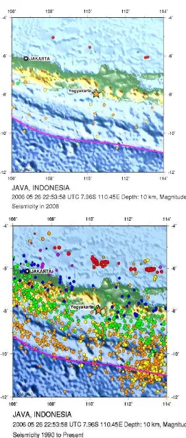
Most earthquakes are caused by fault movement associated with tectonic plates, the largest number of great earthquake oc-curred in the subduction zone of the colli-sion of tectonic plates (Abbott, 2004; McGeary et al., 2004). The case of the 27th May, 2006’s earthquake in Yogyakarta and Central Java are also caused by fault move-ment that triggered by energy from the sub-duction zone between Eurasian and Indo-Australian plates. The magnitude of the earthquake is 5.9 Richter Scale (RS) accord-ing to BMG ( Geophysical and Meteoro-logical Agency of Indonesia) and 6.3 Rich-ter Scale according to USGS (United Stated Geological Survey), the depth of the
epi-center is 33 km and located near by the mouth of the Opak river (Fig. 3), at 9.78 S and 110. 32 E (UTC).
The magnitude of the earthquake in the study area is classified as medium scale. The magnitude of earthquake usually cor-relate with the length of shaking, if the magnitude 5- 5.9 RS the duration of strong ground shaking is 2-15 seconds, and the magnitude is 6-6.9 RS the duration 10-30 seconds (Abbott, 2004).
with look like boom sound, after the sound then followed by shaking. The sound heard by people who live at the surrounding faulted area.
Based on the large number of the accompanying earthquakes after shock it means that the area is still in labile condi-tion. It is caused by the existence of the Opak fault and the accompanying faults. The faults were reactivated by the earth-quake on May 27th, 2006. Due the location of the Opak fault near by and faced to the collision of the tectonic plates and the study area above the subduction zone, the reactivated fault will occur in future. The study area still has high susceptibility to earthquake hazard and its associated im-pact.
Impact of the Earthquake of Yogya-karta and Central Java
Ground motion or land shaking by earthquakes have some kind of impacts, such as damage of building and infrastruc-tures, fire, landslide, liquefaction and
per-manent displacement of the land surface (McGeary et al., 2004), and tsunami if the epicenter is located in the ocean/floor with medium to high magnitude of the quake. The intensity impact of the earth-quake depends on several variables, such as magnitude, distance from the hypo-center/epicenter, types of rocks or sedi-ment making up the ground surface, build-ing stile, design, kind of buildbuild-ing material and height, and duration of the shaking (Abbott,2004). Regarding to the geologic and geomorphologic condition, land use type, building characteristics, the magni-tude and duration of the earthquake some impacts of the earthquake of Yogyakarta and Central Java can be identified, such as: building and houses damages, infrastruc-ture damages, liquefaction, landslide and displacement of the land surface.
Damage of Houses, Buildings, and Fa-cilities
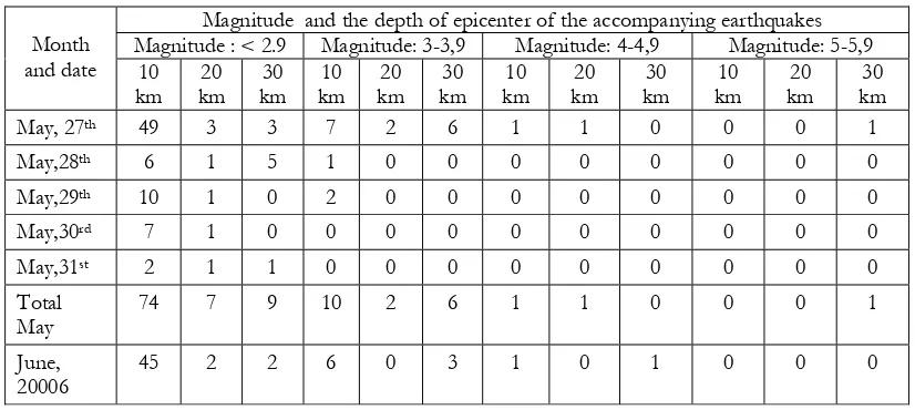
Due to the long shaking duration of the main earthquake (55 seconds) on 5.9 RS at 33 km depth, that occurred on com-Magnitude and the depth of epicenter of the accompanying earthquakes
Magnitude : < 2.9 Magnitude: 3-3,9 Magnitude: 4-4,9 Magnitude: 5-5,9 Month
Table 1. Accompanying Earthquakes after Shock of May 27th, 2006
plexes faulted area, partly composed of various rocks/sediment and dense popu-lated area may caused higher victims and damages. A large number of accompany-ing earthquakes at shallow depth also have psychological influences to the people in the stricken area. Damage assessment of any disaster in large area usually get diffi-culties, because of accessibility of the re-mote area and transport facilities. Table 2 show temporary data of the victims and Table 3 show the damages due to the earth-quake in Yogyakarta, in one week after shock. The data do not cover yet the vic-tims and the damages from Klaten district of the Central Java Province. The recent data show that the number victim 5,048 died, 206,524 houses damage, 2,014 small and medium industries damages, 2,371 school building and the financial loss for about 22 trillions rupiahs ($ 2,100 millions).
The number of victims and damage houses in Bantul are much higher compare with the others, because of the location is rela-tively close to the fault complexes, dense populated area and poor the building qual-ity. Up to now some people still live in tends, as a reason the rehabilitation and reconstruction programs of the houses do not finish yet, and they still trauma with the earthquakes occurrences. Beside the houses, some public facilities such as school building, road and water supply also damaged. Figure 4 shows spatial distribu-tion of damage areas in relating to geologi-cal condition (Murwanto et al., 2006).
Landslides due to Earthquake
Naturally the study area has medium to high landslide hazard susceptibility. It is supported by some factors, such as
geo-Table 2. Victim data of earthquake disaster of Yogyakarta ( data on June 2nd, 2006)
Number of victims
Num. District House hold Persons Death
After Sutikno, 2006
Table 3. Damage data of houses and education facilities due to earthquake disaster of Yogyakarta (data on June 2nd, 2006)
Houses damage Num. District Totally
logic, geomorphologic, climatologically and land use type condition. By shaking of the main earthquake some actual landslides occurred in the hilly-mountainous area; rock falls, landslide and slumping were identi-fied. Beside the actual, some potential land-slide also are identified, especially on the area where the land surface or the rocks surface show some fractures. The such con-dition should be take into account when the rainy come. The spatial distribution of the mass movement mainly on the steep slopes, along fault lines and along fault line scarps.
Liquefaction
Liquefaction features or sand blows, occur when ground shaking during an earthquake liquefies a subsurface layer of sand which penetrates into/or through an overlying, otherwise impenetrable layer. The overlying layer is intruded via a sand dike and if this layer is the uppermost strati-graphic unit the liquefied sand can pen-etrate to the ground surface and can be ex-pressed as mound or area of sand. The original ground surface is commonly de-pressed as a result of the displacement of the subsurface sand and water (Bryant, 2005). During the Yogyakarta’s earthquake some liquefaction features occurred, espe-cially on alluvial plain, volcanic foot plain and fluvio-volcanic foot plain units. Fea-tures of liquefaction in the study area are shown by sand blows to the land surface and sand blows through well. In certain area the sand blows can produce one truck of sand, and the sand blows trough well, the become shallower and it can not be used for domestic water supply anymore. Liq-uefaction is known to occur repeatedly at the same site during more than one earth-quake, and the maps showing locations of
past liquefaction occurrences are very use-ful to delineate and characterize areas of liquefaction susceptibility for the future earthquakes (Wakammatzu,2000).
Displacement of the Land Surface
Another features as impact of the earthquakes are displacement on the land surfaces. Displacement of the land surface can be shown by fracture or fault on the hard rocks and or on unconsolidated sedi-ment. The displacements usually have im-pact to groundwater condition, land sub-sidence and landslide. Lowering of the groundwater level up to 4 meters occur in southern part of the area, while in another sites new springs or seepage rise.
Disaster Reduction
In disaster management framework, risk reduction is important aspect. Disas-ter risk reduction is an effort to minimize the victim, property lost and environmen-tal damages. Prevention, mitigation and preparedness is component of the disaster management to reduce the victims, the property and the environment before the disaster occur. Relief, rehabilitation and reconstruction is component of the disas-ter management during and afdisas-ter the oc-currence of disaster.
Structural effort to earthquake disas-ter risk reduction is less effective than non structural, because safety of building struc-ture is depends on magnitude of the earth-quake. Building regulation is needed to ful-fill the minimum requirement for safety from a certain earthquake magnitude that usually occur in the prone area. Structural efforts for rehabilitation of the damage houses in this area used building regulation guided by local government. Rehabilitation of damage houses organized and carried out in a group of people who their houses were damage and each group was guided by a supervisor. Fi-nancial support for rehabilitation come from the government. At present the rehabilita-tion the houses do not complete yet.
Non structural effort to earthquake disaster reduction usually used possible warn-ing indicator, land use regulation, relocation of communities, public awareness and edu-cation program. Warning indicator for earth-quake, beside using seismograph record can used natural indicator. The natural indica-tor for earthquake commonly used bio-indi-cator, groundwater level changes, electric resistivity of groundwater, rock cracking and earthquake cloud. The such natural indica-tor did not take into account by the com-munity, because for along time there was no occurrence of significant earthquakes. Such as a vertical cloud feature in the southern side of the stricken area above the Indian ocean three days before earthquake was meaningless by the community. After earth-quake shaking the area people just aware that specific cloud feature as indicator for earthquake.
Land use regulation and relocation program was rather difficult to execute in this area, because the stricken areas have been occupied for along time, dense
popu-lated area and most of the people relatively poor in financial. Relating to the land use regulation, there was local wisdom in reduc-tion of earthquake. The local wisdom told orally by old generation that the younger generation should not build a house near by the river and should not used bricks mate-rial. This local wisdom was important mean-ing for risk reduction because if build the house near by the river faced with flood and earthquakes disaster, because most of the rivers in the southern part associated with fault. The faults in this area have high sus-ceptibility to earthquake hazard.
aware-ness of the community, commonly disas-ter is very vast to forget. In the earthquake disaster prone area it is important to main-tain of socialization program for risk reduc-tion, because the recurrent interval for earthquake take long time.
CONCLUSIONS
Discussing on the geologic, the geo-morphologic, the land use condition, earth-quake characteristics and its impact of Yogyakarta and Central Java disaster this paper concluded that:
1. disturbance of subduction zone of the Eurasian and the Indian-Australian plates triggered earthquake and caused reactivated of the Opak fault system then shook Yogyakarta and Central Java; geologically and geomorphologi-cally southern part of Yogyakarta and east-southern part of Central Java as prone area to earthquake hazard; the damages areas associated with the fault system;
2. the magnitude and the duration of the earthquake do not the only caused of the large number of victims and prop-erty lost but the structure and the ma-terial of building did; the duration of earthquake shaking caused the larger number of victims and property lost
more than the earthquake magnitude;
3. the main and the accompanying earth-quakes have multi-hazard impacts to the environment such as landslide, liq-uefaction, groundwater depletion and raising spring and seepages;
4. due to dense populated area and the marginal condition of the financial sup-port rather difficult to make land use regulation and relocation for risk reduc-tion from the earthquake disaster;
5. awareness and education program for the community more effective to mitigate the earthquake disaster; socialization program for risk reduction was important to maintain continually, because disaster very past to forget.
ACKNOWLEDGEMENTS
The writer gratefully acknowledges to Mr. Jaya Murjaya for supporting earth-quake data, to Mr. Helmy Murwanto, Mr. Sutarto, Mr. Tono Saptono for supporting the geological information relating to the earthquake; Mr. Danang Sri Hadmoko for preparing the English version of the geo-logical map. Last but not least thanks to Professor Haruyama Shigeko (Tokyo Uni-versity) who gave a chance to joint sympo-sium on natural disaster.
REFERENCES
Abbott,P.L. 2004. Natural Disaster. McGraw Hill. Higher Education. Boston.
BMG,2006. Characteristics of Earthquake Data of Yogyakarta Unpublished.
Bryant, E. 2005. Natural Hazards. Cambridge University Press. Cambridge.
Hardjono, I. 2006. “Hirarki Gempa Bumi dan Tsunami (Aceh, Nias, Bantul, Pangandaran, dan Selat Sunda)”. Forum Geografi, Vol. 20, No. 2, Desember 2006. Hlm 135-141.
Murwanto, H; Sutarto; Joko Susilo. 2006. Tinjauan Geologi. Dampak Gempa Tektonik terhadap Pola Rekahan dan Hancuran di Wilayah Jawa Tengah dan Daerah Istimewa Yogyakarta. Workshop. UPN. Yogyakarta.
McGeary,D. Plumer,C.C. and Carlsons, D.H. 2004. Physical Geology. Earth Revealed. McGraw Hill. Higher Education. Boston.
Sudarmadji. 2006. “Perubahan Kualitas Airtanah di Sekitar Sumber Pencemar Akibat Bencana Gempa Bumi”. Forum Geografi, Vol. 20, No. 2, Desember 2006. Hlm 99-119.
Summerfield, M.A. 1991. Global Geomorphology. Longman Scientific&Technical. New York.
Sutikno, 2006. Disaster Management and Holistic Approach in Planning for Peri-Urban Area Development. International Seminar on Regional Planning for Disaster Prone Areas in South East Asia. November 20-24-2006. Gadjah Mada University. Yogyakarta.
Verstappen, H.Th.2000. Outline of the Geomorphology of Indonesia. ITC. Enschede. The Netherlands.
Wakamatzu, K. 2000. Liquefaction History, 416-1997, in Japan. Institute of Industrial Science, University of Tokyo, Japan.
Appendix