Open Geospatial Consortium
Publication Date: 2015-11-18
Approval Date: 2015-09-17
Posted Date: 2015-07-17
Reference number of this document: OGC 15-057
Reference URL for this document: www.opengeospatial.net/doc/PER/t11-social-media-in-EM
Category: Public Engineering Report
Editors:Matthes Rieke;Simon Jirka;Stephane Fellah
OGC
®Testbed-11 Incorporating Social Media in Emergency
Response Engineering Report
Copyright © 2015 Open Geospatial Consortium
To obtain additional rights of use, visit http://www.opengeospatial.org/legal/.
Warning
This document is not an OGC Standard. This document is an OGC Public Engineering Report created as a deliverable in an OGC Interoperability Initiative and is not an official position of the OGC membership. It is distributed for review and comment. It is subject to change without notice and may not be referred to as an OGC Standard. Further, any OGC Engineering Report should not be referenced as required or mandatory technology in procurements.
Document type: OGC® Engineering Report
Document subtype: NA
Document stage: Approved for public release
Preface
This OGC Engineering Report (ER) was created as a deliverable for the OGC Testbed 11 initiative of the OGC Interoperability Program. This ER describes an approach for
incorporating Social Media for Emergency Response applications that use spatial data infrastructures. This document also reports on findings about the advancements using Social Media and VGI resources. The ER includes ideas on improving the architecture, service change recommendations (primarily concerning the OGC Sensor Observation Service (SOS) 2.0 interface), and lessons learned.
This is not a normative document.
License Agreement
Permission is hereby granted by the Open Geospatial Consortium, ("Licensor"), free of charge and subject to the terms set forth below, to any person obtaining a copy of this Intellectual Property and any associated documentation, to deal in the Intellectual Property without restriction (except as set forth below), including without limitation the rights to implement, use, copy, modify, merge, publish, distribute, and/or sublicense copies of the Intellectual Property, and to permit persons to whom the Intellectual Property is furnished to do so, provided that all copyright notices on the intellectual property are retained intact and that each person to whom the Intellectual Property is furnished agrees to the terms of this Agreement.
If you modify the Intellectual Property, all copies of the modified Intellectual Property must include, in addition to the above copyright notice, a notice that the Intellectual Property includes modifications that have not been approved or adopted by LICENSOR. THIS LICENSE IS A COPYRIGHT LICENSE ONLY, AND DOES NOT CONVEY ANY RIGHTS UNDER ANY PATENTS THAT MAY BE IN FORCE ANYWHERE IN THE WORLD.
THE INTELLECTUAL PROPERTY IS PROVIDED "AS IS", WITHOUT WARRANTY OF ANY KIND, EXPRESS OR IMPLIED, INCLUDING BUT NOT LIMITED TO THE WARRANTIES OF MERCHANTABILITY, FITNESS FOR A PARTICULAR PURPOSE, AND NONINFRINGEMENT OF THIRD PARTY RIGHTS. THE COPYRIGHT HOLDER OR HOLDERS INCLUDED IN THIS NOTICE DO NOT WARRANT THAT THE FUNCTIONS CONTAINED IN THE INTELLECTUAL PROPERTY WILL MEET YOUR REQUIREMENTS OR THAT THE OPERATION OF THE INTELLECTUAL PROPERTY WILL BE
UNINTERRUPTED OR ERROR FREE. ANY USE OF THE INTELLECTUAL PROPERTY SHALL BE MADE ENTIRELY AT THE USER’S OWN RISK. IN NO EVENT SHALL THE COPYRIGHT HOLDER OR ANY CONTRIBUTOR OF
INTELLECTUAL PROPERTY RIGHTS TO THE INTELLECTUAL PROPERTY BE LIABLE FOR ANY CLAIM, OR ANY DIRECT, SPECIAL, INDIRECT OR CONSEQUENTIAL DAMAGES, OR ANY DAMAGES WHATSOEVER RESULTING FROM ANY ALLEGED INFRINGEMENT OR ANY LOSS OF USE, DATA OR PROFITS, WHETHER IN AN ACTION OF CONTRACT, NEGLIGENCE OR UNDER ANY OTHER LEGAL THEORY, ARISING OUT OF OR IN CONNECTION WITH THE IMPLEMENTATION, USE, COMMERCIALIZATION OR PERFORMANCE OF THIS INTELLECTUAL PROPERTY. This license is effective until terminated. You may terminate it at any time by destroying the Intellectual Property together with all copies in any form. The license will also terminate if you fail to comply with any term or condition of this Agreement. Except as provided in the following sentence, no such termination of this license shall require the termination of any third party end-user sublicense to the Intellectual Property which is in force as of the date of notice of such termination. In addition, should the Intellectual Property, or the operation of the Intellectual Property, infringe, or in LICENSOR’s sole opinion be likely to infringe, any patent, copyright, trademark or other right of a third party, you agree that LICENSOR, in its sole discretion, may terminate this license without any compensation or liability to you, your licensees or any other party. You agree upon termination of any kind to destroy or cause to be destroyed the Intellectual Property together with all copies in any form, whether held by you or by any third party. Except as contained in this notice, the name of LICENSOR or of any other holder of a copyright in all or part of the Intellectual Property shall not be used in advertising or otherwise to promote the sale, use or other dealings in this Intellectual Property without prior written authorization of LICENSOR or such copyright holder. LICENSOR is and shall at all times be the sole entity that may authorize you or any third party to use certification marks, trademarks or other special designations to indicate compliance with any LICENSOR standards or specifications.
This Agreement is governed by the laws of the Commonwealth of Massachusetts. The application to this Agreement of the United Nations Convention on Contracts for the International Sale of Goods is hereby expressly excluded. In the event any provision of this Agreement shall be deemed unenforceable, void or invalid, such provision shall be modified so as to make it valid and enforceable, and as so modified the entire Agreement shall remain in full force and effect. No decision, action or inaction by LICENSOR shall be construed to be a waiver of any rights or remedies available to it.
Contents
Page1 Introduction ... 1
1.1 Abstract ... 1
1.2 Business Value ... 1
1.3 Keywords ... 2
1.4 Document contributor contact points ... 2
1.5 Future work ... 2
5 Testbed-11 Incorporating Social Media in Emergency Response Engineering Report ... 6
5.2.3.2 Open Street Map (OSM) ... 11
5.2.3.3 Storyful ... 11
5.3 SOS for Social Media ... 14
5.3.1 Mapping of Social Media entries to O&M 2.0 ... 15
5.3.2 Examples ... 16
5.3.2.1 Example Request - GetObservation ... 16
5.3.2.2 Example Response - GetObservation ... 16
5.4 Integrating Social Media Data using SOS ... 19
5.4.2 API connectors ... 20
5.4.3 SOS 2.0 Transactional Interface ... 22
5.4.3.1 InsertSensor ... 22
5.4.3.2 InsertObservation ... 24
5.5 WPS for Social Media ... 27
5.5.1 Cluster Algorithm ... 27
5.5.2 Operations and Requests ... 27
5.6 Social Media Client ... 29
5.6.1 Workflow ... 31
5.7 Social Media Integration using Linked Data and REST ... 32
5.7.1 Overview ... 32
5.7.2 Semantic Social Media Scraper Service ... 33
5.7.2.1 Overview ... 33
5.7.2.2 REST API ... 34
5.7.2.3 LD Scraper Type Resources ... 35
6 Accomplishments ... 51
7 Lessons Learned ... 52
8 Recommendations and Future Work ... 54
9 References ... 56
A.1 SocialML Microtheories Overview ... 57
A.3.1 Social Items Microtheories ... 60
A.3.2. Social Activity Microtheories ... 65
A.3.2.1 Core Social Activity Microtheory ... 65
A.3.2.2 Social Web Activities Microtheory ... 67
A.3.3 Social Group Microtheories ... 67
A.3.3.1 The Group Microtheory ... 67
A.3.3.2. The Organization Ontology ... 68
A.3.2.4. Person Microtheories ... 70
A.3.2.4.1 Personal Identification ... 70
A.3.2.4.2 Physical Characteristics ... 71
A.3.2.4.3 Cognitive Characteristics ... 73
A.3.2.5 Social Relationships Microtheories ... 73
A.3.2.5.1 Core Relation Microtheory ... 74
A.3.2.5.2 Interpersonal Relationships ... 76
A.3.2.5.2 Inter-organizational Relationships Ontology ... 76
Figures
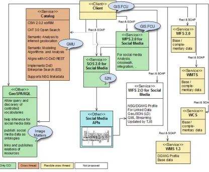
PageFigure 1 - CCI Architecture ... 7
Figure 2 - Architecture of the 52°North SOS ... 14
Figure 3 - Example Flickr Observation ... 16
Figure 4 - Harvester API class diagram ... 19
Figure 5 - DBSCAN illustration ... 27
Figure 6 - Display of all Social Media content ... 29
Figure 7 - Result of the DBSCAN Clustering ... 30
Figure 8 - Sequence diagram of the Social Media process ... 31
Figure 9 - Functional Architecture of the Semantic Media Scrapper Service ... 34
Figure 10 - SIOC Model ... 60
Figure 11 - Overview of Item class hierarchy ... 62
Figure 12 - Overview of Container class hierarchy ... 62
Figure 13 - Activity Model ... 66
Figure 14 - Organization Ontology ... 69
Figure 15 - Personal Identifier class hierarchy ... 71
Figure 16 - Physical Characteristics Class Hierarchy ... 72
Figure 17 - Cognitive Characteristics ... 73
Figure 18 - Relationship Model ... 75
Tables
PageTable 1 - Assessment of Instagram ... 9
Table 2 - Assessment of Flickr ... 9
Table 3 - Assessment of Twitter ... 10
Table 4 - Assessment of Picasa ... 11
Table 5 - Assessment of Storyful ... 11
Table 6 - Assessment of Panoramio ... 12
Table 7 - Assessment of Yotube ... 12
Table 8 - Overview of the REST API of the Semantic Media Scrapper Service ... 35
Table 9 - MIME Types Supported by the Semantic Media Scrapper Service ... 35
Table 10 - Properties of Scraper Types ... 37
Listings
PageListing 1 - Example Flickr Observation ... 17
Listing 2 - InsertSensor Example ... 22
Listing 3 - InsertObservation Example ... 24
Listing 4 - Example of a WPS StatusInfo response ... 28
Listing 5 - Example of a Response in the Turtle Format ... 36
Listing 6 - Twitter Scraper Type Description ... 40
Listing 7 - Example Response of a Twitter Scraping Process ... 44
Listing 8 - Example Response of a Flickr Scraping Process ... 47
OGC
®Testbed-11 Incorporating Social Media in Emergency
Response Engineering Report
1 Introduction
1.1 Abstract
This OGC® Engineering Report (ER) describes approaches to incorporating Social Media as a data source for Emergency Response. The work described in the ER was performed as part of the Testbed-11 Cross-Community Interoperability service architecture. This ER provides an overview of the data sources for Social Media, discussing discovery aspects as well as quality assessment approaches.
Two approaches were implemented during Testbed-11. The first was based on the concept of using an OGC Sensor Observation Service (SOS) for handling humans as sensors and considered especially from an interoperability perspective. A mapping into the OGC/ISO Observations and Measurements (O&M) data model is presented and illustrated with examples from different social media platforms. This is complemented by a description of how data loading from social media platforms into an SOS server can be achieved. The second approach is based on using Linked Data to integrate content as social “objects” produced by the different social media sites. The ontology for describing social objects and activities is based on the SocialML ontology1 and can be extended to
accommodate new activities and social objects. The integration of social site content was accomplished with RDF scrapers accessible through a REST API. The merged
knowledgebase can be accessed through a GeoSPARQL endpoint.
Another important topic of this report is the use of the OGC Web Processing Service (WPS) for analyzing the available social media data (i.e. detect clusters). Finally, a client for accessing the provided data sources and processes is introduced.
1.2 Business Value
The findings described in this ER will help to integrate social media content into standards-based geospatial information infrastructures and systems. This way, a new source of, often up-to-date, information will be made available. Especially in application contexts such as emergency response this will open up new opportunities to achieve better situational awareness. As a result, not only the capabilities of emergency responders will be improved but also the value of social media content will grow.
1.3 Keywords
Ogcdoc, ogc documents, testbed 11, t11, ogc, cci, social media
1.4 Document contributor contact points
All questions regarding this document should be directed to the editor or the contributors:
Name Organization
Matthes Rieke (MRI) 52°North, m.rieke<at>52north.org
Simon Jirka (SJI) 52°North, s.jirka<at>52north.org
振宇 How GIS.FCU, how<at>gis.tw
Stephane Fellah (STF) Image Matters,
stephanef<at>imagemattersllc.com
1.5 Future work
For recommendations on future work please refer to section 8.
1.6 Foreword
Attention is drawn to the possibility that some of the elements of this document may be the subject of patent rights. The Open Geospatial Consortium shall not be held
responsible for identifying any or all such patent rights.
2 References
The following documents are referenced in this document. For dated references, subsequent amendments to, or revisions of, any of these publications do not apply. For undated references, the latest edition of the normative document referred to applies. OGC 06-121r3, OWS Common Implementation Standard
OGC 10-004r3, OGC Abstract Specification, Geographic information - Observations and Measurements
OGC 10-025r1, Observations and Measurements - XML Implementation OGC 12-006, OGC Sensor Observation Service Interface Standard OGC 14-016, OGC Testbed-10 CCI VGI Engineering Report OGC 14-065, OGC WPS 2.0 Interface Standard
SIOC, http://www.w3.org/Submission/sioc-spec/
W3C Resource Description Framework (RDF), http://www.w3.org/RDF/ W3C Web Ontology Language (OWL), http://www.w3.org/2001/sw/wiki/OWL
3 Terms and definitions
4 Conventions
4.1 Abbreviated terms
API Application Programming Interface COI Community of Interests
CRUD Create, Read, Update and Delete FOAF Friend of a Friend
JSON JavaScript Object Notation JSON-LD JSON for Linking Data LDP Linked Data Platform
MOC Minimal Ontological Commitment O&M Observations & Measurements OGC Open Geospatial Consortium OWL Web Ontology Language
RDF Resource Description Framework
SIOC Semantically-Interlinked Online Communities SKOS Simple Knowledge Organization System SNA Social Network Analysis
SOS Sensor Observation Service Testbed-11 OGC Testbed, Phase 11 URL Uniform Resource Locator
VGI Volunteered Geographic Information W3C World Wide Web Consortium WFS Web Feature Service
WPS Web Processing Service XML Extensible Markup Language
4.2 UML notation
5 Testbed-11 Incorporating Social Media in Emergency Response Engineering Report
One task in the Testbed-11 CCI Thread was to study different approaches to
incorporating social media information into Emergency Response applications. Two approaches were tested during the Testbed-11. The first one was based on the concept of using an OGC Sensor Observation Service (SOS) for handling humans as sensors is illustrated from an interoperability perspective. The developed O&M-based data model is presented and illustrated with examples from different social media platforms. This is complemented by a description of how data loading from social media platforms into an SOS server can be achieved. The second approach was based on using Linked Data to integrate social objects produced by the different social media networks. The ontology for describing social objects and activities is based on SocialML ontologies that can be extended to accommodate new activities and social objects. The integration of social sites was done through the use of RDF scrapers accessible through a REST API. The resulting knowledgebase was made available through a GeoSPARQL endpoint. Another important topic of this report is the use of the OGC Web Processing Service (WPS) for analyzing the available social media data (i.e. detect clusters). Finally, a client for accessing the provided data sources and processes is introduced.
5.1 CCI Architecture
The Testbed-11 Cross Community Interoperability (CCI) thread is organized into several different tracks following separate approaches that use various technology stacks. The different tracks are:
Linked Data & Semantic Enablement of OGC Services Symbology & Semantic Mediation
Aviation
Use of Semantic Linked Data with RDF for National Map NHD and Gazetteer Data
Social Media & Semantic Mediation
For information on the CCI tracks not covered in this document, consider the following Testbed-11 Engineering Reports:
OGC 15-054: Implementing Linked Data and Semantically Enabling OGC Services
OGC 15-055: Catalogue Service Analysis and Recommendations
OGC 15-066: Use of Semantic Linked Data with RDF for National Map NHD and Gazetteer Data
OGC 15-058: Symbology Mediation Engineering Report
2014). Figure 1 illustrates the overall architecture. The architecture involves client, server and processing/middleware components. Section 5 introduces the developed components in more detail.
5.2 Social Media Resources
The data to support the use case was harvested from well-established Social Media platforms. In order to identify valuable platforms that fit into the use case (e.g. geo-tagged data, high usage rate) candidate platforms were analyzed and assessed for their ability to best serve the use case.
This section provides an overview on the Social Media platforms that have been
evaluated against the requirements for the Emergency Response scenario. The evaluation is separated into three categories – supported, promising and unsuitable platforms. A decision sheet is documented for every platform, providing formal parameters for assessing the suitability.
5.2.1 Search Criteria
To support the use case of identifying possible evacuation routes for a flood event, a pre-defined search on all supported platforms was used to gather the data. The search criteria included a time window (2014-12-10 until 2014-12-12) and a geographic area (San Francisco center with radius of five miles around the center). No content-wise filtering (e.g. tags or textual content) was applied in the data harvesting process.
5.2.2 Supported Platforms
The platforms presented within this section are assessed as well-suited for Emergency Response applications. Besides the good suitability, open source implementations on gathering its data have been developed within the scope of Testbed-11.
The following criteria were used to identify suitable candidates of data for use in Emergency Response:
Public Search API available Support for filter by geolocation Support for filter by time and date Support for filter by keywords/tags
Besides these hard criteria, additional soft criteria have been applied: Amount of overall postings for the desired time and location Number of postings with geotags
Provision of pictures
5.2.2.1 Instagram
Instagram was assessed to be a suitable candidate due to its features:
Table 1 - Assessment of Instagram
Criterion Availability Comment
Public search API Available Filter by geolocation Available Filter by time and date Available Filter by keywords/tags Available
Number of postings Ca. 150 for the defined search criteria
Number of postings with geo information
Not measurable, no official information available Pictures supported Yes
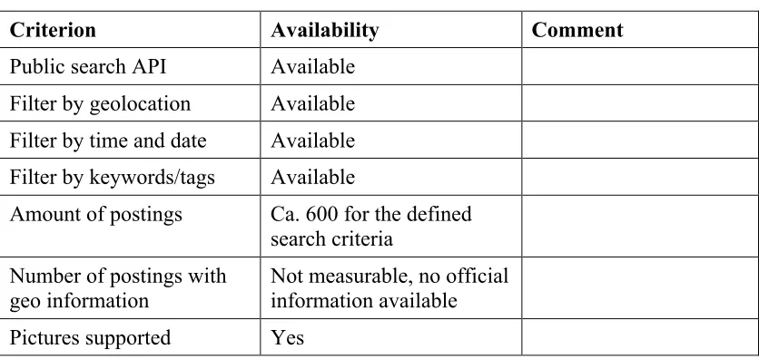
5.2.2.2 Flickr
Similar to Twitter the usage of Flickr as a data source for Volunteered Geographic Information (VGI) was evaluated and tested in OGC Testbed-10 (see OGC 14-016). Flickr is the biggest photo community on the web and also provides asocial media features.
Flickr was assessed as a suitable candidate due to its features:
Table 2 - Assessment of Flickr
Criterion Availability Comment
Public search API Available Filter by geolocation Available Filter by time and date Available Filter by keywords/tags Available
Amount of postings Ca. 600 for the defined search criteria
Number of postings with geo information
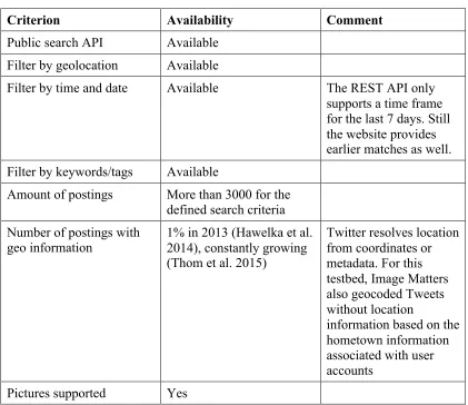
5.2.2.3 Twitter
Twitter is currently one of the largest Social Media networks with more than 300 million active users. The integration of Tweets into an OGC service architecture was prototyped within the OGC Testbed-10.
Twitter was assessed as a suitable candidate due to its features:
Table 3 - Assessment of Twitter
Criterion Availability Comment
Public search API Available Filter by geolocation Available
Filter by time and date Available The REST API only supports a time frame for the last 7 days. Still the website provides earlier matches as well. Filter by keywords/tags Available
Amount of postings More than 3000 for the defined search criteria
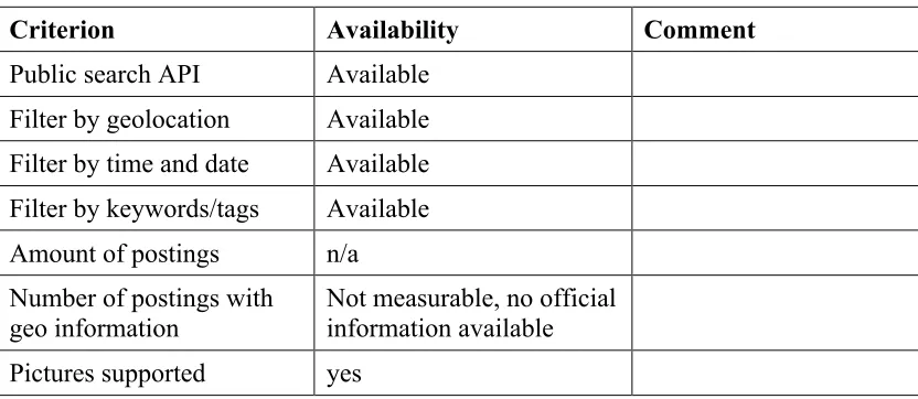
5.2.3.1 Picasa
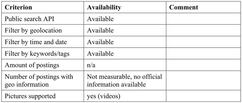
Picasa was assessed as a promising candidate due to its features:
Table 4 - Assessment of Picasa
Criterion Availability Comment
Public search API Available Filter by geolocation Available Filter by time and date Available Filter by keywords/tags Available Amount of postings n/a Number of postings with
geo information
Not measurable, no official information available Pictures supported yes
5.2.3.2 Open Street Map (OSM)
Open Street Map is a special candidate among the assessed platforms. OSM does not offer a public API comparable the other Social Media platforms. Still it provides up-to-date infrastructure data based on volunteered geographic information. Therefore OSM is a good candidate for inclusion into the overall scenario but should be treated differently (e.g. as a basis for identifying escape routes).
5.2.3.3 Storyful
Storyful was assessed as a promising candidate due to its features:
Table 5 - Assessment of Storyful
Criterion Availability Comment
Public search API Available Filter by geolocation Available Filter by time and date Available Filter by keywords/tags Available Amount of postings n/a Number of postings with
geo information
5.2.3.4 Panoramio
Panoramio was assessed as a promising candidate due to its features:
Table 6 - Assessment of Panoramio
Criterion Availability Comment
Public search API Available Filter by geolocation Available Filter by time and date Available Filter by keywords/tags Available Amount of postings n/a Number of postings with
geo information
Not measurable, no official information available Pictures supported yes
5.2.3.5 YouTube
Though the number of YouTube videos featuring geolocation and near real time footage is increasing, the data supporting the defined scenario was very small. The integration was tested and performed prototypically within the Linked Data components described in section 5.7. In the future and also for other scenarios the amount of relevant data might grow. Thus the platform was assessed as promising.
Table 7 - Assessment of Yotube
Criterion Availability Comment
Public search API Available Filter by geolocation Available Filter by time and date Available Filter by keywords/tags Available Amount of postings n/a Number of postings with
geo information
5.2.4 Unsuitable Platforms
The following platforms did not meet the requirements for providing public data useful for Emergency Response scenarios.
5.2.4.1 Facebook
Though Facebook is the biggest Social Media network in the Web, it does not meet the requirements for an Emergency Response scenario as it closed its public search API in April 2014.
5.2.4.2 Tumblr
Tumblr is a personal blogging system with community aspects. Still it does not meet the specified requirements as no global search API is available. A search is limited to a single user blog instance only.
5.2.4.3 Pinterest
Similar to Tumblr, Pinterest does not provide a global search but only a limited discovery to specific user domains.
5.2.4.4 Snapchat
5.3 SOS for Social Media
The first approach investigated for incorporating social media with emergency response applications leveraged the existing Sensor Observation Service (SOS), by modeling social media information as Observations, extending the role of human as sensor.
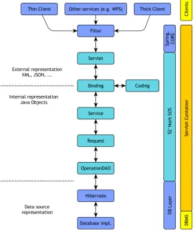
The SOS for Social Media was set-up based on the 52°North SOS 4.x development line2.
This SOS server is implemented in Java relying on several standard technologies and libraries. The architecture of the 52°North SOS server 4.x is summarized in Figure 2.
Figure 2 - Architecture of the 52°North SOS
The 52°North SOS server can be flexibly coupled to a broad range of data sources (e.g. many commonly used relational database management systems) and data models. For the OGC Testbed-11 the default database model of the 52°North SOS server was used within a PostgreSQL database. As this data model was designed based on the concepts provided by the O&M 2.0 standard, no further changes to the internal data model of the 52°North
SOS were necessary. This approach relies on the findings described in the OGC® Testbed-10 CCI VGI Engineering Report.
The SOS for Social Media supports the following operations specified by the SOS 2.0 standard:
GetCapabilities: Retrieving metadata about the SOS server DescribeSensor: Retrieving metadata about the observers GetObservation: Retrieving social media observations/content
In addition, the SOS for Social Media offers the following transactional SOS operations to publish previously harvested social media observations:
InsertSensor: Registration of new observers
InsertObservation: Inserting new social media content published by a previously registered observer
Furthermore, to facilitate the integration with legacy software that does not yet support the SOS 2.0 standard, the WFS 2.0 GetFeature operation was also implemented. Thus, the SOS for social media allows interoperable publication and retrieval of social media observations. As the next subsection will show, the O&M 2.0 data model is already well suited for modelling and encoding social media observations. No significant changes to the SOS implementation were needed to handle social media content. The main challenges were on the harvesting and data loading mechanisms described in section 5.4.
5.3.1 Mapping of Social Media entries to O&M 2.0
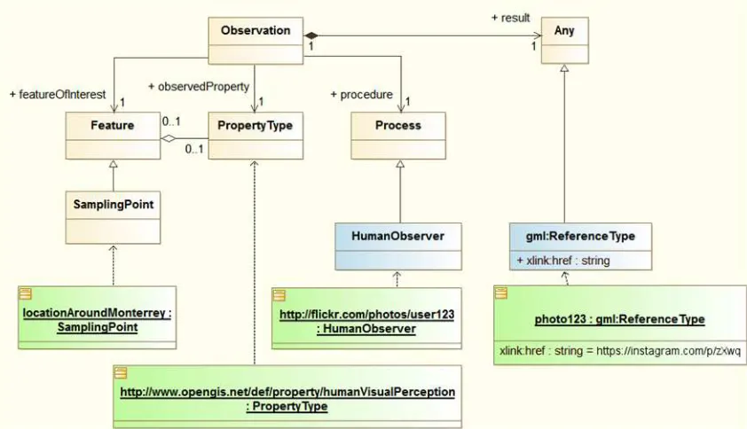
The mapping of social media content to the O&M 2.0 model can be achieved in a straightforward manner. This is based on the idea that basically all social media content relevant for the scenario (e.g. photos, messages describing certain situations) can be considered as observations made by humans. This leads to the following mapping between typical social media content (see Figure 3 for an example based on Flickr) and the O&M 2.0 model:
Feature of Interest: The location/object/place for which the observer has published an observation
Observed Property: The property which is described by the observation (e.g. in case of a photo this would be the visual perception)
Figure 3 - Example Flickr Observation
5.3.2 Examples
The two following subsections show an example for a GetObservation request as well as a response.
5.3.2.1 Example Request - GetObservation
The following URL shows an exemplary GetObservation request (KVP binding) to retrieve content from the SOS for Social Media:
http://ows.dev.52north.org:8080/52n-wfs-webapp/sos/kvp ?service=SOS
&version=2.0.0
&request=GetObservation
&observedProperty=http://www.opengis.net/def/property/ humanVisualPerception
&temporalFilter=om:phenomenonTime,2014-12-11T10:00:00.000Z/ 2014-12-11T15:00:00.000Z
In this case, all human observations made between 10:00 and 15:00 on the 11th December 2014 are requested.
5.3.2.2 Example Response - GetObservation
The photo was taken on December 11th 2014 at 07:40:30. It was published at 21:17:43 on the same day.
The photo was taken in San Francisco.
The result points to the URL on Flickr where the photo can be accessed.
Listing 1 - Example Flickr Observation
<sos:observationData>
<om:OM_Observation gml:id="o_346FA74773F61F3B190E724CBAC067F985C62"> <gml:identifier codeSpace="http://www.opengis.net/def/nil/OGC/0/ unknown">
https://www.flickr.com/photos/username/123456789/ </gml:identifier>
<om:type xlink:href="http://www.opengis.net/def/observationType/ OGC-OM/2.0/OM_TextObservation"/>
<om:phenomenonTime>
<gml:TimeInstant gml:id="phenomenonTime_5515"> <gml:timePosition>
<gml:TimeInstant gml:id="ti_46E6CA6A401C83E0612146D2D54CF02A"> <gml:timePosition>
2014-12-11T21:17:43.000Z </gml:timePosition>
</gml:TimeInstant> </om:resultTime>
<om:procedure xlink:href="https://www.flickr.com/photos/ 123456789@N00"/>
<om:observedProperty xlink:href="http://www.opengis.net/def/ property/
humanVisualPerception"/> <om:featureOfInterest>
<gml:pos srsName="http://www.opengis.net/def/crs/ EPSG/0/4326">
-122.3926 37.7927 </gml:pos>
</gml:Point> </sams:shape>
</sams:SF_SpatialSamplingFeature> </om:featureOfInterest>
<om:result xmlns:xs="http://www.w3.org/2001/XMLSchema" xsi:type="xs:string">
https://www.flickr.com/photos/username/123456789/ </om:result>
5.4 Integrating Social Media Data using SOS
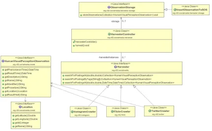
In order to smoothly integrate different social media platforms, 52°North developed a Java API for Social Media Harvesting3. This section illustrates the architecture, concepts
and workflows of this API.
5.4.1 Class Architecture
Figure 4 shows the high level class structure of the API. The central component is the HarvesterController. It manages the available implementations of the Harvester interface. The HarvesterController can be configured with several search criteria (see Section 5.2.1) and provides one single harvest method for starting the overall harvesting process.
The Harvester interface is the entrance point for the access to the different Social Media APIs. It provides high level methods for dataset discovery (searchForPostingssAt()).
Figure 4 - Harvester API class diagram
All Harvester implementations shall provide a collection of HumanVisualPerception-Observation instances back to the HarvesterController after finishing the search. This interface provides abstract methods to data concepts that are shared among social media APIs (e.g. user, tags, location and time) as well as methods for accessing the actual content of a posting (e.g. image captions, post contents). The
Observation interface is aligned with the O&M 2.0 Social Media model (see section 5.3.1) and provides corresponding method names.
After the harvest process has finished, the HarvesterController can upload the data to an SOS 2.0 server through the transactional interface via the InsertObservationToSOS class. Still, the ObservationStorage interface provides means to extend the architecture with a complementary storage mechanism.
5.4.2 API connectors
The developed API connectors all implement the aforementioned Harvester interface. All supported Social Media APIs have been accessed via a RESTful interfaces providing JSON encoded data. For accessing Twitter a dedicated Java library4 was used.
Instagram and Flickr were accessed by straight-forward URL calls. An exemplary location-based search on Instagram looks like the following:
https://api.instagram.com/v1/media/search?lat=37.7611895&lng=-122.3821116&min_timestamp=1449705600&max_timestamp=1449878400&access_tok en=
"likes":{
5.4.3 SOS 2.0 Transactional Interface
For inserting the gathered data into the SOS 2.0 for Social Media the transactional interface of the SOS 2.0 interface standard was used. This way the implementation of harvesting and the storage is connected via interoperable and well-established methods. This section provides a brief overview on the required interface interactions.
5.4.3.1 InsertSensor
Prior to the insertion of actual observations knowledge of the procedure to the SOS service needs to be provided. The user who posted the social media entry has been mapped to the procedure in the Social Media model (see section 5.3.1). The following request illustrates an exemplary InsertSensor request for providing these metadata.
<sml:OutputList>
http://www.opengis.net/def/property/humanVisualPerception </swes:observableProperty>
In the case of Social Media the offering was defined as the overall Social Media platform (e.g. Twitter, Instagram or Flickr).
5.4.3.2 InsertObservation
Once the offering and procedure are registered at the SOS 2.0, the actual observations can be inserted. This has been achieved via the InsertObservation method. The
following request provides an exemplar template for inserting an observation.
Listing 3 - InsertObservation Example
<?xml version="1.0" encoding="UTF-8"?>
<env:Body>
<sf:type xlink:href="http://www.opengis.net/def /samplingFeatureType/OGC- OM/2.0/SF_SamplingPoint"/> <sf:sampledFeature xlink:href="http://www.52north. org/sos/featureOfInterest/ world/us/ca/san_francisco"/> <sams:shape>
<gml:Point gml:id="foiPointID"> <gml:pos
srsName="http://www.opengis.net/def/crs/ EPSG/0/4326">${lonLat}
</gml:pos> </gml:Point> </sams:shape>
</sams:SF_SpatialSamplingFeature> </om:featureOfInterest>
<om:result xsi:type="gml:ReferenceType" xlink:href="${resultHref}"/> </om:OM_Observation>
</sos:observation> </sos:InsertObservation> </env:Body>
</env:Envelope>
5.5 WPS for Social Media
GIS.FCU implemented a WPS 2.0 instance based on GeoServer5. GeoServer is a Java
based GIS web server. Applications can publish geospatial data easily by the functions and GUI built in GeoServer. The latest version of GeoServer is 2.7.1 and it supports various OGC standards, including WFS, WCS, WMS, WMTS, TMS and WPS. An algorithm for spatially clustering Social Media contents has been implemented. The operations GetStatus, GetResult and Dismiss were implemented in the latest version of the GeoServer WPS that supports the WPS 2.0 standard as well as a RESTful binding.
5.5.1 Cluster Algorithm
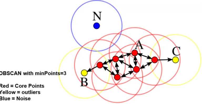
The DBSCAN (Density-Based Spatial Clustering of Applications with Noise) algorithm was chosen for the spatial clustering of Social Media contents provided by the data sources (SOS and GeoSPARQL endpoint). DBSCAN groups together points that are close to each other (see Figure 5). The resulting clusters are provided as a result set of the WPS process.
Figure 5 - DBSCAN illustration
5.5.2 Operations and Requests
Besides GetCapabilities and DescribeProcess, the Execute operation is the main entrance point for the algorithm. The identifier for the developed DBSCAN algorithm is
“gs:SocialMedia”.
“gs:SocialMedia” provides three parameters to calculate clustered social media data. 1. Keyword: filter parameter to extract data regarding a specific issue (e.g. “storm”) 2. Distance: the distance of radius for each social media data element to calculate
the number of neighbors
3. Neighbors: the fulfilling condition if the number of social media data within specific radius distance exceeds neighbors
The Execute operation has three patterns based on different requirements:
Get all social media data from SOS by sending request with null parameters. Get clustered social media data from SOS by sending request with distance,
neighbors parameters.
Get clustered social media data regards to specific issue from SOS by sending request with all parameters.
The result is retrieved asynchronously via the GetResult operation. An exemplary result is illustrated in Listing 4.
Listing 4 - Example of a WPS StatusInfo response
<?xml version="1.0" encoding="UTF-8"?>
<wps:StatusInfo xmlns:ows="http://www.opengis.net/ows/2.0" xmlns:wps="http://www.opengis.net/wps/2.0.0"
xmlns:xsi="http://www.w3.org/2001/XMLSchema-instance" xsi:schemaLocation="http://www.opengis.net/wps/2.0.0 http://schemas.opengis.net/wps/ 2.0.0/wpsAll.xsd">
<wps:JobID>082be5b5-44aa-4e22-8a70-0f779c651d2d</wps:JobID> <wps:Status>Succeeded</wps:Status>
<cluster id="-1"/> <cluster id="0"/> <cluster id="1"> <sensor id="1">
<lat>37.771007</lat> <lng>-122.412694</lng>
<title>Major Storm in San Francisco!!</title> </sensor>
5.6 Social Media Client
The Social Media Client developed by GIS.FCU interacts with the 52°North SOS for Social Media and the Image Matters GeoSPARQL endpoint as well as the WPS for clustering. It supports the retrieval of all collected Social Media content (see Figure 6).
The execution of the WPS process is done by providing the required parameters via the user interface on top of the map. Figure 7 shows the clustered results of the WPS process.
5.6.1 Workflow
Figure 8 illustrates the workflow and interactions with other components. The WPS process retrieves the relevant observations from the SOS 2.0 for Social Media and applies the clustering subsequently. While the calculation is ongoing, the client can retrieve the status of the process job as well as the result once it has finished.
5.7 Social Media Integration using Linked Data and REST 5.7.1 Overview
Social Media Sources and in particular Volunteered Geographic Information (VGI) has emerged as an important source of up-to-date geo-social information for supporting Emergency Response operations, providing relevant social information (pictures, tweets, narrative, discussion, etc) connected with specific locations and events.
To facilitate the integration of crowd-sourced geosocial information with existing features, POI and gazetteer data used in Emergency Response, Image Matters (IM) implemented a semantic mapping of information from social media sources to the core geospatial ontologies developed by IM during OWS-10. Content such as Tweets, Videos, Articles, Social Events, etc. were mapped as Social Objects to the cross-domain social media ontology SocialML. This ontology, composed of a number of microtheories, has been developed and tested by Image Matters over the last 4 years (partially funded by DARPA) and has been provided as in-kind contribution to this project. The microtheories have been documented in Annex A and the ontology documentation has been published online at the following endpoint: http://ows.usersmarts.com/socialml.
SocialML is an extensible ontological foundation for representing content produced by social media users. It provides a unifying framework that can interoperate with present as well as new and emerging social networks. It is intended to consolidate many existing models (SIOC, Schema.org, Activity Streams) into a single coherent semantic
framework. Before SocialML, Social Web sites remained largely isolated silos with their own APIs and data representations (e.g., Google OpenSocial, Facebook Open Graph,Twitter, YouTube, …), generally based upon syntactic and structural
representations (mainly JSON and XML) that are poor in semantics, making interoperability between social networks difficult.
To demonstrate the use of SocialML, Image Matters leveraged its semantic middleware platform KnowledgeSmartsTM to scrape social media sources into linked data
representations based on the SocialML ontologies and the search criteria supported by targeted social media services. This information was then made available using a REST API that can be queried and integrated with other linked data sources used for Emergency Response. The initial focus was on the use of geospatially-enabled social media services such as Twitter and Flickr feeds. The goal of this approach was to demonstrate the ease of integration of different social media sources using linked data technologies and to provide a unified and simpler access API using a REST API for linked data (LD) scraper services and the use of the GEOSPARQL query language on the aggregation of of social content as linked data. This approach represents a significant alternative to representing all social media content as human sensor observations in a Sensor Observation Service (SOS) or WPS. The service could be easily integrated by a third party as a WPS service using a WPS REST API wrapper. The use of linked data standards can simplify
5.7.2 Semantic Social Media Scraper Service 5.7.2.1 Overview
With the large variety of social media APIs providing heterogeneous access to content, it is difficult to integrate information into a coherent framework that supports analysis and leads to informed decisions. Using a common core vocabulary to describe social concepts and activities, we can extend and accommodate the specificities of each API without breaking the coherency of the representation of the social information generated by these sites. The linked data representation of social information using standards such as RDF, OWL, SPARQL and OGC GeoSPARQL provides a consistent, unified representation and means of access. The use of ontologies also enables powerful reasoning capabilities that can relieve some of the cognitive burden on first responders trying to use social media as actionable information for decision support.
The integration of social media content is performed in three layers:
Figure 9 - Functional Architecture of the Semantic Media Scrapper Service
5.7.2.2 REST API
The REST API is summarized in the following table.
Table 8 - Overview of the REST API of the Semantic Media Scrapper Service
Method Endpoint Description Response Format
GET /types Get the list of the RDF
scraper available
TTL,N3,RDF,JSON-LD
GET /types/{name} Get the description of the RDF scraper with the given name with its supported parameter
TTL,N3,RDF,JSON-LD
GET /types/{name}/scrape Invoke the scraping operation associated with the scraper of the given name6
TTL,N3,RDF,JSON-LD
The following MIME types are supported by the REST API and file extensions in URL are supported to make it easy to test manually from a browser (machine should use MIME type negotiation).
Table 9 - MIME Types Supported by the Semantic Media Scrapper Service
MIME Extension Description
text/turtle .ttl Turtle format
text/n3 .n3 N3 Format
application/rdf+xml .rdf RDF/XML format
application/n-triples .nt N-Triples format application/ld+json .jsonld JSON-LD format
5.7.2.3 LD Scraper Type Resources
An RDF Scraper Type is a web accessible process accessing a data source (through API call or data document) and produces a linked data representation of the information retrieved from the source. The LD Scraper service uses a pluggable architecture to add new LD Scraper Types (such as Instagram, Vimeo, ISO 19139 documents, etc.). The plugins can be discovered dynamically and the offerings can be accessed through the RESTful API.
5.7.2.3.1 Get the List of available LD scrapers
To get the list of RDF scraper type offerings from the service, the service provides an endpoint that returns a collection of ScraperType instances according the Linked Data Platform API specification.
Request
Endpoint: /types Method: HTTP Get
The request accepts the following mime types: TTL, N3, RDF/XML, NT and JSON-LD.
Response
Note that this endpoint implements the Linked Data Platform API (using
ldp:BasicContainer to represent collection in RDF) and the following HTTP header (as standardized in the Linked Data Platform specification7).
The following is an example of a response in the Turtle format8. The response returns a
BasicContainer which refers to the different ScraperType supported by the service (using the standard property ldp:contains). The document contains a brief description of each scraper type by providing a title, a description (rdfs:comment) and a unique name that is used in the REST API to get more details about the resource. Note that the uri of each scraper type are resolvable as required by the LDP specification.
Listing 5 - Example of a Response in the Turtle Format
Link = <http://www.w3.org/ns/ldp#BasicContainer>; rel='type', <http://www.w3.org/ns/ldp#Resource>; rel='type'
@base <http://ows.usersmarts.com/ldscraper/api/types/> . @prefix : <http://ows.usersmarts.com/ldscraper/api/types/> . @prefix rdfs: <http://www.w3.org/2000/01/rdf-schema#> .
@prefix scraper: <http://www.knowledgesmarts.com/ontologies/scraper#> . @prefix dct: <http://purl.org/dc/terms/> .
@prefix ldp: <http://www.w3.org/ns/ldp#> .
: a ldp:BasicContainer ;
:flickr a scraper:ScraperType ;
dct:description "Scraper for scraping Flickr to SocialML" ; dct:title "Flickr Scraper" ;
scraper:name "flickr" .
:google-geocoder a scraper:ScraperType ;
dct:description "Scraper for Google Geocoding API" ; dct:title "Google Geocoding API Scraper" ; scraper:name "google-geocoder" .
:youtube a scraper:ScraperType ;
dct:description "Scraper for scraping YouTube to SocialML" ; dct:title "YouTube Scraper" ;
scraper:name "youtube" .
:twitter a scraper:ScraperType ;
dct:description "Scraper for tweets matching a query,AOI and time
frame" ;
dct:title "TweetScraper" ; scraper:name "twitter" .
5.7.2.3.2 Get the description of a Scraper Type
Each LD Scraper Type is defined as instance of scraper:ScraperType and is a
rdfs:subclassOfscraper:Scraper. This mechanism allows classification of scraper types within a knowledge base (RDF store). Each Scraper Type has a unique name used in the REST API. A Scraper Type has the following properties:
Table 10 - Properties of Scraper Types
Name Description Datatype Cardinality
Name The unique short name for the lens parameter (used in query parameter)
string 1
Label The display label of the parameter definition
string 0..1 (per language)
hasParameter The supported parameters by the scraper type. The parameter name is used as a query parameter name in the REST call to perform the scraping processing
/types/{name}/scraper?paramName=param Value
The parameter value needs to be consistent with the valueType defined in the
parameter definition.
Paramete r
Each Parameter instance has the following properties:
Table 11 - Properties of Parameters
Name Description Datatype Cardinality
Name The unique short name for the lens parameter (used in query parameter)
string 1
Label The display label of the parameter definition
string 0..1 (per language)
description The description of the parameter definition
string 0..1(per language)
valueType The type of the value of the
parameter. The value type is defined with the uri of a datatype (see xsd datatypes) or a Class.
URI 1
minCount int int 0..1
maxCount The maximum cardinality of the parameter.
int 0..1.
Optional Inidicates if the parameter is optional
boolean 0..1
defaultValue Default value of the parameter (could be a literal or a uri of a
predicate the RDF predicate which maps the parameter value in the instance of this metaclass
URI 1
isLiteral Indicates if the parameter value is a literal (not needed is XSD
namespace is used in value type).
boolean 0..1
Request
Endpoint: /types/{name} Method: HTTP Get
The request accepts the following mime types: TTL, N3, RDF/XML, NT and JSON-LD.
The following example describes the Twitter Scraper Type. Note that the identifier of the Scraper Type uses a relative path to the @base URI of the document, which is the URL of the REST call. This ensures portability of the API when migrated to different servers. The scraper type name is twitter and has multiple parameters. Each parameter
corresponds to the query parameter used in the native Twitter API (refer to the Twitter API documentation to get more details).
Listing 6 - Twitter Scraper Type Description
@base <http://ows.usersmarts.com/ldscraper/api/types/twitter> .
@prefix dc: <http://purl.org/dc/elements/1.1/> .
@prefix : <http://localhost:8080/ldscraper/api/types/twitter> . @prefix rdfs: <http://www.w3.org/2000/01/rdf-schema#> .
@prefix ks: <http://www.usersmarts.com/ont/2005/06/ks#> .
@prefix ksd: <http://www.usersmarts.com/ont/2007/02/ks/descriptor#> . @prefix scraper: <http://www.knowledgesmarts.com/ontologies/scraper#> . @prefix owl: <http://www.w3.org/2002/07/owl#> .
@prefix xsd: <http://www.w3.org/2001/XMLSchema#> .
@prefix kspf: <http://www.knowledgesmarts.com/ontologies/pf#> . @prefix rdf: <http://www.w3.org/1999/02/22-rdf-syntax-ns#> . @prefix prm: <http://www.smartrealm.com/ont/ks/param#> .
ksd:maxCount "1"^^xsd:int ;
The following scraper types were deployed for Testbed-11:
radius from a specific lat/long position. The implementation was based on Twitter4j and the JSON responses were converted to Linked Data representation using SocialML Item ontology which defines MicroblogPost type for tweets. The LD representation of each tweet was geocoded using Google Geocoder for each tweet that contains hometown information associated with user account. This increases the percentage of tweets with geocoding information.
Flickr:The Flickr Scraper type supports all the parameters available natively in Flickr API. The API allows photos search by text, time range, tags, radius from a lat/long or using Where On Earth Id (woeid) referring to a specific gazetteer location. The implementation was based on Flickr4j librart and the response was converted to Linked Data representation using SocialML Item ontology which defines the concept of Photo. The ontology was extended with a Flickr profile to accommodate Flickr specific properties such as the properties pointing to different image resolution (flickr:large_1600_url, flickr:medium_url, etc.). The Place ontology was used to represent the location of the pictures. The geopolitical place hierarchy was built from the response.
YouTube: The YouTube Scraper Type supports a subset of the parameters available natively in the YouTube API. The API allows video search by query term, topicId, date range, and radius from a lat/long position. The implementation used the Google-api-client to access the YouTube API. The response of the API was converted to a Linked Data representation using SocialML Item ontology which defines the concept of Video. The Video class was extended with a YouTube profile to accommodate the notion Channel, which was not defined in SocialML Item.
5.7.2.3.3 Invoke the scraping process for a given scraper type
Request
To invoke the scraping process for a given scraper type, the following endpoint is used: Endpoint: /types/{name}/scrape.
Method: HTTP Get
The parameter names defined in the scraper type are used as query parameter names in the URL of the REST API. The request accepts the following mime types: TTL, N3, RDF/XML, NT and JSON-LD.
Response
5.7.2.3.4 Twitter LD Scraper example
For example, to Find Tweets talking about Flood within 100 km from San Francisco (latitude 37.783333 and longitude -122.416667), the query looks like this:
http://ows.usersmarts.com/ldscraper/api/types/twitter/scrape?query=Crime&lat=37.78333 3&long=-122.416667&radius=100&unit=km
A sample of the response in TTL from this query is shown below. Note that the
conversion of the tweets into Linked Data representation can be accomplished without loss of information.
Listing 7 - Example Response of a Twitter Scraping Process
@prefix id: <http://www.knowledgesmarts.com/ontologies/identifier#> .
@prefix sioc: <http://rdfs.org/sioc/ns#> .
@prefix rdfs: <http://www.w3.org/2000/01/rdf-schema#> . @prefix geo: <http://www.w3.org/2003/01/geo/wgs84_pos#> . @prefix count: <http://www.opengis.net/ont/common/count#> . @prefix foaf: <http://xmlns.com/foaf/0.1/> .
@prefix dct: <http://purl.org/dc/terms/> .
@prefix item: <http://www.socialml.org/ontologies/items#> . @prefix xsd: <http://www.w3.org/2001/XMLSchema#> .
@prefix social-cnt: <http://www.socialml.org/ontologies/count#> .
<http://www.knowledgesmarts.com/ontologies/place#hasPlace> <http://api.twitter.com/1/geo/id/5a110d312052166f> ; <http://www.knowledgesmarts.com/ontologies/place#location> <geo:37.80669245,-122.40456051> , but a crime has been committed on the island. #plasticbottle…
https://t.co/5FCJsum4LE" ; item:url
<https://instagram.com/p/4VWE0vo49G/>
<http://www.knowledgesmarts.com/ontologies/place#countryName> "United States" ;
<http://www.knowledgesmarts.com/ontologies/place#placeName> "San Francisco, CA" . litter at a time. Cathleen Murphy http://t.co/jiYdPg3vqm" ;
dct:language "en" ;
count:countOf <http://www.twitter.com/LitterFreeEarth> .
<
count:countOf <http://www.twitter.com/LitterFreeEarth> .
5.7.2.3.5 Flickr LD Scraper example
Similarly, the Flickr Scraper Type can be invoked the same way by using the Flickr parameter names as query parameters in the URL.
For example to get the flood pictures (tags flood and inundation) of San Francisco (Where On Earth ID = 2487956) that happened after Dec.12, 2014, the query would look like this:
http://ows.usersmarts.com/ldscraper/api/types/flickr/scrape?tags=flood,inundation%20& woe_id=2487956&min_taken_date=2014-12-01
The response in TTL looks like this:
Listing 8 - Example Response of a Flickr Scraping Process
@prefix flickr: <http://www.knowledgesmarts.com/ontologies/flickr#> . @prefix geosparql: <http://www.opengis.net/ont/geosparql#> .
@prefix point: <http://www.opengis.net/ont/spatial/geometry/point#> . @prefix foaf: <http://xmlns.com/foaf/0.1/> .
@prefix dct: <http://purl.org/dc/terms/> .
@prefix item: <http://www.socialml.org/ontologies/items#> . @prefix xsd: <http://www.w3.org/2001/XMLSchema#> .
@prefix geoplanet: with a 5mp camera. What better tool to use today 12/11/2014 in the big storm?" ;
flickr:large_square_url
place:country
5.7.2.3.6 YouTube LD Scraper example
Find Videos of Flooding in San Francisco within 100 km from San Francisco (lat=37.783333&long=-122.416667)
http://ows.usersmarts.com/ldscraper/api/types/youtube/scrape?location=37.783333%2C-122.416667&locationRadius=100km&query=flood
Listing 9 - Example Response of a Youtube Scraping Process
@prefix dct: <http://purl.org/dc/terms/> .
@prefix item: <http://www.socialml.org/ontologies/items#> .
@prefix ytube: <http://www.knowledgesmarts.com/ontologies/youtube#> . @prefix xsd: <http://www.w3.org/2001/XMLSchema#> .
<https://youtu.be/P1mB2FVQcgs>
a item:Video ;
dct:dateSubmitted "2015-03-14T14:15:22.000Z"^^xsd:dateTime ; dct:description "On December 11, 2014, drought stricken San Francisco Bay Area, California was hit with a strong rain storm that produced flash flooding in several areas." ;
dct:title "Flash Flood Engulfs My Neighborhood In
6 Accomplishments
As a result of the activities described in this report, several goals were achieved. First, we reviewed of different social media platforms regarding their suitability for supporting a service-based emergency response information scenario. The findings of this review are summarized in Section 5.2. Based on these findings we selected the following platforms (Flickr, Instagram, YouTube and Twitter) for further work within the Testbed. As a next step we were able to define two alternative information models and associated toolsets for representing social media content based on the findings of the OGC Testbed-10.
The first model is based on modeling social media content as observations. This resulted in an O&M encoding which was subsequently implemented by an SOS server that served as data access interface and discovery tool for the selected social media platforms.
The second model is based on modeling social media content as social objects on which users of social media perform activities (posting, commenting, rating, etc…). Objects and activities were represented using SocialML ontologies
provided by Image Matters, which model social items as linked data, without loss of information and with the ability to link social information to other domains (feature of interest for example such as Incident) using linked data standards (RDF, OWL, Linked Data Platform, SPARQL, GeoSPARQL).
To fill the SOS 2.0 for social media with data, three harvesters for social media content were developed. While the harvesters for Flickr and Twitter are updates of the results achieved in the OGC Testbed-10 (in these cases updates to accommodate changes in the social media APIs were needed) the harvester for Instagram was a new development. To demonstrate the linked data approach for integrating social media information, a RESTful Linked Data Scraper Service was implemented by Image Matters to
demonstrate the use of a REST API, Linked Data Platform (LDP) specifications, and SocialML ontologies. Three LD Scraper types were implemented: Twitter, YouTube and Flickr.
To further analyze social media content, especially to detect clusters of relevant information and thus to derive information about critical events, a WPS server was developed offering interoperable access to the DBSCAN clustering algorithm encapsulated as a WPS process.
7 Lessons Learned
Our activities during the Testbed showed that OGC standards, especially those of the Sensor Web Enablement framework, are a viable basis for handling social media content within spatial data infrastructures and in application contexts such as emergency
response.
The OGC SOS 2.0 interface standard offers an interoperable approach to discover, query, and access social media content. A lot of content of social media platforms is based on human perception as thus can be considered as human observations, the O&M 2.0 model and encoding offers a straightforward approach for exchanging the content of platforms such as Flickr, Instagram, and Twitter. The SOS 2.0 interface offering direct query parameters for properties typical for any kind of observation ensures a high level of interoperability which goes beyond the level that can be achieved with WFS servers (e.g. through explicit query fields such as procedure, observed property, etc.).
Furthermore, the transactional operations of the SOS 2.0 interface facilitate the publication of social media content through SOS servers. They allow for the quick creation of harvesting mechanisms that query social media APIs and convert the discovered content into an O&M 2.0 representation.
With regard to O&M 2.0 we observed that guidance may be helpful to agree on a common way how to encode additional content of social media observations (e.g. keywords or tags) within an O&M observation. The use of controlled vocabularies may fill some of these gaps, but additional forms of analysis will be needed to more
specifically delineate the phenomena, features of interest, and results that can be gleaned from human sensors.
The linked data approach for social media integration has been investigated and
implemented using REST and linked data standards and shown to be a viable solution for semantic integration of social information. The view of social content as social objects also generalizes their use, as not all social objects are the results of human observations. For example, a map is a social object on which users can perform different actions such as rating, commenting, and sharing. The linked data approach might provide a higher level of interoperability than standards that are mostly based on structural and syntactical representations of information. The ability to represent varied social information using ontologies and linking them to other domains as linked data through REST APIs provides an opportunity to get more value from existing information (by way of linking and
machine reasoning). A linked data representation of social information can be easily aggregated with other RDF stores and accessed using standard query languages
(SPARQL/GeoSPARQL) or linked data APIs. In this context, further experience will be helpful to identify the approaches best suited for particular usage scenarios.
as social media API limitations on querying for historic data also reduce the amount of data that can be used.
Finally, intellectual property right restrictions limit the applicability of social media content in many (commercial) scenarios. Here, further work will be necessary, to achieve agreements with operators of social media platforms to contribute their content in
8 Recommendations and Future Work
Based on our experiences gained during the OGC Testbed-11 we provide the following recommendations as future work:
For Social Media Integration using SOS:
Create a profile describing how to handle social media content within the OGC Sensor Web Enablement (SWE) standards based on the findings of OGC Testbed-10 and -11. This should ideally be developed as an OGC Best Practice Document. The focus of the SOS 2.0 for Social Media was on the provision of
O&M-encoded social media content. However, the provision of additional metadata (e.g. information about the observer encoded in SensorML) may help to assess the suitability, quality, and reliability of information discovered on social media platforms.
Further analysis should be performed to determine the legal conditions under which the content of social media platforms may be used by (non-profit or commercial) tools for emergency response.
Within the WPS 2.0 for Social Media instance we are applying an algorithm for detecting clusters within the published social media content. If such algorithms are to be used to automatically detect crisis events, the reliability of social media content needs to be further investigated and means of evaluating it developed. For example scenarios such as the one described in
http://www.nytimes.com/2015/06/07/magazine/the-agency.html?smprod=nytcore-ipad&smid=nytcore-ipad-share&_r=0 can lead to false alarms.
Additional work on trend analysis should be carried out. The prototypical
workflow developed in this testbed did not take temporal changes into account. A cluster analysis could be applied on floating time windows which could be
intuitively visualized in the client application.
Recommended future work for social media integration as linked data includes:
Further investigation of the use of the standard W3C Linked Data Platform API to perform CRUD operations on linked data representations
Integration of more social media APIs with similar social objects (for example Vimeo, Paranomio, Instagram) to test the search over social objects of similar types from diverse sources
Support of asynchronous scraping tasking with scheduling and aggregation of results in an RDF store for subsequent analysis
Investigation of the use of GeoSPARQL and other SPARQL extensions with social media to support social analytics.
Investigation of process descriptions as linked data (generalizing the scraper type descriptions for any processes) and use of RESTful forms of WPS services. Integration and linking of social content linked data with data from other domains
9 References
Hawelka, Bartosz; Izabela Sitko; Euro Beinat; Stanislav Sobolevsky; Pavlos Kazakopoulos & Carlo Ratti (2014): Geo-located Twitter as proxy for global mobility patterns, Cartography and Geographic Information Science, 41:3, 260-271, DOI: 10.1080/15230406.2014.890072
Jurgens, David; Tyler Finnethy, James McCorriston, Yi Tian Xu & Derek Ruths (2015): Geolocation Prediction in Twitter Using Social Networks: A Critical Analysis and Review of Current Practice, The 9th International Conference on Weblogs and Social Media (ICWSM). Online at: http://cs.mcgill.ca/~jurgens/docs/jurgens-et-al_icwsm-2015.pdf