Achievements
Merang REDD Pilot Project (MRPP)
Dr. Karl-Heinz Steinmann - Teamleader
Djoko Setijono - Community Development Specialist
Solichin - GIS and Carbon Accounting Specialist
Asep Ramdani - Nursery and Rehabilitation Specialist
Syafrul Yunardi - Climate Change and KPHP Specialist
Mohamad Rayan - Information, Communication & Knowledge Management Specialist
Design : Donald Bason
October 2011
Merang REDD Pilot Project
Project No: MRPP I 2008.9233.1-001.00 and MRPP II 2009.9056.4-001.00
Executing Authority : Ministry of Forestry / BUK
Implementing Agency : Government of South Sumatra Province Government of MUBA District
Project Start : MRPP I October 2008 / MRPP II October 2009
Project End : MRPP I & II December 20011
AV / DV : Georg Buchholz / Rolf Krezdorn / Dr. Karl-Heinz Steinmann
: Deputy Djoko Setijono
Tel/fax: +62 711 353185 / 353176 E-mail: [email protected]
Governor, South Sumatra Province Bupati, Muba District
Director, Directorate of Forest Utilization Planning, MoF Head of Forestry Service South Sumatra Province
Head of Regional Development Planning Board (BAPPEDA) South Sumatra Province Head of Forestry Service Muba District
Head of District Development Planning Board (BAPPEDA) Muba District Counsellor (Development), German Embassy
IKI Programme, BMU
Contents
Abbreviations
SECTION 1
General Overview
1.1 Introduction
1.2 Development Context
1.3 Expected Results of MRPP I and II
1.4 Methodology and Approach
1.5 Plan of Results and Activities Implemented
1.6 Project Location and Land Cover
1.7 Project Phases and TA Team Phasing In
1.8 Planning and Implementation According to Annual Work Plans AWP I to AWP III
SECTION 2
Results and Achievements
2.1 Main Results and Achievements to Date
2.2 Component 1 Climate Change, Biodiversity and FMU
2.3 Component 2 Carbon Measurement, Biomass and
Carbon Calculation, Fire Management
2.4 Component 3 Nursery and Rehabilitation
2.5 Component 4 Community Development
2.6 Component 5 Information, Communication and Knowlegde Management
2.7 Crosscutting issues, Capacity Development, Gender, Civil Society
2.8 Summary and Conclusions
SECTION 3
Additional Information and Annexes
3.1 Available Products and Documents
3.2 List of Capacity Development
3.3 Project Logframe with Indicators
ii
1
1
2
3
4
5
6
8
8
11
12
12
19
28
32
40
44
46
48
48
52
Abbreviations
AWP Annual Work Plan
BAPPEDA Badan Perencanaan Pembangunan Daerah (Regional Development Planning Board)
BAPPEDALDA Badan Pengendalian Dampak Lingkungan Daerah BMG Badan Meteorologi dan Geofisika
BMU German Federal Ministry of Environment, Nature Conservation and Nuclear Safety
BPK Bina Produksi Kehutanan (Directorate General for Forest Production Management )
CBFiM Community-based Fire Management
CD Community Development
CFR Community Forest Ranger CSR Corporate Social Responsibility DBH Diameter at breast height
Dephut Departemen Kehutanan R.I (Ministry of Forestry) DfID Department for International Development DPKH Direktorat Penanggulangan Kebakaran Hutan
EC European Commission
EIA Environmental Impact Assessment ENSO El Nino Southern Oscillation
EU European Union
EUR Euro
FFEWS Forest Fire Early Warning System FMU Forest Management Unit
GIS Geographic Information System
GIZ Deutsche Gesellschaft für Internationale Zusammenarbeit GmbH GoI Government of Indonesia
KPHP Kesatuan Pengelolaan Hutan Produksi (Forest Management Unit) KMPH Kelompok Masyarakat Peduli Hutan
LoF Logged-over Forest MoF Ministry of Forestry
MoU Memorandum of Understanding MPSF Merang Peat Swamp Forest MPTS Multi Purpose Tree Species MRPP Merang REDD Pilot Project
MRV Measurement, Reporting and Verification MUBA Musi Banyuasin District
NGO Non Government Organisation NTFS Non Timber Forest Product PEMDA Pemerintah Daerah
PES Payment for Environmental Services PIN Project Information Note
Polhut Polisi Hutan
PPM Project Planning Matrix PSC Project Steering Committee PSF Peat Swamp Forest
PT Perseroan Terbatas (Limited Company)
REDD Reduction of Emissions from Deforestation and Forest Degradation REL Reduction Emission Level
RS Remote Sensing
SNRM Sustainable Natural Resource Management STE Short-Term Expert
TA Technical Assistance
SSFFMP South Sumatra Forest Fire Management Project WI Wetland International
140°0'0"E 130°0'0"E
120°0'0"E 110°0'0"E
100°0'0"E
0°0
'0"
0°0
'0"
MRPP
Sembilang National Park Berbak National Park
Plaju Toman
Teluk
Plaju Sekaro
Sekayu Kotabaru
Keritang
Ketopati
Sungsang Dusunmudo
Palembang Pulaukida Muararupit
Pulaukijang Telukkelase
Kampungbaru
Kualabetara
Muara Sabak
Muarabulian
Telukkijing Karangagung
Telukkijing Subanburung
Binginteluk
Nipahpanjang Nipahpanjang
Telanai Pura Kualatungkal
Muaratembesi
Tebingbulang Muarakilatan
Muarakelingi
Tempino Kecil Tebing Tinggi
Lubuk Lancang Bayung Lincir
Lubuk Lancang
Talang Betutu
Sungai Gerong Pelabuhandagang
Muarasungailagan
Bukit Barisan
Section 1
General Overview
1.1 Introduction
Due to the relatively intact forest cover and large below-ground carbon storage in the peat soil, the Merang Peat Swamp Forest area in South Sumatra is a promising location for a REDD pilot project. In close proximity to the protected areas of Sembilang National Park in South Sumatra province, and Berbak National Park in Jambi province, the Merang project area encompasses one of the last contiguous peat forest areas of Southern Sumatra. A classic frontier forest, it is now jeopardized by illegal logging and expanding plantations, mostly oil palm or pulp and paper. Without conservation measures, this last peat land forest of Southern Sumatra will soon be lost and with it one of the last refuges for many threatened animal species, such as the critically endangered Sumatran Tiger.
The project contributes to national biodiversity conservation targets and has a strong community development component. It is part of the REDD readiness activities of the Indonesian government.
In October 2009 a second component was approved and financed by the BMU for applying and implementing knowledge management at MRPP, and to support an increased exchange of experiences between stakeholders at local and national level. A budget of 651.000 Euro was made available until the end of 2011.
Benefiting from various studies and other work carried out in the same area under the EU-funded South Sumatra Forest Fire Management Project (SSFFMP) from 2003 to 2007, geo-monitoring systems have been set up. Carbon stored in the forests (above- and below-ground) has been inventoried. The methodologies developed by the project have now become the basis of the national regulation for carbon inventories in production forests (P.3/VI-Set/2010).
In close cooperation with local authorities, communities and the private sector, the project focused on strategies and institution building for peat forest management along with conservation.
1.2 Development Context
Deforestation and forest degradation are some of the main contributors to climate change. Most of the deforestation and degradation is happening in some of the largest tropical forest areas in the developing world, particularly Brazil, Indonesia and the Congo. It is estimated that in Indonesia alone, around 2 million hectares of forest were lost annually in the 1990s, and from early 2000 until now it is likely that more than a million hectares have been lost. A large part of the 120 million hectares or so of forest in Indonesia are degraded1.
Starting in 2008 with a head start from the former SSFFMP and through good contacts with local institutions, MRPP has advanced considerably and finalized a number of results and products - details of which are given in the following chapters.
To achieve these results it was decided to work with national and
decentralized government, support the development of new structures at provincial and district level through a multi-stakeholder approach, and to reduce the dependence on government structures. Most major stakeholders in the forest sector were freely addressed, including the private sector and non-governmental institutions. Experience from the climate change sector and REDD projects shows that within short project cycles, action taken by the international community and governments is generally too slow to have a major impact during implementation. For example, most of the COP’s after the Bali meeting have failed to make any significant progress.
1.3 Expected results of MRPP I and II
Although the project time period was limited to a little over three years, aims and targets were set high as the experienced team was able to start work immediately with the basic infrastructure already in place.
Major aims to be achieved were:
• Climate change and REDD are socialised to all major stakeholders, with priority at provincial, district and village level.
• Forest fires and illegal activities are reduced by involving local communities and establishing Forest Ranger Groups.
• A wide-ranging and extensive Community Development Programme is implemented to reduce poverty and dependence on the remaining forest.
• Capacity development for stakeholders on all levels creates greater awareness on climate change and REDD issues, and allows stakeholders to participate in the processes. Hence first capacities and competences are increased.
• Possibilities for rehabilitation of degraded areas are identified, selected and finally tested and implemented at various areas in Merang, including the production of seedlings.
• Experiences, developed products, and lessons learned are shared with audiences and stakeholders on the local, national, regional and international level.
1.4 Methodology and Approach
The overall goal is to achieve the sustainable management of natural resources in Indonesia, in particular for peat swamp forests.
The Log frame planning approach was taken for the formulation of the goals, results and activities. Planning was done with all relevant stakeholders in a participative and transparent process. Implementation of activities involved the government sector, the private sector, civil society and local communities.
Throughout implementation an exchange of ideas, experiences, lessons learned and an intensive dialogue with partners and institutions took place and has given MRPP an excellent reputation in Indonesia.
Overall goal:
Contribute to sustainable natural resource management, biodiversity protection and rehabilitation of degraded peat lands in South Sumatra.
1.5 Plan of Results and Activities Implemented
In order to achieve the aims of the project, a number of results and outputs must be delivered. For each single result the Annual Work Plans included the activity, sub-activities, indicators, means of verification, responsibility, assumptions and remarks. Human and financial resources were estimated and summarized for all results and activities. As mentioned above, the logical framework planning method was used throughout and a vertical logic was applied.
Whenever possible the project developed Specific, Measurable, Achievable, Relevant and Time-bound indicators (SMART) as a guide for monitoring
and evaluation.
MRPP I and II worked to achieve the following results:
Result 1:
A management structure (KPHP) is developed and set up for the Merang peat lands area, and rehabilitation of selected areas is implemented.
Result 2:
Peat lands, forest carbon, biodiversity and rehabilitation areas are identified, measured and monitored.
Result 3:
Result 5:
A communication strategy is developed with relevant target groups and decision makers on national and international level.
Website with developed products is available and used for informing specific audiences and decision makers.
Knowledge management is applied within MRPP and through disseminating important products and messages.
For result 5 a specific, detailed ‘Information, Communication, Visibility and Knowledge Management’ (ICVKM) methodology was developed.
1.6 Project Location and Land Cover
1.6.1 Location
The Merang peat dome forest in the Bayung Lencir sub district of Musi Banyuasin District (MUBA), South Sumatera Province, is located between the Medak and Kephayang rivers. The Merang peat dome forest covers approximately 150,000 hectares and is part of a larger peat swamp area that is linked to Sembilang National Park in the east, Muaro Jambi peat swamp forest in the north (adjacent to Jambi Province) and Berbak National Park in the northwest.
Table 1. Land cover types classified from Landsat imagery, 2008
No
1
2
3
4
5
Classes
Logged over peat swamp forest - dense canopy
Logged over peat swamp forest - medium canopy
Forest re-growth
Mahang and gelam-dominated forest
Shrubs
Size (ha)
3054
5950
4393
139
1308
%
13
25.3
18.7
0.6
5.6
The villages of Muara Merang and Kepayang are the most adjacent to the Merang Kepayang peat swamp forest (Muara Merang is approximately 225 km from the provincial capital of Palembang). Rivers provide the main access to villages although some private companies (oil and oil palm plantations) have built a few small road networks.
There were many reasons to choose South Sumatra province, but in particular because of the large peat swamp areas with peat-domes that serve as huge carbon sinks, the availability of a block of peat-swamp forest for REDD demonstration activities (in the MUBA District) where the team already had experience and collected data, and - last but not least - stakeholders with an interest to jointly implement such a project.
1.6.2 Landcover
Vegetation and land cover mapping for the MRPP area was conducted using remote sensing data. Available spectral signatures were used with knowledge of vegetation types in the field to define land cover classes. Degradation levels of peat swamp forest were differentiated since they store different values of carbon stocks. 9 land cover classes were used for image classification in the MPSF; 2 classes of logged-over peat swamp forest (dense and medium); 2 vegetation classes of secondary forest (mahang and gelam forest); 1 re-growth class and 4 deforestation classes (shrubs, grasslands, open/burnt land, and recently logged forest).
These land cover classes were used for stratification of carbon stock
assessment. Stratification is needed for improving accuracy during biomass sampling. For the purpose of stratification we simply further divided the classes into 8 sub-classes. Gelam forest was merged into the same class as Mahang forest due to the relatively small area it has in the MPSF.
is deforested due to the logging and peat fires of 2004 and 2006. These areas need human intervention for rehabilitation, mainly through enrichment planting and canal blocking.
1.7 Project Phases and TA Team Phasing In
Project implementation was internally divided into a number of phases, which were:
1. Start up phase - 3 months
2 Analysis, design and implementation phase - 30 months 3. Handing over and dissemination phase - 6 months
The local TA Team started in October 2008. The international team leader started in December 2009 with MRPP II. Most of the team members were directly recruited from SSFFMP and with this, continuation and past experiences were immediately secured.
Throughout AWP I-III the team assisted the Indonesian stakeholders to make contributions towards project results and project purpose.
AWP III implementation had a reduced TA team towards the end of 2011, in line with planning and available budgets, and the need to hand over the inventory and developed products.
The second AWP II continued with analysis, but clearly set the priority on activity implementation to work towards achieving the results 1-5. Major requirements for REDD were addressed and carbon accounting and monitoring received substantial attention.
AWP III continued with an increased number of stakeholders and enlarged activity implementation that included capacity development at institutions, increasing awareness with society and village communities, and widening community development activities in the three villages. Again, requirements for REDD were addressed and carbon accounting and monitoring
progressed further.
AWP III, the final AWP for the year 2011 had a clear exit strategy and approach with planned and implemented activities:
• Consolidation of measures and modules developed. • Finalization of started activities.
• Filling identified gaps not yet closed. • Handing over and transfer remaining tasks. • Closing and exiting from MRPP.
With a focus on these exit strategy components, MRPP has achieved a high degree of sustainability. After 37 months of project implementation MRPP has achieved considerable results and outputs. This was only
possible through the good will, co-operation and co-ordination between all stakeholders.
Section 2
Main Results and
Achievements to Date
A brief overview of achievements to date is listed below; more detailed descriptions are arranged according to project components:
• Listed as one of the first REDD Demonstration Activity Projects in Indonesia.
• All project components implemented in the field (not just theory and plans).
• Established and supported the Forest Management Unit / KPHP Merang.
• Carbon accounting and monitoring included in the national standard. • Community development and alternative income modules in 3 villages. • 15 competent village groups formed and micro credit availability
secured through revolving funds.
• Comparative studies made with key persons and decision makers at all levels of government.
• Compilation of data and survey results (villages, peat, biomass, carbon, scenarios, awareness, etc.).
• Close to 3000 participants in capacity development through MRPP training, seminars, workshops and focus groups.
• Website and numerous reports, books and information products produced, presented and distributed to audiences.
• Active participation in local, national, and international conferences and constant dialogue and information exchange with a large number of relevant stakeholders.
2.1 Results and Achievements per Component
MRPP I and II had clear priorities and assigned implementation components. For each priority component one Technical Assistance Specialist was assigned. The national and international team leaders carried out the overall management with support from the FORCLIME Programme on the national level. The TA and respective components are listed at the front cover page. Detailed results and achievements per component are given below.
2.2
Component 1:
Climate Change, Biodiversity and
FMU
After the COP 13 in Bali, when climate change and REDD gained some momentum on the international scene the MRPP proposal was initiated in 2008. Most participants attending the Bali Conference might have had a basic understanding what is meant by climate change and REDD, but the average citizen of the world and the poor farmers in and around forests would have no clue what it is about.
Activities for all sub components of climate change, biodiversity, and forest management units have been conducted over a three year journey at MRPP and substantial progress was made in the field and with stakeholders. The groundwork for significant reduction of carbon emissions from deforestation and forest degradation has been made.
Major aims, specific activities and achieved results within the sub-components are listed below:
Climate change aims, activities and results:
• To socialize climate change, REDD, and carbon trading to selected audiences and the public at large.
• To participate in dialogues on climate change and REDD with the stakeholders.
• To promote community and stakeholder participation to mitigate illegal activities (fire prevention, illegal logging, encroachment, poaching). • To integrate results of climate change agreements into MRPP and
disseminate accordingly to stakeholders.
• To initiate and continue capacity development of stakeholders in these sectors.
• To set up and support a Climate Change Coordination Team of South Sumatra (CCCTSS) to be ready for climate change and REDD+ . • To establish and consolidate networks and coordination with key
stakeholders on all levels.
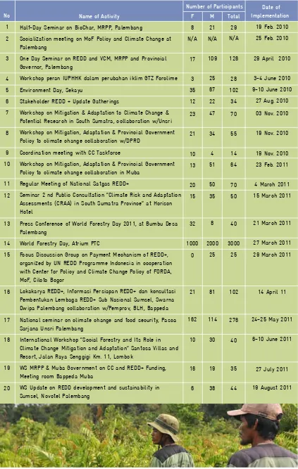
Table 2. List of Climate Change Activities Conducted and Participated
Name of Activity
Half-Day Seminar on BioChar, MRPP, Palembang
Socialization meeting on MoF Policy and Climate Change at Palembang
One Day Seminar on REDD and VCM, MRPP and Provincial Governor, Palembang
Workshop peran IUPHHK dalam perubahan iklim GTZ Forclime
Environment Day, Sekayu
Stakeholder REDD + Update Gatherings
Workshop on Mitigation & Adaptation to Climate Change & Potential Research in South Sumatra, collaboration w/Unsri
Workshop on Mitigation, Adaptation & Provincial Government Policy to climate change collaboration w/DPRD
Coordination meeting with CC Taskforce
Workshop on Mitigation, Adaptation & Provincial Government Policy to climate change collaboration in Muba
Regular Meeting of National Satgas REDD+
Seminar 2 nd Public Consultation “Climate Risk and Adaptation Assessments (CRAA) in South Sumatra Province” at Horison Hotel
Press Conference of World Forestry Day 2011, at Bumbu Desa Palembang
World Forestry Day, Atrium PTC
Focus Discussion Group on Payment Mechanism of REDD+, organized by UN REDD Programme Indonesia in cooperation with Center for Policy and Climate Change Policy of FORDA, MoF, Ciloto Bogor
Lokakarya REDD+, Informasi Persiapan REDD+ dan konsultasi Pembentukan Lembaga REDD+ Sub Nasional Sumsel, Swarna Dwipa Palembang collaboration w/Pemprov, BLH, Bappeda
National seminar on climate change and food security, Pasca Sarjana Unsri Palembang
International Workshop “Social Forestry and Its Role in Climate Change Mitigation and Adaptation” Santosa Villas and Resort, Jalan Raya Senggigi Km. 11, Lombok
F
19 Feb. 2010
25 Feb. 2010
29 April 2010
3-4 June 2010
9-10 June 2010
27 Aug. 2010
03 Nov. 2010
19 Nov. 2010
19 Nov. 2010
23 Feb. 2011
4 March 2011
15 March 2011
21 March 2011
27 March 2011
29 March 2011
14 April 11
24-25 May 2011
6-10 June 2011
Some of the major outcomes of these climate change activities and measures are:
• There is now an increased awareness with all stakeholders including communities about climate change and REDD.
• Forest surrounding communities have started to reduce illegal activities in the MRPP area due to alternative income possibilities.
• Government institutions and stakeholders have increased capacity and competence to address climate change and REDD.
• Networking and advanced collaboration with local and selected international universities and other institutions in the REDD sector and Climate Change has been enhanced at provincial, national and international level.
• The Climate Change Coordination Team of South Sumatra (CCCTSS) is established and has taken on responsibilities.
Biodiversity, aims, activities and results:
• To collect and analyse biodiversity documents and reports, in particular from Merang or other peat swamps in Indonesia or South East Asia. • To assess biodiversity parameters and habitat quality.
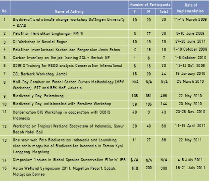
Table 3. List of Biodiversity Activities Conducted and Participated
Name of Activity
Biodiversit and climate change workshop Gottingen University + DAAD
Pelatihan Pendidikan Lingkungan KMPH
CI Workshop in Novotel Bogor
Pelatihan Inventarisasi Karbon dan Pengenalan Jenis Pohon
Carbon Inventory on the job training ZSL + Berbak NP
OSIRIS Training for REDD analysis Conservation International
ZSL Berbark Workshop, Jambi
Half-Day Seminar on Forest Carbon Survey Methodology (MRV Workshop), GTZ and BPK MoF, Jakarta
Biodiversity Day, Palembang
Biodiversity Day, collaborated with Forclime Workshop
Conservation GIS Workshop in cooperation with SCGIS Indonesia
Workshop on Tropical Wetland Ecosystem of Indonesia, Sanur Beach Hotel Bali
One year web Foto Biodiversitas Indonesia and Launching electronic magazine of Biodiversitas Indonesia in Taman Kyai Langgeng, Magelang
Simposium “Issues in Global Species Conservation Efforts” IPB
Asian Wetland Symposium 2011, Magellan Resort, Sabah, Malaysian Borneo
11-15 March 2009
8-10 June 2009
27-28 June 2011
7-10 October 2009
1-6 October 2010
13-14 Oct. 2009
19 January 2010
25 March 2010
22 May 2010
23 May 2010
23-26 Nov. 2010
11-15 April 2011
22 May 2011
4-5 July 2011
18-21 July 2011
Number of Participants
Again the table below gives an overview of important interventions by MRPP regarding biodiversity issues and targeted stakeholders.
The outcomes of these specific biodiversity activities and measures
are:
• Data and information was collected and analysed for setting up studies and surveys to complement data and information.
Forest management unit, aims, activities and results:
• To identify possibilities for future management of the Merang Peat Swamp Forest.
• To support the establishment of a Forest Management Unit with local and national stakeholders.
• Assist first implementation steps on how to develop a management structure (KPHP).
• To engage in capacity and competence building measures for future KPHP personnel.
• To lobby for KPHP at national and local level so that it will advance further and obtain funds from the government.
• To carry out joint activities for the establishment of initial activities and to reduce illegal activities in the field
The FMU concept is not new and has been a target for the Forestry Ministry for many years. However, the process is very slow and it is not on the priority list. For implementation of REDD and decentralisation the KPHP concept would have a number of positive impacts, but would need some better and clearer regulations, in particular when taking on business opportunities (like Carbon Trading). MRPP was therefore very much dependent on how far the national KPHP legislation process allowed decisions to be made on the set up and management.
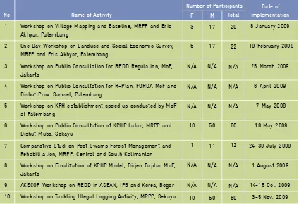
Table 4. List of Forest Management Unit Activities Conducted and Participated
Name of Activity
1 Workshop on Village Mapping and Baseline, MRPP and Eris Akhyar, Palembang
2 One Day Workshop on Landuse and Social Economic Survey, MRPP and Eris Akhyar, Palembang
3 Workshop on Public Consultation for REDD Regulation, MoF, Jakarta
4 Workshop on Public Consultation for R-Plan, FORDA MoF and Dishut Prov. Sumsel, Palembang
5 Workshop on KPH establishment speed up conducted by MoF at Palembang
6 Workshop on Public Consultation of KPHP Lalan, MRPP and Dishut Muba, Sekayu
7 Comparative Studi on Peat Swamp Forest Management and Rehabilitation, MRPP, Central and South Kalimantan
F
8 January 2009
19 February 2009
25 March 2009
6 April 2009
7 May 2009
18 May 2009
24-30 July 2009
Table 4. List of Forest Management Unit Activities Conducted and Participated (continued)
Name of Activity
11 Workshop on Conflict Mapping in Forestry Sector, BP2HP, Palembang
12 Workshop on Land Tenure, WALHI, Palembang
13 Workshop on Public Consultation of KPHP, Dirjen Baplan MoF, Jakarta
14 Workshop on Training Need Assessment of KPH, GTZ and Pusdiklat Bogor, Sekayu
15 Workshop on Training Need Assessment of KPH, GTZ and Pusdiklat Bogor, Sekayu
16 ICOPE Conference, Nusa Dua Bali
17 Half-Day Seminar on Forest Carbon Survey Methodology (MRV Workshop), GTZ and BPK MoF, Jakarta
18 Workshop on Local Community and REDD Issues, WARSI, Jambi
19 Seminar on social forestry concept and experiences, UNSRI, Palembang
20 Workshop on Public Consultation of Grassroot Capacity Need Assessment, GTZ and RECOFTC, Palembang
21 Comparative Studi on KPH, MRPP, East Java and Bali
22 Workshop on UPTD KPH Lessons Learned, GTZ and Dirjen Baplan, Jakarta
23 TNC/WE Workshop on community participation, Jakarta
24 KPH Training at Pusdiklat Bogor
25 Seminar on Expanding Access to Community Forest Management, WBH-Anugrah Hotel
26 Coordination Meeting about KPHP at Forclime and MoF
27 KPH coordination meeting at national level, Bogor
28 Coordination Meeting for Master Plan KPHP Drafting
29 The International Conference on Forest Land Tenure,
Governance and Enterprise, Experiences and Opportunities for Asia in a Changing Context, Lombok
30 Facilitation on Socialitation RKHD & RTHD Documents of Hutan Desa Merang
23 Nov. 2009
16 Nov. 2009
4 Dec. 2009
16-17 Dec. 2009
16-17 Dec. 2009
23-25 Feb. 2010
25 March 2010
8 April 2010
13 April 2010
15 April 2010
17-22 May 2010
31 May-1 June 2010
8-10 June 2010
22 Nov. 2010
1 May 2011
9-10 May 2011 30 May–1 June‘11
8 July 2011
11-15 July 2011
16-18 August 2011
the prospective Head of KPHP, learning through various training, workshops and study tours, and activities during field surveys.
• Established commitment from Government of Musi Banyuasin District and provincial government
• Elaborated and supported the development of a basic collaborative management plan in accordance with the KPHP concept, together with stakeholders.
• Facilitated a Master Plan of Forest Management Unit (KPHP) Lalan-Mangsang-Mendis document as a blue print for long term KPHP management.
• Joint activities / operations implemented to reduce illegal activities with a number of stakeholders.
MRPP first had to focus on the facilitation to set up a FMU and to prepare for the management. With many legal hurdles to take, this process was time consuming and slow. The challenge now is to further strengthen the management and the legal basis for future REDD+ involvement. Peat Swamp Forests are governed by a multitude of laws and regulations and prone to different interpretation. Often good data on forest cover, size and depth of peat is not available. MRPP has managed to survey and study the Merang Block in much detail and all necessary data for future REDD is on hand.
In 2011 MRPP continued to assist communities and NGOs to finalize the process in obtaining village forest licences within the KPHP boundaries. By end of 2011 it is hoped that at least 2 licences are given by the Ministry of Forestry. The challenge for the future is proper management of the village forests. Guidance and support are needed.
2.3
Component 2:
Forest Monitoring, Carbon
Accounting and Fire Management
Component 2 involves technical aspects related to forest measurement and carbon accounting. However, the component has 3 major parts: (1) Forest monitoring and assessment of forest biodiversity, peat swamp characteristics, and threats to the peat swamp forest from illegal activities and forest fires. (2) Carbon accounting for developing baseline emission and reference emission level, through Tier 3 accuracy of emission factors and activity data. (3) Fire management systems that actively involve local communities.
coverage, but also other parameters associated with forest ecosystems, such as soil characteristics, plant and wildlife diversity and threats to the ecosystem. It employs both remote sensing technology and field surveys. Remote sensing technologies are very useful to capture vast areas of forest and land, for forest and vegetation mapping and also fire and hotspot monitoring. Moreover, it is possible to assess historical forest conditions using remote sensing, which are useful for assessing deforestation rates, and thus historical emissions. A terrestrial survey allows us to collect more detailed and comprehensive information about forest attributes. A combination of these two methodologies will give accurate and comprehensive forest information.
We conducted vegetation and land cover mapping for the MRPP project area using remote sensing data. We applied and used the integration of local knowledge on vegetation types in the field and available spectral signatures of remote sensing data to define land cover classes. Moreover, we also differentiated degradation levels of peat swamp forest, since they store different value of carbon stocks. This means, that we were able to identify more classes than those required by the national standard for a land cover classification system. There are 8 land cover classes used for image classification in the MPSF: 3 classes of secondary forests (dense logged-over forest, medium logged logged-over forest, and secondary forest dominated by Macaranga); 2 classes from differentiation of forest re-growth and shrubs, and 3 deforestation classes (grasslands, open/burnt land and recently logged). These 8 land cover classes are useful for stratification of carbon stock assessment.
The illegal logging, conducted by communities with support by a patronage system from rich businessmen, targets most of the commercial trees species with smaller diameters. Other non-commercial trees are also harvested and used to support the wood extraction process, either for making skidding tracks or for floating the timber in the canals and rivers. This has lead to excessive damage to the remaining forest stands.
Monitoring of illegal logging activities was conducted using field surveys as well as remote sensing. In 2009, a survey of illegal logging activities was conducted in cooperation with the University of Muhammadiyah, Palembang (UMP). The survey revealed that loggers operate in small groups of 3-5 persons. Each group can extract around 70 – 100 m3 timber per month. It was estimated that up to 75 illegal logging groups are operating near Merang and Kepahiang Rivers. Loggers annually extract around 57,000 m3 of timber from the area.
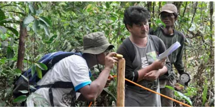
Local communities have been involved in the direct monitoring of illegal logging on a regular basis. Canals and rivers are the only access for illegal timber extraction so it is very effective to monitor the illegal logging traffic from major rivers posts. Two Community Forest Ranger’s (CFR) field stations are situated in the river mouth of the Merang and Kepahiang rivers, where all rafts of illegal logs and timbers have to pass. The field station in the Merang River is very suitable for regular monitoring as it is located in the village where the CFR crews live.
Biodiversity monitoring
Hornbills are also an important key species for peat swamp forest ecosystems and are relatively easily observed due to their size and calls. The surveys conducted by WI and SSFFMP assessed large mammals and most of the large mammals recorded in the 2003 survey were confirmed and found again in the 2008 survey.
In 2009, MRPP conducted a multi-purpose inventory, focusing on biomass measurement in 45 plots, distributed randomly throughout the project area. The inventory leader recorded any indication of wildlife, either through direct observation or indirect evidence such as calls, tracks, faeces, and other signs. GPS points were recorded for each observation. Some remarkable observations were made during the survey, including footprints of the Sumatran Tiger (Panthera tigris), Tapir (Tapirus indicus) and Sun Bear
(Helarctos malayanus).
Two teams who worked separately (one team in Buring river and the other in Kepahyang river) spotted fresh tiger tracks 6 times along a transect. This indicates that at least 2 individual tigers are using the project area and this is substantiated by the relatively good quality of remaining forest and available food - Wild Boar (Sus scrofa), Sambar Deer (Cervus unicolor), Barking Deer (Muntiacus muntjak) and Mouse Deers (Tragulus napu and Tragulus javanicus) are all present. Another large carnivore that was recorded in the project area was the Sunda Clouded Leopard (Neofelis diardi).
Many project field activities can be done in parallel with wildlife
specific survey to assess the gibbon population in the project area will be conducted soon. The Pig-tailed Macaque and Banded Langur need to be monitored regularly, since they are susceptible to forest degradation and deforestation.
Long-tailed Macaque (Macaca fascicularis)
Wetland International conducted the most comprehensive mammal survey in 2003. They used direct observation and secondary information from trusted sources and recorded 20 mammals in the MPSF. During regular field surveys, 3 more species have been found in the area: namely: the Lesser Mouse Deer (Tragulus javanicus); Sunda Clouded Leopard (Neofelis diardi)
and Giand Red Flying Squirrel (Petaurista petaurista).
Based on results from the field inventory, Rengas burung (Melanorrhoea walicchii) is the plant species with the highest Importance Value Index (IVI) in the project area, followed by Punak (Tetramerista glabra) and Ramin
Local allometric biomass equations
Some allometric equations have been developed to accommodate carbon measurement in tropical countries. However, it is more appropriate to estimate tree biomass based on a local allometric equation developed from similar forest types. The nearest forest type to the MPSF that has been studied for allometric equations is a lowland secondary forest in Jambi. However most of the study site is located on mineral soil, hence it will differ to forest on peat land.
MRPP implemented a study for the development of biomass equations in the peat swamp forest at Merang, to get a higher level of precision and accuracy in carbon calculations. In cooperation with the adjacent timber plantation, we used harvesting to develop 2 allometric equations, one for tree species from natural forests and one for pioneer tree species.
For the peat swamp forest equation we used data from 54 dominant trees with a maximum diameter at breast height (DBH) of 102 cm. For the pioneer tree equation we used 22 trees with a maximum DBH of 35 cm.
Forest carbon Inventory
The REDD+ mechanism, requires an internationally accepted carbon monitoring system. The higher the precision level of carbon measurement, the more convenient it would be for validation and verification as well as for carbon trading negotiations. Therefore, a carbon measurement system with accepted accuracy and precision is required at project level.
In MRPP we developed and implemented the Tier 3 carbon accounting methodology. This methodology has been documented and published for further dissemination.
Community-Based Fire Management
From the beginning of the project we have encouraged community involvement for all field activities. Meetings were frequently conducted in villages to raise awareness on climate change and REDD, and on the aims of the project. Activities were jointly planned in order to get commitment and to work together. Based on the many meetings with villagers we
established Community Forest Ranger Groups (CFR) in each village. MRPP and partners provided basic training for environmental education, forest inventory, rehabilitation, and for fire suppression.
In cooperation with Satu Hijau (a local NGO), the District Forest Service and the Manggala Agni Fire Brigade, fire prevention and suppression training was conducted for the CFRs. Annual refresher training was also provided by the project to ensure that the CFRs maintain and improve their skills in fire prevention and suppression.
Forest fire patrols are conducted regularly by the CFRs during the dry seasons. These patrols are used for disseminating information and leaflets on fire dangers and fire alertness to communities and even illegal loggers. A Fire Danger Rating System was established at the MRPP Merang Camp to provide important information on the fire danger levels. The status is assessed and updated daily by the Merang Field Office Manager. This information is sent to each CFR Post of Kommand (Posko). Whenever the fire status reaches the danger level, the Merang Field Office Manager will employ CFR crews for fire patrols and fire suppression.
MRPP provided some basic equipment for patrolling and fire suppression. Future entities involved in the Merang Peat Swamp management will have to maintain and upgrade the equipment, tools and the required skills for the CFRs on a frequent basis.
2.4
Component 3:
Nursery and Rehabilitation
Critical land in the project area has been prioritized for rehabilitation activities. Based on conditions in the field, approximately 8,931 ha (37%) of the recommended 24,092 ha area (Decree Musi Banyuasin Regent No. 522/2235/Kehut/2008) comes under this category. Damage is generally due to forest exploitation activities, especially illegal logging and the opening of canals to transport the timber.
The role of nursery and rehabilitation is to support sustainable natural resource management and biodiversity protection through the rehabilitation of land that has been degraded or deforested.
Local communities are involved in the forest rehabilitation activities in the Merang-Kepayang area as part of the community-based rehabilitation strategy. Starting with seedlings, communities are involved in all stages of implementation from planting, plant maintenance, monitoring to protection.
Aspects of community-based forest rehabilitation:
• Land Use: status of the legality of the area; systems and patterns of land ownership.
• Socio-Economic: the involvement and active participation of
communities; social and economic benefits for community management (KPHP/Production Forest Management Unit, management plans and zoning areas).
• Peat swamp forest (the causes of damage, intervention models and the suitability of plants to the land types).
Based on the above, through cooperation and collaboration schemes on PSF rehabilitation with local communities (Community Forest Ranger/ CFR, in 2 villages) and the Forestry Agency of MUBA District, the intervention needed for MRPP area, is:
• Degraded PSF primary forest: canal blocking, area monitoring and protection, enrichment planting and natural regeneration.
Surveys of vegetation and areas of degraded land have been implemented in the project area in order to gather information on important local species. The survey results for the project site are as follows:
Table 5.Merang-Kepayang Peat Swamp Forest - Type of Damage
Type of Damage Level of Damage
Degraded primary peat swamp forest:
Peat swamp forest that has been
disrupted by logging and fires (among
others) but the conditions and original peat swamp forest vegetation composition are still there, with vegetation density of more than 400 trees / ha
Secondary peat swamp forest: Peat swamp forest that has been turned into a forest with the dominant type of secondary vegetation such as Gelam and tembesu, mainly caused
by fire. Density of small trees and
tree vegetation ranges from 300 - 400 trees / ha
Degraded peat swamp forest: Peat swamp forest cover has been turned into open areas. Shrub and forest cover below 10%, with the density of small trees and vegetation under 300 trees / ha
Minor damage, with the following characteristics:
• Damage to local species
composition and the hydrology of
peat swamp forest by fire, logging
and canals
• No flooding
• Damage to the aspects of hydrology
and forest composition and structure of a logged-over forests from logging and opening of canals,
some flooding alongside rivers in
the rainy season
Moderate damage, with the following characteristics:
• Damage to the peat condition (peat
is shallow and burns) and the species composition of plants into secondary forest
• Due to repetitive fires • No flooding
Moderate damage, with the following characteristics:
• Damage to the peat (top layer),
hydrology and forest cover leading to non-forested or open areas.
• As a result of repeated fires and
the opening of canals.
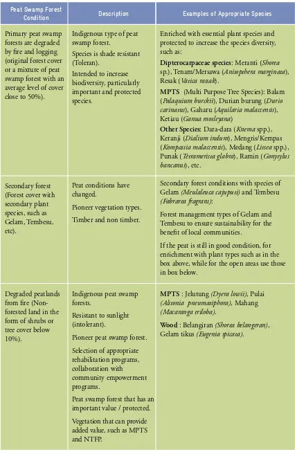
Table 6.Recommendation Indigenous Species for Rehabilitation (MRPP area)
Peat Swamp Forest Condition
Primary peat swamp forests are degraded by fire and logging (original forest cover or a mixture of peat swamp forest with an average level of cover close to 50%).
Secondary forest (Forest cover with secondary plant species, such as Gelam, Tembesu, etc).
Degraded peatlands from fire (Non-forested land in the form of shrubs or tree cover below 10%).
Description Examples of Appropriate Species
Indigenous type of peat swamp forest.
Species is shade resistant (Toleran).
Intended to increase biodiversity, particularly important and protected species.
Peat conditions have changed.
Pioneer vegetation types. Timber and non timber.
Indigenous peat swamp forests.
Resistant to sunlight (intolerant).
Pioneer peat swamp forest. Selection of appropriate
Enriched with essential plant species and protected to increase the species diversity, such as:
Dipterocarpaceae species: Meranti (Shorea sp.), Tenam/Mersawa (Anisopthera marginata), Resak (Vatica rassak).
MPTS (Multi Purpose Tree Species): Balam (Palaquium burckii), Durian burung (Durio carinatus), Gaharu (Aquilaria malaccensis), Ketiau (Ganua motleyana)
Other Species: Dara-dara (Knema spp.), Keranji (Dialium indum), Mengris/Kempas (Kompassia malaccensis), Medang (Litsea spp.), Punak (Tetramerista glabra), Ramin (Gonytylus bancanus), etc.
Secondary forest conditions with species of Gelam (Meulaleuca cajuputi) and Tembesu (Fabrarea fragrans):
Forest management types of Gelam and Tembesu to ensure sustainability for the benefit of local communities.
If the peat is still in good condition, for enrichment with plant types such as in the box above, while for the open areas use those in box below.
MPTS : Jelutung (Dyera lowii), Pulai (Alstonia pneumatiphora), Mahang (Macaranga triloba).
A village nursery was built to provide seedlings for the rehabilitation program in Merang HRG-Kepayang. In addition, this nursery provides revenue to CFR members. Seeds from local species (indigenous tree species) are used. Two additional nurseries, namely Petaling CFR village Kepayang and CFR Tembesu - Merang Muara village, each have a 50,000-seedling capacity.
The nursery uses the knowledge and skills of community members in terms of seedling production for local species, including the production of grafting rubber seedlings (Hevea braziliensis). There are examples of approximately 20 successful local produced species that can be used for seedlings, such as: Kayu Arang (Diospyros siamang); Punak (Tetramerista glabra); Medang (Litsea spp); Pabuh Kijang (Santiria griffithii); Kayu Kelat (Eugenia glauca); Cempedak air (Artocarpus maingayi); Keranji (Dialium indum); Dara-dara (Knema spp); Balam (Palaquium burckii); Geronggang (Cratoxylon arborencens), Meranti (Shorea sp); Labu-labu (Endospermum malaccensis); Uya-uya (Gironniera nervosa); Keluai; Belambang Lanang etc.
Blocking canals as a model of intervention to be used as preparation for rehabilitation of degraded peat lands has been carried out on the Tembesu Daro river and around the Kepayang river.
Implementation of critical land cultivation has been done with a total of 43 ha, as follows:
• Planting an area of 2 ha with Jelutung species (Dyera lowii) and Medang (Litsea sp) at the end of 2009 and in May 2010.
• Planting an area of 26 ha with local species at two sites in December 2010 and January 2011.
• Planting an area of 3 ha with a mixture of plant species including Jelutung (Dyera lowii) and Meranti (Shorea blangeran) in the village Mangsang, as part of a rehabilitation research collaboration with the BPK – Palembang.
• Planting an area of 12 ha with local species in July 2011.
Plant maintenance carried out at locations includes slash line, cleaning planting holes (disk model), replanting, fertilization and plant
monitoring.
Recommendations from the results of the monitoring include plants such as: Punak (Tetramelistra glabra); Medang (Litsea spp); Dara-dara (Knema
spp); Cempedak Air (Artocarpus maingayi); Kelat (Eugenia glauca) Punggung kijang (Santiria griffithii); Balam (Palaquium burckii); Uya-Uya (Gironniera nervosa) and Keranji (Dialium indum) that will all survive in the early days when there is little shade planting.
Cooperation with governmental institutions, university and NGOs is vital to support successful rehabilitation and the nursery. Institutions involved in supporting the transfer of knowledge and training members of the CFR include the MUBA Forest Service, the Provincial Forestry department, BP DAS – Musi, BPK Palembang, BPTH Palembang, BSBTP Palembang UMP, Kemasda NGO and WBH.
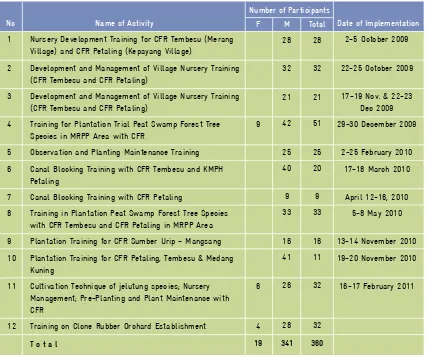
Increased knowledge and developing skills through training has been implemented for members of the CFR with a total of 360 participants that started in October 2009. Details of the training are shown below (Table 7).
Table 7. Nursery and Forest Rehabilitation Training
Name of Activity
1 Nursery Development Training for CFR Tembesu (Merang Village) and CFR Petaling (Kepayang Village)
2 Development and Management of Village Nursery Training (CFR Tembesu and CFR Petaling)
3 Development and Management of Village Nursery Training (CFR Tembesu and CFR Petaling)
4 Training for Plantation Trial Peat Swamp Forest Tree Species in MRPP Area with CFR
5 Observation and Planting Maintenance Training
6 Canal Blocking Training with CFR Tembesu and KMPH Petaling
7 Canal Blocking Training with CFR Petaling
8 Training in Plantation Peat Swamp Forest Tree Species with CFR Tembesu and CFR Petaling in MRPP Area
9 Plantation Training for CFR Sumber Urip - Mangsang
10 Plantation Training for CFR Petaling, Tembesu & Medang
F
9
Date of Implementation
2-5 October 2009
22-25 October 2009
17-19 Nov. & 22-23 Dec 2009
29-30 December 2009
2-25 February 2010
17-18 March 2010
April 12-16, 2010
5-8 May 2010
13-14 November 2010
19-20 November 2010
There are several funding opportunities for rehabilitation and management of village nurseries for a REDD program in the Merang-Kepayang peat swamp forests, as well as for good forest management schemes through KPHP and forest management by communities and the private sector. These are, among others:
• Greenhouse gas emission mitigation funded by central government. • Forest management for village forests in the villages of Muara Merang
and Kepayang, including forest rehabilitation with local seedlings supported by the village nursery.
• Opportunities of cooperation with the private sector through CSR funds (Ex: PT Sinar Mas-RHM; Pertamina; Mining, etc.).
• Rehabilitation program from KPHP Lalan and Forset Service MUBA. • Seedling supply for rehabilitation program DAS MUSI (BPDAS
MUSI).
• The need for a rubber cultivation program in surrounding communities (rubber seedling sales will give business opportunities to the village nursery).
• Management of Merang-Kepayang area in the carbon trading mechanism through REDD.
2.5
Component 4:
Community Development
The adverse impacts of climate change are, among others, disturbances in hydrological cycles bringing changes in rainfall patterns and rising sea levels due to the melting of the ice caps. Excessive floods as well as droughts are likely. A decrease in agriculture and fish production from the changing weather patterns is to be expected. Negative impacts and changes to biological diversity will occur and affect the balance of flora and fauna. Indonesia is still mainly an agricultural country; hence awareness on the causes of climate change and its impacts needs to be increased substantially. Ways and means to reduce the negative impacts will have to be found. The MRPP Community Development (CD) component is assigned to promote and enhance active participation by village communities to reduce the underlying causes of deforestation and degradation to forests in the project area.
Targets and activities of the CD components consist of:
1. Facilitate the establishment of the Community Forest Rangers (CFRs) or Kelompok Masyarakat Peduli Hutan (KMPH); recruited from local village communities.
2. Enhance KMPH members capacity and support institutional strengthening
3. Introduce alternatives for income generating activities (IGA), and facilitate the establishment of groups’ savings and loan schemes to function as embryo for village micro finance service units.
4. Promote and encourage active participation of local communities in forest protection and rehabilitation to enter into the REDD+ compensation mechanism.
From October 2008 until September 2011, MRPP established and regularly facilitated fourteen KMPHs. Two of these KMPHs are core groups and were assigned as village forest fire crews, while the other twelve are extension groups. All of the KMPH members were recruited from local community members of the Merang and Kepayang villages and their sub-villages.
Name
KMPH “Tembesu” – Dsn Bina Desa
KMPH “Petaling” – Ds Kepayang
KMPH “Medang Kuning” – Dsn Bina Desa
KMPH “Pulai Gading” – Ds Kepayang
KMPH “Durian Payo” – Ds Kepayang
KMPH “Merante Jaya” – Dsn Bakung
KMPH “Jelutung Indah”– Dsn Bakung
KMPH “Merawan” – Dsn Buring
KMPH “Wanita mandiri” – Dsn Hijrah Mukti, Mangsang
KMPH “Bunga Anggrek” - Dsn Bakung, Muara Merang
KMPH “Jati Merah” - Dsn Bina Desa
KMPH “Mawar Putih” - Ds Kepayang
KMPH “Urip Mulyo” - KTGR, Dsn II Mangsang
KMPH “Sumber Urip” - Dsn Hijrah Mukti
TOTAL
Table 8. List of CFR/KMPHs established
Name of Activity
Workshop on Gender role awareness for village decision makers at Merang village
Workshop on Gender role awareness for village decision makers at Kepayang village
Training on Management and Group Dynamic for CFR “Tembesu” of Bina Desa SubVillage
Training on Management and Group Dynamic for CFR “Hutan Lestari” of Kepayang village
Training on Technique and Management of Poultry Business as Income Generating Activities for CFRs at Bina Desa Subvillage
Training on Technique and Management of Poultry Business as Income Generating Activities for CFRs at Kepayang village
Training on Management and Group Dynamic for CFR “Jelutung” and “Meranti Jaya”of Merang village
Refresher Training for Forestry Investigator (PPNS) personnel from District and Province Forestry Service at Palembang
Refresher Training for Forestry Police (PolHut) personnel from District and Province Forestry Service at Palembang
Training on Management and Group Dynamic for CFR “Tembesu” and “Medang Kuning” of Bina Desa SubVillage
Training on Households Economy Management for 2 CFRs at Bakung, Merang Village
Training on Households Economy Management for 2 CFRs at Kepayang Village
Training on Management and Group Dynamic for CFR “Merawan” of Buring SubVillage
Training on Agri Bisnis for Community Forest Rangers
Training on Bookkeeping for CFRs’ Savings and Loan Managers
Training on Veterinary for CFRs at MRPP Field
Male
Number of Participants
Date of Implementation
2 February 2009
4 February 2009
19-21 March 2009
28-30 April 2009
19 August 2009
20-21 August 2009
22-24 December 2009
9-10 March 2010
10-11 March 2010
12-14 March 2010
8-10 April 2010
5-7 May 2010
27-29 May 2010
19-20 Aug & 24-25 Sept 2010
4-5 March 2011
12 April 2011
Table 9. CD Trainings and Workshops conducted
Basic
Alternative income generation activities varied considerably according to requests by the groups. Field activities and modules introduced and supported included poultry production, animal husbandry (cattle, goat rearing), and the establishment of home and agribusinesses such as village shops, the production of snacks, etc.
One of the examples is the poultry rearing conducted by Pak Effendy, “Pulai Gading” CFR member of Kepayang village. He could manage a rotation of 4 rearing’s per year, each consisting of 1 box of 100 baby chickens (IDR 750.000 per box), with a rearing period of 38 days. Sold chickens weighed between 1.8 - 1.7 Kg/head. During the rearing period the chickens consumed 4 bags of pellet of 50 kg each (IDR 310,000/bag). When using recommended chicken medicines around 85% of the small chickens survived and could be sold after rearing.
Table 10. Example of Cost Benefit Analyses of Pak Effendi’s Chicken Rearing for 1
year (4 rotations).
Expenditure and Revenue
A. Expenditure (Cost)
- DOC ( 4 x 750.000,-)
- Pellet ( 4 x 4 X 310.000,-)
- Medicines (4 X 50.000,-)
- Cage reduction
Total
B. Revenue
- Selling (1, 75 x 85 x 4 )= 595 Kg
@ 27.000/kg = ( 595 x Rp 27.000 )
Total
C. Benefit
FCR
R/C
IDR
3.000.000
4.960.000
200.000
125.000
8.285.000
16.065.000
16.065.000
7.780.000
1,14
1.94
Food/Cost ratio indicates the efficiency of chicken food provided. Based on the above analyses, the R/C of 1.94 shows that the chicken rearing business is a promising alternative for additional income generation at household level.
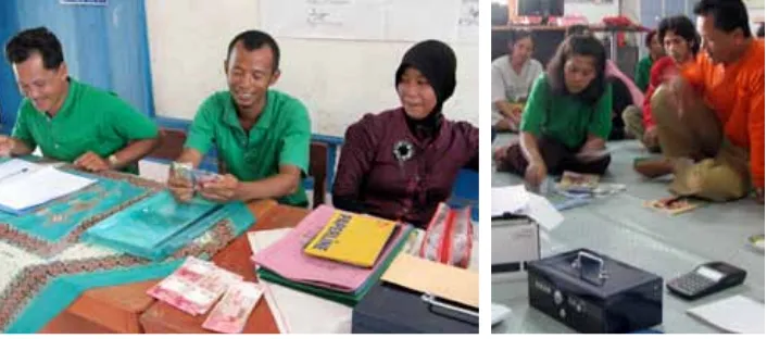
To substantially increase household and village incomes, MRPP introduced local subsidies to establish saving and loan schemes that could be managed by the groups. This required an increase in the management capacity and competence of the groups. NGOs and MRPP did this on a continuous basis until the end of the project.
Recipient CFR
Women’s group
Women’s group
Women’s group
Women’s group
Table 11. List of CFRs’ alternative income generating activities, supported by MRPP. Local subsidy
disbursed for seed capital strengthening for CFR’s savings and loan schemes 2009 - 2010.
Village/Sub-Hijrah Mukti, Mangsang
Bakung, Muara Merang
Bina Desa
Kepayang
Kepayang
Activities
Goat, Micro Credit
Micro Credit
Micro Credit
Micro Credit
Total:
Rubber Micro Credit Gardening tools, Horticulture, Cattle
Cattle, Micro Credit, Chicken
Cattle, Micro Credit, Chicken
Chicken, Micro Credit
Home Industry Micro Credit
Rubber, goat Micro Credit Micro Credit
Rubber, Chicken
Total from AWP I: 2009
Seed Capital Local Subsidy
IDR
AWP II: 2010
The disbursement process for local subsidies was:
1. Local Subsidy (LS) allocated in the project’s Annual Work Plan (AWP) 2. The LS budget availability informed to the community forest rangers
(CFR) group during monthly/regular facilitation by project and NGO 3. Facilitated by NGO, CFR provided and submitted the proposal on
strengthening of seed capital of the group’s saving and loans scheme (revolving fund) to the project for local subsidy support. The group proposal consists of:
a. CFR profile
b. Activities being planned
c. Financial/subsidy support needed (summarized from individual group member’s proposal)
4. Agreement of Collaboration established and signed between CFR and MRPP represented by Community Development Specialist, witnessed by Village Head and NGO facilitator. The agreement particularly focused on promotion of active participation of group members for the protection and rehabilitation of the Merang Kepayang Peat Swamp Forest, and the provision of a Local Subsidy for revolving funds to support the income generating activities of the group members. The agreement stipulated obligations and rights of parties.
5. Brief contract for Local Subsidies signed between GIZ represented by Principal Advisor and the CFR, witnessed by NGO facilitator.
6. Disbursement of the Local Subsidy from project to the CFR as end beneficiary, facilitated and witnessed by NGO facilitator.
7. Facilitation, monitoring and reporting of implementation and progress of the use of the local subsidy as revolving fund, conducted by project and NGO facilitator on a regular basis. NGO facilitator contracted by GIZ.
A good example for such a revolving fund is from the “Merante Jaya” CFR of Muara Merang village. Monitoring yielded these results:
The proper set up and the management of such revolving funds / saving and loan schemes was only possible to work in collaboration with a local NGO, Yayasan Kemasda. The NGO - supported by MRPP - provided regular and continuous facilitation for groups and their institutional strengthening on a regular basis. If possible, future parties managing the Merang Peat Swamp Forest should continue such facilitation.
To instil a sense of care for the environment, active participation of the CFRs members in many environmental protection activities was
• Community group’s micro finance service/savings and loan scheme as embryo of future village micro-finance institution established and supported.
• Farmer groups’ institution as well as its members‘ capacity enhanced through regular facilitation, training and workshops for self-reliance and sustainability.
• Pre-condition of groups’ capacity and networking for potential further support from government and/other donors established.
• Appropriate management and technology of alternative IGAs delivered for further replication.
• Groups’ sustainable micro finance services are available for further diversification of IGAs or to increase agricultural production and farmers income in general.
• For sustainability and further facilitation of the CFR groups, all of the 14 CFR groups have been officially registered and handed over to the local agricultural extension office (the Balai Penyuluhan Pertanian, Perikanan dan Kehutanan - BP3K) of Bayung Lencir sub district. The BP3K is the relevant and a competent government agency with responsibilities for further facilitation of the farmer groups in the area. To sum up, the result chain below displays the links and interactions necessary to achieve the desired impacts. It reflects the approaches used and the interventions applied by MRPP for the community development component.
Results Chain of the Merang REDD Pilot Project Community Development component.
• Increase agricultural production and farmers income • Additional income from IGA diversification
• Village micro entrepreneurs have access to sustainable micro finance services
• Community groups established and strengthened • Pilot for IGAs and / or other agri-businesses
• Village micro finance service/savings and loan institution(s) established Intermediate
Outcomes including use of Output
Impacts
• Reduced deforestation and forest degradation • Improved management of natural resources • Increased prosperity level (in combination with other components)
Objective
• Potential further support from government agencies and other donors • Appropriate alternative IGAs / other agri-businesses for replication
• Micro credit finance services for strengthening or diversifying IGAs
2.6
Component 5:
Information, Communication and
Knowledge Management
The major aims of MRPP II and component 5 were:
• Lessons learnt and experiences of the MRPP are available to relevant national and international stakeholders
• Networking between other donor initiatives to reduce deforestation and degradation of peat
ICVKM activities could only start fully in January 2010, with funds from MRPP II and new recruited staff. Before this date other specialists and staff had to fulfil this function in addition to their own assigned tasks.
The year 2010 marked significant achievements for MRPP II. First, the ICVKM concept was developed and activities to put it into practice were designed with input from the stakeholders at a planning workshop for the AWP II. The implementation of these activities yielded the following results: • Information, Communication, Visibility and Knowledge Management
activities have made the GIZ MRPP a worldwide brand. It is described as one of the leading projects among REDD + forest carbon projects. • Since the Technical Agreement between Ministry of Forestry and
GIZ MRPP was signed on 26 July 2010, the project legally became a Indonesia REDD Demonstration Activity.
• Given the DA status, MRPP has been an active member at numerous meetings, gatherings, national exhibitions and conferences addressing national and international experts. This helped rise the awareness of the project and increased interaction with local, national and international stakeholders.
• Locally, the project supported the establishment and consolidation of a number of forums like the Coordination and Technical Team of Climate Change of South Sumatra, the Multi-stakeholder Forum CSR of Musi Banyuasin and the BPDAS Musi Forum.
• Internationally, through its website and exchanges at international and national conferences and workshops, MRPP has made contacts with many researchers, university students, media representatives and other projects from all over the world.
• Media coverage is extensive, MRPP has nor only been been featured at national and provincial level but also on DWTV German, Danish TV and Al-Jazeera TV. Beside that, many national and international printing media have featured MRPP.
• For information and documentation, as well as for the participation at many events all types of printed and digital media have been produced and disseminated, among them: reports, leaflets, books, discs, campaign accessories, stickers, pins, hats, bags, notice boards at strategic locations, etc.
• An internal specific library contains a vast amount of literature on relevant subjects and many study reports and documents collected from sources in Indonesia and outside. More basic village libraries were started in two villages with a focus on agriculture and forestry. • Networking was enhanced and coordination between stakeholders
strengthened. Decision makers in South Sumatra, Indonesia and the region were facilitated to establish contacts and to participate in important climate change issues.
• The intensive collaboration with all the stakeholders was