Open Geospatial Consortium
Publication Date: 2014-07-16
Approved Date: 2014-06-14
Posted Date: 2014-05-15
Reference number of this document: OGC 14-029r2
Reference URL for this document: http://www.opengeospatial.net/doc/PER/testbed10/virtual-gaz
Category: Public Engineering Report
Editor:Martin Klopfer
OGC
®Testbed 10 Virtual Global Gazetteer Engineering
Report
Copyright © 2014 Open Geospatial Consortium
To obtain additional rights of use, visit http://www.opengeospatial.org/legal/.
Warning
This document is not an OGC Standard. This document is an OGC Public Engineering Report created as a deliverable in an OGC Interoperability Initiative and is not an official position of the OGC membership. It is distributed for review and comment. It is subject to change without notice and may not be referred to as an OGC Standard. Further, any OGC Engineering Report should not be referenced as required or mandatory technology in procurements.
Document type: OGC® Engineering Report Document subtype: NA
Document stage: Approved for public release
Abstract
This document provides a technical description of the Virtual Global Gazetteer implemented for OGC Testbed 10.
The Virtual Global Gazetteer integrates two gazetteers – a copy of the USGS gazetteer containing domestic names and a copy of the NGA gazetteer containing non-domestic names (hosted by Interactive Instruments) and provides the capability to link to additional local gazetteers and linked data information, allowing a user to retrieve extended information on locations selected from either of the initial gazetteers. The access to linked data information provided by these gazetteers was achieved by GeoSPARQL enabling these gazetteers using semantic mapping components
Keywords
Ogcdoc, ogc documents, Testbed10, gazetteer, geosparql, wfs, linked data,semantic mediation
Preface
A significant part of the OGC standards development process is the Interoperability Program (IP), which conducts international interoperability initiatives such as Testbeds, Pilot Projects, Interoperability Experiments, and Interoperability Expert Services. These activities are designed to encourage rapid development, testing, validation, demonstration and adoption of open, consensus based standards and best practices.
License Agreement
Permission is hereby granted by the Open Geospatial Consortium, ("Licensor"), free of charge and subject to the terms set forth below, to any person obtaining a copy of this Intellectual Property and any associated documentation, to deal in the Intellectual Property without restriction (except as set forth below), including without limitation the rights to implement, use, copy, modify, merge, publish, distribute, and/or sublicense copies of the Intellectual Property, and to permit persons to whom the Intellectual Property is furnished to do so, provided that all copyright notices on the intellectual property are retained intact and that each person to whom the Intellectual Property is furnished agrees to the terms of this Agreement.
If you modify the Intellectual Property, all copies of the modified Intellectual Property must include, in addition to the above copyright notice, a notice that the Intellectual Property includes modifications that have not been approved or adopted by LICENSOR. THIS LICENSE IS A COPYRIGHT LICENSE ONLY, AND DOES NOT CONVEY ANY RIGHTS UNDER ANY PATENTS THAT MAY BE IN FORCE ANYWHERE IN THE WORLD.
THE INTELLECTUAL PROPERTY IS PROVIDED "AS IS", WITHOUT WARRANTY OF ANY KIND, EXPRESS OR IMPLIED, INCLUDING BUT NOT LIMITED TO THE WARRANTIES OF MERCHANTABILITY, FITNESS FOR A PARTICULAR PURPOSE, AND NONINFRINGEMENT OF THIRD PARTY RIGHTS. THE COPYRIGHT HOLDER OR HOLDERS INCLUDED IN THIS NOTICE DO NOT WARRANT THAT THE FUNCTIONS CONTAINED IN THE INTELLECTUAL PROPERTY WILL MEET YOUR REQUIREMENTS OR THAT THE OPERATION OF THE INTELLECTUAL PROPERTY WILL BE UNINTERRUPTED OR ERROR FREE. ANY USE OF THE INTELLECTUAL PROPERTY SHALL BE MADE ENTIRELY AT THE USER’S OWN RISK. IN NO EVENT SHALL THE COPYRIGHT HOLDER OR ANY CONTRIBUTOR OF INTELLECTUAL PROPERTY RIGHTS TO THE INTELLECTUAL PROPERTY BE LIABLE FOR ANY CLAIM, OR ANY DIRECT, SPECIAL, INDIRECT OR CONSEQUENTIAL DAMAGES, OR ANY DAMAGES WHATSOEVER RESULTING FROM ANY ALLEGED INFRINGEMENT OR ANY LOSS OF USE, DATA OR PROFITS, WHETHER IN AN ACTION OF CONTRACT, NEGLIGENCE OR UNDER ANY OTHER LEGAL THEORY, ARISING OUT OF OR IN CONNECTION WITH THE IMPLEMENTATION, USE, COMMERCIALIZATION OR PERFORMANCE OF THIS INTELLECTUAL PROPERTY. This license is effective until terminated. You may terminate it at any time by destroying the Intellectual Property together with all copies in any form. The license will also terminate if you fail to comply with any term or condition of this Agreement. Except as provided in the following sentence, no such termination of this license shall require the termination of any third party end-user sublicense to the Intellectual Property which is in force as of the date of notice of such termination. In addition, should the Intellectual Property, or the operation of the Intellectual Property, infringe, or in LICENSOR’s sole opinion be likely to infringe, any patent, copyright, trademark or other right of a third party, you agree that LICENSOR, in its sole discretion, may terminate this license without any compensation or liability to you, your licensees or any other party. You agree upon termination of any kind to destroy or cause to be destroyed the Intellectual Property together with all copies in any form, whether held by you or by any third party. Except as contained in this notice, the name of LICENSOR or of any other holder of a copyright in all or part of the Intellectual Property shall not be used in advertising or otherwise to promote the sale, use or other dealings in this Intellectual Property without prior written authorization of LICENSOR or such copyright holder. LICENSOR is and shall at all times be the sole entity that may authorize you or any third party to use certification marks, trademarks or other special designations to indicate compliance with any LICENSOR standards or specifications.
This Agreement is governed by the laws of the Commonwealth of Massachusetts. The application to this Agreement of the United Nations Convention on Contracts for the International Sale of Goods is hereby expressly excluded. In the event any provision of this Agreement shall be deemed unenforceable, void or invalid, such provision shall be modified so as to make it valid and enforceable, and as so modified the entire Agreement shall remain in full force and effect. No decision, action or inaction by LICENSOR shall be construed to be a waiver of any rights or remedies available to it.
Contents
Page1 Introduction ... 1
1.1 Scope ... 1
1.2 Document contributor contact points ... 2
1.3 Future work ... 2
5 Virtual Global Gazetteer overview ... 9
6 Gazetteer Schema ... 10
6.1 Introduction ... 10
6.2 Gazetteer UML model ... 10
6.3 ISO19112 XML Schema ... 11
6.4 Identified Issues ... 11
7 Use Case and Demo Scenarios for the Virtual Global Gazetteer ... 12
7.1 Obtaining information from linked data on a location ... 12
7.1.1 Gazetteer Linking ... 12
7.1.2 Conflation ... 15
7.2 Finding features with specific attributes ... 16
7.2.1 Finding Saint John - Fuzzy Search ... 16
7.2.2 Tallest Mountain within 150 Miles of Saint John – Radial Search ... 16
7.2.3 Closest Airport to Highest Mountain – Near Search ... 17
8 Virtual Global Gazetteer Query Requirements ... 17
8.1 Introduction ... 17
8.2 Query by Name ... 18
8.2.1 Starts with ... 18
8.2.2 Ends with ... 19
8.2.3 PropertyContains ... 19
8.2.4 Fuzzy string matching ... 22
8.3 Query by Feature Description ... 25
8.4 Query by Country ... 26
8.5 Query by Spatial Constraint ... 27
8.5.1 Radial search ... 27
8.5.2 Nearest Neighbour ... 28
9 Architecture Enhancements ... 31
9.1 Cascading WFS accessing NGA and USGS Gazetteer ... 31
9.2 Architecture ... 31
9.3 WFS-C Implementation Issues ... 32
9.3.1 Compatibility matrix ... 32
9.3.2 Merging capabilities document ... 32
9.3.3 maxFeatures/count handling ... 32
9.4 Performance and effort ... 33
9.4.1 Performance Tests ... 33
9.4.2 Caching options ... 34
9.4.3 Fault Tolerance ... 34
10 Semantic Mediation in Testbed-10 ... 36
10.1 Introduction ... 36
10.2 Testbed-10 Approach ... 36
10.2.1 Request transformation ... 37
10.2.2 XPath references ... 37
10.2.3 PropertyIsSemanticallyRelatedTo Operator ... 38
10.3 Implementation issues ... 38
10.3.1 Stored queries ... 38
10.3.2 Advanced filtering operators ... 38
10.4 Conclusions and future work requirements ... 38
10.4.1 Standardization of the core geospatial ontologies ... 39
10.4.2 Best practices to publish geospatial linked data ... 39
10.4.3 Cleanup of the GeoSPARQL standard ... 39
10.4.4 Definition of vertical ontologies ... 40
10.4.5 Migration of OGC services to REST-based semantic enabled web services ... 40
11 Gazetteer Linking ... 41
11.1 Gazetteer Linking Concept ... 41
11.2 Interface Concept ... 42
11.3 Semantic Mapping components ... 43
11.3.1 Geoname semantic mapping ... 45
11.3.2 WFS-G Mapping ... 45
11.4 Best Practices for Gazetteer Data in RDF ... 47
11.5 Process ... 47
11.5.1 Preparation: ... 47
11.5.2 Sequence: ... 47
11.6 Recommendations ... 48
12 Gazetteer Conflation ... 49
12.3.1 User Inputs ... 50
12.3.2 Source Parameters ... 51
12.3.3 Source Data Preparation (Filtering) ... 51
12.3.4 Feature Level Processing - Select Target Features Within N Miles of Source Feature ... 52
12.3.5 Feature Level Processing - Calculate FuzzyWuzzy Score and Distance ... 52
12.3.6 Feature Level Processing - Sort Results by FuzzyWuzzy Score (Descending) and Distance (Ascending) ... 53
12.3.7 Feature Level Processing - Select Results > FuzzyWuzzy Threshold ... 54
12.3.8 Source Gazetteer Dataset Processing - Combine All Results ... 54
12.3.9 Source Gazetteer Dataset Processing - Select Best Result > FuzzyWuzzy Threshold ... 55
12.3.10 Feature Level Processing - Export Results ... 55
12.3.11 Result handling in the Virtual Global Gazetteer Client ... 57
13 Conclusions and Recommendations ... 58
13.1.1 Managing potential failovers ... 58
13.1.2 WFS-G: PropertyMatches operator ... 58
13.1.3 WFS-G: Radial Search support ... 58
13.1.4 WFS-G: Use of Parent Property for locations ... 58
13.1.5 WFS-G: Ambiguous top level container ... 58
13.1.6 WFS-G: Update WFS-G Best Practices for WFS 2.0 ... 59
13.1.7 Semantic Gazetteer Ontology and API ... 59
13.1.8 Standardization of the core geospatial ontologies ... 59
13.1.9 Best practices to publish geospatial linked data ... 59
13.1.10 Cleanup of the GeoSPARQL standard ... 59
13.1.11 Definition of vertical ontologies ... 60
13.1.12 Migration of OGC services to REST-based semantic enabled web services ... 60
14 Data sources ... 61
14.1 WFS-G for USGS ... 61
14.2 WFS-G for NGA ... 61
14.2.1 WFS-G BP V1.0.0 compliant ... 62
14.2.2 "simple" WFS-G schema (OWS-9) compliant ... 62
14.3 NGA-GeoNames.org Link File ... 62
14.4 WFS-G for Local WFS (New Brunswick) ... 62
14.5 New Brunswick Populated Place Link File ... 63
14.6 Geonames database ... 64
14.7 DBPedia ... 64
14.8 LinkedGeoData ... 65
14.9 Provenance SPARQL endpoint ... 65
15 References ... 66
Figures
PageFigure 1 – ISO19112 UML Model ... 10
Figure 2 - Virtual Global Gazetteer Architecture ... 31
Figure 3 – Response times vs. returned features ... 33
Figure 4 - Request transformation process ... 37
Figure 5 – Gazetteer linking concept ... 42
Figure 6 – interface concept ... 43
Figure 7 – concept of selecting resources ... 43
Figure 9 – KMS layer model ... 44
Figure 10 – semantic mapping approach ... 45
Figure 11 – spatial feature selection concept ... 52
OGC
®Testbed 10 Virtual Global Gazetteer Engineering
Report
1 Introduction
1.1 Scope
This document provides a technical description of the Virtual Global Gazetteer implemented for the OGC Testbed 10.
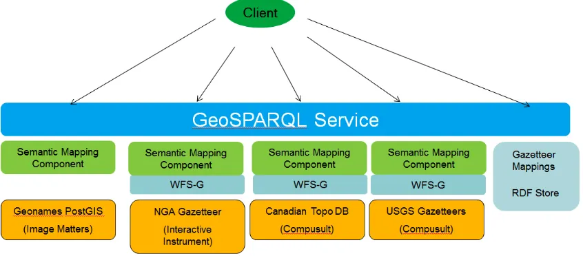
The Virtual Global Gazetteer integrates two gazetteers – a copy of the USGS gazetteer containing domestic names (hosted by Compusult) and a copy of the NGA gazetteer containing non-domestic names (hosted by Interactive Instruments) and provides the capability to link to additional local gazetteers and linked data information, allowing a user to retrieve extended information on locations selected from either of the initial gazetteers. The access to linked data information provided by these gazetteers was achieved by GeoSPARQL enabling these gazetteers using semantic mapping components (provided by Image Matters LLC) mapping RDBMS and WFS data to knowledge representation (RDF) on the fly, which is described in clause 11.
The work addressed fictional real world scenarios described in clause 7, which define a number of query capabilities such query by name, feature description, country and spatial constraint. Encoding examples for the queries are provided in clause 8.
Since the Testbed-10 gazetteer work extended the achievements of the related OWS-9 thread, the previous cascading WFS architecture approach and the current requirements for enhancements are discussed in clause 9. The approach used by Image Matters to semantically-enabled existing data stores (Geonames stored in a PostGIS database) and services (USGS, NGA, Geobase WFS-Gs) by providing a GeoSPARQL interface on top of existing data APIs (SQL and OGC Query) was explored during Testbed-10 and can be considered as an alternative to the syntactic approach used in OWS9.
requests towards a future revision of the WFS-G BP. A detailed documentation of the underlying principles has been addressed in OWS-9 (cf. OGC 12-103r3).
Gazetteer conflation has been utilized to match entries from multiple names sources, sharing or replacing attribute information, and presenting the fused results to users. For the Testbed 10 scenario the NGA gazetteer populated place features were matched with the New Brunswick gazetteer populated place features, creating a table of links between the two data sets and offering the user information on the matching level. The process is described in clause 12, a detailed discussion of conflation is contained in the Testbed-10 CCI Provenance ER (cf. OGC 14-001r).
Issues experienced during the implementation are discussed in the respective clauses and resulted in a number of change requests and recommendations for future work. To ensure they receive appropriate attention in subsequent activities, these have been summarized in clause 13.
This ER concludes with a description of the utilized data sources.
1.2 Document contributor contact points
All questions regarding this document should be directed to the editor or the contributors:
Name Organization
Luiz Bermudez Open Geospatial Consortium
Doug Caldwell U.S. Army Corps of Engineers
Rob Cass Compusult
Stephane Fellah Image Matters LLC
Gobe Hobona Envitia
Martin Klopfer IGSI
David Wesloh NGA
1.3 Future work
A number of issues were identified in the Virtual Global Gazetteer thread, which are discussed in the respective clauses of this report. To ensure they receive appropriate attention in subsequent activities, these have been summarized in clause 13.
1.4 Forward
Recipients of this document are requested to submit, with their comments, notification of any relevant patent claims or other intellectual property rights of which they may be aware that might be infringed by any implementation of the standard set forth in this document, and to provide supporting documentation.
2 References
The following documents are referenced in this document. For dated references, subsequent amendments to, or revisions of, any of these publications do not apply. For undated references, the latest edition of the normative document referred to applies. OGC 09-025r1, OGC Web Feature Service 2.0 Interface Standard (also ISO 19142) OGC 09-026r1, OGC Filter Encoding 2.0 Encoding Standard
OGC 11-122r1, WFS Gazetteer Application Profile
OGC 12-103r3, OWS-9 Engineering Report - CCI – Semantic Mediation
OGC 12-104, OWS-9 Engineering Report - CCI - Single Point of Entry Global Gazetteer OGC 10-100r3, Geography Markup Language (GML) simple features profile
OGC 06-121r3, OGC® Web Services Common Standard
OGC 11-052r4 OGC® GeoSPARQL - A Geographic Query Language for RDF Data OGC 14-001 OGC® Testbed 10 CCI Provenance Engineering Report
OGC 14-021r2 OGC® Testbed 10 CCI Profile Interoperability Engineering Report OGC 14-049 OGC® Testbed 10 CCI Ontology Engineering Report
3 Terms and definitions
For the purposes of this report, the definitions specified in Clause 4 of the OWS Common Implementation Standard [OGC 06-121r3] shall apply. In addition, the following terms and definitions apply.
3.1 Attribute <XML>
name-value pair contained in an element [ISO 19136:2007]
3.2 client
software component that can invoke an operation from a server [ISO 19128:2005]
3.3 coordinate
one of a sequence of n numbers designating the position of a point in n-dimensional space
[ISO 19111:2007]
3.4 coordinate reference system
coordinate system that is related to an object by a datum
[ISO 19111:2007]
3.5 coordinate system
set of mathematical rules for specifying how coordinates are to be assigned to points [ISO 19111:2007]
3.6 element <XML>
basic information item of an XML document containing child elements, attributes and character data
[ISO 19136:2007]
3.7 feature
abstraction of real world phenomena [ISO 19101:2002]
NOTE A feature can occur as a type or an instance. The term "feature type" or "feature instance" should be used when only one is meant.
3.8 feature identifier
identifier that uniquely designates a feature instance
3.9 filter expression
predicate expression encoded using XML [ISO 19143]
3.11 interface
named set of operations that characterize the behaviour of an entity [ISO 19119:2005]
3.12 Linked Data
A pattern for hyperlinking machine-readable data sets to each other using Semantic Web techniques, especially via the use of RDF and URIs. Enables distributed SPARQL queries of the data sets and a browsing or discovery approach to finding information (as compared to a search strategy). Linked Data is intended for access by both humans and machines. Linked Data uses the RDF family of standards for data interchange (e.g., RDF/XML, RDFa, Turtle) and query (SPARQL). If Linked Data is published on the public Web, it is generally called Linked Open Data.
[W3C http://www.w3.org/TR/ld-glossary/]
3.13 Multipurpose Internet Mail Extensions (MIME) type
media type and subtype of data in the body of a message that designates the native representation (canonical form) of such data
[IETF RFC 2045]
3.14 namespace <XML>
collection of names, identified by a URI reference which are used in XML documents as element names and attribute names
[W3C XML Namespaces]
3.15 operation
3.16 property
facet or attribute of an object, referenced by a name [ISO 19143]
3.17 request
invocation of an operation by a client [ISO 19128:2005]
3.18 response
result of an operation returned from a server to a client [ISO 19128:2005]
3.19 response model
schema defining the properties of each feature type that can appear in the response to a query operation
NOTE This is the schema of feature types that a client can obtain using the DescribeFeatureType operation (cf. Clause 9).
3.20 schema
formal description of a model [ISO 19101:2002]
NOTE In general, a schema is an abstract representation of an object's characteristics and relations to other objects. An XML schema represents the relationship between the attributes and elements of an XML object (for example, a document or a portion of a document).
3.21 schema <XML Schema>
collection of schema components within the same target namespace [ISO 19136:2007]
EXAMPLE Schema components of W3C XML Schema are types, elements, attributes, groups, etc.
3.22 server
particular instance of a service [ISO 19128:2005]
3.23 service
3.24 service metadata
metadata describing the operations and geographic information available at a server [ISO 19128:2005]
3.25 Uniform Resource Identifier
unique identifier for a resource, structured in conformance with IETF RFC 2396 [ISO 19136:2007]
NOTE
The general syntax is <scheme>::<scheme-specified-part>.
The hierarchical syntax with a namespace is <scheme>://<authority><path>?<query>
3.26 Symbol
A “symbol” is essentially a “bitmap or vector image that is used to represent a point.
3.27 Symbol Table
4 Conventions
4.1 Abbreviated terms
API Application Program Interface CRS Coordinate Reference System ER Engineering Report
FES Filter Encoding Standard GML Geography Markup Language
GMLSF Simple Feature Geography Markup Language HTTP Hypertext Transfer Protocol
KVP Keyword-Value Pair
MIME Multipurpose Internet Mail Extensions NGA National Geospatial-Intelligence Agency OWL Ontology Web Language
RDF Resource Description Framework
SPARQL SPARQL Protocol and RDF Query Language UML Unified Modelling Language
USGS United States Geological Survey WFS Web Feature Service
WFS-C Cascading Web Feature Service XML Extensible Markup Language
5 Virtual Global Gazetteer overview
The Virtual Global Gazetteer effort extended the Single Point of Entry Global Gazetteer (SPEGG) work from OWS-9, building on the framework established in the earlier testbed and expanding gazetteer functionality to include gazetteer conflation and gazetteer linking.
The key task in this thread focused on the development of an enhanced Virtual Global Gazetteer Client, advancing fault-tolerant capabilities, and opening the service to the wider community for comment.
There are two agencies in the United States in charge of maintaining the official gazetteers:
The USGS gazetteer manages all domestic place names, accessible through a WFS 2.0
The NGA gazetteer manages all non-domestic place names, accessible through a WFS 1.1.0
Both gazetteers not only run on different WFS versions with different capabilities, but also utilize the proprietary data and classification schemes of each organisation. Hence a query, e.g. for a <summit>, needs to be mapped to a query for <elevated point> for the NGA service and <hill> for the USGS service to ensure the client receives all relevant matches from both underlying services.
The basic requirements and concepts from OWS-9 remains largely unchanged for the Virtual Global Gazetteer, with the notable difference that in Testbed-10 the Gazetteer is expected to access large scale data-sets, as opposed to a limited demo data-set in OWS-9. In addition the requirements were extended to include query filters for <country> and <feature type>.
Extended gazetteer linking capabilities support tapping into information services beyond the NGA and USGS gazetteers. Once the desired location is selected from either gazetteer, linked information such as DBPedia, LinkedGeoData (OpenStreet Map Data), Geonames (through Image Matters GeoSPARQL ), Canadian Geobase can be accessed in a unified way using (Geo)SPARQL protocol and query language.
6 Gazetteer Schema
6.1 Introduction
The common schema used for the USGS and NGA gazetteers is the Document OGC 11-122r1 Gazetteer Service - Application Profile of the WFS Best Practice. Approval Date: 2012-01-30, available at: http://www.opengis.net/doc/wfs-gaz-ap.
This schema is the result of previous OWS work and based on an XML encoding of the data model found in ISO-19112, “Geographic information -- Spatial referencing by geographic identifiers”. The advantage of the WFS-G schema is that the USGS and NGA servers can be cascaded without the need to perform a schema translation.
The following subclauses have been adapted from OGC 12-104, OWS-9 Engineering Report - CCI - Single Point of Entry Global Gazetteer, with an added discussion on the implication of the extended query filter requirements.
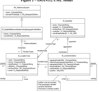
6.2 Gazetteer UML model
Figure 1 illustrates the UML model – taken from ISO-19112 -- that defines the data model offered by the Virtual Global Gazetteer .
All place names offered by a gazetteer are instances of SI_LocationInstance. Each location instance may be classified as being of a specific type and each location type offered by a gazetteer is an instance of SI_LocationType.
A primary function of the semantic mediator (cf. OGC 12-102r3) is to map equivalent location types between the USGS and NGA gazetteers thus allowing clients to query by location type using either vocabulary.
6.3 ISO19112 XML Schema
As has already been mentioned (cf. 6.1) both the USGS and NGA gazetteers implement the ISO19112 UML model (cf. 6.2). In addition, because of previous work (cf. OGC 11-122r1) both servers implement the same XML realization of the ISO19112 model commonly referred to as ISO 19112 “lite”.
The ISO 19112 “lite” XML schema implemented by the USGS and NGA servers is encoded as a GML (cf. OGC 07-036) application schema using the level 1 of the Geography Markup Language (GML) simple features profile (cf. OGC 10-100r3).
The XML schema for ISO19112 can be found in ANNEX A.
6.4 Identified Issues
Three change requests to the current WFS-G Best Practices have been identified:
1. The parent property is not appropriate for locations due to its implication of inheritance (within Object Oriented modeling). Another reason is that the parent property implies a parent-child relationship whereas its role attribute may imply different relationships such as 'in_country', potentially contradicting the parent relationship. This could lead to incorrect interpretation of values due to ambiguity of the parent property or its role attribute.
The resulting change request suggests replacing the parent property with a 'relation' property with tagged value for role.
2. The WFS-G BP specifies that the top level container should be an iso19112:SI_Collection element but then gives an example that uses a wfs:FeatureCollection element. This will lead to exceptions if clients do not know what top-level container (root element) to expect.
The resulting change request suggests to constrain the WFS-G Response to providing wfs:FeatureCollection as the top-level container.
the resource). To perform semantic mapping from XML to RDF, the current approach requires an expensive call to WFS, parsing a new GML document to extract its gml:id so reconstruction of the non-information resource URI can be done (namespace+gml:id). Xlink (and RDF references for that matter) will only work if you use a non-information resource URI and allow HTTP resolution to find the document form.
7 Use Case and Demo Scenarios for the Virtual Global Gazetteer
7.1 Obtaining information from linked data on a location
This use case and demo scenario for the Virtual Global Gazetteer in Testbed-10 revolves around a hypothetical delegation from delegation from Louisiana planning on attending the Tintamarre 2014 celebrations in St. John, New Brunswick. This is fitting, as many of the Acadians who were forced to migrate to Louisiana eventually returned to New Brunswick.
Tintamarre is an Acadian tradition of marching through one's community making noise with improvised instruments and other noisemakers, usually in celebration of National Acadian Day. The term originates from the Acadian French word meaning "clangour" or "din". The practice is intended to demonstrate the vitality and solidarity of Acadian society, and to remind others of the presence of Acadians. It originated in the mid-twentieth century, likely inspired by an ancient French folk custom.
The scenario demonstrates how the linking and conflation tools can be used to assist a Louisiana delegation in planning for the event in Saint Johns on August 15, 2014.
7.1.1 Gazetteer Linking
The Louisiana delegation is interested in obtaining basic information about Saint John, where they will be attending the Tintamarre 2014 celebrations. They would like a basic report with information about names and nicknames for the city, websites related to the city, the geography, typical weather, the type of government, and names of government officials. They would also like to learn more about the communities within Saint Johns. A quick look at the NGA gazetteer shows that this information is not available. They need to 'Get More Stuff' from linked data resources on the chosen location-
7.1.1.1 Attribute Query
The initial step is to query the NGA database for the location of interest and to the additional information desired on this location:
1. View the NGA populated places in New Brunswick.
2. Click on Saint John (UFI -572890) and see returned information along with Get More Stuff
3. Using the connections through GeoNames (6138517) to dbPedia, (Saint_John,_New_Brunswick) to find out what information is available for Saint John in dbPedia.
4. Select the information to be reported, e.g.: Name
foaf:name foaf:nick Websites
dbbprop:website foaf:isPrimaryTopicOf Geography
dbpedia-owl:isPartOf
dbpedia-owl:populationMetro
dbpedia-owl:populationMetroDensity dbpedia-owl: PopulatedPlace? /areaMetro dbpedia-owl:minimumElevation
dbpedia-owl:maximumElevation dbpedia-owl:timeZone
Weather
dbpprop:augHighC dbpprop:augHumidity dbpprop:augRainDays dbpprop:augRainMm Politics
dbpedia-owl:governmentType dbpedia-owl:leaderName
Subsequent queries on the returned results are also possible, in this case e.g. to retrieve further information on the mayor.
7.1.1.2 Spatial Query
The spatial query in the scenario is used to retrieve suburban community features from the New Brunswick Gazetteer that are within the area of interest.
1. View the NGA populated places in New Brunswick.
2. Click on Saint John (UFI -572890) and see returned information along with Get More Stuff.
3. Using the connections in the link spreadsheet to go to the OSM Way data (111878854).
4. Extract the polygon coordinates from the OSM Way data and store in format that can be reused.
5. Use the extracted polygon as a filter to find Suburban Community (GENERITERM field) features from the New Brunswick database that are inside the polygon.
7.1.2 Conflation
After seeing the detail in the New Brunswick data set from the spatial query task, the Louisiana delegation wants to use this data set in their work. Unfortunately, there are no links from the New Brunswick data to the NGA data.
Links from the New Brunswick data to the NGA data are established using conflation. These links can be followed to recreate the results from the Gazetteer Linking demonstration, which include the Attribute Query and the Spatial Query.
The purpose of the Conflation demonstration is to show that conflation can be used to build links that can then be used to obtain additional attribute and geospatial information. This is a powerful capability!
7.1.2.1 Conflation Process
1. Run the gazetteer conflation WPS to establish links between the NGA features and the New Brunswick features.
Parameters
Source Gazetteer - WFS-G from NGA
Target Gazetteer - WFS-G for New Brunswick gazetteer from NRCan
Source Gazetteer Description Filter - PPL, PPLA, PPLA2, PPLA3, PPLA4, PPLC, PPLF, PPLH, PPLL, PPLQ, PPLR, PPLS, PPLW,PPLX, STLMT Target Gazetteer Description Filter - CITY, TOWN, UNP, VILG, MUN1 Bounding Box Filter - -66.46 45.14 -65.33 45.88
Search DIstance - 15 miles FuzzyWuzzy Threshold - > 80
2. View the connecting lines between the NGA and the New Brunswick names, which gives us an idea of the accuracies of the data sets.
3. Select Saint John from the New Brunswick data.
5. Use the link from Saint John in the New Brunswick data to Saint John in the NGA data and execute the Spatial Query from Gazetteer Linking to add the suburban community information to Saint John in the New Brunswick data.
7.2 Finding features with specific attributes
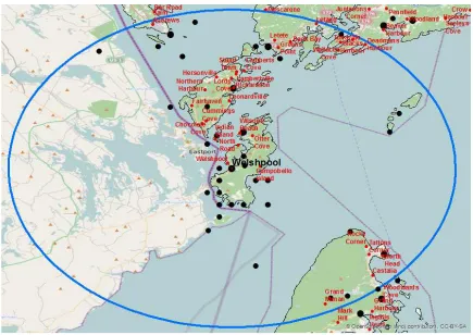
A generous donor has provided $1 million (USD) for to set up a broadcast antenna to share the Tintamarre 2014 celebration in Saint John with the widest possible audience. She has specified that the antenna be located on a mountain top within 150 miles of the city and that the mountain top could be in Canada or the United States. The goal for this task is to identify the tallest mountain within 150 miles of Saint John and find the closest airport to that mountain.
7.2.1 Finding Saint John - Fuzzy Search
1. The analyst accidently types in 'Saint Johns' and NGA feature designation PPL and an exact match to locate all the Saint Johns in New Brunswick. There are no Saint Johns in New Brunswick, (We could also try St. John or St. Johns to see if these might work as well)
2. The analyst turns on the fuzzy search with 'Saint Johns' and finds that there is a Saint John.
3. The analyst sees that there is only one Saint John in New Brunswick.
4. The analyst takes the coordinates from Saint John and uses them in the next process.
7.2.2 Tallest Mountain within 150 Miles of Saint John – Radial Search
1. The analyst initiates a 150 mile radial search query from Saint John (-66.095316, 45.230798) using the USGS feature type 'Summit' for features.
The client application will show the user the feature types in the NGA gazetteer which match the USGS feature type 'Summit.' In other words,. the client is supposed to show the semantic mappings to the user as part of the query process, i.e., USGS feature type 'Summit' brings up NGA feature designations, Mountain, Hill, Knob, etc. Exposing the user to the semantic mapping is a key new capability in Testbed-10.
3. The analyst will intersect the query result with elevation data to obtain elevations for all the mountains.
4. The application will sort the results based on the elevation values in descending order, from highest to lowest. The tallest summit should be Mount Katahdin in Maine.
7.2.3 Closest Airport to Highest Mountain – Near Search
1. The analyst issues a near query from the location of the tallest mountain on NGA feature type Airfield (AIRF) to see what USGS feature types will be returned. 2. Curious with the result, the analyst changes the query to the USGS feature type
'Airport' to see what NGA features will be returned. He sees that this is more comprehensive and decides to use the USGS term 'Airport' in the query.
3. The analyst views the results in a table and on a map. The closest airport should be Millinocket Seaplane Base.
8 Virtual Global Gazetteer Query Requirements
8.1 Introduction
OGC Testbed 10 demonstrated a client that allows a user to formulate a query that includes the name, a name string filter for the name, a feature description, country, and a spatial constraint. The results are returned in tabular form, with the ability to search for additional results if a subset of the search results is returned by the query. By using gazetteer conflation (cf. clause 12) and linking (cf. clause 11), access to additional attribute and spatial information, e.g. through geonames.org, is enabled for returned results.
8.2 Query by Name
Text searching operators are based on the OGC Filter Encoding Standard (cf. OGC 09-026r1) and support “starts with”, “ends with”, “sub-string containment” and “fuzzy string matching” searches.
All Testbed-10 servers used the UTF-8 character set for handing diacritics, native scripts, special characters, etc.
The user can enter a name, including diacritics, and select how the name is utilized in the query. Options include:
Starts With (Saint *) Ends with (* John) Contains (John)
Fuzzy Match (St. John ~ Saint John)
In our demo scenario, the source gazetteer is assumed to be WFS-G from NGA, which for the simple name query would return all stored features matching the above criteria. Given Saint John could not only be a town, but as well a church or a place name, the query should be narrowed down with one or more of the filters described in the following sub-clauses, which have been partly adapted from OGC 12-104, with an added discussion on the implication of the extended query filter requirements in Testbed-10.
8.2.1 Starts with
The “Starts with” operator is meant to match text strings that begin with a specified sequence of characters. For example, someone searching for records that contain the text string “Boston” might instead search for any string that starts with “Bost” in order to case a wider search net. The existing Filter Encoding standard already supports this type of predicate using the PropertyIsLike operator. The following example illustrates the use of the PropertyIsLike operator to match strings that start with a specified prefix:
8.2.2 Ends with
The “Ends with” operator is meant to match test string that ends with a specified sequence of characters. For example, someone searching for records that contain the text string “New York” might instead search for any string that ends with “York”. Like the “Start with” operator, the existing Filter Encoding standard already supports this type of predicate using the PropertyIsLike operator. The following example illustrates the use of the PropertyIsLike operator to match strings that end with a specified suffix:
<fes:Filter
This sub-clause defines a set of operators that extend the capabilities of OpenGIS’s Filter Encoding 2.0 Standard (cf. OGC 09-026r1) to support advanced text searching capabilities. The operators are a standalone extension package that makes use of the extension points defined in the Filter Encoding 2.0 Standard (cf. 7.12.3, OGC 09-026r1). This namespace for the advanced text search extension shall be:
http://www.opengis.net/fes/2.0/advstr/1.0
8.2.3.1 Introduction
8.2.3.2 XML encoding
The following schema fragment defines the PropertyContains operator. <xsd:element name="PropertyContains"
type="advstr:PropertyContainsType" substitutionGroup="fes:extensionOps"/> <xsd:complexType name="PropertyContainsType">
<xsd:complexContent>
<xsd:extension base="fes:ExtensionOpsType"> <xsd:sequence>
<xsd:complexType name="NearType"> <xsd:simpleContent>
<xsd:extension base="xsd:string">
<xsd:attribute name="within" type="xsd:positiveInteger"/> </xsd:extension>
</xsd:simpleContent> </xsd:complexType>
<xsd:element name="SearchTerms" type="advstr:SearchTermsType" substitutionGroup="fes:expression"/>
<xsd:complexType name="SearchTermsType"> <xsd:simpleContent>
<xsd:attribute name="escapeChar" type="xsd:string" use="optional" default="\"/>
<xsd:attribute name="matchCase" type="xsd:boolean" use="optional" default="false"/> </xsd:extension>
8.2.3.3 KVP encoding
The following table defines the KVP parameters that encoding the PropertyContains operator:
Parameter O/M Default
Value
Description
VALUEREFERENCE M A reference to a value to be tested by the
operator. This can be the name of a property or an XPath expression pointing to a
sub-field of a complex property.
SEARCHTERM M A string containing the search terms to be
tested.
NEARTERM O If performing a proximity search, the value of
this parameter is the proximal term.
WITHIN O If performing a proximity search, the value of
this parameter defines the distance to be searched (e.g. WITHIN=10 specified that the NEARTERM should exist within 10 words of the SEARCHTERM)
ANDCHAR O & The character used in the searchTerm
parameter to indicate the logical AND connector
ORCHAR O | The character used in the searchTerm
parameter to indicate the logical OR connector
NOTCHAR O ! The character used in the searchTerm
parameter to indicate the locical NOT connector
EQCHAR O = The character used in the searchTerm
parameter to indicate that two search terms may be considered equivalent
ESCAPECHAR O \ The character used in the searchTerm
parameter to suspect the meaning of the andChar, orChar, notChar, eqChar and escapeChar and simply interpret them as characters that are part of the search terms
MATCHCASE O FALSE A boolean indicating whether search terms
8.2.3.4 Parameter discussion
The ValueReference parameter shall reference a value to be tested (cf. OGC 09-026r1, clause 7.4.1).
The SearchTerms parameter contains one or more logically combined search terms that the value being tested shall/may contain. By default the value being tested must contain all listed terms in order for the PropertyContains operator to evaluate to true. In other words, the default logical connection between listed search terms is AND. The logical connection between search terms may be modified using the andChar, orChar, notChar and eqChar parameters. Each parameter defines the character that represents the corresponding logical operator. The defaults are andChar=”&”, orChar=”|”, notChar=”!” and eqChar=”=”. Parentheses may be used to group terms together. The escapeChar may be used to suspect the meaning of the special andChar, orChar, notChar, eqChar and escapeChar characters and simply interpret them as being part of the search terms.
Example: The value being tested must contain the terms “cat” AND “dog” OR the term “fish”.
<SearchTerms>(cat dog) | fish</SearchTerms>
The NearTerm parameter is used to specify a search term for proximity searching. The “within” parameter defines the search distance.
Example: Search for the term “Common” with 2 words of the term “Boston”. <PropertyContains>
<ValueReference>alternativeGeographicIdentifier</ValueReference> <SearchTerms>Boston</SearchTerms>
<NearTerm within=”2”>Common</NearTerm> <PropertyContains>
8.2.4 Fuzzy string matching
8.2.4.1 Introduction
Fuzzy string match operators, unlike regular string matching operators, evaluate how “well” or to what extent two string match. This level of wellness is expressed as a percentage. For example, “string1” is a 86% match to “string2”. Fuzzy string match operators can, for example, be used to allow meaningful searches to be executed with search terms that are misspelt.
8.2.4.2 XML encoding
The following XML Schema fragment defines the XML encoding for the PropertyMatches operator.
<xsd:element name="PropertyMatches" type="advstr:PropertyMatchesType"
substitutionGroup="fes:extensionOps"/> <xsd:complexType name="PropertyMatchesType">
<xsd:complexContent>
<xsd:extension base="fes:ExtensionOpsType"> <xsd:sequence>
<xsd:element ref="fes:expression"
minOccurs="2" maxOccurs="2"/> </xsd:sequence>
<xsd:attribute name="method" type="advstr:MatchMethodType" use="optional" default="levenshtein"/> </xsd:extension>
</xsd:complexContent> </xsd:complexType>
<xsd:element name="MatchString" type="advstr:MatchStringType" substitutionGroup="fes:expression"/>
<xsd:complexType name="MatchStringType"> <xsd:simpleContent>
<xsd:extension base="xsd:string">
<xsd:attribute name="strength" type="advstr:PerCent" use="optional" default="100"/>
</xsd:extension> </xsd:simpleContent> </xsd:complexType>
<xsd:simpleType name="PerCent">
<xsd:restriction base="xsd:positiveInteger"> <xsd:minInclusive value="1"/>
<xsd:maxInclusive value="100"/> </xsd:restriction>
</xsd:simpleType>
8.2.4.3 KVP encoding
The following table defines the KVP encoding for the PropertyMatches operator:
Parameter O/M Default
Value
Description
VALUEREFERENCE M A reference to a value to be tested by the
operator. This can be the name of a property or an XPath expression pointing to a
sub-field of a complex property.
MATCHSTRING M A string containing the search term to be
matched.
STRENGTH O 100 A number between 1 and 100 indicating the
minimum matching strength. A value of 100 indicates that the two argument must be identical. A value of 90% means that the operator will evaluate to TRUE if the two arguments are at least a 90% match. METHOD O levenshtien The method to use to compute the strength of the match.
8.2.4.4 Parameter discussion
The mandatory ValueReference parameter shall reference a value to be tested (cf. OGC 09-026r1, clause 7.4.1).
The mandatory MatchString parameter shall contain the value against which the value referenced using the ValueReference parameter shall be tested.
The optional method parameter is used to identify the algorithm that shall be used to evaluate the reference value and the match string.
All servers shall implement the Levenshtein algorithm (cf. http://www.levenshtein.net) and the Jaro-Winkler algorithm (cf.
http://en.wikipedia.org/wiki/Jaro%E2%80%93Winkler_distance).
Whereas in the previous testbed the fuzzy matching capability was provided through a jaro-winkler distance calculation, in this current testbed the fuzzy matching was implemented through a Levenshtein distance calculation.
The optional strength parameter is used to indicate a matching threshold beyond which the PropertyMatches operator shall evaluate to true. The value of strength parameter shall be a value between 1 and 100 with 100 indicating that the arguments must be identical in order for the PropertyMatches operator evaluates to true. Lower values allow for increasingly “fuzzier” matches.
Example: The following example searches for alternative geographic identifiers that are a 90% match for the string “Albeon” using the Jaro-Winkler algorithm.
<ogc:PropertyMatches method="jaro-winkler">
<ogc:PropertyName>alternativeGeographicIdentifier</ogc:PropertyName> <ogc:MatchString strength=”90”>Albeon</ogc:MatchString>
</ogc:PropertyMatches>
This predicate would, for example, match the string "Ablion".
The successful use of the PropertyMatches operator confirmed its utility and potential role in future WFS-G usage. It is therefore recommended that this operator be included in future revisions of OGC standards.
8.3 Query by Feature Description
8.3.1.1 Introduction
The user should be able to filter queries by the feature description (also known as the feature designation). This description could reflect the terminology of either agency, i.e., the user should be able to query on USGS feature descriptions or NGA feature designations. These should be expanded to common language descriptions rather than codes. As an example, a user should be able to select USGS feature descriptions and pick a term like ‘summit.’ This term would access information from related NGA feature classes, such as ‘mountain’, ‘hill’, ‘peak’, ‘rock’, etc. The user should also be able to filter features based on the use of NGA terms. In this case, picking a term like ‘hill’ would return USGS ‘summit’ features. These mappings should be displayed to the user on the query form.
For the demo scenario the delegation would look for a town, i.e. a populated place. The selection in the client thus applies a source gazetteer description filter, narrowing the query down to features complying to the following NGA LocationTypes:
8.3.1.2 XML encoding
The PropertyIsSemanticallyRelatedTo operator, proposed in OWS-9, was reused for Testbed-10. A minor modification was made in constraining queries by placetype rather than URI. This modification was made because the URIs (hyperlinks in SI_LocationType instances) used in Testbed-10 were found to be different from those used OWS-9; the placetypes however remain the same between different implementations.
<ogc:PropertyIsSemanticallyRelatedTo>
<ogc:PropertyName>iso19112:locationType/@xlink:title</ogc:PropertyName>
<ogc:Literal>locale</ogc:Literal>
</ogc:PropertyIsSemanticallyRelatedTo>
8.3.1.3 KVP encoding
The PropertyIsSemanticallyRelatedTo operator is used within the Filter submitted with the request.
8.3.1.4 Parameter discussion
The PropertyIsSemanticallyRelatedTo operator, as used in Testbed-10, accepts only two parameters (an XPath through the PropertyName parameter and a locationType name through Literal property.
8.4 Query by Country
8.4.1.1 Introduction
Since queries for features on a global scale not only return a fast amount of (most likely unwanted) results, but also come with a performance limitations, the user would be expected to narrow down a search by selecting the country of interest first. Country names are expanded to common language descriptions rather than codes.
8.5 Query by Spatial Constraint
The user should be able to filter the query using a bounding box, radial search, or near query that will sort the results from closest to furthest away from a given coordinate.
8.5.1 Radial search
OGC web services offer a number of approaches for implementing radial search, e.g.: the intersection of a location property with a CircleByCenterPoint geometry,
which was applied in OWS-9 and is described in OGC 12-104, or
use of the DWithin operator which allows features to be tested within a distance of a geometry (typically a point).
In the case of radial search, the effect of these two approaches is the same as they both test for intersection with a buffer around a point. It should be noted however, that DWithin has the potential to support geometries other than a point.
Testbed-10 examined both approaches and found that the NGA, USGS and NB WFS-Gs supported radial search through DWithin, meaning that requests could be cascaded within minimal transformation. In contrast, since neither of the services supported CircleByCentrePoint, the transformation of a CircleByCentrePoint geometry into a supported geometry such as a polygon would be required to support the alternative approach for implementing radial search.
Based on this experience, it is recommended that WFS-G shall by default support radial search through DWithin operators.
8.5.1.1 Introduction
8.5.2 Nearest Neighbour
8.5.2.1 Introduction
A nearest neighbour search finds objects near a centre point and orders the features in the response according to the distance from that search point. Unlike a centre-point-radius search, a nearest neighbour search will always return a result – regardless of how far away from the centre point the closest object is – as long as the database is not empty.
8.5.2.2 Implementation
The nearest neighbor search relies on a spatial index being available in order to calculate distances to all locations in the supporting databases. This meant that the virtual global gazetteer would have to rely on the NGA WFS-G (based on WFS 1.1) and the USGS/NB WFS-G (based on WFS 2.0). The testbed participants found that currently the Filter 2.0 standard prevents WFS 2.0 from being backwards compatible with WFS 1.1. This is discussed in the Testbed-10 CCI Profile Interoperability Engineering Report (OGC 14-021), clause 10. Consequently, the nearest neighbour algorithm was implemented on the client application.
8.5.2.3 KVP encoding
A stored query with the name “Nearest Neighbour By Location Type” and assigned the identifier “urn:cw:def:query:OGC-WFS::NearestNeighbours:ByLocationTypeName” can be implemented to provide the nearest neighbor capability on WFS-Gs supplying the virtual global gazetteer. The following table defines the parameters for this stored query:
Parameter Name Expected Type
Lat Number
Lon Number
srsName URI
The following is an example invocation of the nearest neighbour stored query that returns the nearest objects of type “Mountain”:
http://www.opengeospatial.org/server?service=WFS&version=2.0&request=GetFeature&
storedQuery_Id=urn:cw:def:query:OGC-WFS::NearestNeighbours:ByLocationTypeName&locationTypeName=mountain&lat=45 .288278&lon=-66.062351&srsName=urn:ogc:def:crs:EPSG::4326&count=10
8.5.2.4 Parameter discussion
All parameters are mandatory.
8.5.3 Bounding-box search
8.5.3.1 Introduction
A bounding-box (BBOX) search finds objects within a coordinate rectangle. It applies to all feature types listed in the request.
8.5.3.2 XML encoding
The BBOX operator was used for this capability, for example: <ogc:BBOX>
<ogc:PropertyName>iso19112:position</ogc:PropertyName> <gml:Envelope srsName="urn:ogc:def:crs:EPSG::4326">
<gml:lowerCorner>44.8755955883576 -66.8650672925836</gml:lowerCorner>
<gml:upperCorner>45.6188750089766 -65.3198488862554</gml:upperCorner>
</gml:Envelope> </ogc:BBOX>
8.5.3.3 KVP encoding
The following table defines the KVP encoding for the BBox operator: Parameter Name Expected Type
LowerCorner longitude Number
LowerCorner latitude Number
UpperCorner longitude Number
UpperCorner latitude Number
8.5.3.4 Parameter discussion
9 Architecture Enhancements
Based on the feedback from OWS-9, the basic architecture underlying the Virtual Global Gazetteer shall be improved and where necessary developed.
9.1 Cascading WFS accessing NGA and USGS Gazetteer
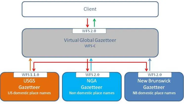
As in OWS-9, the Virtual Global Gazetteer has been implemented as a cascading WFS (WFS-C). The WFS-C basically behaves towards a client like a standard WFS. Instead of holding data itself, it cascades the client request to two or more subsequent WFS, which provide the actual data requested.
The major benefit of this approach is integrated access to distributed feature data sets, without the need for a client to explicitly know the underlying service endpoints and capabilities.
9.2 Architecture
The architecture of the Virtual Global Gazetteer is illustrated in figure 1 below:
Figure 2 - Virtual Global Gazetteer Architecture
On the client side the Virtual Global Gazetteer behaves like any WFS 2.0 service, as specified in OGC 09-025r1.
The initial getCapabilities request from the client is cascaded down to the USGS and NGA WFS. To accommodate the different WFS capabilities, the Virtual Global Gazetteer creates a compatibility matrix from the cascaded responses. Based on this, subsequent requests can be re-written according to each gazetteers capabilities (cf. clause 9.1.2).
The USGS and NGA servers offer the GMLSFL1 encoding of the ISO 19112 model (cf. clause 6).
9.3 WFS-C Implementation Issues
This section of the document discuses a number of technical issues associated with the implementation and deployment of the WFS-C approach. Where applicable, reappearing issues encountered in OWS-9 have been adapted from OGC 12-104.
9.3.1 Compatibility matrix
A WFS-C reports a capabilities document which is based on the capabilities of the servers that it is cascading.
In general, a WFS-C will cascade child servers that support different versions of the WFS standard and that implement different sets of capabilities from the version of the standard they support. For example, the USGS Gazetteer WFS 2.0 supports a number of spatial operators while the NGA Gazetteer WFS 1.1.0 only supports the BBOX spatial operator. For this reason, a WFS-C must internally create a compatibility matrix so that it has the necessary information to report a merged capabilities document and has the necessary information to rewrite input requests to suit each cascaded WFS.
9.3.2 Merging capabilities document
An important function that a WFS-C must perform is to decide how to merge the capabilities documents reported by all cascading servers in order to report a single capabilities document for the WFS-C.
During the OWS-9 test bed a “minimum common capabilities” approach and a “maximum capabilities” approach were tested. Testbed-10 followed the OWS-9 approach, which is discussed in OGC 12-104.
9.3.3 maxFeatures/count handling
1. The cascading server applies the maxFeatures value to the entire result set – that is assembled from the responses from each cascaded server.
2. The cascading server passes along the maxFeatures value to each cascaded server and then concatenates all the results returning N x maxFeatures features in the response (where N is the number of cascaded servers).
3. The cascading server processes the responses from each server in a round-robin manner, including one feature in the response for each cascaded server response, until maxFeatures is reached.
The problem with approach (1) is that in most cases only records from the first cascaded server will be included in the response. Approach (2) violates the WFS standard because it actually returns more features than the client requested. Approach (3) seems to strike an acceptable balance between standard compliance and including records from each cascaded server in the response.
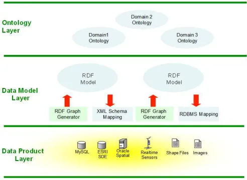
The approach used by Image Matters to semantically-enabled existing data stores (Geonames stored in a PostGIS database) and services (USGS, NGA, Geobase WFS-Gs) was explored during Testbed-10 and can be considered as an alternative to the syntactic approach used in OWS9. The Semantic mapping components provided a GeoSPARQL interface on top of existing data APIs (SQL and OGC Query). The benefit of this approach was to provide a unified knowledge representation (based on RDF Model), query language and access protocol (GeoSPARQL) to the data and leverage the existing infrastructure already in place.
9.4 Performance and effort
The Virtual Global Gazetteer should be designed to access and deliver results from the complete NGA and USGS Gazeteer services.
9.4.1 Performance Tests
The previous testbed did not collect performance metrics. However, one clear difference is that the NGA WFS-G in OWS-9 only included data covering Mexico. In contrast, the NGA WFS-G in Testbed-10 covered the entire Globe (apart from the US). For each semantic query, the Virtual Global Gazetteer transforms a query and sends it to the different WFS-Gs providing data; thereafter, each WFS-G returns data to the Virtual Global Gazetteer which then returns compiles the responses and returns the compiled responses to the client application. The response times of the Virtual Global Gazetteer therefore include the response times of the services that supply data to the Virtual Global Gazetteer. Running a semantic query through the Virtual Global Gazetteer WFS-G, in Testbed-10 and with responses encoded in GML, resulted in the following response times.
9.4.2 Caching options
Areas where caching could help to reduce the response times include:
Caching of data retrieved from the other WFS-Gs such as the NGA, USGS and New Brunswick services.
Caching of semantic mappings retrieved from the SPARQL Server.
It should be noted however that the low response times (indicating quick responses), imply that there is little value in caching data retrieved from other WFS-Gs.
9.4.3 Fault Tolerance
Due to lack of capabilities and potential problems in service, the addition of fault tolerant functionality needs to be addressed to assure consistent service and provide the user with an understanding of the results returned.
2. or only the exception from a subsequent server is handed on to the client, along inline with the valid responses from other servers cascaded servers.
Since option 1 isn’t a desirable approach, the WFS 2.0 implementation of the Virtual Global Gazetteer in Testbed-10 followed option 2. Exceptions are reported to the client by assembling a response from the successful responses of the cascaded WFSs and including any exceptions inline in the response document:
Exceptions for WFS 1.1.0 requests are included in-line with the response as XML comments since the WFS 1.1.0 standard does not address the issue of generating in-line exception reports.
10 Semantic Mediation in Testbed-10
10.1 Introduction
Semantic mediation is an approach to overcome differences between servers and the data they offer, such as differences in CRS support, response formats, or semantics. This has been addressed in OWS-9 (cf. OGC 12-103r3).
Since WFS 2.0 is a superset of WFS 1.1, many WFS2.0 requests can be directly rewritten to a WFS 1.1 request, as long as common capabilities are concerned and implementations follow the specifications. It might only require a change in the version number, whilst the request syntax can be kept intact. Where a WFS 2.0 requests a capability which isn’t available from a WFS 1.1, this would cause an exception (cf. 9.7.3) that needs to be handled. However, a number of requests can also rewritten based on the capability matrix (cf. 9.1).
10.2 Testbed-10 Approach
Figure 4 - Request transformation process
10.2.1 Request transformation
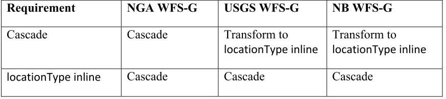
The WFS-G Best Practice only specifies an application schema for GML 3.1.1. Whereas the NGA gazetteer services was found to support GML 3.1.1, the USGS and NB gazetteer services were found to support GML 3.2.1 and not GML 3.1.1. The impact of this difference was that requests received by the mediator could not be simply forwarded to all three foundation gazetteer services without modification to specify the GML version supported by the target gazetteer service. The mediator was therefore configured to check the GML version specified in a request and then depending on the target gazetteer service, the mediator either replaced or retained the GML version specified. The following table explains how the request is transformed within the request transformation process presented earlier in this section:
Requirement NGA WFS-G USGS WFS-G NB WFS-G
GML 3.1.1 Cascade Transform to
GML 3.2.1
Transform to GML 3.2.1 GML 3.2.1 Transform to
GML 3.1.1
Cascade Cascade
10.2.2 XPath references
Another issue encountered was that WFS allows a feature property to contain its value as content encoded inline or to reference its value through a simple XLink. It was observed that the USGS and NB services supported queries on properties in line, whereas the NGA service supported queries on properties both inline and by reference. This made it necessary for the mediator to check the XPath expression used to name the locationType and then depending on the target gazetteer service specified, the mediator either replaced or retained the XPath reference with an appropriate one.
Requirement NGA WFS-G USGS WFS-G NB WFS-G
Cascade Cascade Transform to
locationType inline Transform to locationType inline
10.2.3 PropertyIsSemanticallyRelatedTo Operator
In OWS-9, an operator was designed to support the use of semantic filters in WFS queries. The new operator, named PropertyIsSemanticallyRelatedTo allowed a client application to filter features by property values that are semantically related to the search term.
Whereas in OWS-9 the location type hyperlinks were used to select relevant mappings, in Testbed-10 the actual place names were used.
The reason for the change of approach is that the WFS-G services used in the current testbed adopted a different URI scheme from the services used in the previous testbed. The impact is that an update is required to the PropertyIsSemanticallyRelatedTo operator proposed in the previous testbed to allow it to accept a choice of hyperlinks or literal values.
10.3 Implementation issues
10.3.1 Stored queries
Stored queries retrieve data based on a predefined filtering. These are supported by WFS 2.0, but not by WFS 1.0.
An example is the Nearest Neighbour capability, which was implemented in the USGS WFS 2.0 server as a stored query. Whilst the WFS-C recognizes the capability for the USGS service, it cannot rewrite that stored query to be executed on the NGA V1.1 WFS. The issue is further discussed in the Testbed-10 CCI Profile Engineering Report, clause 10.
10.3.2 Advanced filtering operators
The advanced text search operators (cf. 7.1.4) implemented were implemented as an extension in the USGS gazetteer but not the NGA gazetteer. There is no efficient or reliable way that a request containing these operators can be rewritten so that it can be executed on the NGA server.
10.4 Conclusions and future work requirements
taxonomies of feature types in gazetteers can be aligned using purely SKOS constructs (exactMatch, narrowerMatch,..). There is nothing wrong with that and it is the right approach to take. This is a very common mechanism used in the library community. However, in the more general use case, transformations from one ontology to another require a more complex process that involves the use of rules. The hydro WG is trying to tackle this approach. The ImageMatters in Testbed-10 approach for semantic mapping is very similar to the one used by TopQuadrant with SpinMap <
http://composing-the-semantic-web.blogspot.com/2011/04/spinmap-sparql-based-ontology-mapping.html>. SPARQL and declarative mapping expressed in RDF are used to perform class and property mapping.
A recommendation is to standardize the vocabulary for expressing semantic mapping, so it can be shared and be processed by machine. There is no consensus in the industry today how to proceed with semantic mediation. Some advocate the use of Rule Interchange Format (RIF), others advocate the use of a unified logic language, others the use of SPARQL. Time will tell what is the best approach.
OGC is tackling a problem that is a very advanced use case while it has not addressed the most fundamental problem, which is how to publish geographic linked data and define the foundational geospatial ontologies (a task we are addressing during this testbed). Hence the following recommendations for future requirements should be considered in subsequent testbeds and future standardisation work:
10.4.1 Standardization of the core geospatial ontologies
Standardize the core geospatial ontologies, so people can use them to expressed their geographic data as linked data.
10.4.2 Best practices to publish geospatial linked data
Define set of best practices to publish geospatial linked data (use of GeoSPARQL, RDF, OWL, Linked Data Best practices)
10.4.3 Cleanup of the GeoSPARQL standard