REMOTE SENSING APPLICATION FOR MANGROVE MAPPING IN THE ELLEMBELLE DISTRICT IN GHANA
By
JUSTICE CAMILLUS MENSAH
THE
UNIVERSITY
of Rhode Island
GRADUATE SCHOOL OF OCEANOGRAPHY
Coastal Resources
This publication is available electronically on the Coastal Resources Center’s website at http://www.crc.uri.edu
For more information on the Integrated Coastal and Fisheries Governance project, contact: Coastal Resources Center, University of Rhode Island, Narragansett Bay Campus, 220 South Ferry Road, Narragansett, Rhode Island 02882, USA. Brian
Crawford, Director International Programs at [email protected]; Tel: 401-874-6224; Fax: 401-874-6920.
For additional information on partner activities: WorldFish: http://www.worldfishcenter.org Friends of the Nation: http://www.fonghana.org Hen Mpoano: http://www.henmpoano.org Sustainametrix: http://www.sustainametrix.com
Citation: Mensah, J. (2013) Remote Sensing Application for Mangrove Mapping in the
Ellembelle District in Ghana. USAID Integrated Coastal and Fisheries Governance
Program for the Western Region of Ghana. Narragansett, RI: Coastal Resources Center, Graduate School of Oceanography, University of Rhode Island. 24 pp.
A Major Paper Submitted In Partial Fulfillment Of The Requirements For The Degree Of Master Of Environmental Science And Management, University Of Rhode Island, May 11, 2013
Major paper advisors: Dr. YQ Wang and Dr. P. V. August. MESM track: remote sensing and spatial analysis.
Disclaimer: This publication is made possible by the generous support of the American
people through the United States Agency for International Development (USAID)/Ghana. The contents of this report are the responsibility of the Integrated Coastal and Fisheries Governance (ICFG) Program and do not necessarily reflect the views of the United States Government. Associate Cooperative Agreement No. 641-A-00-09-00036-00 for
“Integrated Coastal and Fisheries Governance (ICFG) Program for the Western Region of Ghana,” under the Leader with Associates Award No. EPP-A-00-04-00014-00.
Cover Photo: Mangroves
Contents
List of Figures ... iii
ABSTRACT ... iv
ACKNOWLEDGEMENT ... v
BACKGROUND/INTRODUCTION ... 1
MANGROVES IN GHANA ... 2
STATEMENT OF PROBLEM ... 3
REMOTE SENSING OF MANGROVE FORESTS ... 3
OBJECTIVES ... 4
MATERIALS AND METHODS ... 5
Study Area ... 5
Data ... 6
Remote sensing data ... 6
Ancillary data ... 6
Survey data ... 6
Data Processing and Analysis ... 8
The current mangrove map ... 8
Past mangrove maps ... 8
Accuracy Assessment ... 10
RESULTS AND DISCUSSION ... 10
The current spatial dimension of mangroves ... 10
Accuracy Assessment ... 11
Past Mangrove extent ... 13
Areas potentially at risk ... 14
CONCLUSIONS ... 15
List of Figures
Figure 1 Map of the study area showing surrounding communities and the hydrology ... 5 Figure 2 The three datasets that were used for the study ... 7 Figure 3 Result of the summary statistics of the seven Landsat TM bands ... 9 Figure 4 A visual comparison of the Landsat TM image; a) the original image with bands
4,3,2 displayed in RGB, b) the PCA ... 9 Figure 5 Reference points that were used for assessing the accuracy of the current
mangrove map ... 10 Figure 6 Current (2012) land cover image of the study area showing the four classes ... 11 Figure 7 Result of the accuracy assessment showing the accuracies of the mangrove
ABSTRACT
Despite the immense contributions of mangrove ecosystems through the provisioning, cultural and regulatory ecosystem services they provide, these important ecosystems continue to be exploited the world over. In Ghana, about 24% of the countries
mangroves were lost between 1980 and 2006. Ghana's mangroves continue to reduce in health and coverage, especially in areas outside the five Ramsar designated sites in the country. Moreover, the use of compensatory mechanisms in addressing the exploitation of coastal ecosystems and climate change mitigation is in its nascent stages in Ghana because of the uncertainties in their carbon stock estimates due to uncertainties in their areal extent.
The main objective of this study was to apply remote sensing technology to map the past and present areal extent of mangroves in the Ellembelle district in the western region of Ghana, especially in the face of limited data. Three main remotely sensed data were used in the study: a true color orthorectified digital aerial photo (AP); and two satellite data sources ‐ RapidEye and Landsat Thematic Mapper (TM) imagery. Additional data were acquired through a participatory mapping exercise and a GPS survey. Other ancillary data like an existing land use/ land cover map of the area was used for the mapping.
A hybrid method (combination of supervised and unsupervised classification) was used along with principal components analysis (PCA) spectral transformation technique to produce four land cover classes; mangroves, other vegetation, water body and others (other land cover types). The current mangrove map showed that this ecosystem covers about 450 hectares and comprises three species of pure mangroves: Avicennia
germinans, Conarcarpus erectus and Rhizophora species.
Additionally a combination of GPS ground reference points and randomly generated reference from the sub meter digital AP reported a producer's accuracy of 80.95% and a user's accuracy of 89.47% for mangroves. An overall Kappa statistics of 0.793 was
ACKNOWLEDGEMENT
To God be the Glory great things He has done. I'm grateful to God for this wonderful opportunity to study in the US in the first place. His unfailing love has kept me moving. I also thank my sponsors, the Coastal Resources Center, for this great opportunity to study at URI.
I would like to thank my major paper advisors, Drs. Peter August and YQ Wang for their advice and all their help throughout my graduate program. I really appreciate your time, patience, guidance, support and encouragement.
I want to say a special thank you to all the CRC staff (Ghana and Rhode Island) for your help. Thanks to Donald Robadue, Steve Olsen, Brian Crawford, Kimberly Kaine, Pam Rubinoff and Hilary Stevens, Mark Fenn, Kofi Agbogah, Godfred Asiedu, Stephen
Kankam, Justice Inkoom and Augustine Odamtey for all your encouragement and support.
I would also like to thank all the good people in the Environmental Data Center and the Laboratory for Terrestrial Remote Sensing. I want to appreciate Charles LaBash, Galen Scott, Glenn Archetto, Christopher Damon, John Clark and Mike Bradley for their
assistance and encouragements.
Thanks to Emmanuel Abeashie Mensah of University of Cape Coast, Ghana for his enormous support, guidance, assistance and encouragement throughout this research, I really appreciate it.
BACKGROUND/INTRODUCTION
Mangroves are an assemblage of tropical and sub‐tropical halophytes (i.e., salt tolerant) woody plants which grow in loose wet soils of brackish‐to‐saline estuaries and shorelines in the tropics and sub‐tropics (Aheto et al, 2011; Heumann, 2011). This unique forest type was reported to have covered up to 75% of the world's tropical coastlines (Vaiphasa et al, 2006). The total global mangrove coverage is estimated to be about 180,000 km2, distributed in 112 countries and territories in the tropics (Aheto et al, 2011).
The ecological and economic benefits of mangroves are well established. Globally, they are known to be the most productive and unique coastal ecosystems that support a wide range of goods and services (Aheto et al, 2011). The ecosystem goods and services that mangroves provide include protecting the coastline from tidal waves and storm surges; acting as biological filters in polluted coastal areas; supporting aquatic food‐chains; and shielding a large number of juvenile aquatic organisms (Vaiphasa et al, 2006).
These ecosystem goods and services are estimated to be worth about US $10,000 per hectare per year or about US $180 billion globally (Heumann 2011b). The value of mangroves has been recognized by many governmental and non‐governmental organizations in recent years as well as international agencies. International programs, such as the Ramsar Convention on Wetlands and the Kyoto Protocol for instance,
underscore the importance of immediate protection measures and conservation activities to prevent the further loss of mangroves (Kuenzer et al, 2011).
Mangrove forest ecosystems have received greater recognition over the past few years for their ability to sequester green house gases. This is because recent climate change mitigation efforts have focused on the reduction of green house gases especially carbon dioxide (CO2) through the conservation and restoration of natural systems
recognized as efficient carbon sinks (Trumper et al, 2009). For instance, the
International Panel on Climate Change (IPCC) has predicted that to mitigate about 12– 15% of projected CO2 emissions from fossil fuel burning by 2050, a global program that involves reduced deforestation, enhanced natural regeneration of tropical forests and worldwide re‐afforestation will be required to sequester
60–87 Gt of atmospheric carbon for that period (Trumper et al, 2009). It has also been reported that blue carbon sinks, which comprises vegetated coastal habitats like
mangrove forests, salt‐ marshes and seagrass meadows, rank amongst the most intense carbon sinks in the biosphere (Nellerman et al, 2009; Duarte et al, 2005). Donato et al (2011) have also established that mangroves are among the most carbon‐rich forests in the tropics. Mangrove ecosystems therefore require immediate attention.
has been estimated that the world had lost a total of about 35% of the area once covered by mangroves since the 1940s, and these important ecosystems are still reducing at a current loss rates of about 1 to 3% per year (Valiela et al, 2001). Major threats to mangroves include logging for fuel and timber; land conversion to aquaculture, primarily shrimp ponds; coastal development for shipping; and the direct and indirect effects of urban development including fresh water diversions (Heumann 2011b).
MANGROVES IN GHANA
Mangroves cover about 137 km2 (UNEP, 2007), constituting approximately 0.2% of the 81,342
km2 of total forest area in Ghana (Gordon and Ayivor, 2003). The mangroves in Ghana are limited to very narrow, non‐continuous coastal lagoons and estuaries, notably from the Ivory Coast border to the Cape Three Points; and in the east, bordering the fringes of the lower reaches and delta of the Volta River (UNEP, 2007; Spalding et al, 2010; Gordon and Ayivor, 2003).
There are six species of true mangroves in Ghana. These are Acrostichum aureum, Avicennia germinans, Conarcarpus erectus, Laguncularia racemosa, Rhizophora
harrisoni, and Rhizophoran racemosa. Rhizophora racemosa tends to dominate the open lagoons while Avicennia germinans, Conarcarpus erectus, Laguncularia
racemosa and Acrostichum aureum are often associated with closed lagoons with elevated salinity (UNEP, 2007; Ajonina, 2011) Mangroves in Ghana play very important economic and ecological roles in the country, especially in the
surrounding communities. The national economic value for mangrove related harvesting and contribution to marine fisheries alone has been estimated as $600,000 per year (Ajonina, 2011; Gordon et al, 2009). Over the years, mangroves have been exploited by the local populations mostly for wood, and food. People who live in mangrove areas get wood (for fuel, building materials, etc), fish, crabs, snails and oysters either directly from mangrove or its associated environment (Gordon and Ayivor, 2003; Spalding et al, 2010, Ajonina, 2011). Ghana's mangrove ecosystems are known for the associated biodiversity they support. They are well noted for the provision of habitat for high
concentrations of birds, mammals, amphibians, reptiles, fish and inveterate species. They also serve as habitats, sanctuaries and breeding grounds for migratory birds.
Despite the immense contributions of mangrove ecosystems to the local populations and the country as a whole, their health and survival continue to be undermined. Between
1980 and 2006, the country lost about 24% of its mangroves (UNEP, 2007). Some documented threats to mangroves include population increases leading to the over exploitation and the ultimate conversion of mangroves into other land uses, mostly development of urban centers and industry; engineering in the rivers and coasts such as the construction of dams and sea walls; and land‐based sources of marine pollution (UNEP, 2007).
protection has been provided over the years through a number of traditional
management systems. In addition, five Ramsar sites in the central and eastern areas of the country, which include mangrove habitats, have been designated since 1992
(Spalding et al, 2010; UNEP, 2007). These Ramsar sites are managed for sustainable conservation, but they are still exploited (Spalding et al, 2010)
STATEMENT OF PROBLEM
Ghana's mangroves have decreased considerably over the past few decades and continue to diminish at a relatively high rate (Spalding et al, 2010). Mangroves continue to be exploited even in the Ramsar designated sites. This wide‐spread exploitation is more imminent in the western part of the country where none of the many mangrove sites is managed by any formal arrangement. The Ellembelle district of the Western region of Ghana is the home to several hundred square kilometers of coastal
ecosystems including extensive mangrove forests. Mangrove forest consisting of pure and mixed stands of Laguncularia, Rhizophora and Avicennia species can be found in the near shore lagoons and estuarine areas. However, the vulnerability of these
ecosystems, like many other mangrove forest, continues to increase with increasing population and land use change. In light of recent oil discoveries in the off shore areas of the district it is also expected that the west coast in general will become a hub of industrial activities, resulting in social pressures and increased exploitation of mangrove forest and other coastal resources.
The use of compensatory mechanisms in addressing the exploitation of coastal ecosystems is in its nascent stages in Ghana. In the terrestrial environment, climate mitigation mechanisms like the reducing emissions from deforestation and forest degradation (REDD+) has gained some level of acceptance in Ghana. Despite the importance of coastal ecosystems as effective carbon sinks, much has not been done about them and there have been uncertainties in their carbon stock estimates due to uncertainties in their areal extent (Bouillon et al, 2008). However, remote sensing has been recognized to play a crucial role for producing detailed and accurate
characterizations of mangrove, which is an essential component for supporting ecological understanding and management of mangroves.
This study therefore looks at the application of remote sensing technology for mapping the areal extent of mangroves in the Ellembelle district in the western region especially in the face of limited data.
REMOTE SENSING OF MANGROVE FORESTS
change detection; and selection and inventory of aquaculture sites (Green et al., 2000; Vaiphasa et al, 2006).
The remotely sensed data and the techniques that have been used for characterizing mangrove ecosystems have evolved over time, moving from a traditional remote sensing approach to a more advanced one. Traditional approach includes the use of aerial
photography (AP) and some high resolution systems (Heumann, 2011; Green et al, 1998). Aerial photography is sometimes preferred in developing countries because it is most cost effective and more readily accessible. It is very effective over small areas than satellite remote sensing because it can provide fine grain imagery unavailable from satellite remote sensing (Mumby et al., 1999; Heumann, 2011). They can also be essential for the accurate assessment of classification procedures performed on other, lower‐resolution, data (Kuenzer et al, 2011). The most common technique associated with aerial photography has been visual interpretation.
Other traditional mangrove remote sensing applications involve the use of high resolution (multispectral) satellite imagery like Landsat, SPOT and ASTER. Some of the techniques that have been used to detect and delineate mangrove have involved unsupervised and supervised classification techniques, and sometimes a combination of both. Other
techniques include spectral transformations such as principal components analysis (PCA) or Tassel‐Cap Transformation, or spectral vegetation indices such as Normalized
Difference Vegetation Index (NDVI) (Green et al, 1998; Heumann, 2011).
There has been a very rapid advancement in mangrove remote sensing over the past few decades. Development in satellite sensors including very high resolution
multispectral systems such as Quickbird, IKONOS, GeoEye and Worldview‐2; hyperspectral systems like the Hyperion as well as Radar and LiDAR systems have grown in leaps and bounds. Similar advancement in the remote sensing techniques promises detailed and more accurate mangrove mapping at a finer level (Vaiphasa et al, 2006; Heumann, 2011). Some of the advanced techniques are Object‐Based Image Analysis (OBIA), and image texture metrics.
OBJECTIVES
The main objective of this study is to apply remote sensing for mapping the past and current mangrove coverage in the Ellembelle district in Western region of Ghana for monitoring and conservation purposes. The study specifically seeks to:
1. map the current spatial dimension of mangrove forests in the area surrounding the Amanzule river and estuary,
2. make a past land cover map of the same site to detect changes in mangrove extent, and
MATERIALS AND METHODS
Study Area
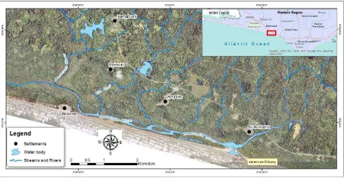
This study was conducted along the Amanzule River in the Ellembelle district, on the south western coastline of Ghana. The study area, hereafter referred to as the Amanzule mangrove site, forms part of the Greater Amanzule Wetland. This wetland is a
community protected area in the Nzema traditional area in the Western region and one of the important wetland ecosystems in the country. The site is located between latitudes 40 56' 20"N and 40 58' 50"N, and between longitudes 20 21' 40"W and 20 27' 20"W and comprises a relatively contiguous mangrove stand along the Amanzule and Ebi rivers. The Amanzule River enters the sea at Azulenloanu, creating the Amanzule estuary. Communities surrounding this mangrove site are Ampaim, Bakanta, Azulenloanu, Nyanzini, and Kamgbunli. The Amanzule mangrove site covers approximately 12 square kilometers.
Figure 1 Map of the study area showing surrounding communities and the hydrology
Despite their immense benefits to the surrounding communities, these forests are
Data
Remote sensing data
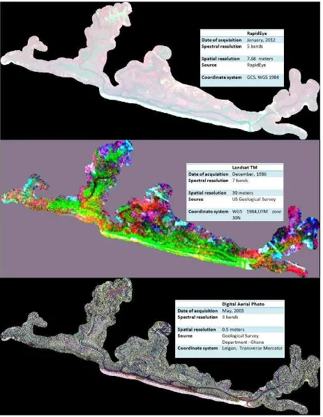
Three main remotely sensed data were used in the study. These were a true color orthorectified digital aerial photo (AP); and two satellite data sources ‐ RapidEye and Landsat Thematic Mapper (TM) imagery. The digital AP was acquired in May 2005 and has a spatial resolution of 0.5 meters. The RapidEye data were acquired on January 2012 and have a spatial resolution of 7.7 meters. The Landsat TM data on the other hand was captured in December 1986 and has a resolution of 30 meters with 7 spectral bands. The characteristics of the two data sets are shown in Figure 1.
Ancillary data
Other ancillary GIS data like shapefiles of the streams and rivers in the study area were used. In addition to the shapefiles was a land cover/ land use (LCLU) map of the coastal zone between Cape Three Points and the Ivory Coast border. This map was made for CRC‐ Ghana by Dr. YQ Wang, Christopher Damon and Glenn Archetto at the Laboratory for Terrestrial Remote Sensing in URI.
Survey data
A GPS survey of mangrove sites and a participatory mapping exercise were conducted at the study site. Both datasets were collected through a series of field visits from June to August, 2012. The period for the field trips coincided with the raining regime of the area, making accessibility to certain parts of the forest very difficult, especially for the GPS mapping.
The participatory mapping was conducted in 2 communities in the study area, Ampaim and Bakanta. It involved elderly men and women who had lived in the community for over 20 years and are exposed to the mangroves either through their occupation or other mangrove related activities. Aside mapping the current and the past mangrove extent, the informants were asked questions bordering on a number of mangrove‐related issues including the benefits the community derive from the mangrove products and the
associated environment; the causes of mangrove degradation in the past; what the current threats to mangroves were; and measures that they believe would help to maintain the mangroves.
It's important to note that these two exercises complemented each other and helped to collect enough data relevant for this study over a relatively short period. In many cases the information on the existence of mangroves from the local informants who were involved in the participatory mapping exercise helped fill up for the extremely inaccessible areas.
Data Processing and Analysis
All the data were geometrical corrected and projected to the Universal Transverse Mercator (UTM) zone 30N (WGS 1984 datum)
The current mangrove map
The 2012 RapidEye image was used for mapping the current mangrove extent of the study area. After stacking the five individual layers, the data were geometrically corrected and reprojected into UTM zone 30N. The area of interest (study area) was then subset. A combination of supervised and unsupervised classification technique was adopted for the thematic information extraction. In the Erdas Imagine environment, an unsupervised classification (using the ISODATA algorithm) was used to extract 10 classes using 6 iterations and a convergence threshold of 0.95. The signature of the unsupervised
classification was saved and modified with additional signatures to train the software for a supervised classification. The maximum likelihood algorithm was used for the supervised classification. The additional signatures used for the supervised classification were based on the GPS points and the result of the participatory mapping. Polygons that were
manually delineated on the digital AP were used to copy to area of interests (AOIs) and used as training samples. In all four thematic classes were mapped; namely
mangroves, other vegetation, settlement, and others (other land cover types).
Past mangrove maps
The statistics of each of the seven spectral bands were analyzed and the correlations of the bands were generated using Envi 4.7 software. The bands were checked for data redundancy by comparing the correlation between individual bands.
The result of the statistical analysis (figure 3) showed high correlation values among
most of the bands, indicating very strong relationship between the brightness values of the bands. Based on the result of the this analysis, a principal component analysis (PCA) was conducted in the Erdas Imagine 2012 software to extract 4 layers that explain most of the variability in the data.
The area of interest was then clipped and made ready for the thematic information extraction. A similar technique for the current mangrove map was used to classify the PCA data. An initial unsupervised classification, followed by a supervised classification
Figure 3 Result of the summary statistics of the seven Landsat TM bands
was used to extract the four classes that were mentioned earlier. However, the additional training signatures, in this case were only based on the result of the participatory mapping.
Accuracy Assessment
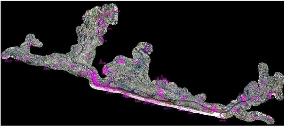
The accuracy of the current mangrove map was conducted with a total of 112 reference points. Out of this total, 67 were points that were collected on the field with GPS during the field visit in June‐August, 2012. The other 50 points were generated using the equalized random sampling methods. The digital AP was very useful for identifying the reference classes of the 50 additional points.
Figure 5 Reference points that were used for assessing the accuracy of the current mangrove map
RESULTS AND DISCUSSION
This section presents the result of the analyses and provides some discussions for each one of them. It is organized to address the three specific objectives of the study.
The current spatial dimension of mangroves
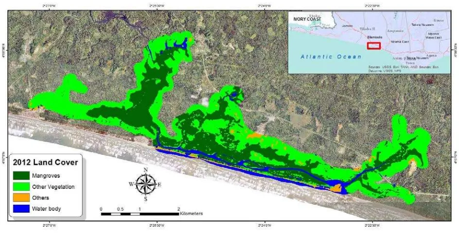
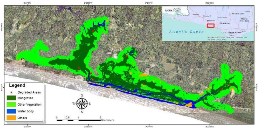
The total subset representing the Amanzule mangrove site covered about 12 km2. Out of this total, approximately 37% (450 hectares) was classified as mangroves (all species). The other land cover types that were extracted included broad categories like water bodies (7%), other vegetation (53%), and others (3%). The water body class comprises all open water features such as rivers, ponds and the ocean. Other
The Amanzule mangrove site comprises relatively healthy contiguous stands mangroves along the Amanzule River and other streams. The mangroves are mostly riverine and basin, with some fringing mangroves along the coastline. The site has three mangrove species: Avicennia germinans, Conarcarpus erectus and Rhizophora species. The
dominant mangrove species is the Rhizophora, which is very established along the rivers and streams. They look very healthy and tall in areas very close to the water (where salinity is relatively low) and where disturbance is minimal. The Rhizophora located in the interior side of the swamps and in drainage depressions are stunted and cutting is predominant.
Small isolated stands of Avicenia germinans are found in areas along the estuary where the salinity of the water is high. In Ampain, however, a more contiguous, relatively
undisturbed stands of Avicenia was found. The Conarcarpus species were only identified in few places in Ampain.
Accuracy Assessment
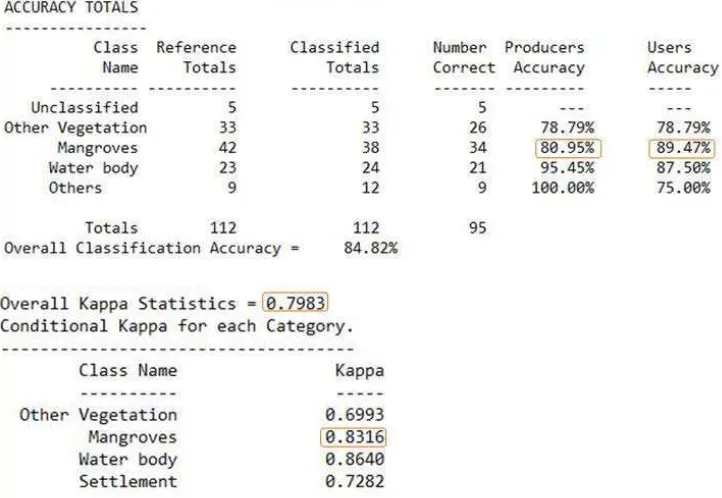
The result of the accuracy assessment that was conducted with ground reference points and randomly generated points produced an overall accuracy of 84.82%. The producer's accuracy and the user's accuracy for the mangroves class were 80.95% and 89.47% respectively. The overall Kappa statistics was 0.7983 and the conditional Kappa for mangrove alone was 0.8316.
Past Mangrove extent
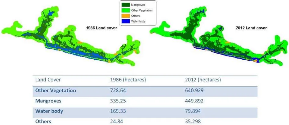
The past land cover map was generated from the 1986 Landsat TM image. Though the general distribution of the various land cover types remained relatively unchanged, the areal extent showed some significant variations. A change analysis was not conducted due to the difference in the resolution; however, a comparison of the changes in area covered over time indicates that there were fewer mangroves along the channels of the rivers and streams in the past.
Figure 8 Past (1986) land cover of the study area showing the four classes
Though this result may have been influenced by the inability of the 30 meter‐resolution Landsat TM image to identify the fringing mangroves (and other vegetation), it actually confirms the perception of the changes in the mangrove coverage by the local folks. According to the participatory mapping exercise and other informal discussions with local informants, the local folks believe that mangroves have actually grown extensively along the rivers and streams, making accessibility difficult in most places. They believe that the
Rhizophora species may eventually close up the water channels.
Areas potentially at risk
The study identified a number of benefits that the mangrove environment as well as the mangrove products themselves offers the surrounding communities. Chiefly among these socioeconomic benefits are the cutting of the mangroves for fuel; building materials for houses; fishing of black tilapia and other fish species; and catching of crabs and other crustaceans and molluscs. Mangroves are the main source of fuel for the local people. In the rainy season (May‐ August), they are often harvested in the interior side of the swamps where mangroves are often stunted. During the dry season however, the roots and branches of the mangroves along the rivers and streams are also cut because accessibility is enhanced. It was also gathered through informal conversations that some local folks use the mangroves for charcoal production.
Though the traditional authority and the residents realize the immense contribution of mangroves through the provisioning, cultural and regulatory ecosystem services they
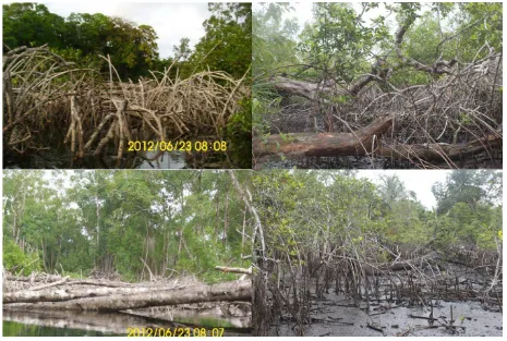
provide, these important ecosystems continues to be exploited. In some areas, human disturbance has resulted in very poor conditions of the mangroves.
CONCLUSIONS
The application of traditional remote sensing approach for mapping mangroves is well documented. Traditional mangrove remote sensing typically involves the use of aerial photography and high resolution satellite image (i.e., spatial resolution between 5 and 100 m) and techniques such as supervised and unsupervised classification of image (Green et al, 1998; Heumann, 2011). This study applied a traditional approach for
characterizing mangrove forests in the Amanzule mangrove site in the Ellembelle district in the western region of Ghana. Three different data sets (digital aerial photograph, a RapidEye image and Landsat TM) were used with different techniques to map the past and mangrove extents of the study site. A hybrid method (combination of
supervised and unsupervised classification) was used along with principal components analysis (PCA) spectral transformation technique (PCA was only used for the 1986 land cover map) to produce four land cover classes; mangroves, other vegetation, water body and others (other land cover types).
Heumann (2011) reports that when traditional data and techniques are used classification accuracies of mangroves classes range from 75% to 90% for producer’s and user’s respectively. In this study a combination of GPS ground reference points and randomly generated reference from a sub meter digital AP reported a producer's accuracy of 80.95% and a user's accuracy of 89.47% for mangroves. The accuracy assessment
was only conducted on the current land cover map. An overall Kappa statistics of 0.793 was recorded. This statistical value expresses the proportionate reduction in error
generated by a classification process, compared with the error of a completely random classification. This implies that the entire classification process avoided about 80% of the errors that a completely random classification would generate.
The following steps represent a relatively robust way of mapping mangroves in
developing areas, especially, when challenges like data availability and time restrictions are inevitable. The current mangrove map may serve as the basis for mangrove monitoring and management in the study area. It could also serve as baseline data for future studies such as biomass estimation, carbon accounting, change analysis,
conservation planning, among others. A similar approach could be used to produce detailed and accurate characterizations of mangrove throughout the country to support ecological understanding and management of mangroves.
Recommendations for future mangrove mapping of this scale could be refined if more GPS reference points distributed evenly across the mapped classes are collected for the accuracy assessment. Additional points would also provide enough information to map the mangrove species. Closely related to this recommendation is the time of year when the GPS survey is conducted. Accessibility is greatly hindered during the raining season (May‐August) therefore, field visits should be planned to take advantage of the drier periods of the year.
REFERENCES
Aheto, D. W., Owusu Aduomih, A., & Obodai, E. A. (2011). Structural parameters and above‐ground biomass of mangrove tree species. Annals of Biological Research, , 2 (3), 504‐514.
Ajonina, G. (2011) Rapid assessment of mangrove status and conditions for use to assess potential for marine payment for ecosystem services in Amanzule and surrounding areas in the western coastal region of Ghana, West Africa. The Marine Ecosystem Services (MARES) Program Forest Trends, 1050
Potomac Street, N.W., Washington D.C. 20007
Bouillon, S., A.V. Borges, E. Castaneda‐Moya, K. Diele, T. Dittmar, N.C. Duke, E. Kristensen, S. Y. Lee, C. Marchand, J.J. Middelburg, V.H. Rivera‐Monroy, T.J. Smith III, and R.R. Twilley. 2008. Mangrove production and carbon sinks: A revision of global Budget estimates. Global Biogeochemical Cycles
22: GB2013, doi:10.1029/2007GB003052
Donato, D. C., Kauffman, B. J., Murdiyarso, D., Kurnianto, S., & Stidham, M. (2011, April 3). Mangroves among the most carbon‐rich forests in the tropics. Nature Geoscience: http://www.nature.com/naturegeoscience
Duarte, C.M., J. Middelburg, and N. Caraco. 2005. Major role of marine vegetation on the
oceanic carbon cycle. Biogeosciences, 2: 1–8.
Green, E. P., Clark, C. D., Mumby, P. J., Edwards, A. J., & Ellis, A. C. (1998). Remote Sensing Techniques for Mangrove Mapping. International Journal of Remote Sensing , 19 (5), 935‐ 956.
Green, E.P., Clark, C.D., Edwards, A.J., 2000. Image classification and Habitat mapping. In: Edwards, A.J. (Ed.), Remote Sensing Handbook for Tropical Coastal Management. UNESCO, Paris, pp. 141–154.
Gordon, C., Ayivor, J. (2003) 'Ghana' in Macintosh, D. J. and Ashton, E.C. (eds) Report on the Africa Regional Workshop on the Sustainable Management of Mangrove Forest
Ecosystems, Washington, DC, ISME/cenTER Aarhus
Gordon, C., Tweneboah, E., Mensah, A.M. and Ayivor, J.S. (2009). The Application of the
Ecosystem Approach to Mangrove management: Lessons for Ghana. Nature & Faune 24: 30‐ 41
Heumann, B. W. (2011). An Object‐Based Classification of Mangroves Using a Hybrid Decision Tree— Support Vector Machine Approach. Remote Sensing , 3, 2440‐2460.
Kuenzer, C., Bluemel, A., Gebhardt, S., Vo Quoc, T., & Dech, S. (2011). Remote Sensing of Mangrove Ecosystems: A Review. Remote Sensing , 3, 878‐928.
Mumby PJ, Green EP, Edwards AJ, and Clark CD (1999). The cost‐effectiveness of remote sensing for tropical coastal resources assessment and management. Journal of Environmental Management 55: 157–166.
Nellemann, C., Corcoran, E., Duarte, C. M., Valdés, L., De Young, C., Fonseca, L., Grimsditch, G. (2009).Blue Carbon. A Rapid Response Assessment. United Nations Environment Programme. Norway: Birkeland Trykkeri AS, Norway.
Spalding, M., Kainuma, M., Collins, L. (2012). World atlas of mangroves. Routledge
Trumper, K., M. Bertzky, B. Dickson, G. van der Heijden, M. Jenkins and P. Manning. 2009. The NaturalFix? The role of ecosystems in climate mitigation. A UNEP rapid response assessment. United Nations Environment Programme, UNEPWCMC, Cambridge, UK, 65 p.
http://www.unep. org/pdf/BioseqRRA_scr.pdf
UNEP (2007) Mangroves of Western and Central Africa. UNEP‐Regional Seas Programme/UNEPWCMC. 92pp
Vaiphasa, C., Skidmore, A. K., & de Boer, W. F. (2006). A post‐classifier for mangrove mapping using ecological data. ISPRS Journal of Photogrammetry & Remote Sensing , 61, 1‐10.
Valiela, I., J.L. Bowen and J.K. Cork. 2001. Mangrove forests: One of the world's
