Mud Volcano and Its Evolution
The term mud volcano refers to topographical expressions of naturally occurring volcano-shaped cone formations created by geologically excreted liquefied sediments and clay-sized fragments, liquids and gases. Ejected materials often are a mud slurry of fine solids suspended in liquids which may include water and hydrocarbon fluids. The bulk of released gases are methane, with some carbon dioxide and nitrogen. Mud volcanoes may be formed by a pressurized mud diapir which breaches the Earth's surface or ocean bottom. Flowing temperatures at the ocean bottom may be as low as freezing point and are associated with the formation of hydrocarbon hydrate deposits. Flowing temperatures can also be hot if associated with volcanic gases and heat escaping from deep magma which can turn groundwater into a hot acidic mixture that chemically changes rock into mud and clay-sized fragments. These mud volcanoes are built by a mixture of hot water and fine sediment that either pours gently from a vent in the ground like a fluid lava flow; or is violently ejected into the air as a lava fountain of escaping mud, volcanic gas, stream and boiling water. Mud volcanoes are most abundant in areas with rapid sedimentation rates, active compressional tectonics, and the generation of hydrocarbons at depth. Typically they are also found in tectonic subduction zones, accretionary wedges, passive margins within deltaic systems and in active hydrothermal areas, collisional tectonic areas, convergent orogenic belts and active fault systems, fault-related folds, and anticline axes. These structures act as preferential pathways for deep formation fluids to reach the surface. (see Pitt and Hutchinson, 1982, Higgins and Saunders, 1974; Guliyiev and Feizullayev, 1998; Milkov, 2000; Dimitrov, 2002; Kopf, 2002, Mazzini, 2009).
The existence of mud volcanoes are controlled by tectonic activity where fluid escapes from areas undergoing complex crustal deformation as a result of transpressional and transtensional tectonics. Collisional plate interactions create abnormal pressure condition and consequently overpressured buildup of deep sedimentary sediment which in turn result in formation of diapirs. Over pressured zones typically are under-compacted sedimentary layers which have lower density than the overlying rock units, and hence have an ability to
flow. They are the product of rapid deposition where the connate water is trapped, unable to escape as the surrounding rock compacts under the lithostatic pressure caused by overlying sedimentary layers. In thick, rapidly deposited shale dominant sedimentary sequence, the low and reduced porosity and permeability due to compaction inhibit the expulsion of water out of the shale. As burial continues, fluid pressure increases in response to the increasing weight of the overburden. This Non-equilibrium compaction is believed to be the dominant mechanism in formation of overpressured sediments. Over pressure however can also result from maturing organic rich predominantly clay sediments which are generating methane and other heavier gases that are still trapped within the sedimentary sequences. The above geological elements that result in diapirsm and mud volcano is often known as !elisional" basin mainly characterized by rapid deposition of thick young sediments, presence of abnormally high formation pressure or overpressures fluids, under-compacted sediments, petroleum generation, compressional setting, high seismicity and occurrence of faults (see Milkov, 2000, and Kholodov, 1983).
Overpressure buildup mechanisms contribute to the brecciation of the deep sedimentary units include for example the dewatering of thick clay-rich sedimentary units, and geochemical reactions in sedimentary units with high temperature gradients are the mechanism for the eruption (Mazzini, 2009). He further suggest that when the subsurface overpressure reaches a threshold depth where the overburden weight is exceeded, fracturing and breaching of the uppermost units occur, sometimes facilitated by external factors such as earthquakes. The upward movement of the mud to surface is due to buoyancy and differential pressure.
Geological structures like faults and anticlines where mud volcanoes are commonly found are easily perturbed by earthquakes as they represent weak regions for the seismic wave#s propagation. This mechanism is well described by Miller et al. (2004) where earthquakes initiating local fluid movements cause fractures that propagate to the surface manifesting with a time delay from the main earthquake. Miller et al. (2004) propose a link between earthquakes, aftershocks, crust/mantle degassing and earthquake-triggered large-scale fluid flow where trapped, high-pressure fluids are released through propagation of coseismic events in the damaged zones created by the mainshock. The resulting disturbance of the gravitational instability triggers the beginning of flow, while the pressure drops and the lower cohesion media is easily fluidized and ultimately vacuumed to the surface through piercement structures which provide the conduits for high pressure mud/fluid and gas release.
The geometry of mud volcanoes is variable. They can be up to a few kilometers in diameter and several hundred meters in height. The main morphological elements of a mud volcano are the crater(s), hummocky periphery mud flows, irregularly shaped terrains, gryphons, and mud lakes or salses. A classification of mud volcanic edifices morphology was proposed by Kholodov, 2002 (in Akhmanov and Mazzini, 2007), these are: (1) !classic" conic volcanic edifice with main crater and mud flow stratification reflecting periodical eruption; (2) Stiff mud neck protrusion, typically due to its high viscosity and hence able to form steep hills; (3) swamp-like area; contrary to no (2), due to its low viscosity the mud spreads over a large area; (4) !collapsed synclinal" depression; and (5) crater muddy lake, is the most abundant type in various mud volcanic areas. It is often that mud volcano morphology shows a combination of the common types described above depending on the viscosity of the mud and the stage of its development.
Mud volcanoes show different cyclic phases of activity, including catastrophic events and periods of relative quiescence characterized by moderate activity. It appears that each eruptive mud volcano has its own period of catastrophic activity, and this period is variable from one volcano to another. The frequency of the eruptions seems essentially controlled by local pressure regime within the sedimentary sequences, while the eruptive mechanism and evolution seem strongly dependent on the state of consolidation and gas content of the fine-grained sediments. This is shown in the compilation of historical data onshore Trinidad as described by Deville and Guerlais (2009).
Venezuela, Colombia and the USSR. The largest number of mud volcanoes is found in the Azerbaijan trend which continues into the Southern Caspian area. In the Indonesian region, mud volcanoes are found on the Islands of Sumatera, Nias, Pagai, Sipora, East Java, East Kalimantan $(Borneo), Rote, Barbar, Aru, Timor, Tanimbar, Yamdena and Papua. They are found in high rate subsidence basins such as Madura-East Java Basin, Kutai Basin, in high seismicity areas such as islands in the Banda Sea and in tectonically complex areas such as Timor and Papua (Sukarna, 2007).
In Papua, Indonesia, mud volcanoes are found along a zone of disruption 400 km long and nearly 100 km wide, occupying hilly terrain with low relief scarred by landslip. They are aligned along structural trends of up to 50 km long and 25 km wide. Individual mud volcanoes range from 3 m to 2.5 km in diameter and reach a maximum height of about 110 m. The ejected mud consist of mud stone containing various shapes and sizes of clasts of older rock assumed as exotic block, which is believed as part of mélange diapirsm (Sukarna, 2007).
Information on mud volcanoes can be used to study the subsurface condition and used as pathfinders of the conditions indicative of subsurface hydrocarbon accumulations in unexplored areas. Gas geochemical data from mud volcanoes can be examined for possible presence of source rocks and their maturity levels. Mud volcanoes are often related to active petroleum systems, especially if the released gas shows a deep thermogenic character. A global data-set of more than 140 onshore mud volcanoes from 12 countries shows that in 76% of cases the gas is thermogenic, with 20% mixed and only 4% purely microbial (Etiope et al., 2009). The thermogenic nature of most of mud volcanoes is related to the relatively high thermal maturity of gas-generating organic-rich rocks. On the other hand, mud volcanoes which release large amounts of CO2, such as those related to magmatic activity,
may not indicate the presence of significant hydrocarbon reservoirs (e.g., Milkov, 2005). Many large onshore hydrocarbon fields were discovered after drilling around mud volcanoes in Europe, the Caspian Basin, Asia and the Caribbean (see Etiope et al, 2009, Link, 1952; Guliyev and Feyzullayev, 1997). Gas origin, composition and secondary post-genetic processes such as secondary methanogenesis which follows anaerobic biodegradation of petroleum or heavy hydrocarbons however, are fundamental factors for determining depth and quality of the related petroleum system, especially in frontier or unexplored areas (see Etiope et al., 2009).
Apart from providing information and evidence of hydrocarbon potential and a working petroleum system, mud volcanoes also provide useful data about the sedimentary section which can be determined by examination of ejected rock fragments incorporated in mud volcano sediments (breccia).
2. Evolution of LUSI Mud volcano
Kusumadinata, 1980 described mud volcanoes as any extrusion on the earth#s surface in the form of clay or mud in which morphology forms a cone in which there is a lake and coupled with the discharge of water and is driven by strong gas flow. Often the release of gas is followed by an explosion and burns, thus the extrusion appearance greatly resembles a magmatic volcano. Apart from this description, Sangiran dome (e.g. Watanabe and Kadar, 1985) and 1936 Dutch maps (see Duyfjes, 1936), very little has been published in journals and scientific papers on mud volcanoes in Western Indonesia, unlike the ones found in Eastern Indonesia such as in Timor (e.g. Barber et al., 1986). In fact, mud volcanism in Indonesia, particularly in East Java is poorly understood. This lack of understanding changed when the LUSI mud volcano (Lumpur !mud"- Sidoarjo), was born as it offered a unique opportunity to study the dynamic development of a mud volcano from its birth on 29th May 2006. In contrast, studies on mud volcanism are typically conducted during the dormant periods between eruptions of already existing mud volcanoes.
The subsequent eruption of LUSI mud volcano has been closely observed and analyzed by the geological community (see Mazzini et al., 2007, 2009; Sunardi et al, 2007; Kadar et al., 2007; Sudarman and Hendrasto, 2007; Kumai and Yamamoto, 2007; Hutasoit, L, 2007; Sumintadireja et al., 2007; Deguchi et al, 2007; Abidin et al. 2007, 2008; Satyana, 2007, 2008; Satyana and Asnidar, 2008; Fukushima, 2009; Mori and Kano, 2009; Hochstein and Sudarman, 2010; Sutaningsih, 2010 etc). Its birth occurred just 2 days after a devastating Yogyakarta earthquake in May 2006. The trigger of LUSI mud volcano is controversial, and has been the center of debate among geoscientists and drilling engineers as it is located near the Banjarpanji-1 oil and gas exploration well drilling that was being drilled. (i.e. Mazzini et al., 2007; Davies et al., 2007, 2008; Manga, 2007; Manga et al., 2009; Tingay et al., 2008, 2010; Sawolo et al., 2008, 2009, 2010; Istadi et al., 2008, 2009). Mazzini proposed that LUSI was caused by fracturing following the May 27th earthquake and accompanied depressurization
of > 100 °C pore fluids from > 1700 m depth. This resulted in the formation of a quasi-hydrothermal system with a geyser-like surface expression and with an activity influenced by the regional seismicity. Davies, on the other hand, suggested that an underground blowout in the Banjarpanji-1 well breached to the surface, thus creating a conduit for the high pressured fluid to escape and created a mud volcano.
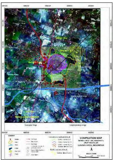
The LUSI mud volcano eruption has continued for over five years, and potentially will continue for many years to come, impacting an ever larger area. The mud eruptions occurred in at least five separate locations forming a NNE&SSW lineament about 200 m away from the Banjarpanji-1 (BJP-1) exploration well in Sidoarjo, approximately 30 km south of Surabaya, East Java, Indonesia (Fig. 2 + 8). The approximately 700 m lineament is contiguous with the Watukosek fault zone (Istadi et al., 2009).
Hot mud erupted at 5,000 m3 a day at the beginning, increased to 50,000 m3/day in the
initial months, then escalated to 125,000 m3/day and reached a high rate of 156,000 m3/day
populated area of Sidoarjo, this could potentially disrupt more than 10,000 families; a major issue to the people, infrastructures and environment. The eruption rate however, has decreased to less than 10,000 m3/day at the time of writing in July 2011; perhaps LUSI is
now entering a new phase, from an eruptive one to a mature and quiescence phase.
Fig. 2. LUSI is located in East Java, about 30 km South of Surabaya (top left). Regional tectonic framework of East Java (top right) shows major NE-SW and E-W major fault trends. Bouguer Gravitymap(processed with 2.65 g/cc density) of East Java (bottom) showing East Java Basin#s depositional centers (blue) which are controlled by the major faults in the area.
2.1 Stratigraphic setting of the LUSI Mud volcano
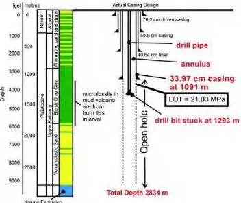
Java Island, located at the southern part of the Sundaland, was formed by rock assemblages associated with an active margin of plate convergence. The island has recorded plate convergence between the Australian plate and the Sundaland continental fragment since Late Cretaceous. Therefore, the island is made up of complex of plutonic-volcanic arcs, accretionary prisms, subduction zones, and related sedimentary rocks (Satyana and Armandita, 2004). The structural history is divided into two phases: a Middle Eocene to Oligocene extensional phase, and a Neogene compressional or inversion phase. Grabens and half-graben structures were developed during the extensional phase, which was followed in the Neogene by compressional deformation with some wrenching. The most recent sedimentation in the East Java Basin occurred during the Late Pliocene to Holocene (3.6&0 Ma), during which time the southern part of the basin (Kendeng depression zone) was affected by north verging thrusts and uplift. The depression developed as a response to the isostatic compensation of the uplift of the southern Oligo-Miocene volcanic arcs. The uplift was accompanied by an influx of volcaniclastic rocks from the southern volcanic arc provenance and were deposited into the depression and causing the depression to subside. Other provenance of the Kendeng Depression is the northern uplifted area that filled the basin with shallow-marine carbonates and marine muds from the Oligocene to the Holocene. Very thick sediments from the two provenances were deposited rapidly into the Kendeng Depression mostly as turbiditic deposits. The East Java geosyncline has thick Tertiary sediments of more than 6000 m (Koesoemadinata, 1980) with an estimated sedimentation rate of 2480 m/ma in the vicinity of LUSI (Kadar et al.,1997). The high sedimentation rates followed by rapid subsidence caused non-equilibrium compaction, and along with the maturation of organic materials resulted in the overpressured sediments within the Kendeng zone (see Willumsen and Schiller, 1994; Schiller et al., 1994). The overpressured sediments were later compressed, become mud diapirs and pierced the overlying sediments in many parts of East Java as mud volcanoes.
Outcrops of sedimentary rocks are very rare as they are covered by alluvial sediements and weathering. Therefore fresh rock outcrops at the rock mine in Karanggandang Village, 28 km to the northwest of the LUSI (Kadar et al, 2007) is important to complete the stratigraphic column of LUSI and the Banjarpanji-1 well.
Fig. 3. Stratigraphy column in BJP <1 well nearby LUSI MV. Density, GR, ROP and DT suggest the presence of overpressured zones. These are probably highly plastic,
undercompacted shale, controlled by rapid sedimentation that trapped water and resulted in an overpressured condition.
The seismic cross-section of this trajectory (figure 4) has a path through three wells, and track from SW to ENE. The wells are Banjarpanji-1 (BJP-1), Tanggulangin-1 (TGA-1) and Porong-1 (PRG-1). At the bottom of the well of Banjarpanji-1 well is a mass of shale that appears mounded and has a large structural dimension. Faulting in the form of positive flower structure between the wrench faults that continuously cut the low velocity intervals, is interpreted as a mud diapir (a depth> 9292 ft or 2834 m).
The structural feature that resembles a flower structure suggests the presence of a wrench fault, thus horizontally sliding components and oblique movements are suggested. The presence of overpressured zones probably consists of highly plastic, undercompacted shale. On seismic it is correlated with a Low velocity zone, and it is characterized by a chaotic discontinues pattern.
Fig. 4. Seismic section of LUSI & Banjarpanji-1 & Tanggulangin-1 & Porong-1 & Porong
collapse structure. The Porong collapse structure located approximately 7 km from LUSI is a paleo mud volcano where subsidence is evident and the multiple faults present likely served as conduits for the mudflow. Similarly, the multiple faults near the BJP-1 well (200 m from LUSI) may have been reactivated and served as conduit for the mud eruptions and escaping gas, hence the appearance of gas bubbles along fault lines.
2.2 Controversy on the trigger
The trigger of the LUSI mud volcano is controversial because of its location and time of birth. The insinuating factors include:
1. The surface location of LUSI is approximately 200 meters away from an exploration well, the Banjarpanji well (Davies et al., 2007, 2008 and 2009). This suggests a possible connection between the drilling of the well and LUSI.
2. A major 6.4 Richter scale magnitude Yogyakarta earthquake rocked Java Island two days earlier (Mazzini et al., 2007 and 2009). This may have reactivated local fault and allowed an overpressured mud to escape to the surface.
4. A number of mud volcanoes in the vicinity of Watukosek fault were reported to suddenly become active at the time of the earthquake (Mazzini et al., 2009)
5. Three mud eruptions that appeared to be in line with the direction of Watukosek Fault (Sawolo et al., 2009)
6. The limited amount of well data available in the public domain especially on the events prior and following the initial eruptions as well as discrepancies over the interpretation of drilling data from the Banjarpanji-1 well (Tingay, M., 2010).
The process of LUSI mud volcano creation is generally believed to be a natural process of an over pressured shale eruption through seismically reactivated faults as conduits (Mazzini et al., 2009). The trigger of the eruption, however, is still a hotly debated issue within the engineering community. Was the creation triggered by a reactivation of nearby Watukosek fault or an underground blowout in Banjarpanji well? A well blowout generally means an uncontrolled flow of formation fluid into a wellbore that travelled up the well to the wellhead. An underground blowout, on the other hand, is when the flow of reservoir fluid does not exit at the wellhead but flows to a low pressured formation in the well and eventually breaches the surface.
Banjarpanji-1 is an exploration well that was drilled in March 2006 in a densely populated part of East Java, in the Sidoarjo region. In May 2006, the well was drilling toward its target, the Kujung limestone. There was little subsurface drilling problems during the drilling process as the well was drilled using a Synthetic Oil Based mud that eliminated much of the problems in the thick overpressured shale section. The schematic of the well is shown in figure 5.
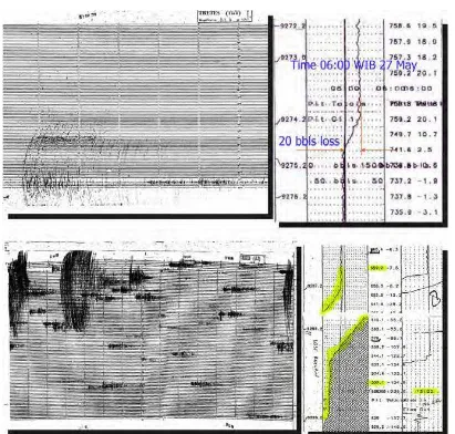
The problem free drilling condition changed in May 27th 2006 when a 6.4 magnitude
earthquake strike near Yogyakarta about 250 km away. Within ten minutes of the earthquake, a 20 bbls of mud loss was observed in the well. Another mud loss occurred following two major aftershocks of 4.8 and 4.6 magnitude where a 130 bbls of drilling mud was lost to the open hole. Drilling mud loss is a serious problem in drilling as the mud hydrostatic pressure is the only mechanism to balance the reservoir pore pressure. Such major mud losses typically occur when drilling mud flows into a newly drilled cavity or a fractured zone or newly formed fractures.
2.3 The underground blowout hypothesis
An underground blowout is not an uncommon problem during well drilling, especially in exploration wells where the geology and reservoir pore pressure is uncertain. If the effective mud weight used to drill the well falls below the pore pressure, a kick (an influx of formation fluid into the well bore) can happen. This kick displaces the heavy drilling mud which reduces the hydrostatic pressure of the mud column and causes an even larger influx of formation fluid. This kick must be killed correctly and a proper hydrostatic pressure restored in order to retain the control of pressure in the well. If the kick is not controlled properly and the well is subjected to a pressure above its critical fracture pressure, then the weakest formation, generally immediately below the casing shoe, may fracture. When there is sufficient force behind the kick, this fracture can propagate upward into shallower formations, or even breach to the surface. This is the mechanism of an underground blowout during drilling of a well.
The possibility that the mud eruption was caused by an underground blowout in the Banjarpanji-1 well was initially suggested by the media immediately after the eruption. There was very little official information of its cause and very little well data was available in the public domain at the time. A similar charge was later iterated in the Davies et al., 2007 and 2008 papers with a pressure analysis that suggested a fracture at the casing shoe. Davies proposed that the well was subjected to a pressure above its critical fracture pressure that caused its weakest formation to fracture. The hydro-fracturing of the formation was propagated and finally it breached to the surface and caused LUSI.
In his papers, Davies proposed a number of operational sequences during the drilling of the Banjarpanji-1 well that caused a kick that leads to the underground blowout. Originally he proposed that the over pressured Kujung limestone was drilled, and this provided the high pressure fluid that caused a kick in the well (Davies et al., 2007). In his later paper (Davies et al., 2008), Davies refined his proposition to the kick was caused by a pressure under-balance in the well since 46 stands of drill pipe were removed without replacing the lost volume due to the removal of the drill pipes. And in his latest discussion paper (Davies et al., 2009) he proposes that the kick was due to a $swabbing# effect. Swabbing means a negative pressure due to an upward movement of drill string.
Davies propositions of Underground Blowout hypothesis is rejected as pressure inside the well is too low to break the formation at the casing shoe of the Banjarpanji-1 well (Nawangsidi, D., 2007). The assumption used by Davies to develop his hypothesis is incorrect as the well is not full of mud but contains water as well as gas; this in effect lower the specific gravity and the hydrostatic pressure in the well. With a lower specific gravity and the published annulus pressure cited by Davies, it is impossible to fracture the casing shoe.
Kujung carbonate was not penetrated by the well, as the calcimetry data during drilling remained low - suggesting that no carbonate formation is drilled, and the well experienced a loss of mud (the opposite of a kick). (ii) The charge that mud was not pumped to compensate for the pulling of drill string out is incorrect. Automatic data recorder showed that mud was pumped appropriately to compensate for the pulling of the drill string. (iii) Analysis on speed when pulling out of the hole and the condition of the wellbore preclude the possibility of swabbing. And finally, (iv) pressure analysis based on the automatic data recorder (Real Time Data-RTD) showed that the pressure exerted on the casing shoe is too low to be able to fracture the formation. It is therefore concluded that the well was intact, no underground blowout occurred in the well and the Banjarpanji well could not have been the trigger of LUSI.
The geologists and drillers in charge of drilling the well have reviewed all the data and cannot support the underground blowout theory. They charge that it is an over simplification to the actual condition (Sawolo et al., 2010). Their approach in analyzing the trigger of LUSI was broader than that of Davies. Instead of relying on limited data and assumptions to fill the missing gap, they collected all available drilling data, logs and cross checked it with other reports to come up with an enriched credible set of data. The various data were assembled to form a mosaic that clearly showed that the well remained intact and an underground blowout in the Banjarpanji-1 well did not occur.
Fig. 6. The controversy on LUSI#s trigger; Sawolo#s view (A) & where the well is intact, the mud flow did not pass through the well. Davies (B), contends that the mud passed through the well, fracturing the casing shoe and triggered the LUSI mud volcano (Sawolo et al., 2010).
The geologists believe that LUSI is more likely to be related to seismic activity. The loss of drilling mud that coincided with the time of the earthquake suggests that the earthquake may have altered the subsurface condition of the region.
The two opposing views of the LUSI trigger as a seismic related event (Sawolo et al) and an underground blowout (Davies et al.,) are shown in figure 6. The scenario proposed by Sawolo is shown in A, where the well is intact and the mud flow did not pass through the well. Davies view is shown in B, where the mud flow passed through the well and fractured the casing shoe.
analysis. Analysis based on limited data can result in a misleading conclusion. It should be understood that the well information on the public domain at the initial stages of the eruption was limited as majority of data was kept confidential by the oil and gas company. It was not until 2009 that Sawolo et al. published for the first time a wide range of well data and observations previously not available in the public domain; this includes important data on formation strength such as the Leak Off Test, Bottom Hole Pressure, minute by minute well pressures and fluid density in the well. The intent of opening the data to the scientific community was that future research on LUSI could be based on actual and credible data in order to minimize assumptions.
The engineering debate on the trigger of LUSI continued until 2010, when Tingay, 2010 published a paper outlining the pros and cons of the competing theories. The paper presented the first balanced overview of the LUSI mud volcano by identifying critical uncertainties of the plumbing system, events prior and following the initial eruptions as well as discrepancies over interpretation of petroleum engineering data from the Banjarpanji-1 well. These uncertainties caused much of the trigger controversy. It is obvious that more studies are needed before LUSI#s actual trigger can be identified.
2.4 The fault reactivation hypothesis
Mud volcanoes are spatially associated with both major and secondary faults within the regional stress field. Surface and subsurface geology shows that faults exist in the region that crosses LUSI areas with the NE-SW and NW-SE direction trends. Faulting in the NE-SW direction is known as the Watukosek fault, an oblique strike-slip fault, whereas the NW-SE trend dextral strike-slip fault pattern is the Siring fault. These faults are partly buried by alluvial sediments.
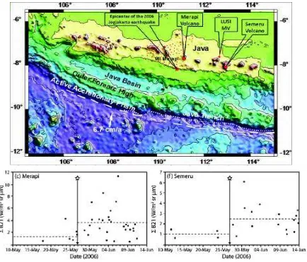
Eruption of mud volcanoes along the fault line is one of several possible subsurface hydrological responses to earthquakes. Manga, however, dismissed the possibility that LUSI was triggered by the Yogyakarta earthquake that occurred two days earlier because of its distance and magnitude (Manga, M. 2007). An empirical plot from past earthquakes in the world shows a distinct relation between the earthquake#s magnitudes to the distances from their epicentres (figure 9).
When the data-point from the Yogyakarta 27th May 2006 earthquake was entered, it shows
that the Yogyakarta earthquake was unlikely to have caused the LUSI mud volcano. It is interesting to note that two past earthquakes that were larger and closer to the area failed to cause a mud volcano in the region. shock at the mud volcano has the intensity of approximately Mercalli 6 and above and at a distance of less than 100 km. However, he also found that even when the intensities exceed the apparent threshold, only a fraction of active volcanoes erupt. This indicates that other factors also play an important role.
Fig. 7. Losses of mud after the Yogyakarta earthquake. The top left picture shows the seismograph reading at Tretes BMG station about 15 km away and the right picture shows the 20 bbls loss seven minutes after the main earthquake. The bottom left showed the aftershocks and the right shows the 130 bbls complete loss of circulation from the wellbore that happened two hours after two aftershocks (Sawolo et al., 2009).
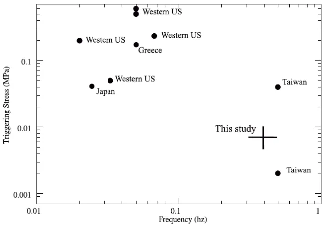
possible. This view has changed especially in the hydrothermal areas. When Mori entered the Yogyakarta earthquake and LUSI data in Fisher#s Dynamic Stress vs. Frequency plot (figure 10), it is located within the value that has triggered mud volcanoesin other regions. Mazzini, one of the very few earth-scientists who conducts field work and data measurement right after the mud eruption, also disagrees with Manga#s conclusion (Mazzini et al., 2007). He cited that eruptions can be affected by earthquakes several thousands of kilometres away and that a delay of few days between the time of the earthquakes and the eruption is not uncommon.
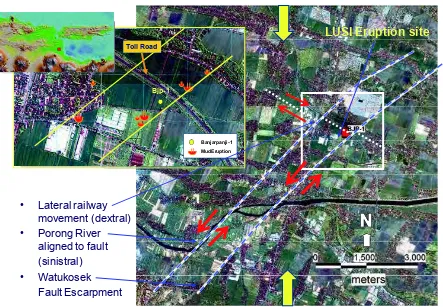
• Lateral railway movement (dextral) • Porong River
aligned to fault (sinistral) • Watukosek
Fault Escarpment
LUSI Eruption site
Bjp-1
Banjarpanji -1
Mud Eruption Toll Road
Fig. 8. Watukosek fault, consisting of 2 parallel faults where the Porong River is aligned along the fault line, while the Watukosek fault escarpment represents the up thrown fault block. LUSI eruption sites are along the Watukosek fault line. The Watukosek fault, striking from the Arjuno volcanic complex, crosses the LUSI mud volcano and extends towards the northeast of Java island.
Fig. 10. Values for dynamic stress and frequency of seismic waves that have triggered small seismic events, compiled by Fisher et al. (2008). The cross shows the estimate for the
Yogyakarta earthquake at LUSI. Source: Mori and Kano, 2009
active vertical movements of mud underneath LUSI, possibly with former eruptions or as a disturbed signal due to the fault that crosses this area. He suggested that the Yogyakarta earthquake ultimately triggered the eruption through the already overpressured subsurface piercement structure. This is supported by a partial loss of well fluid recorded in the Banjarpanji well nearby 10 minutes after the earthquake, and a major loss of well fluid after two major aftershocks (see previous chapter on The Underground Blowout Hypothesis & figure 7). These mud losses, he argued, could be the result of movements along the fault that was reactivated, lost its sealing capacity and become the passageways for overpressured subsurface fluid to escape. These fluids ultimately reached the surface at several locations aligned NE&SW in the Watukosek fault zone direction.
Davies disagreed with Mazzini#s conclusion that the Yogyakarta earthquake reactivated the Watukosek fault and triggered LUSI mud volcano (Davies et al., 2007). He argued that the earthquake was too small and too distant to trigger an eruption when in the recent past, two bigger and closer earthquakes failed to trigger an eruption. He considered the static and dynamic stresses caused by the magnitude 6.4 earthquake too small to trigger LUSI.
Mazzini backed his hypothesis by presenting further field data that support his hypothesis that a strike-slip faulting was the trigger mechanism that released overpressure fluids through already present piercement structures (Mazzini et al., 2009). He presented several observations on the fault reactivation evidence, among others:
x Residents close to the Gunung Anyar, Pulungan, and the Kalang Anyar mud volcanoes, located along the Watukosek fault almost 40 km NE of LUSI (Fig. 1), reported increased venting activity of the mud volcanoes after the Yogyakarta seismic event. Simultaneously, boiling mud suddenly started to erupt in Sidoarjo, later forming the LUSI mud volcano.
fault. The craters were formed during May-early June 2006, but were later covered by the main LUSI mud flows.
x Large fractures several tens of centimetres wide and hundreds of meters long were observed in the proximity of the BJP-1 exploration well with identical NE&SW orientation. However no fluids were observed rising through these fractures, which suggests a shear movement rather than a deformation from focussed fluid flow.
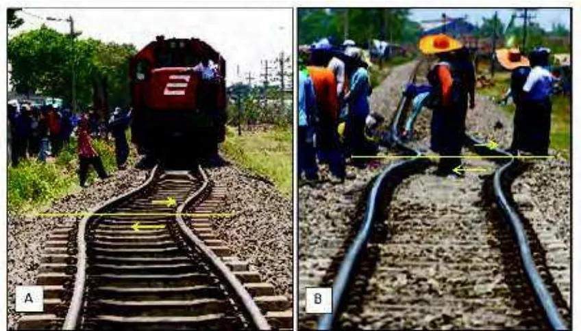
The intersection of the fault with the nearby railway clearly indicates lateral movement. The observed lateral movement recorded at the railway during the first four months was 40& 50 cm. The lateral movement recorded at the neighbouring GPS stations during the same time interval reveals at total displacement of 22 cm (2 cm in July, 10 cm in August, 10 cm in September) (see figure 11). This later displacement was possibly related to the gradual collapse of the LUSI structure. In any case, the difference between these two records shows that an initial 15&20 cm of displacement that must have occurred during the early stages (i.e. end of May&June) related to the Watukosek fault shearing. Since 27th May earthquake, the rails have had to be repaired four times. Two
of these repairs were done within the first three months after the earthquake to remove the bending due to the continuous shearing.
Fig. 11. Shear stress have damaged nearby infrastructures such as the dextral movements of a railway, bursting of a gas pipeline and numerous breakages of water pipelines at the same location further supports displacements along faults. (A)The railway bent to the west of main vent on September 2006. Offsets that occurred approximately 40 cm with orientation direction NW - SE. (B) At the same location, the railway was bent again in October 2009, with an offset of approximately 45 cm. The bending of the railway line is due to fault reactivation that often has differential movements which created shear stress.
He also found seismic sections taken in the 1980s that showed a dome-shaped piercement structure; the most spectacular is the collapse structure in the nearby Porong 1 well (Istadi et al., 2009) (see figure 4). This structure is likely to represent an extinct mud volcano that gradually collapsed around its own vertical feeder channel.
Mazzini further showed shear-induced fluidization mechanism through experiment that a relatively small displacement resembling a fault movement can turn a pressurized sand box model from once sealing layers, to become non-sealing. He demonstrated that the critical fluid pressure required to induce sediment deformation and fluidization is dramatically reduced when strike-slip faulting is active. (see Mazzini et al., 2009).
Fig. 12. Schematic cartoon (not to scale) of a mud volcano appearing along strike-slip faults. The shear zone along the Watukosek fault system and Siring fault that crosses LUSI where a low velocity interval existed before the eruption. Reactivation of the strike-slip fault after the earthquake caused the draining of fluids from the low density units towards the fault zone as the preferential pathway.
2.5 Response to earthquake
Fig. 13. Map of Java, showing the location of the Merapi and Semeru volcanoes. Increases in heat and volume flux occured 3 days after the Yogyakarta earthquake in the Merapi and Semeru Volcanoes. Thermally anomalous pixels detected by MODVOLC showing all band 21 pixel radiance. Source: Harris and Ripepe, 2007.
It was also reported that the magma extrusion rate and the number of pyroclastic flows from the volcano suddenly tripled [Walter et al., 2008]. This change did not last long, and everything was back to normal again after 12 days. This observation suggests that while this magnitude 6.4 earthquake may not able to trigger a new eruption, it is able to change the intensity of an erupting volcano at a long distance (260 km).
The May 2006 earthquake was one of the deadliest earthquakes in Java in historical times. Although it was as a magnitude 6.4, the scale of destruction was unprecedented in the region. The large scale destruction was concentrated in a 10 & 20 km distance along the Opak River Fault where the subsurface lithology consists mainly of soft volcaniclastic lahar deposit (Walters et al., 2007). Walters study suggests that such deposits have the property to amplify the ground motion such that even a relatively small magnitude earthquake could result in large scale destruction.
2006 earthquake changed the static and/or dynamic stresses of the area. Their studies suggest a link between earthquake, changes in subsurface condition and its effect on the volcanic activity.
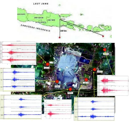
To monitor and record seismic waves around LUSI seismograph installation was carried out at several stations between April and July 2008 (see Figure 14). Seismic waves can be generated by the existing fault activity or by new cracks in the rock layers that had lost their cohesive strength as a result of subsidence around the main eruption vent of LUSI. The microseismic or seismic waves and energy released during crack formation in the rocks is relatively small compared to the energy released by earthquakes.
Microseismic activity recorded by the seismograph network installed around LUSI consists of 6 sensor units, of short period type and broadband seismographs. Each seismograph was
Fig. 14. (A) Epicenter locations of June 1st and 12th 2008 earthquakes located about 240 km
equipped with a digital recorder system that records continuously for 24 hours, and GPS was used as timing marks on the seismic wave data. Data was processed by analyzing the arrival time of the P wave and S wave. The results of =picking= or =reading arrival rate= was analyzed with appropriate software, to determine the source of vibration.
To determine the location of the vibration source or microseismic hypocenter requires seismic wave velocity data at LUSI location. Wave velocity data was obtained from seismic surveys and wells logging data during drilling. Processed results in the form of coordinates of the location of the source of the wave system are plotted in three dimensions, so that the pattern of its occurence can be seen clearly. To facilitate processing, field data which is a mixture of different frequencies and microseismic noise are filtered, so as to identify microseismic events, arrival time, P wave and S wave, maximum amplitude and duration. All data was processed to determine the parameters of microseismic, namely: the timing, location coordinates, depth and magnitude. The results of the data processing are classified into two types of earthquakes, namely: the earthquake which occurred outside LUSI, and those that occurred around LUSI. In this case we will focus on earthquake data that occurred outside the LUSI area to determine earthquake response to changes in temperature, gas flux and behaviour that occur in the main vent.
The ability to detect an earthquake depends on the magnitude of the earthquake, the sensitivity of the sensors (seismometers), and the distance between the hypocenter and the location of the sensors. In general, earthquakes in Indonesia with magnitudes above 5.0 on the Richter scale, will be recorded by almost all seismograph networks in Indonesia. Like the two above mentioned tectonic earthquakes, wave energy can propagate from the source to the sensor around LUSI, with greater strength than the noise level around the sensors.
Table 1. Coordinates of microseismic network stations in the area LUSI.
During the monitoring period two tectonic earthquake occurred outside LUSI. These are: 1. June 1, 2008, Time 15:59:50.2 GMT, the epicenter was located at latitude 9.53o South -
longitude 118.04o East, at a depth of 90 km with a magnitude of 5.5 SR, about 630 km
from LUSI
2. June 12, 2008 At 05:19:55 GMT, the epicenter was located at latitude 9.68o South -
longitude 112.67o East, at a depth of 15 km and magnitude of 5.4 SR, about 240 km from
LUSI.
performed using portable monitoring equipment by BPLS (Sidorajo Mud Mitigation Agency) officers in the field. Measurements from 1 to 20 June 2008 showed a fluctuation LEL, H2S, and temperature at the center of eruption. The peak value of the measurement period occurred on June 12 and 13, 2008, in which all measurement parameters rose sharply, particularly temperature and the concentration of H2S (see figure 15).
Fig. 15. Correlation between LUSI mud volcano activity and earthquakes. Increasing gas expulsion, temperature and mud eruption rates after earthquake are shown in the above graph after the 12th of June 2008 5.5 Mw earthquake. The epicenter was located some 240km
South of LUSI.
The increase in temperature positively correlates with data from the installed seismograph network around LUSI which showed an earthquake occurred approximately 240 km south of LUSI on June 12, 2008. In The case of LUSI, the earthquakes have affected the rheology of fluid in term of permeability, changing the viscosity and the rate of mud eruption, consequently the increased concentration of expelled gases and temperature.
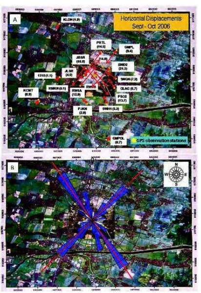
2.6 Horizontal displacement
Geodetic measurements were conducted at the LUSI site to quantify the ongoing deformation processes. The primary data sources were the GPS surveys periodically conducted at monitoring stations to measure vertical and horizontal movements relative to a more stable reference station. Seven GPS survey campaigns were conducted between June 2006 and April 2007. The GPS measurements were conducted at 33 locations using dual-frequency geodetic type receivers over various time intervals. Each measurement lasted from 5 to 7 h. (Istadi et al., 2009).
2.7 Subsidence and uplift
Five years after the mud eruption, the area near LUSI has subsided at a considerable rate. Buildings and houses near the eruption site have completely disappeared under layers of mud. However, in the east and northeast uplift is occurring. To measure both the subsidence and uplift, four survey campaigns were conducted (Table 2):
Start End Points Method
July 2006 March 2007 25 GPS
Dec. 2007 April 2009 30 Total Station
Dec. 2008 Feb. 2011 15 GPS
Dec. 2008 Feb. 2009 5 Level
Table 2. Four survey methods to measure elevation near LUSI MV
Data from these four surveys was used to show the changes in elevation, subsidence and uplift, as well as horizontal movement over time. Subsidence contour maps were created using GIS software by interpolating the measurement data. The results showed an almost concentric pattern shown in Figure 17.
The subsidence started as a crack in the ground that continued to grow and decrease its elevation. The existence of subsidence was evidenced by, among other things, the pattern of ground cracks, tilting of houses, cracking of flyover and bridges, as well as collapsing of buildings. The direction of the cracks varies depending on its location. In the Renokenongo area, southeast of LUSI, the cracks direction is NE- SW, whereas in West Siring area, west of LUSI, the cracks are North-South.
Subsidence and horizontal movements indicate the dynamic geological changes in the area. These movements have caused reactivation of pre-existing faults or newly formed faults. The continued movements along faults would likely result in the emergence of more fractures and gas bubbles (see figures 17 and 18).
Subsidence continues as the mud eruptions progress. The subsidence might result from any combination of ground relaxation due to mudflows, loading due to the weight of mud causing the area to compact, land settlement, geological structural transformation and tectonic activity (Abidin et al., 2007).
Fig. 17. LUSI post eruption map. The subsidence contour is status as of January 2010, constructed by interpolating the measurement data, and was created using GIS software. The contour showed an almost concentric pattern. The area West of the main vent was subsiding faster than other areas.
The map also shows fractures distribution around LUSI. East of the main vent, fractures trend NE - SW, whereas West of the main vent the fracture trend is North-South.
Fig. 18. Photo showing subsidence and collapse of the retaining mud dyke northeast of the LUSI main vent that occurred on 21 May 2008. In some parts, where slumping and
subsidence occurred, local small scale faulting at the edge of subsiding wall occured. The continued subsidence proves very difficult to maintain the dyke.
2.8 InSAR data
InSAR (Interferometric Synthetic Aperture Radar ) is a technique to map ground displacement with a high resolution of up to centimeter-level precision (e.g. Massonnet and Feigl, 1998; Hanssen, 2001). InSAR is effective tool to measure the amount of ground deformation caused by earthquake, volcanic activity has been useful for studying land subsidence associated with ground water movements (e.g. Amelung et al., 1999; Gourmelen et al., 2007), mining (e.g. Carnec and Delacourt, 2000; Deguchi et al., 2007a), and geothermal as well as oil exploitation (e.g. Massonnet et al., 1997; Fielding et al., 1998). The amount and pattern of deformation are shown by a range of colors in the spectrum from red to violet. The computed interferograms are interpreted using an inversion method that combines a boundary element method with a Monte-Carlo inversion algorithm (Fukushima et al., 2005). In LUSI, this technique was used to determine the surface deformation due to the mudflow starting from 19 June 2006 (three weeks after the mud eruption) to 19 February 2007. The measurement was done using PALSAR (Phased-Array L-band SAR) onboard the Japanese Earth observation satellite ALOS. Measurement of land subsidence is possible as the L-band microwave is less affected by vegetation (Deguchi et al., 2007a).
Deguchi et al. (2007a, 2007b) and Abidin et al. (2008) performed a study and measured the ground subsidence temporal changes of deformation obtained by applying time-series analysis to the deformation results extracted by InSAR.
x From 19 June 2006 to 4 July 2006 the subsidence showed an elliptical pattern, suggesting subsidence around the main vent and west of the main vent.
The results from the use of InSAR indicate subsidence has occurred in this area. Four different areas of deformation is suggested, these include areas centered around the main eruption vent; areas to the west-northwest of the main vent; areas to the northeast of main vent; and to the southwest of the main vent. Apart from the areas to the west-northwest which is associated with the deformation due to gas production in Wunut gas field, the other 3 deformation areas follow the regional fault pattern, contiguous to the Watukosek NE-SW fault trend.
The results also demonstrate the progressive subsidence evolution from time to time during the period of measurement. Subsidence in the main eruption area showed the most rapid subsidence rates. The 8-months measurements period showed ellipsoidal subsidence pattern covering an area of approximately 2 x 3 km2 with a long axis trending NE-SW.
Another area to the west-northwest of the main eruption area is also experiencing subsidence. This particular area is within the Wunut gas field which covers approximately 2 X 2.5 km2 with long axis trending NW-SE. This trend corresponds to the regional Siring NW-SE fault trend.
Fig. 19. The interpreted results of InSAR satellite imagery in February 2007 suggest an elliptical subsidence along the NW - SE long axis with a distance of 1-2 km from the main eruption vent, namely in the area around West Siring and Pamotan. In the vicinity of the main mudflow and the eastern regions about 2.5 km northeast of the main eruption, the subsidence occurred elliptical on the N-S long axis.
(figures modified from Deguchi et al, 2007)
ellipsoidal InSAR measurements with regional faults in these areas indicate a correlation between the two. Elipsoidal uplift suggest the long axis trending NNW - SSE is a restraining stepover to offset oblique strike slip fault of the reactivated Watukosek fault.
It is interesting to note that the InSAR measurements found that the deformation diminished after November 2006, only 6 months after the start of the eruption. Interpretation of interferogram for each periodic cycle for the period of May to July 2006 (beginning of eruption) showed more temporal change of deformation compared to the period of November 2006. In contrast, during the period of October - November 2006 field observations indicate increasing intensity of subsidence in the western side of the main vent, particularly in the village of Siring Barat. The main eruption vent and surrounding central area were experiencing most rapid rate of subsidence and continual collapse of the mud retaining dykes. Areas to the E-NE of the main vent were experiencing increases in uplift. The indication of contrasting InSAR measurements could be interpreted as lesser or diminishing effect of initial fault reactivation that triggered LUSI.
Interpretation of interferogram by Deguchi suggesting psudo anomaly in an area to the northeast of the main vent and does not indicate uplift based on conversion to rectangular coordinates (see Deguchi et al, 2007b). Field observation however suggest an uplift has occurred in areas to the east and northeast of the main eruption, in the Renokenongo village and surrounding areas. The uplifted area covers an area of approximately 1 X 1.5 km2 with a long axis trending NNW & SSE.
Fig. 20. The pattern of fractures trending NE -SW in the Village Renokenongo. A section of land on the right hand side of the picture is uplifted (east side) while the left is the
2.9 Fracture orientation
Fractures appeared around LUSI area as a result of loss of cohesion due to ground movement, both vertical and horizontal movements. These fractures were concentrated mainly to the East of the main eruption (Renokenongo village), around the main vent and to the West (Siring Barat village), with displacements of varying degree and magnitude. The fractures follow the sinistral Watukosek NE & SW trend. Juxtaposed with the Watukosek fault reactivation, is the Siring fault movement that trends NW & SE which has dextral strike slip movement. These fractures were caused by reactivation of faults but their orientation pattern are often not apparent due to thick alluvial cover.
Fig. 21. (A). On June 2, 2008 the dyke on the East side of the main vent broke with an
orientation NE-SW. Then on June 8, 2008 the 40 m long dyke collapsed as deep as 6 meters. (B). Fractures on the West Siring village west of the main vent showed an orientation
trending North & South. (C)+(D) an active fault is located west of the main vent and trends North & South.
2.10 Gas bubbles
the number that are still active continually decrease. Presently less than 20 gas bubbles are still active, suggesting LUSI is entering a more stable and less active phase.
Gas bubbles are not continuous; they may burst for several weeks or months then stop and reappear elsewhere. Some gas bubbles appear in straight lines that are contiguous with the fault trends. These gas bubbles are mainly concentrated on the West and South of the main eruption which reflect the existence of subsurface gas accumulation breached by deep fractures. The gas accumulation is believed to be a part of the Wunut gas field flanks with its sealing capacity breached by the reactivated Watukosek faults or newly formed fractures as a result of rapid subsidence in the area.
Fig. 22. (A) + (B) The gas bubble originating from water wells, with tremendous pressure and high content of methane gas. Besides removing water,the bubbles also ejected sand, shell fossils and a bit of mud from the swamp sediments. (C) Gas bubbles along the fracture to the west of the main vent, low pressure and in clusters. (D) a Gryphon located
approximately 400 m west of the main vent.
Gas bubbles around the mud volcano have formed gryphons of around 30 cm in diameter and height of around 40 cm (see figure 22D). The ejected material was mainly methane gas and some water (see figure 22 A and B).
2.11 Source of mud, water, gas and heat
Mud material ejected from the mud volcanoes is believed to have originated from shale layers known as $Bluish Gray# clay of the Upper Kalibeng Formation of Plio-Pleistocene in age. The similarity between the mud and the cutting samples from the nearby well Banjarpanji-1 from a depth of 1220 & 1828 meters is based on the following:
1. The similarity of foraminifera and nanno fossil collection, as well as index fossils containing Globorotalia truncatulinoides and Gephyrocapsa spp. that are Pleistocene in age. Benthos Foram collection shows that the sediment was deposited in the marine environment in the inner to middle neritic zones, ranging from shoreline to a depth of 100 meters.
2. Kerogen composition correlates with the side wall core from Banjarpanji -1 at a depth of 1707 m.
3. Thermal maturity based Vitrinite reflectance (Ro) correlates with cuttings and side wall core samples from Banjarpanji-1 at a depth of 1554-1920 meters.
LUSI muds contain various types of clay including smectite, kaolinite, illite and minor chlorite. It is known that illite minerals form at temperatures between 220 to 320 °C, smectite forms at surface temperatures of up to 180 °C and altered minerals chlorite forms at temperatures between 140 - 340 °C. The XRD analyses carried out on core samples from Banjarpanji-1 imply an intensive progressive smectite-illite transformation with the depth. This suggests that the intersected Upper Kalibeng Formation was exposed to a minimum temperature of 220 °C.
In the initial stages the volume of water in LUSI was very large reaching up to 70% of the total volume of mud with an average salinity of 14,151 ppm NaCl. The lower salinity than sea water suggests dilution. At the time of writing, the liquid composition made up 30% of the total volume. The source of water has been debated by various researchers. Davies et al (2007) states that the water originates from the carbonate Kujung formation, while Mazzini et al (2007) based on geochemical data concluded that the high-pressure water is derived from clay diagenetic dehydration of Upper Kalibeng Formation.
Indonesian Geological Agency, Ministry of Energy and Mineral Resources in 2008 conducted water analysis by using the Oxygen isotope method (ǔ18O) and Deuterium (ǔ D) to determine the magmatic origin of LUSI. Results showed deuterium concentration (ǔD) from -2.7@ to -13.8 @ and Oxygen-18 (ǔ18O) from Q7.59@ up to Q10.11@, and high Chloride content of 12,000 & 17,000 ppm. Based on the above they concluded that the water source of LUSI is associated with igneous rock sourced from magma (Sutaningsih et al., 2010).
Perhaps it is quite impossible to determine the source of water as it could be a mixture of different sources, ie. clay diagenetic dehydration, carbonates, deeper source linked to geothermal, trapped water due to disequilibrium compaction and mixing with shallow meteoric waters. The importance of determining the source is for hydro-geological purposes, in handling the impact of the mud flow, its effect to the environment and contamination to the ground water. If the fluid is old (Tertiary), it is trapped water, whereas, if the water is young (\uaternary), it is likely to be recharged upslope. For the former, naturally, the eruption will stop after a certain time, whereas, for the later condition, the eruption will never stop (Hutasoit, 2007). However, Sunardi et al., 2007 suggested that LUSI will likely stop when hydrostatic pressure equilibrium is reached.
Groundwater samples from LUSI and its surrounding gas bubbles near the main vent have been chemically analyzed for major anions (Cl-, HCO3-, and SO42-) and cations (NaQ, KQ, Ca2Q,
and Mg2Q). The result shows that there is a significant difference in water chemistry between
the main vent and the bubble. The concentration of Cl-, NaQ, Ca2Q, and Mg2Q in the main vent
water are much higher. This suggests that the water may be from different sources, or both are from the same source, but the gas bubble water has been diluted by shallow groundwater. The second case implies that the pressure in the gas bubble areas may be depleting so that shallow groundwater is mixed with deeper sourced water. If the pressure is still high, then flow from the eruption area will contaminate the shallow groundwater. In either case, the ongoing subsidence is also caused by the decreasing pore pressure as the water is discharged to the surface.
The composition of the erupted gas sampled in July in the proximity of the crater showed CO2 contents between 9.9% and 11.3%, CH4 between 83% and 85.4%, and traces of heavier
hydrocarbons. In September, the steam collected from the crater showed a CO2 content up to
from the crater had a lower CO2 content (18.7%). The four gas samples collected during the
September campaign were analysed for Dž13C in CO2 and CH4. The Dž13C values for CO2 and
CH4 vary from ï 14.3@ to ï 18.4@ and from ï 48.6@ to ï 51.8@, respectively (Mazzini et
al., 2007). The relatively low Dž13CCH4 (ï 51.8@) indicates input from biogenic gas mixed with
a thermogenic contribution. The biogenic gas was derived from immature shale layers, probably from the overpressured shale at a depth of 1323-1871 meters, whilst the thermogenic gas was derived from shale layers that are more mature, probably of Eocene age. The CO2 is postulated to come from the dissolved CO2 in the water of the shale layer, at
temperatures above 100 °C and low pressure. The constant presence of H2S since the
beginning of the eruption could also suggest a contribution of deep gas or, most likely, H2S
previously formed at shallow depth in layers rich in SO4 and/or methane or organic matter.
The rapidly varying composition of the erupted gas indicates a complex system of sources and reactions before and during the eruption (Mazzini, 2007).
Temperatures measured from a mud flow within 20 m of the LUSI crater revealed values as high as 97 °C (Mazzini, 2007, 2009). Given the visible water vapor and steam this suggests temperatures above 100 °C. The heat source of the erupted mud is believed to be from a formation at a depth of over 1.7 km where the temperature is over 100 °C. Geothermal gradients of c. 42 and 39 °C/km have been reported in the area. With such a high temperature gradient, LUSI can be viewed as a geo-pressured low temperature geothermal system that discharged hot liquid mud close to its boiling point the first four years of its life (Hochstein and Sudarman, 2010). Hochstein believed that the high temperature gradients are likely due to the low thermal conductivity of the highly porous, liquid saturated reservoir rocks. Mazzini, on the other hand, believed that the high geothermal gradient is due to the close proximity to Mount Arjuno-Welirang (about 40 km), which is part of the Java volcanic arc that formed since the Plio-Pleistocene (Mazzini, 2007, 2009).
Two shallow ground temperature surveys carried out in 2008 showed anomalously low temperatures at 1 m depth (possibly due to a Joule-Thompson effect of rising gases) and liquid mud temperature that varied between 88 and 110 °C with the highest temperatures occurring after a large, distant earthquake. The mud temperature of mud volcanoes is controlled by the gas flux (endothermic gas depressurizing induces a cooling effect), and by the mud flux (mud is a vector for convective heat transfer) Deville and Guerlais (2009).
2.12 Geomorphology of the area
In general, the geomorphology in Porong and the surrounding area is divided into 5 units: Under the volcanic slopes unit, Foot volcanic plateau unit, Cuesta unit, Alluvial plains unit, and Mud volcano unit. The geomorphological units division is based on morphology, the height difference and slope (Desaunettes, 1977).
2.12.1 Under the volcanic slopes unit
2.12.2 Foot volcanic plateau unit
This unit has the morphology of the plains at the foot of Penanggungan mountain or in the medial facies. The unit was formed from the deposition of material surrounding the volcano eruption as laharic. Laharic deposits are found in the form of loose sand and gravel to boulder-sized fragments as products of volcanic eruptions. There is a wide variety of bedding igneous rock fragments to the level of weathering, colors and dimensions.
Lithologic constituents of this unit are fine tuff, sandy tuff, tuff and tuffaceous breccia. The dominant processes in this unit are erosion and sedimentation. The pattern of distribution in this area is a radial pattern.
2.12.3 Cuesta unit
The Cuesta unit is primarily distributed in the southern area of LUSI. The highest point is at an elevation of 150 m at the top of the Watukosek hill. The lowest point is at an elevation of 20 m on the valley of Watukosek. The dominant process in this unit is a tectonic process of faulting, which resulted in shear faults and the down thrown block to the West to form a steep escarpment in the area of Watukosek. This escarpment is known as the Watukosek Escarpment. Lithologic constituents are of andesite breccia, sandstone and tuff. Morphology in the region reflects the existence of Watukosek fault as indicated by the presence of steep slopes on the western escarpment while relatively gentle on the eastern slopes. The pattern of distribution in this unit is trellis pattern.
2.12.4 Alluvial plain unit
Alluvial plains unit make up most of the area and are widely distributed near LUSI. Geomorphological slope is approximately 0 -5%. Lithologic constituents are loose sand deposits, clay, sandy clay.
This geomorphological unit is controlled by alluvial rivers. Geologic processes that act on this unit are erosion, transport and deposition. Lateral erosion took place due to slopes of the mountains to the South causing lateral erosion to be more effective than vertical erosion. In this area there are large rivers namely Porong River which is flowing from West to East that ends up in the Madura Strait. Structural control is clearly visible on the morphology in this area evidenced by the abrupt deflections in the Porong River that follows the fault pattern.
2.12.5 Mud volcano unit
The unit was formed due to discharge of mud from formations below the surface. The morphology is like a low relief hill. The mud volcano Unit is limited by the retaining dykes so that the mud does not spill over into surrounding areas. This unit includes the Village of East Siring, Jatirejo, Tanggulangin Glagaharum, Ketapang and surrounding areas. Lithologically this unit is predominantly the mud itself that contain some fossils.
Fig. 24. Geomorphology map of the Watukosek area.
2.13 Forming of the Crater
The series of photographs in figure 25 below represent the changes through time at the main vent of LUSI Mud Volcano. In a time span of 5 years, LUSI has evolved from a small eruption of steam, hot water and mud to a destructive high rate mud flow, engulfing houses, schools, factories, neighboring villages and caused a large-scale ground deformation, damaged the highways, railroad, pipelines, electrical power lines and others; to presently a much more calm low rate ejection of mud and fluid and occasional intermittent stopping of steam eruption. LUSI evolved through time from a localized kilometre-scale fault zone in 2006 and expanded through pre-existing NE-SW Watukosek fault zone pathways in 2010.
May 2006
LUSI mud volcano on its first day, May 29th, 2006. The mud eruption is
approximately 200 m from the Banjarpanji-1 well location. Initial eruption in the form of mud and hot water and clouds of steam with a discharge rate of less than 5,000 m3/day.
June 2006
In June, the crater had swelled and the discharge has reached approximately 50,000 m3/day, with water temperatures as high as 97 °C.
August 2006
May 2007
In May 2007, retaining walls/dykes were built to prevent the mud from spilling over to the villages and major roads. The height of the dykes encircling the center of
eruption reached approximately 15 m. The average mud flow rate at the time was around 100,000 m3/day.
May 2008
Ring levees/dyke were rebuilt and raised to prevent overflow of mud into the closest villages. Discharge rate was still around 100,000 m3/day with surface water
temperatures remain constant at 97 °C.
February 2009
By February 2009, the ring dyke on the south and north sides are rapidly sinking due to subsidence and are difficult to
maintain despite efforts to continuously pile with soil and gravel.
July 2009
January 2010
The diameter of the main crater at this time is approximately 120 m and flowing
continuously 30-50,000 m3/day. At times instead of a single crater, it changes to two or three points aligned in the direction of the Watukosek fault. The flow is mainly liquid and hot steam. A gently sloping cone is starting to form. The mud covered area is mostly wet, covering 80% of the total area.
January 2011
At this time the mud flow rates and the scale of steam clouds are reduced. The eruption rate has decreased to less than 10,000 m3/day. LUSI is now entering a new phase, from an eruptive one to a mature and quiescence phase. The mud around the main vent is solidifying forming a dome.
May 2011
The mud volcano viewed from the west side. Note the reduced scale of the clouds of steam.
May 2011
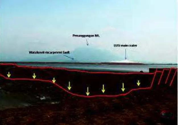
The mud volcano viewed from the north side with the Watukosek escarpment hills and Mt. Penanggungan in the background.
Fig. 26. Map interpretation of the results around the center of LUSI from IKONOS imagery using ERMAPPER Software from 2007 to 2011. The interpretation shows a decrease in the volume of hot mud around the main vent. In 2007, almost all the fluid inside the dyke is above 60oC. By November 2007, the rate of hot mud has begun to diminish. A year later, in