OPERATIONAL SAR DATA PROCESSING IN GIS ENVIRONMENTS
FOR RAPID DISASTER MAPPING
A. Meroni a, T. Bahr b
a
Exelis Visual Information Solutions, Concorezzo, Italy - [email protected]
b
Exelis Visual Information Solutions GmbH, Gilching, Germany - [email protected]
KEY WORDS: Public Safety, Disaster Mapping, Change Detection, SAR, Model, COSMO-SkyMed, SARscape, ArcGIS®, IDL
ABSTRACT:
Having access to SAR data can be highly important and critical especially for disaster mapping. Updating a GIS with contemporary information from SAR data allows to deliver a reliable set of geospatial information to advance civilian operations, e.g. search and rescue missions. Therefore, we present in this paper the operational processing of SAR data within a GIS environment for rapid disaster mapping. This is exemplified by the November 2010 flash flood in the Veneto region, Italy. A series of COSMO-SkyMed acquisitions was processed in ArcGIS® using a single-sensor, multi-mode, multi-temporal approach. The relevant processing steps were combined using the ArcGIS ModelBuilder to create a new model for rapid disaster mapping in ArcGIS, which can be accessed both via a desktop and a server environment.
1. INTRODUCTION
The use of SAR data has become increasingly popular in recent years and in a wide array of industries. Having access to SAR data can be highly important and critical especially for disaster management. SAR imaging offers the great advantage, over its optical counterparts, of not being affected by darkness, meteorological conditions such as clouds, fog, etc., or smoke and dust, frequently associated with disaster zones.
Updating a GIS with contemporary information from SAR data allows to deliver a reliable set of geospatial information to advance civilian operations, e.g. search and rescue missions.
To solve this requirement, we developed an operational processing chain for SAR data within a GIS environment, which can be executed by the responsible operators without SAR expert knowledge.
For this approach we integrated the SARscape modules for ENVI with ArcGIS®, eliminating the need to switch between software packages. Thereby the premier algorithms for SAR image analysis can be directly accessed from ArcGIS desktop and server environments. They allow processing and analyzing SAR data in almost real time and with minimum user interaction. Thus disaster zones, e.g. after severe flooding, can be automatically identified and mapped to support local task forces.
2. CASE STUDY: FLOOD DETECTION WITH
HIGH-RESOLUTION COSMO-SKYMED DATA
The Bacchiglione River burst its banks on Nov. 2nd 2010 after two days of heavy rainfall throughout the northern Italian region (GMES Emergency Response Service (Ed.), 2010). The community of Bovolenta, 22 km SSE of Padova, was covered by several meters of water. People were requested to stay in their homes; several roads, highways sections and railroads had to be closed.
The extent of this flooding is documented by a series of COSMO-SkyMed acquisitions. COSMO-SkyMed is a constellation of four X-band Earth observation satellites, allowing a very frequent coverage, which enables monitoring using a very high temporal resolution.
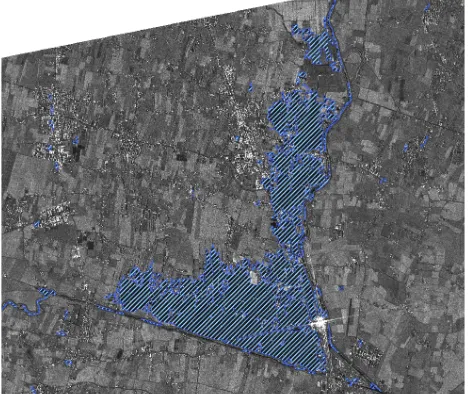
For the present case study we focused on a COSMO-SkyMed-2 image acquired at Nov. 5th 2010, i.e. 3 days after the flash flood (see Figure 1). As a reference we used a COSMO-SkyMed-3 image, acquired at May 9th 2010. Both images were acquired in StripMap mode and ordered as Detected Ground Multi-look (DGM) product (Level 1B) with a GSD of 2.5 m and HH polarization.
Figure 1. COSMO-SkyMed 2, StripMap DGM, Nov. 5th 2010, “Gaussian DE MAP” filtered, DEM-geocoded & calibrated, flooded areas overlaid.
© COSMO-SkyMed™ Product - ASI, 2010. All rights reserved. Distributed by e-GEOS.
International Archives of the Photogrammetry, Remote Sensing and Spatial Information Sciences, Volume XL-1/W1, ISPRS Hannover Workshop 2013, 21 – 24 May 2013, Hannover, Germany
T fin (s Thi tem
Ste Dis red loca assu (sar
Ste DE Geo Dop pre cali law
Ste fina (see com and
4
The Mo in A
F
wo "Be
3
his emp
tep istr educ ocal
ssum arm
tep EM eoc opp reci alib aw (
tep inal see omb nd r
4.
hes od n Ar
Fig
F ork "Be
3.
is d po
ep strib
uce al sum
rma
ep 2 M oco ppl ecis libra
(s
ep 3 al m e F mbi d ra
ese ode Arc
Figu
Fig orkf Bef
3.
s da pora
1 tribu
ce l te mp map
2: ( cod ple isel brat (sar
3: l m Fi bin rast
I
se delB
rcG
igur
igu rkflo
efo
TH
data oral
1: ibut e t tex pti ap
2: (S odin ler sely ratio arm
3: map Fig ine aste
IM
e 3 elBu
cGI
ure
gur flow fore
TH
ata ral a
utio the extu ptio
p S
T (SRT ding er e
ly tion
rm
A ap igu nes
ster-IMP
3 Bui GIS
re 2
ure low ore
TH
ta is l ap
T tion the xtur tion SA
Th SRT ing eq y d ion,
map
A p sh gure es b -t
MP
3 p uild IS, ion-e s tura on
A
The RTM
g is equ de ilde S, b
. A (ste
3. in Im
E
s pr ppr
The -E quat et , wh
p S
sub show
e 1 ban to-v
LE
proc lder , ba
Ar step
. A incl mag
E S
pro proa
he En spe al p reg (Ed
e fi M3 is p atio ete whi SA
ubs ow 1) and ve
LEM
roce er t base
Arc tep
Ar nclu age
SA
roc roac
e s ntr peck l pr rega
Ed.
filt 3v pe tion term
hic A
bse win 1). nd a
vec
EME
ces r to ased
rcG p 2
Arc lud ge"
SAR
oce ach
sin ntro eckl prop gar d.),
filte 3v4 perf ions erm
ich (E
seq ing ). T ar ecto
ME
essi to c ed o
cGI 2)
rcG udin
e":
AR
cess ch
sing trop kle rope
ardi , 2
ltere v4) erfo ns. min ch i
(Ed
equ ng Th arit ctor
MEN
ssin cr d on
GIS ) o
cGI ding
": M
R D
esse h co
ingl opy le per rdin , 20
ered ) w form s. T
ine is Ed.
quen g th Thi rith tor c
MENT
sing crea on
sed con
gle py M e ef
erti ing 201
red wi orm . Th ned is c d.),
uent the his ithm r co
ENT
ng reat
n S
S m f a
IS m g th May
DA
ed u ons
le y M eff
rtie ng 12
d i with rme
Thu ed. hme con
TA
g s ate SA nsis
e i Ma ffec ties g th 12)
im itho ed hus d. carr ), 20
t c e ex
pr eti onv
AT
ste te a SAR
od sin
mod the f 9
TA
usin sist
im ax fect es o the 2).
ima thou ed b us, . T arrie 201
cha ext
pro etic nve
ATI
step e a AR
odel sing
ode e fi
9th
TA
sing istin
ima axim
ct. s of the
ag out d by
s, th Th ried 012
chan xten roc tic, vers
TIO
teps a ne R d
del f ngl
del fina
th 2
TA P
ing ting
ag xim . I of
e f
age ut t by , the This ied
12)
ang tent oce c, s ersi
ION A inal 20
PR
g a ing
age imu In
nge nt o cess , seg rsion
ON AR
s a ew data
for le C
l fo al c 201
RO
form
es a the rig
segm ion.
N O 010
RO orm
ar he n rigo
ma COS
or th cha
10.
OC
sing f 3 goro map ste t by
filte COSM
the han 0. "
CE
ingl 3 s
are a P orou ap tep by
dete the ode
lter SM
the c ang . "A
ES
gle ste
are Po is w
cen of
ge eed rous p lo ep
y f
tec he f cu enta
F T IS
com del
terin MO
e co nge "Af
ESS
le-s step
e f Pos
wa ene of
geo ed usly loc
i fol
ecti e fla cus tati
TH IS
omb el f
ring
com ge d
fte
ESSI
se eps
fi oste way ne d f it
eoc d o
sly oca in follo
ctio flas usto atio
THE
mbi l fo
ng ( -S
om e de fter
SIN
sen ps:
filt ster ay, e do
its
oco of ly a cati incl llow
ion lash stom tion
E
bin for
g (s Sk
mp dete er I
ING
enso
ilter erio y, doe ts s
cod of g
ap atio clu low
on a sh f tom on,
E W
ine or r
(ste Sky
ple etec r Im
NG
nsor
tere rior , th oes st
ode f gr app tion lud win
an h flo miz n, m
W
ned r ra
step kyM
lete tecti Ima
G W
sor,
red ori the es
sta
ded gro pply ons ude
ing
ana floo ize , mo
WO
ed rapi
tep yM
ete ctio ag tati
ed rou plyi ns f des ing
naly lood zed mor
OR
d u apid
p 1 Med
te S tion age
WO atist
us und lyin
fo es
g th
alys od ed
orp
RR
usi id d
1) ed
SA on a ge":
O
mul
w DE res ot istic
usi nd ing for th the
lysi d o d to
rph
RR
usin d di
) an d im
SAR n an e": N
OR
ulti
wit E-M esto t d tica
sin d c ng t r e the he r
sis on to pho
RK
sing dis
lti-ith M stor dep ical
ing co
holo
KF
ng isas
nd ima
R p naly
No
KF
-m
th MA tora depe
al
g con the ever e rad
ge No th olog
FLO
g th sast
d g ag
R pro alys ov
KFL
mo
a AP rati
pen l d
a ontr he R ery ra ada
gen Nov the logy
FLO
the ste
geo age.
proc lysi ov.
FL
od
a AP) atio
end dis
a r ntro Ra ry
rad dar
ene ov.
geoc e.
roce sis . 5t
LO
ode
a G ) tion nd istr
re trol Ran y p adi ar e
nera v. 5
oco
ces (s strib
refe ol p Rang pix diom
eq
erat . 5th
tas filt
W
A ma
cod
essi (st 2
LOW
e, m
Gam filt n of on tribu
efer l po nge ixe iom equa
ates th ask filte
W I
Arc ap
odi
ssin (step
20
W
mu
am ilte
of on ibut
fere poi ge xel
me uat
tes 20 sk lteri
IN
rcG app
din
sing tep 201 ul
mm lter
f th n an utio
ren oint e an el a
etr atio
s th 201 an erin
IN
rcG ppin
ing
ng p 3 010 ulti
ma to the any tion
ence ints and l are etric tion
the 010 and ring
N
GIS ping
g
3). 10.
lti-ma Fil Sk wh (M Fig cha
Th sou sta for wh cha rou
Th scr Ar po pre (Ed
Ex reg det Ar can for
Th exe kn arc ste EN int con the des Se
Ex Do
GM htt Ita
ar v4 Filte Sky whic (Ma Figu chan
The sour stan for A whic chan rout
The scrip ArcG poin prec (Ed.
xe regi dete ArcG can forc
The exec know arch step ENV integ cont the desk Serv
Exe Doc
M http Italy
arm v4.4 ilter kyM
hich ay igur ang
he urc and r A hich
ang utin
he ript rcG int eco d.)
xem gio
tec rcG n b rce
he ecu ow chit eps, NV
tegr nte e A
skt erve
xeli ocu
ME tp:/ aly_
rma .4.0 terin
Me ich ay
ure nge
e u rce ndar Arc ich
nge tine
e th ipt
GIS nt p com .), 2
emp ion, ecti GIS be ces.
e b cut wle hite ps, o
VI gra tem Ar kto ver
elis cum
ES ://w y_2
map 4.00 ring
ed ces: dard rcG h i ge ines
thr t fi
IS t pr omp
20
pli n, I ctio
IS be a .
be utio
led itec s, or I f rate emp Arc top er e
s ume
ES E //ww _27
ap .003
ing
und es: rd rcG is e de es a
hree file IS u pro mpi 201
plif , It ion IS t au
en tion ledg ectu or
fu ated mpo rcG p e r en
V men
S Em ww 27.h
p S
nder : G d fu GIS is c det s an
ree file. us roc pile 012
lifie Ital n a too auto
enef on dge ctur r to fun ted por cGI en ente
Vi enta
Em ww 7.ht
SA ete
erl Ge fun IS. s ca ete and
e t . use oce iled 12)
fied taly an tool utom
efit n b ge ure to unct
d in orar GIS
env nter
Vis ntat
me w. .htm
A (step ima calle
201 T tect
rlyi Geo unc S. T cal tect nd s
to T ser cedu led
2).
ed ly, ana olb tom
fits by in e p o c ncti int rary IS nvir terp
isua tatio
erg w.em
tml
( tep
ag lled 010 Th ectio
lyin eoc ncti . Th alle ecti d sc
too Th er i edur
d I .
d b , w nal lbo mat
its by in pla cre tion into
ry m viro rpri
sual tion
erge .em tion
ing oco ctio Thi lled tion scri
ools his r in
ure ID
by , we alys box
atic
s o y th n a plat crea iona
to a y in mo iron pris
al ion,
rgen me cod tion his ed ion crip
ls his inte
re IDL
y t e lysi ox. tica
of the f latfo
eate nal o an
inf od onm ise.
l I , E
enc erg , 24 odin ona
is t d fr
n a ripte
a is s terf e st ical
of the
fa tfor ate alit any info ode nme se.
In , EN
ncy erge 24.0
d.), ) an are twic an
two ana
alg ding nali s to fro
an pted
are scr erfa sto ally
f th e r fam form te a
lity ny form del men
Inf EN
cy R rgen
.01
, 2 and re i ice and wo anal
algo ng ality
too from ana ted
are scri rfac stor co
5
he N eve s w Thu lly
the re amil
rm ad ity. y o orm el p ent
nfo NV
y Re enc 01.2
20
aly
lgor g & ity oolb
om naly d w
e im ript ace ored cod
5.
N vel wit hus y id
he resp
ili m I addi y. T
oth rma
pr nt a
6
form VI
Res ncy 1.20
201 d g
inte e in th pr
ysi
orit & y fr
lbo m t lys wi
im ipt ce a red ode
5.
Nov elo
ith us d ide
e r espo iliar ID dit Th
the ati pre t an
6.
rm I v
esp cyre .201
012 geo nteg in
the proc ysis
rith & fro box th ysis ith
imp t f e an
d i de
C
ove lope ith s dis
den
re pon iar IDL
itio The her atio
rese and
mat v5
spo yres 013
12. eoc tegr
n th he roce sis (
ithm ra rom ox i the sis ( ith t
ple fil
and in
(E
C
vem ped h S
disa enti
resu ons r G L tion
hes er A ion esen
nd p
R
atio v5.0
pon resp 13.
2. S oco grat the e " ces s (s
hms rad om x is he
s (s th
plem file isas ntifi
esul nsib GI L al ona ese Ar on f ent d pu
RE
tion .0.
ons spo 3.
SA cod rate he "af
ess (ste
ms adi m th is e e S
ste the
lem r d in an Exe
ON
mb a AR aste tifie
ulti sibl IS allo nal se Arc
fr nted pub
RE
ion .0.
nse pon
SAR odi ted e m "aft
ss step
s a diom
the s ex SA step he i
men re inv an xel
ON
ber an R ster fied
ltin ible IS e
llow al to e im rcG from ted
ubl
EF
n
se S onse
ARs din ed ma
fter s se ep 3
ar iom the ext AR tep e in
ent retr invo n I elis
NC
ting le
en low l too
im GI rom d h blis
EFER
S
Se nse.
Rsc ing d in ain ter"
seq p 3)
are me e c xten
Rs p 3 inte
nte etrie
vok ID s
CLU
r 2
env ws tool mag GIS
m he lish
ER
So
Serv se.e
Rsca g ( in ain r" equ 3).
re etr com tend Rsc
3) nter
ted triev
oke IDL s V
LU
20 ope data zon and
p op
nvir s to ols age IS
re her ishe
ERE
Solu
ervi .eu
cap (st n a in m " (N que
p etric com nde sca
) is erac
ed ieve kes
L Vi
LUS
201 pera ata, one nd m
pro oper viro to ls f ge S m
rem ere hed
REN
olut
rvic eu/g
ape (ste a
mo N uen
pro tric
mm ded cap is ract
d in ves es t L .s Vis
USI
010 erat , nes, d m
proc era iron to c
lutio
ice /gm
pe D step a su mod No enc
rov ic c me ed ape is ba
ctiv
in es s th
.sa isua
SIO
0 f ratio , p es, e ma
roce rato onm cu from an
od mot ca d to
ENC
tion
ce ( gme
D ep 2 sub ode ov nces
ovi ca mer d by
e m bas tive
A s th the .sav sual
IO
fla tion pro s, e. ap
ces ator nme cust rom ana ode ote can to u
CE
ions
(E mes
Do p 2)
ub-del ov. es
vide cali erc by m ase ive d
flas iona rov e.g appe
essi tors men
sto m t naly dels tely an o us
CES
ns
Ed es/e
ocu 2) -m el,
. 5 s c
ided alib rcia y t mo sed e da
Arc he e EN
fi l In
NS
lash nal ovi
.g. ped
ssin rs ent tom
th alys els s/en
cum ) o libra cial
the od ed o dat
rcG e p EN file Inf
S
sh al w vide g. a
ed
sing s w nt. omi the lysis ls to ly s be sers
(E
), /en/
um of mod bo
th
con
d b brat
al S the odu d on
ata
cGI pa NV file, Info
h fl wo ided . aft
d to
ng wi M miz he f ode both 2 onv
by ratio l SA e fi dule on ta l
GIS para VI le,
for
flo wor ed after
to
g c with Mo ize e fu is p o u sens e di nver
by tion SAR fil
les n E a lan
IS aram VI/I
, co orm
loo ork d a ter to su
ch itho Mor e s full pr up ense
dis acr
d.),
010 even
enta a si
( h fo 201
erg
y t ion AR filte es EN lang
S u ame I/ID con rma
od rkfl as r se sup
cha hou ore sin ull c pro upda
sed isso acro
,
10. ent
tati sin
(s for 010 rge
th n ( Rsc lter s in ENV
ngu
usi met /IDL
ons ati
d i kflo as sev upp
hain out reo sing ll co roc
dat ed ssol
ros
, 2
0. nt/F
atio ingl (see for 10) ge
thre (s Rsca er t
in NV gua
usin ete DL-nsi atio
in flow s an eve ppo
ain ut S eov ngle com oces
ate d d olv oss
20
t/Fl
tion gle see r th ) i e in
hree ste scap r too
n E VI uag
ing ters
-b sist tion
in t ow an ver por
n i t SA over gle
om cess te a dat lve ss t
201
/Flo
on, step ape tool EN
I p age
ng ers ba istin on ver, le p mpl sse
a data ved s the
012
loo
, S e C Fi he " ima in t
e d ep pe T
ol ENV
pro ge I
g a s f base
ting n S
the for ad re f rt lo
inc AR r, t pro
ple ses
ood
SA CO Fig e "b mag th proc ID
a P fro ased ing
So
he V for c
add flo loc
nclu R
th proc
lem es c
ods-SARs OS igur "be age the
diff 2) Too
ste VI. roce IDL
a Py from sed
g o Solu
e V ch ddit floo oca
clud R e the roce eme
ca GIS Fi fro Ar
. E
-in
AR OSM
ure bef ge e f
iffe 2)
ool step I. ces DL.
Pyt om d e of olut
Ve cha diti ood cal
ude ex he o ces men
can IS w Fina rom Arc
EN
in-Rsc SM
re efo (s fin
ffere ) is
olb tep I. T
essi L.
yth m t en of t utio
ene han ition odin al ta
de exp
op essi ent an w inal om rcG
EN
-sca MO e 2 fore (se fina
eren is lbo p 1 Th ssin .
tho th entr f th tion
net ang iona ding l tas
it xpe ope ssin nt o n b wit ally
it cGI
NV
cap 2), re" (see inal
rent s a box 1), The ing
hon the ntry the ons
eto nge nal ing, task
its pert pen ing t of be ith lly, its GIS
VI
ape
-International Archives of the Photogrammetry, Remote Sensing and Spatial Information Sciences, Volume XL-1/W1, ISPRS Hannover Workshop 2013, 21 – 24 May 2013, Hannover, Germany