Urban Morphology (2015) 19(2), 117–34 © International Seminar on Urban Form, 2015 ISSN 1027–4278
Brenda Case Scheer
College of Architecture and Planning, School of Architecture, University of Utah,
375 South 1530 East, Suite 235, Salt Lake City, Utah 84112, USA.
E- mail: [email protected]
Revised version received 5 November 2015
Abstract. A very broad conceptual diagram of the epistemology of the field of urban morphology is provided as a first step to illustrating the potential connections between different schools of thought. A study of the methods of generating knowledge in this field shows that there are many conceptual and methodological practices that are shared. This shared epistemology can become a basis for comparing the kinds of theories and knowledge generated by different schools of thought. The methods used, the bases for judging their validity, and the scope of enquiries are considered. A systematic definition of the elements that morphologists use for their interpretations is proposed.
Keywords: urban form, epistemology, patterns, evolution, schools of thought
Epistemology is a branch of philosophy that seeks to ascertain how the truth of something is established (Turri, 2014). In the case of urban morphology, the main epistemological frame-work has not been adequately explored. Many of the assertions in this field are inferences that come from expert observation. But much is based on measurements and calculations relating to observed physical phenomena that tend to be accepted as basic as distinct from inferred. What distinguishes justified belief (inferred knowledge) from opinion is a ques-tion that needs to be addressed. Furthermore, it is necessary to be clear about the kind of knowledge that falls within the purview of urban morphology and how that knowledge is acquired.
One of the reasons to explore epistemol-ogy is to help distinguish the commonal-ties of knowledge generation of differ-ent schools of thought. Research within ISUF has been heavily influenced by three schools: the Italian (process typological), the British (historico- geographical), and
the mathematically- oriented space syntax. One can also argue for an emerging school of thought, dominated by North American researchers, which gives greater emphasis to present- day urban landscapes. Similarities of formal analyses between these schools have encouraged the search for common reference points and definitions. While it may not be necessary to bring these schools of thought into a definitive alignment, it is helpful to have points of comparison. It is proposed in this paper that understanding the methods, knowledge generation, and criteria of validity is a promising way of understanding the key differences and commonalities of the varied schools of thought and practice.
its beginning (see, for example, Caniggia and Maffei, 2001; Conzen 1960, 2004; Hillier and Hanson, 1984; Moudon, 1997; Panerai et al., 2004). Excellent summaries of these schools are provided by Whitehand (2001), Larkham (2006), Marzot (2002) and Bafna (2003).
There have been many attempts over the years to unite different conceptions of urban morphology, an early one within the history of ISUF being Anne Vernez Moudon’s article in the first issue of Urban Morphology. She identifies three principles on which urban morphological analysis is based.
1. Urban form is defined by three funda -mental physical elements: buildings and their related open spaces, plots or lots, and streets.
2. Urban form can be understood at different levels of resolution. Commonly, four are recognized, corresponding to the build-ing/lot, the street/block, the city, and the region.
3. Urban form can only be understood his-torically, since the elements of which it is comprised undergo continuous transfor-mation and replacement (Moudon, 1997, p. 7).
Summarizing Whitehand’s perspective, Pinho and Oliveira (2009) offer a few more com-monalities of the two predominant schools – Italian and English: ‘(1) both were concerned with cities as historical phenomena; (2) both conceptualize these phenomena in a manner and to a degree that contrasts with the domi-nant descriptive approaches; (3) both recog-nized cycles in development and focused on periodicities in the creation and adaptation of physical forms; and finally (4) both privileged the predominant forms in the landscape, the huge number of ordinary buildings, rather than the small minority of buildings of archi-tectural distinction.’
Gauthier and Gilliland (2006) provide another framework for classifying various schools of thought about urban form. First, using the conception of Moudon (1997), they distinguish research programmes according to their intentions. They recognize norma-tive – intending to use research as a guide for
future plans ‒ and cognitive – intending to use research to describe urban form and its histori-cal change over time. Following this division, they arrange schools of thought on a contin-uum from autonomous systems to dependent ones, asserting that some schools of thought are more internally directed and others are far more intertwined in relationships with other kinds of analysis.
Karl Kropf (2001, 2009, 2011, 2013, 2014) seeks common ground between various con-ceptions of urban form research, eventually coming down on the built form itself as the potential ‘registration mark’ of different types of urban morphological research (Kropf, 2009). In so doing, he places other poten-tial connections and relationships, including land use, activities and flows, in a different knowledge category. This reduction of the key knowledge of urban morphology to fun-damental built form elements and patterns is a way of paring down the scope of the field. This is important because urban morphology has a tendency to co- opt urban facets that are not strictly formal ‒ using the word ‘formal’ to denote the semi- permanent and definitively located physical elements of a place, includ-ing, for example, the tracks of the streetcar, but not the vehicles.
set of indices of the human activity that cre-ated them’ (Kropf and Malfroy, 2013, p. 129). Moreover, on the subject of autonomy, many concur with Moudon, (1997, p. 9) who states that ‘urban morphology approaches the city as an organism, where the physical world is inseparable from the processes of change to which it is subjected’.
The assumption of this paper is that urban morphology is a distinct field of knowledge that does not have the ambition of achieving a complete description of the complicated dynamics of the city. Rather, it is concerned with describing, defining and theorizing a single segment of urban knowledge (form and formal change) and suggesting how that knowledge is brought into specific relation -ship with other dynamics and conditions in a particular place (including transport, ecol-ogy, social and economic conditions, human behaviour, and political agents). This is not to say that physical form determines other condi-tions, or that physical form is a direct resultant of these forces. Rather, in Moudon’s words, the challenge of urban morphology ‘is to dem-onstrate the common ways in which cities are built and transformed and to illustrate how the principles of change work in many different contexts’ (Moudon, 1997, p. 9).
The first part of this paper is a framework of epistemology encompassing how mor-phologists develop knowledge, the scope of their knowledge, and how the knowledge is validated. These modes of knowledge seek to discover what morphologists do and how they know what they know. In the second part of the paper, the epistemological framework is used to elaborate on topics, particularly the organization of data, where morphologists might find common ground.
This epistemology is entirely based on a conception of urban morphology as cogni-tive knowledge as distinct from presump-tion. In the Italian school and in the work of those employing space syntax, the intention of the work is often very strongly related to design or prescription. However, the analysis and observations of these researchers forms a basis of knowledge apart from their design work. In the process of developing design or
other action, cognitive study is or should be the first step (Moudon, 1992).
Epistemologically, all the urban morphol-ogy schools of thought share certain methods of acquiring knowledge, analysing it, and val-idating it. These are (1) collection of formal data about the study area; (2) recognition of common patterns in the study area and across study areas; (3) developing and testing theo-ries of change; and (4) linking the results of the physical analysis to conditions not directly related to urban form (hereafter non- formal conditions).
Data collection as basic knowledge
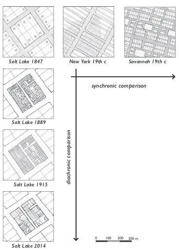
As Kropf (2009) suggests, one way in which urban morphology is distinguished from other kinds of urban analyses, is the starting point of acquiring formal urban data. The researcher starts by gathering formal data, for example in contemporary and historical maps, sur-veys, field measurements, photographs, and documentary records. The data used in urban morphology are substantially measurable or mathematically derived from measurements or co- ordinates of built form, and thus for the most part objective. Formal data have scale, are associated with a particular date and a particular study area, and can be located geo-graphically. There are large amounts of data for any area under study and, depending on the scale of inquiry, might include density of built form, size or segment length of fea-tures, street widths, and location of footpaths and plot boundaries. For buildings the data frequently include descriptions of materials, plans and dates of construction. For some studies, data include topography, elevation, slope, and location of waterways. The data are always intended to be studied in com-parison with one another. Viewing the same place in different time periods (diachronic), and different places in the same time period (synchronic) are widely employed compari-sons (Caniggia and Maffei, 2001, Coehlo and Forma Urbis Lab, 2014) (Figure 1).
Some researchers (for example those employ-ing space syntax) rely primarily on a figure- ground map or a tracing of street segments (Bafna, 2003). While all urban morphologists collect data, not all collect the same type of data. The type of data collected is one of the
differences between the schools. Urban mor-phologists are far more inclusive of data and have greater agreement about what constitute the important elements than most architects writing about urban form. Architects may only use a figure- ground map, and/or neglect
Figure 1. Comparative framework for urban morphological data collection. For comparison, data in urban morphology are collected both
diachronically and synchronically, at the same scale.
GLDFKU
RQLFFRPSDULVRQ
V\QFKURQLFFRPSDULVRQ
6DOW/DNH6DOW/DNH
6DOW/DNH
6DOW/DNH
1HZ<RUNWKF 6DYDQQDKWKF
any focus on time- series comparison. (see, for example, Jacobs, 1993; Rowe and Koetter, 1978).
Data validity is a common concern, so researchers often use comparisons across time and data from different sources to help valida-tion. However, the fact that urban form data are largely objective and measurable helps underpin the validity of the field. Though the data collected vary, there is a general consensus about the importance of specific elements: buildings, streets, plots, and, less frequently, land use. Including land use as a formal element could be interpreted as a con-fusion between use as describing a built form and use as describing a human or economic activity (Scheer, 2010, pp. 10–12). Here land use is excluded from the definition of formal data.
Pattern recognition
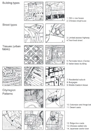
The primary form of knowledge in urban mor-phology is the recognition of patterns, at dif-ferent times and across places. Strictly speak-ing, the data collected by morphologists are always organized into sets of similar elements (for example, all streets), and these sets in and of themselves constitute patterns; that is, we recognize them as belonging to a fundamental class of things. However, the pattern recogni-tion in urban morphology that lends itself to more sophisticated knowledge accumulation is abstract, rather than objective, and derived from a comparative analysis of the physical data. Fixation lines, grids and matrix routes are examples of specific patterns. Patterns can sometimes be recognized through a computer algorithm, usually by radically minimizing the selected data (Stanilov, 2010). However, the complexity, diversity, volume and inter-relationships of most urban form data lead to abstract patterns that may be difficult to cap -ture in an algorithm, at least at present. Figure 2 shows some of the hundreds of patterns identified by urban morphologists.
Pattern recognition is theoretically one of the most critical aspects of developing human knowledge (Margolis, 1987). According to
gestalt theory, it is clear that humans will find patterns in most activities and physi -cal artifacts, especially in visual examples (Todorovic, 2008). Because they deal in measurable, mappable and mostly graphic data, morphologists are especially adept at finding and naming patterns that reveal them -selves by sight. However, research has shown that humans will find patterns even in random arrangements, which raises the question of their validity and may point to the ultimate importance of pattern recognition derived algorithmically.
Part of the validity, even of patterns derived algorithmically, comes from recognizing similar patterns in comparable circumstances. When we call something a ‘grid’, we are asserting its pattern similarity to other forms, as well as its own particular shape that we can easily ‘see’, even if it has been significantly distorted from an ancient time, like the plan of Florence. The pattern ‘grid’ is an abstraction from many different data points around the world: a grid pattern in Cincinnati, for exam-ple, is not ‘the’ grid, but an example of that pattern type. Commonly patterns are defined in more detail: for example, categorizing and naming many different sub- types of grids. This particularly happens with the common patterns we know as ‘building types’ (Firley and Stahl, 2009).
Patterns may be exclusive to a particular place, but identifying, comparing, and nam-ing those that occur over time and in different places is one of the key aims of urban mor-phology. In the Italian school, an operation known as ‘reading the city’ entails looking for similarities among forms, both current and historical. In the British school, a ‘plot series’ consists of similar plots laid out together. Patterns identified by British researchers and widely applied are fixation lines, plan units, and fringe belts (Conzen, 2004). Patterns identified and defined in the Italian School include matrix route, elementary cell, foun-dation type, tissue, pertinent strip and block (Caniggia and Maffei, 2001).
than one category of data. A building type, for example, is almost always associated with a certain scale and dimension of plot pattern: in
fact, most theories of change suggest that the two have a reciprocal relationship: the build-ing type initially generates the plot pattern and
Figure 2. Diagram of patterns. Patterns are interpreted from physical form data and are abstract conceptions that apply to multiple documented examples. They are recognized at different scales and each pattern may be
the plot pattern thereafter constrains the evo-lution of the building type (Scheer, 2010).
Unlike data, which objectively exist at all scales, patterns may only be evident at some-what specific resolutions of scale, as indicated graphically in Figure 2. A pattern of building types cannot be recognized by looking at the regional scale, for example. This concept of resolution, relates to another type of pattern recognition: the idea of a hierarchy in urban forms, in which smaller patterns are aggre-gated to form larger patterns. In a simpli-fied version of this, the recognized scales are building/plot, street/block, city, and region or territory (Kropf, 2014). Within the concept of hierarchy this is the relationship between pat-terns at different scales.
Pattern recognition is a respect in which morphologists can productively share their analyses. Different patterns can be identi-fied, even using the same data from the same place (Pinho and Oliveira, 2009). While there are infinite patterns and each may only be important in a particular place or in a particu-lar type of analysis, it is also axiomatic that similar patterns can be identified from place to place, and may even have some universal, or at least very wide, applications. An exam-ple is the concept of ‘fringe belts’, which have been identified in very different environments worldwide (Conzen, 2009).
Theories of change
Having recognized recurrent patterns, some morphologists have developed theories of autonomous change that are thought to have greater generality. These are theories about how patterns change, not why they change in any particular place. It is known that there are conditions not directly related to urban forms that drive changes in those forms. Autonomous theories of change are concerned with the dynamics of physical change itself, the assumption being that there are highly var-ied non- formal conditions that can induce or influence the same pattern of formal change. The theories of change in urban form include concepts such as constraint, persistence,
disruption, plot cycles, emergence, evolution, typological process, spatio- temporal hierar-chy, organic hierarhierar-chy, and cellular or axial relationships. These theories apply to data and pattern observations. They drive data collec-tion and interpretacollec-tion, becoming the basis for the most important kinds of knowledge in urban morphology.
Attempting to catalogue and compare the theories of change that are prevalent in urban morphology is beyond the scope of this paper. Kropf (2001) has provided insightful categorizations of change and more recently Whitehand et al. (2014) have compared change mechanisms across two cultures and across two schools.
Theories of autonomous change are quite diverse among the schools, but there are some basic, shared concepts. First, cities are built upon existing forms and by evolving, transforming and dispersing existing forms. These changes are reflected in concepts such as evolutionary cycles and the typological process. Secondly, there are similar dynamic interactions related to the effects of time and resolution that occur across many examples studied, implying that very different condi-tions can result in similar changes. Thirdly, certain physical forms tend to endure for a longer period of time than others in the same place. Fourthly, the persistence of some forms can retard changes that might happen more quickly if built forms were subject only to the forces of non- formal conditions.
Linkage to non- formal conditions
The field of urban morphology becomes more controversial when relating patterns to non- formal conditions. One of the validations of urban morphology is the correlation of obser-vations about physical form, its patterns and processes, with non- formal conditions and events. The patterns and changes observed in physical form (whether viewed synchroni-cally or diachronisynchroni-cally) have complex causes.
The changes that are observed and abstracted in the physical world are commonly related to known historical facts, land uses, popula-tion shifts, economic and cultural movements and political influences in a particular study area, as well as to general and culturally- conditioned human behaviour, habits and meaning. These correlations lead us to an understanding of why physical components changed in a particular place. The physical city then becomes another data point to be read and interpreted as a way of understand-ing history or to observe and correlate what is not observable by other means. While not
all urban morphologists correlate their find -ings to events, periods and conditions, all will understand this relationship. Many find that seeking these connections is the very purpose of the research investigation (Conzen, 2013). However, for empirical observations of urban morphologists to be validly correlated with other factors and conditions, it is critical that researchers are familiar with those other con-ditions (for example, land value) as well as with urban form.
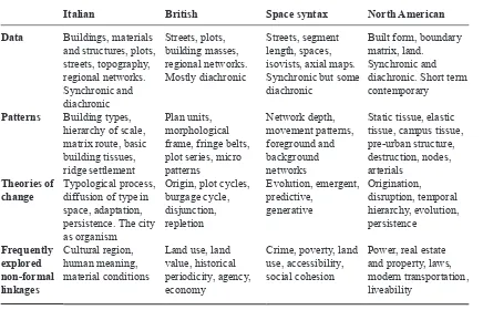
Table 1 briefly outlines four schools of thought in relation to the epistemological schema outlined above. These schools are compared according to the kinds of data they generally employ, the patterns they have iden-tified and compared in different places, and brief notes on theories of change that each has promoted. The table also notes the con-nections to non- formal conditions that each school has been interested in exploring. For each school, there is much more that could be said: the table is just an example of how the schema is applied. It could be expanded so that many other ideas and theories of urban
Table 1. Epistemological schema, demonstrated in four different lines of enquiry
Italian British Space syntax North American
Data Buildings, materials and structures, plots, streets, topography, regional networks. Synchronic and diachronic
Streets, plots, building masses, regional networks. Mostly diachronic
Streets, segment length, spaces, isovists, axial maps. Synchronic but some diachronic
Built form, boundary matrix, land.
Synchronic and diachronic. Short term contemporary
Patterns Building types, hierarchy of scale, matrix route, basic building tissues, ridge settlement
Plan units, morphological frame, fringe belts, plot series, micro patterns
Static tissue, elastic tissue, campus tissue, pre- urban structure, destruction, nodes, arterials
Theories of change
Typological process, diffusion of type in space, adaptation, persistence. The city as organism
Origin, plot cycles, burgage cycle,
Crime, poverty, land use, accessibility, social cohesion
morphology could be similarly compared with useful results. Examples of standpoints that arguably do not fit precisely within the ISUF canon include those of Bosselmann (2008), Lynch (1981), Marshall (2005) and Steadman (1979).
A common framework
One of the first steps to finding a common framework is to agree about what are data and what is analysis in our studies. In the present schema data collection is sharply defined as objective, and the analysis consists of three kinds of interpretative knowledge generation: pattern recognition, theories of change, and relations to non- formal conditions.
In searching for a simple framework that might include the many rich ideas of urban morphology and typology it became apparent that the common conflation of data and analy -sis was restraining the creation of comparable data from place to place. Similarly, patterns need to be recognized as abstractions that not only can be compared but also may occur in many places and times. Isolating patterns as such would be the first step to cataloguing them.
Although we cannot provide the same data from place to place, it is important to con-sciously recognize that measured and mapped data about a particular place at a particular time are different from the interpretation or analysis of those data as belonging to a class of patterns. For example, a city wall is a spe-cific construction that can be measured and tracked over different eras of a city’s develop-ment. When we call that same wall ‘a fixa -tion line’, we are interpreting it as a widely known pattern, and relating it to other patterns in other places and in other times. However, because in the common frameworks of urban morphology the data (the measurable infor-mation on the ground) are frequently con-flated with ideas about analysis, a plethora of seemingly conflicting conceptual ideas and terms results. This can be illustrated by the idea of ‘building type’. Type is a rich concept in urban morphology. When we document a
series of buildings and their plots (the data), we are apt to recognize them as being simi-lar but not identical (pattern recognition). We may call that pattern a ‘type’. Of course, the reason that we are documenting them at all is related to an a priori recognition of their simi-larity – in practice we cannot help but form ideas about patterns as we move through the world. Importantly, not one of the particular buildings we measure or photograph or docu-ment is the ‘type’. All are, instead, exem-plars of the type – by definition a type is an abstract concept (Caniggia and Maffei, 2001). Nevertheless, the buildings do or did exist and the documentation of the timing and nature of their change helps shape our ideas about the building type pattern these buildings may share with others as well as validate one or another theory of change.
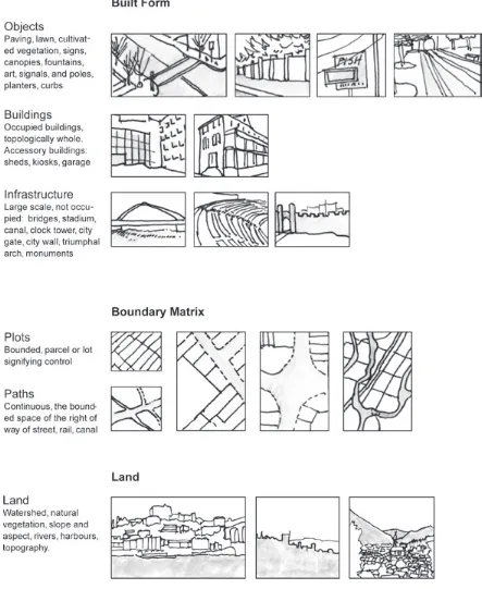
As we accumulate data about a place, we normally sort that information into categories. Here a very slight reorganization is proposed of the categories that constitute the common urban form elements that morphologists use, usually termed buildings, streets and plots. This reformulation assists with defining these elements separately from the patterns in which they appear. Figure 2 shows the kinds of data that are commonly collected to represent urban form, isolated from other conditions of the urban environment (that is, not related to land use or other non- physical data). The fol-lowing primary elements have been identified: built form, the boundaries of paths and plots, and land.
The following general principles about the elements are proposed:
1. They are universal and always present in a settled place. They can be compared across time and space, as long as reliable sources are available.
2. They are measurable in physical dimen-sions, or in relation to dates, or mathemati-cally calculated from measurable data (for example, isovists or density of plots). 3. They exist objectively. There may be
may be some ambiguity in the definition of a particular form element, in general the ambiguity rests in the definition, not in the physical form itself.
4. They are co- existent in space.
The three elements
The three elements described here vary from the building/plot/street formula that is commonly regarded as the fundamental building block of urban morphology. First, they are intended to be far more inclusive. They include land and objects that are not part of buildings. Secondly, the categoriza-tion of these elements is based on the need to easily distinguish one kind of element from another. Three categories have been developed. Built form has substantial real-ity and is man- made. The boundary matrix, which is defined as the combination of plots and the linear paths of public rights of way, describes lines and spaces that are measur-able and tracemeasur-able over time, even if they have no physical substance. Finally, land is the natural landscape terrain upon which the built form rests. These elements co- exist in space and may have literal co- presence – for example, a boundary may be marked by built form (for example, a wall) or a natural fea-ture (for example, a stream).
Built form is further broken down in Figure 3, where different kinds of built form are clas-sified. Three general categories are recog -nized – objects, which are non- occupied con-structions; buildings; and infrastructure. Built forms are independent pieces, although they are always composed of sub- parts. A building, for example, is independent of its plot in the sense that it can be demolished without affect-ing the plot boundaries.
The boundarymatrix (Figure 3) is perhaps the most overlooked of the three elements, especially by those not familiar with urban morphology’s traditions. The matrix is the subdivision of an area into bounded spaces. The matrix includes what we know of as plots or lots and also the space or right- of- way of the streets and the delimited space devoted
to other continuous paths (for example, high-ways, rails, trails, canals, greenways).
The early work of Conzen (1960) and Giovannoni (Marzot, 2002, p. 62) has led morphologists to recognize the ground plan (including plots) as a critical element in the organization of built form. However, it is not widely noted in urban morphology that streets and other continuous built forms also lie within their own ‘plots’, that is, the space they occupy and that is next to them that is bounded and owned by a civil authority or private utility (like a rail company or a canal company). If we understand the house as a built form that usually sits within a plot, then it is useful to conceive that the paving of the street and its accessory objects (kerbs, foot-paths, street trees, lighting, sewers) also sit within a designated, measurable and bounded space, that may be termed a ‘path’. As with all other elements, the paths and plots of the boundary matrix are measurable and, though they may lack substantive form, are at least recorded, or generally acknowledged, as fact.
In almost all urbanized places (in fact, in most places), paths and plots continuously underlie the entire built form, providing a slow- changing game board upon which built form plays. As complicated and varied as built form is, the boundary matrix is far simpler, and that simplicity helps us see the structure and the containers in which all built form largely rests. By isolating the elements that constitute the boundary matrix, it is possible to isolate and name some very clear patterns that appear in cross- cultural comparisons (Scheer, 2001). The boundary matrix relates to another impor-tant distinction: plots, and especially paths, have much greater endurance than buildings, and most theories of change are built upon this recognition. By unlinking, at least for the purposes of data collection, built form and boundary matrix, we may also start to have a consistent set of elements and maps from place to place and era to era.
plans use the containers/cells/spaces of the boundary matrix in GIS to record many kinds of data, which assists urban morphologists in their quest to connect physical form with
other conditions of urban life, economy, and history (Moudon and Hubner, 2000).
Land is the final category of elements. For purposes of urban morphology, the natural
vegetation, soils, water bodies and topogra-phy are the key data points, although other categories pertaining to the natural landscape may also be important from time to time to describe the form of a city. Land is sometimes neglected or only referred to at larger scales, but it is present at all scales and it frequently influences building types and the evolution of even very small sites. In contemporary mor-phological studies, the natural landscape has become a very important element because its interaction with built form and the boundary matrix can illuminate an ecological perspec-tive on the form of the city, even historically. There is a certain amount of ambiguity in the definition of these elements. A particular example is the boundary matrix, because its presence requires a recording of the land sub-division or at least a specific agreement among a group of people: this might be clear even in a very early society, even if it is based on bounda-ries defined by elements on the land (for exam -ple, a river) or a traditional fence. While these boundaries usually signify control, commu-nal land ownership can be more complicated, although in practice, boundaries can usually be identified. In many places, eras, and condi -tions, boundaries can sometimes be established apart from ownership (Akbar, 1988).
Conclusion
This paper demonstrates that morphologists can compare their contributions to the knowl-edge base, using a simple epistemological schema. The schema is not built on a common methodology, rather on the understanding of the kinds of knowledge that are produced. These include the data that are gathered as objectively as possible, and the three general kinds of interpretation: pattern recognition, autonomous theories of change, and linkage to non- formal conditions.
The comparison of the schools under this schema is incomplete in this paper. However, if it could be rigorously pursued, the comparison could begin to provide clarity in relation to the terms and concepts of the field, without requir -ing that one or another research technique be
brought into conformity. This framework also allows researchers from outside ISUF’s can-non to draw connections to that work and productively introduce new patterns and new and revised theories of change based on the observation and study of very different kinds of urban growth patterns and forms.
The context of this topic is often the distinc-tion that separates the epistemological frames of different schools. For example, the Italians based their data and analysis on the transfor-mation and continuing evolution of the forms of the ancient world, while the British did the same with the medieval one. Although Asian urban morphologists have not formulated a separate school of thought, that may arise. A North American school, focused on newer urban forms, arguably has already come into existence. Despite different contexts, compar-ative analysis across cultures enriches urban morphology. Comparisons can share not only techniques, but assumptions about how knowl-edge accumulation works in each school.
Finally, using a common framework and definitions for the primary elements, it would be possible to compare, say, a boundary matrix in the suburbs of the US with the same element in the city centre or in a European city. Clarifying the distinctions between data and patterns allows the comparison and cata-loguing of both, perhaps enabling a scientific renaissance that can increase urban morphol-ogy’s influence.
References
Akbar, J. A. (1988) Crisis in the built environment: the case of the Muslim city (Concept Media, Leiden).
Bafna, S. (2003) ‘Space syntax: a brief introduc-tion to its logic and analytical techniques’, Environment and Behavior 35, 17–29.
Bosselmann, P. (2008) Urban transformation: understanding city design and form (Island Press, Washington, DC).
Caniggia, G. and Maffei, G. C. (2001) Architectural composition and building typology: interpreting basic building (Alinea, Firenze).
the urban fabric’, unpublished paper presented to the Twenty- First International Seminar on Urban Form, Porto, July.
Conzen, M. P. (2009) ‘How cities internalize their former urban fringes: a cross- cultural compari-son’, Urban Morphology 13, 29–54.
Conzen, M. P. (2013) ‘Substance, method and meaning in urban morphology’, Urban Morphology 17, 132–4.
Conzen, M. R. G. (1960) Alnwick, Northumberland: a study in town- plan analysis Institute of British Geographers Publication 27 (George Philip, London).
Conzen, M. R. G. (2004) Thinking about urban form: papers on urban morphology, 1932–1998 (Peter Lang, Oxford).
Firley, E. and Stahl, C. (2009) The urban housing handbook (Wiley, Chichester).
Gauthier, P. and Gilliland, J. (2006) ‘Mapping urban morphology: a classification scheme for interpreting contributions to the study of urban form’, Urban Morphology 10, 41–50.
Hillier, B. and Hanson, J. (1984) The social logic of space (Cambridge University Press, Cambridge).
Jacobs, A. B. (1993) Great streets (MIT Press, Cambridge, MA).
Koter, M. (1990) ‘The morphological evolution of a nineteenth- century city centre: Łódź, Poland, 1825–1973’, in Slater, T. R. (ed.) The built form of Western cities: essays for M. R. G. Conzen (Leicester University Press, Leicester) 109–41. Kropf, K. (2001) ‘Conceptions of change in the
built environment’, Urban Morphology 5, 29–42. Kropf, K. (2009) ‘Aspects of urban form’, Urban
Morphology 13, 105–20.
Kropf, K. (2011) ‘Morphological investigations: cutting into the substance of urban form’, Built Environment 37, 393–408.
Kropf, K. (2013) ‘Evolution and urban form: stak-ing out the ground for a more mature theory’, Urban Morphology 17, 136–49.
Kropf, K. (2014) ‘Ambiguity in the definition of urban form’, Urban Morphology 18, 41–57. Kropf, K. and Malfroy, S. (2013) ‘What is urban
morphology supposed to be about: specializa-tion and the growth of a discipline’, Urban Morphology 17, 128–31.
Larkham, P. J. (2006) ‘The study of urban form in Great Britain’, Urban Morphology 10, 117–41. Lynch, K. (1981) Theory ofgood city form (MIT
Press, Cambridge, MA).
Margolis, H. (1987) Patterns, thinking and cogni-tion (University of Chicago Press, Chicago). Marshall, S. (2005) Streets and patterns: the
struc-ture of urban geometry (Spon, London).
Marzot, N. (2002) ‘The study of urban form in Italy’, Urban Morphology 6, 59–73.
Moudon, A. V. (1992) ‘A catholic approach to organizing what urban designers should know’, Journal of Planning Literature 6, 331–49. Moudon, A. V. (1997) ‘Urban morphology as
an emerging interdisciplinary field’, Urban Morphology 1, 3–10.
Moudon, A. V. and Hubner, M. H. (2000) Monitoring land supply with Geographic Information Systems: theory, practice, and parcel- based approaches (Wiley, New York). Oliveira, V., Monteiro, C. and Partanen, J. (2015)
‘A comparative study of urban form’, Urban Morphology 19, 73–92.
Panerai, P., Castex, J., Depaule, J- C. and Samuels, I. (2004) Urban forms: the death and life of the urban block (Architectural Press, Oxford). Pinho, P. and Oliveira, V. (2009) ‘Different
approaches in the study of urban form’, Journal of Urbanism 2(2), 103–25.
Rowe, C. and Koetter, F. (1978) Collage city (MIT Press, Cambridge, MA).
Scheer, B. C. (2001) ‘The anatomy of sprawl’, Places 14(2) 28–37.
Scheer, B. C. (2010) The evolution of urban form: typology for planners and architects (American Planning Association, Chicago, IL).
Stanilov, K. (2010) ‘Bridging the gap between urban morphology and urban modelling’, Urban Morphology 14, 123–4.
Steadman, P. (1979) The evolution of designs: bio-logical analogy in architecture and the applied arts (Cambridge University Press, Cambridge). Todorovic, D. (2008) ‘Gestalt principles’,
Scholarpedia 3, 5345 (http://www.scholarpedia. org/article/Gestalt_principles) accessed 21 July 2015.
Turri, J. (2014) Epistemology: a guide (Wiley, London).
Whitehand, J. W. R. (2001) ‘British urban mor-phology: the Conzenian tradition’, Urban Morphology 5, 103–9.