Article
Qualitative spaces: Integrating spatial analysis for a mixed methods approach
Zawadi Rucks-Ahidiana, Graduate Student Sociology
University of California, Berkeley Berkeley, United States
Ariel H. Bierbaum, Ph.D. (Cand) City and Regional Planning University of California, Berkeley Berkeley, United States
© 2015 Rucks-Ahidiana and Bierbaum. This is an Open Access article distributed under the terms of the Creative
Commons‐Attribution-NonCommercial-ShareAlike License 4.0 International
(http://creativecommons.org/licenses/by-nc-sa/4.0/), which permits unrestricted use, distribution, and reproduction in any medium, provided the original work is properly attributed, not used for commercial purposes, and if transformed, the resulting work is redistributed under the same or similar license to this one.
Abstract
Spatial context matters for qualitative social science inquiry. Yet, the explicit and consistent integration of these analyses has largely been segregated to the spatial sciences, geography and urban planning. In this article, we present a theoretical argument for integrating spatial data in qualitative inquiry and strategies for how to triangulate spatial and qualitative data. We argue that including spatial analyses in inquiries of social phenomena enhances depth and rigor to qualitative work across the social sciences.
In social science qualitative inquiry, spatial context matters to our understanding of social phenomena. Despite this, the explicit and consistent integration of spatial analyses has largely been limited to a subset of social sciences, particularly geography and urban planning. In fact, some social sciences—most notably sociology—seem to have largely abandoned their spatial roots both methodologically and analytically. In this article, we illustrate how qualitative social scientists and, in particular, sociologists can return to their roots of spatial analysis, leveraging it to enhance and to expand their research agendas.
Spatial data generally are used in two main ways in qualitative research studies, with varying descriptive and analytical power. First, statistics (e.g., demographic data) associated with specific geographic boundaries provide a broader sense of the context in which social processes emerge. These kinds of statistics are most often deployed descriptively in the form of tables or maps. Second, some scholars use spatial data to examine patterns and trends, integrating spatial data into the analysis. This comes in the form of maps as tools for identifying patterns between the area of study and its surrounding areas, and the triangulation of spatial and qualitative data sources to analyze qualitative data by its spatial characteristics. These approaches can be leveraged analytically to address research questions and to reveal new areas of inquiry.
Spatial description is prevalent in ethnographic and case study inquiries, as well as some qualitative interviews, participant observation, and archival or document review projects, due to their attention to contextual factors. However, we argue that the analysis of spatial data is largely missing from qualitative research, particularly in sociology. In this article, we argue that spatial analysis should play a larger role in qualitative inquiry. We present a theoretical argument for integrating spatial analysis in qualitative methods by comparing illustrative examples in three areas of sociological research: social capital, immigration, and education. Additionally, we share strategies for triangulating spatial and qualitative data. Although we target our critique to sociology, our conclusions and recommendations are relevant across the social sciences.
The article proceeds as follows: First, we describe some key historical precedents for the use of spatial analysis in sociological qualitative research and provide a working definition of spatial analysis. We provide empirical evidence of the lack of spatial analysis in qualitative sociological inquiry. Next, we highlight a study in each of the selected topic areas—social capital,
immigration, and education—and discuss the value added of spatial analysis, highlighting the specific research questions that they inspire and address. We do not intend these cases to be exhaustive, but rather illustrative, and to serve as a vehicle that provides initial insight into the utility of spatial analysis in each of these domains. Finally, we provide some strategies for triangulating spatial and qualitative data. Ultimately, we argue that including spatial analyses in inquiries of social phenomena—including those that ostensibly seem aspatial—enhances depth and rigor to qualitative work across the social sciences.
Precedents for Spatial Analysis in Sociological Investigation
Although much of modern day sociology treats space as a container in which social processes occur, theorists such as Lefebvre (1991) illustrate that space is a social construction. Space is both created by and allows for social interactions and relationships, the reinforcement of social
hierarchies, and the deployment of power (Abbott, 1997; Gieryn, 2000; Lobao, 1996; Logan, 2012). In other words, the study of a location captures a unique configuration of social relationships that reinforces and implements pre-existing social hierarchies.
As Lefebvre (1991) details, the social and the spatial are inextricably linked: “space is a [social] product” (p. 26). The variations in these social configurations and histories across locations result in differential development patterns in space, which then produces differential social processes, and so on. Thus, space is created through social construction, which then informs the
Interestingly, sociologists often assume that macro-structural forces affect individuals similarly; however, these theorists highlight how the transmission of macro-structural forces at the local level involves varied socio-spatial settings in which structural processes manifest differentially.
This theoretical case for place is strongly present in the origins of sociological investigation in the United States, which generally correspond with the rise of the industrialized city and its attendant inequality and social ills (Hall, 2002). Spatial analysis was inherent in these early studies of social life. For example, Charles Booth’s (1892) 17-volume study, Life and Labour of the People in London, and Jacob Riis’s (1890) volume, How the Other Half Lives: Studies among the
Tenements of New York, provided never-before-seen documentation of the lives of those living in poverty in the industrial city. Both of these surveys sought to document and to categorize people living in poverty and, by extension, the places that they inhabited. Booth made extensive use of statistics and maps, providing an early articulation of the geography of poverty. His spatial lens mapped the entire city of London, and offered a new way to read the city along lines of economic inequality. Riis, one of the first social documentary photographers in the United States, took advantage of new portable camera technology and created a photographic catalogue of the tenement conditions in New York City. He offered visual evidence of the texture and lived experience in particular places. Both works signal a shift in understanding the city, specifically in seeing neighborhoods as a discrete unit where particular physical and demographic characteristics manifested and aggregated.
Less than a decade later, W. E. B. Du Bois (1899) deployed similar social survey methods in his seminal work The Philadelphia Negro. Like Booth, Du Bois sought to map the full city (in his case, Philadelphia), and then hone in on specific areas that housed concentrations of African Americans to document their social exclusion. His spatial analysis revealed manifestations of structural forces of slavery and the labor market through an analysis of the physical environment, neighborhood, and housing conditions, and the spatial distribution of the African American population. Du Bois’ spatial analysis augments his argument that the plight of African Americans stems from a number of factors that manifest in space including: unemployment, lack of training, low wages, immigration and migration patterns, and racism.
Booth, Riis, and Du Bois represent a few of the early users of spatial analysis in the context of qualitative research inquiries. These Progressive Era efforts laid an important foundation for academic inquiry of urban change, which informed the Chicago School of sociology. Maintaining a positivist philosophy, sociologists at the University of Chicago approached their city as a laboratory. The Chicago School picked up earlier theories connecting urbanization to social disorganization and disconnection, focusing on the psycho-sociological impacts of urbanization. They narrowed their scale of inquiry to individuals, communities, and their physical vessels: neighborhoods. As Abbott (1997) remarks, the Chicago School “felt that no social fact makes any sense abstracted from its context in social (and often geographic) space and social time” (p. 1152). Witnessing significant urban change, they sought to theorize the mechanisms of these transformations. Their research focused on social ecology, racial and ethnic identity, and social disorganization, and they used a range of data collection and analysis methods, including “statistical, ethnographic, quantitative, and qualitative techniques” (O’Connor, 2001, p. 45). These methods were specifically used for spatial analysis to understand social dynamics.
Their social ecological approach conceptualized neighborhoods as a closed ecosystem in which social life occurred. In this approach, individuals are embedded in their spatial environments both forming and formed by their surroundings. Following from this, competition for space among groups drove locational decisions; neighborhood change followed a natural tendency towards social equilibrium. New actors (in the case of Chicago, incoming immigrant populations) would enter the ecosystem and disrupt the equilibrium. Competition for space followed, and
dominant groups that stayed established a new equilibrium. Spatial analysis was intrinsic to their theorization and methodological approach. Subsequent scholars (e.g., Drake & Cayton 1945) adopted these methodological innovations, but used them to challenge the dominant theorization of cities and naturalized neighborhood succession to explain the persistent segregation of the African American community in Chicago.
These early innovations in methodology and theory influenced the direction of urban sociology and the training of subsequent generations of sociologists. This legacy is seen most strongly in the theoretical orientation of neighborhoods as naturalized urban ecosystems and the positivist methodological approach, which introduced systematic surveys, observations, and quantifiable measures to investigations of urban change and spatial characteristics. Despite this legacy, the more recent study of topics central to the Chicago School agenda, race, immigration, and poverty, generally lack spatial analysis with a few exceptions.
Notably, the work of William Julius Wilson (1987) and his analysis of urban change and increasing inner city Black poverty leveraged spatial analyses in the development of such concepts as concentration effects, social isolation, and spatial mismatch. Subsequent scholars have used ethnographic and spatial analysis to challenge and to engage in Wilson’s ideas. For example, Mary Pattillo (2013) in Black Picket Fencesdisrupts Wilson’s notion of social isolation,
highlighting the Black middle class’ ties to poor Black communities through social networks and spatial proximity of residence. Massey and Denton (1993) emphasized the spatiality of racial discrimination as manifested in the housing market. Finally, Wacquant (1998, 2008) extended Massey and Denton’s (1993) focus on residential segregation with the concept of racial enclosure
to understand the relationship among race, poverty, and space in his ethnographic studies of urban decline.
More recently, spatial data have been deployed in quantitative studies of inequality and racial and income segregation (see e.g., M. J. Fischer, 2003; Reardon & Bischoff, 2011; Watson, 2009), and broadened analyses from the neighborhood level to metropolitan, county, and state geographies (see e.g., C. S. Fischer, Stockmayer, Stiles, & Hout, 2004; Massey, Rothwell, & Domina, 2009; Reardon et al., 2008). Spatial analysis also has been central in the neighborhood effects literature, in which researchers use both qualitative and quantitative approaches to uncover causal
mechanisms among concentrations of poverty, racial groups in neighborhoods, and subsequent negative life outcomes (see e.g., Ellen & Turner, 1997; Galster, 2010; Jencks, Mayer, Lynn, & McGeary, 1990; Sampson, 2011a, 2011b; Sharkey, 2013).
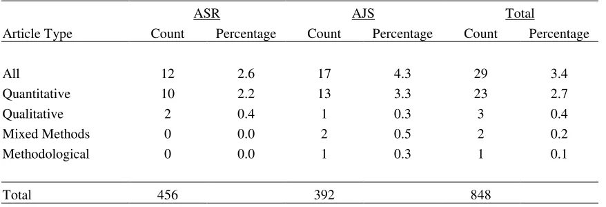
Despite the use of spatial analysis in these works, current qualitative sociological inquiry largely neglects spatial analysis. In a review of American Sociological Review (ASR) and American Journal of Sociology (AJS) from 2004 to 2014, we searched the table of contents and abstracts of 131 issues and 848 articles for the use of key words including spatial, geography,
Table 1
Use of Spatial Analysis in Sociological Journals from 2004 to 2014
ASR AJS Total
Article Type Count Percentage Count Percentage Count Percentage
All 12 2.6 17 4.3 29 3.4
Quantitative 10 2.2 13 3.3 23 2.7
Qualitative 2 0.4 1 0.3 3 0.4
Mixed Methods 0 0.0 2 0.5 2 0.2
Methodological 0 0.0 1 0.3 1 0.1
Total 456 392 848
Sources: American Sociological Review (ASR) and American Journal of Sociology (AJS), 2004-2014.
While the lack of spatial analysis in sociology is a problem across the discipline, qualitative sociologists have particularly neglected the spatial aspects of their studies, leaving those elements to spatial experts in urban planning and geography. Yet, as the work of scholars like Booth, Riis, and Du Bois highlights, the social is organized spatially, suggesting a particular imperative for sociologists (Abbott, 1997). Investigating the spatial components of socio-spatial processes furthers our theoretical and empirical understanding of the social processes that we study, including how location matters for social phenomenon.
Qualitative researchers can augment their studies of socio-spatial processes with spatial analysis with two approaches: spatial description and spatial analysis (see Table 2). Spatial description is generally presented with maps and statistics that describe the context of the research site. Although prevalent in social science research, descriptive statistics are usually segregated from analysis in qualitative research, contained in a background or contextual section of a work rather than integrated in the analysis and findings sections. When these spatial descriptors are
incorporated into an analysis, they are often used as context, such as providing statistics about a neighborhood that an informant discusses. Although description is important, the analytic gains are minimal.
Table 2
Using Spatial Data
Primary Use Examples
Spatial
Description Setting context Maps and statistics of spatial unit characteristics
Spatial Analysis Analyzing patterns and trends Maps of spatial patterns and trends
Triangulation of spatial and qualitative data
characteristic changes over time. For qualitative research, spatial analysis also includes the triangulation of spatial and qualitative data. For example, interview data might be analyzed by characteristics of the interviewee’s residential neighborhood. Ultimately, spatial analysis does more than describe spatial data by analyzing patterns and trends (Lubienski & Dougherty, 2009).
In the remainder of this article, we illustrate the power of spatial analysis in qualitative work through examples from the existing literature on social capital, immigration, and education. In each of these three issue areas, we present a case that uses spatial analysis to illustrate the analytic gains of a spatial approach.
Case Examples of Spatial Analyses
The examples below represent published articles that explore socio-spatial processes through a mixed methods research approach, bringing together spatial analysis and qualitative research methods. These three examples provide examples of how spatial data can be used analytically and inspire reflection on what could be gained by the use of spatial analysis. For each study, we provide a short summary of the broader literature, a description of their data and analysis techniques, and reflections on how spatial analysis enhanced each work. As stated above, we do not intend these examples to be exhaustive, but rather use these cases as an illustrative vehicle to provide preliminary insight into and provoke further discussion of the value-added of spatial analysis in each of these domains of social science research, discussed in the conclusion.
Social Capital
Social capital represents the actual or potential resources from the aggregate of relationships or social ties that an individual holds (Bourdieu, 1986; Coleman, 1988). The study of social capital represents a socio-spatial phenomenon due to the formation of relationships in particular
locations. In fact, theory on social networks includes spatial assumptions about relationship formation based on the proximity or distance of ties (Bridge, 2002; Guest, Cover, Matsueda, & Kubrin, 2006). Despite this, much of the qualitative literature on social capital is aspatial, focusing on network ties without considering their location in the geographic area of study or the proximity to the research subject. Rowe and Wolch (1990) illustrate the added benefits of spatial analysis for social network studies in their study of homeless populations.
Using ethnographic and interview data, Rowe and Wolch (1990) examine the spatial patterns of homeless women’s networks over time. The spatial elements of their study include three approaches. First, they provide a descriptive analysis of the area of study, Skid Row in Los Angeles, and the location of institutional supports and resources available to the homeless in the neighborhood and surrounding area. Second, they analyze daily spatial patterns of their
interviewees and how their daily movement relates to different aspects of their social network, including maps of their daily patterns. Finally, they consider how changes in their social networks and “home base” locations influence their respondents’ spatial patterns and connections to different aspects of their social networks.
Immigration
Although the study of immigration has traditionally focused on immigration entry points such as New York City or San Francisco, the increase of immigrant populations across the United States has expanded the locations of interest to this literature. Part of the change in immigration patterns is where immigrants are settling, with rising numbers in suburban communities rather than inner city areas traditionally associated with immigration (Garr & Kneebone, 2010; Kneebone & Berube, 2013). Importantly, patterns of immigration vary by country of origin and educational attainment, which fuels regional differences in immigration patterns. These spatial variations have led to interest in the service environment of areas inhabited by various immigrant
populations. de Graauw, Gleeson, and Bloemraad (2013) explore this through spatial analysis in their study comparing immigrant centered services in central city and suburban locations.
Using a mixed methods research design, de Graauw et al. (2013) analyze the response to growing immigrant populations in suburbs and new gateway cities. The authors specifically treat these expansions in immigration as a socio-spatial process, analyzing the data within the spatial context in two ways. First, they take a regional approach, comparing four cities in the same region. This allows them to control for regionally specific differences, while also analyzing the influence of the immigration history and service environment in a proximate area, San Francisco. The regional approach is central to their main findings, which include that due to their smaller scale and more recent influx of immigrants as compared to San Francisco, city officials outside of San Francisco either do not realize the extent of immigration to the city or do not realize the immigrant
population has a need for services not provided.
Second, they analyze interview, archival, and administrative data from each city in the context of the socio-spatial process of immigration and poverty. As the authors describe, “Attention to place is critical for understanding public-private partnerships that target disadvantaged groups: the poor tend to be concentrated in particular areas, community organizations operate in specific locations, and government allocations are usually made within circumscribed political jurisdictions” (de Graauw et al., 2013, p. 79). Treating immigration as a socio-spatial process means that the authors triangulate aspatial data with spatial data. Thus, the proportion of government funding provided to immigrant organizations (aspatial data) is analyzed in relation to both the number of immigrant organizations in the city of study (aspatial data), and the proportion of immigrants and immigrants living in poverty (spatial data). Funding inadequacy thus is derived from both the financial and demographic demand. de Graauw et al. (2013) successfully demonstrate the feasibility of more rigorous spatial analyses.
Education
Educational researchers and sociologists grapple with complex conditions within and across school sites and districts. Many studies have centered on district- or school-level policies and outcomes for individual or groups of students. One persistent problem in urban schooling is racial and class segregation. This school segregation reflects patterns of residential segregation across neighborhoods and metropolitan areas, as most school placement is based on neighborhood of residence, and leads to negative outcomes for students (e.g., Orfield & Lee, 2005).
policies inherently have a spatial component, shifting the geographies of schooling across district. Despite this, most educational research on school choice focuses not on questions of geography or space. Bell (2009) is an exception, interrogating parental decision-making as a spatial process, in which parents strongly consider distance traveled and place-based.
Bell (2009) uses “two conceptions of geography-space and place” (p. 492) to understand the ways in which geography along these two dimensions played into parents’ choices for schooling in Detroit. She argues that geography is important for the broader understanding of parents’ decision-making and school choice policies. To set the context, Bell (2009) details the spatiality of schools including their ties to neighborhood and the links between residential and educational choices, thereby indicating that geography is a key component of parental decision-making. Bell (2009) deploys an analytic frame that discerns the dimensions of space and place as the two components of geography:
Geography as space is operationalized through variables such as distance, commute time, and the availability of transportation. It is measured in miles and minutes…Place refers to the social, economic, and political meanings people assign to particular spatial locations…these meanings are not universal. (p. 495)
Bell (2009) interviewed parents with children entering new schools in either the sixth or ninth grade three times: before, during, and after their selection process. Her analysis is not only of the interview data, but also spatial analyses using maps “to look more closely at how and when geographic preferences caused parents’ choice sets and geographic sets to differ” (p. 502). By triangulating mapping tools with her interview data, Bell captures the nuance of parental decision-making and addresses new questions about urban and educational policy that take into account space and place considerations in school-choice policies.
Integrating Spatial Data in Qualitative Inquiry
As the examples described earlier illustrate, the use of spatial data in qualitative research can open up new areas of inquiry and expand understanding of socio-spatial processes. However, the intellectual and practical task of integrating spatial analysis in the study of social processes is not necessarily obvious. In this section, we describe tools of mapping and data triangulation for integrating these pieces of data in a robust, mixed methods analysis.
Maps provide a visual representation of the spatial dynamics of a social phenomenon or process. Although summary statistics are useful to present a social process, phenomenon, or characteristic, they do so in an aspatial way, providing no indication of the spread or distribution of such
processes across a given geography. Maps, on the other hand, illustrate patterns across specified areas, allowing researchers to identify the actual spatial distribution instead of assuming equal distribution. Thus, qualitative social scientists can use maps to analyze spatial clusters, proximity between areas with varied characteristics and resources, change in the process or phenomenon of interest over time, the spatial relationship between two or more phenomenon or processes, and/or historical patterns of the same and related phenomenon and processes. This can include data about characteristics of geographic areas or locations of specific institutions and resources. Whether applied to understand regional dynamics of a socio-spatial process as seen in de Graauw et al. (2013) or local dynamics as seen in Bell (2009) and Rowe and Wolch (1990), these analyses provide insight to larger processes by which social life operates within space. Just as Booth and Du Bois learned the craft of hand drawn mapping for their work, researchers today might need to acquire new skills—for example the use of Geographic Information Systems (GIS) to create analytical maps.
integration manually or use qualitative data analysis (QDA) software packages. Either way, they can use findings from spatial analysis to relate a set of attributes or characteristics linked to other qualitative data. For example, spatial analysis might reveal levels of segregation (e.g., low, medium, high) across neighborhoods. Researchers then might take this information and analyze interview data by linking residential addresses with levels of segregation.
As articulated here, researchers can use a staged process, first developing maps for spatial analysis and then triangulating these findings with other qualitative data. Starting with maps allows the researcher to identify what is most salient for the qualitative analysis without assuming spatial patterns that might or might not be present. Additionally, this triangulation can reveal where spatial patterns influence the qualitative findings rather than assuming spatial patterns are inherently reflected in the qualitative data.
Conclusion
Although the classics of sociology used spatial analysis across both qualitative and quantitative inquiry, our empirical work illustrates that today’s sociological investigations largely overlook the spatial patterns of social phenomenon. This article documents the opportunities that
triangulating spatial and qualitative data present. Spatial analysis can reveal nuanced findings and open up new areas of inquiry across a range of studies. Qualitative researchers can understand how the spatial patterns of social processes affect the behavior and actions of participant observation participants, the experiences and perspectives of interview participants, and the priorities and focus of documents.
Although we advocate for an integration of spatial analysis within qualitative studies, we acknowledge that this is not always an obvious endeavor for several reasons. First, the spatial aspects of some topics of study are not always as apparent as the social aspects. In fact, most social scientists are trained to prioritize social patterns and, thus, overlook spatial patterns (Davis, n.d.). Using an analytical approach to spatial data analysis requires the researcher to evaluate the relevance and importance of place for her or his study.
Second, spatial data might not be readily available in a form that is meaningful for the study, either in the appropriate unit of analysis of interest or time period of study. For example, a researcher interested in a specific neighborhood might not find a census tract or zip code that closely aligns with the socially understood boundaries of that area. Additionally, Census data, which is the most frequently used spatial data, are available every 10 years, which might not align with the years of study. However, researchers can also compile their own spatial data through observations (see Rowe & Wolch [1990] and Bell [2009] as examples).
Finally, spatial data are often (but not always) in the form of quantitative data, as seen in some of the examples above. Researchers who specialize in qualitative methods might feel less
comfortable navigating this type of data. However, the analytical approach we promote is based primarily on triangulation of qualitative and spatial data, which is easily accomplished within most qualitative data analysis software packages without any advanced statistical skills or tools.
References
Abbott, A. (1997). Of time and space: The contemporary relevance of the Chicago School. Social Forces, 75, 1149–1182. doi:10.1093/sf/75.4.1149
Ball, S. J. (1993). Education markets, choice and social class: The market as a class strategy in the UK and the USA. British Journal of Sociology of Education, 14(1), 3–19.
doi:10.1080/0142569930140101
Belfield, C. R., & Levin, H. M. (2009). Market reforms in education. In G. Sykes, B. Schneider, & D. N. Plank (Eds.), Handbook of education policy research. New York, NY: American Educational Research Association by Routledge Publishers. Retrieved from
http://library.mpib-berlin.mpg.de/toc/z2010_1887.pdf
Bell, C. (2009). Geography in parental choice. American Journal of Education, 115, 493–521. doi:10.1086/599777
Booth, C. (1892). Life and labour of the people in London. London, England: Macmillan.
Bourdieu, P. (1986). The forms of capital. In J. F. Richardson (Ed.), Handbook of theory of research for the sociology of education (pp. 241–258). New York, NY: Greenwood.
Bridge, G. (2002). The neighbourhood and social networks. Bristol, England: ESR Centre. Retrieved from http://www.urbancentre.utoronto.ca/pdfs/curp/CNR_Neighbourhoods-Social-N.pdf
Coleman, J. S. (1988). Social capital in the creation of human capital. American Journal of Sociology, 94, S95–S120. doi:10.1086/228943
Davis, D. (n.d.). Some preliminary thoughts on inequality and urban space: Looking back, thinking comparatively, heading forward. The Cities Papers. Retrieved from
http://citiespapers.ssrc.org/some-preliminary-thoughts-on-inequality-and-urban-space-looking-back-thinking-comparatively-heading-forward/
de Graauw, E., Gleeson, S., & Bloemraad, I. (2013). Funding immigrant organizations: Suburban free riding and local civic presence. American Journal of Sociology, 119, 75–130. doi:10.1086/671168
Drake, S. C., & Cayton, H. R. (1945). Black metropolis: A study of Negro life in a northern city. New York, NY: Harcourt, Brace and Company.
Du Bois, W. E. B. (1899). The Philadelphia Negro: A social study. New York, NY: Schocken Books.
Ellen, I. G., & Turner, M. A. (1997). Does neighborhood matter? Assessing recent evidence.
Housing Policy Debate, 8, 833–866. doi:10.1080/10511482.1997.9521280
Fischer, M. J. (2003). The relative importance of income and race in determining residential outcomes in U.S. urban areas, 1970-2000. Urban Affairs Review, 38, 669-696. doi:10.1177/1078087403038005003
Galster, G. C. (2010, February). The mechanism(s) of neighborhood effects: Theory, evidence, and policy implications. Paper presented at the ESRC Seminar: Neighborhood Effects: Theory & Evidence, St. Andrews University, Fife, Scotland.
Garr, E., & Kneebone, E. (2010). The suburbanization of poverty. Retrieved from http://www.brookings.edu/research/papers/2010/01/20-poverty-kneebone
Gieryn, T. F. (2000). A space for place in sociology. Annual Review of Sociology, 26, 463–496. doi:10.1146/annurev.soc.26.1.463
Guest, A. M., Cover, J. K., Matsueda, R. L., & Kubrin, C. E. (2006). Neighborhood context and neighboring ties. City & Community, 5, 363–385. doi:10.1111/j.1540-6040.2006.00189.x
Hall, P. (2002). Cities of tomorrow: An intellectual history of urban planning and design in the twentieth century (3rd ed.). Malden, MA: Wiley-Blackwell.
Jencks, C., Mayer, S., Lynn, L. E. J., & McGeary, M. G. H. (1990). The social consequences of growing up in a poor neighborhood. In inner-city poverty in the United States (pp. 111– 186). Washington, D.C.: National Academy Press.
Kneebone, E., & Berube, A. (2013). Confronting suburban poverty in America. Washington, D.C.: Brookings Institution Press.
Ladd, H. F. (2002). Market-based reforms in urban education. Washington D.C: Economic Policy Institute. Retrieved from http://www.epi.org/publication/books_ladd-educationreform/
Lefebvre, H. (1991). The production of space. Oxford, England: Blackwell.
Lobao, L. (1996). A sociology of the periphery versus a peripheral sociology: Rural sociology and the dimension of space1. Rural Sociology, 61, 77–102. doi:10.1111/j.1549-0831.1996.tb00611.x
Logan, J. R. (2012). Making a place for space: Spatial thinking in social science. Annual Review of Sociology, 38, 507-524. doi:10.1146/annurev-soc-071811-145531
Lubienski, C., & Dougherty, J. (2009). Mapping educational opportunity: Spatial analysis and school choices. American Journal of Education, 115, 485–491. doi:10.1086/599783
Massey, D. S., & Denton, N. A. (1993). American apartheid: Segregation and the making of the underclass. Cambridge, MA: Harvard University Press.
Massey, D. S., Rothwell, J., & Domina, T. (2009). The changing bases of segregation in the United States. The ANNALS of the American Academy of Political and Social Science, 626(1), 74–90. doi:10.1177/0002716209343558
Orfield, G., & Lee, C. (2005). Why segregation matters: Poverty and educational inequality. Los Angeles, CA: The Civil Rights Project, University of California-Los Angeles.
Pattillo, M. E. (2013). Black picket fences: Privilege and peril among the black middle class (2nd ed.). Chicago, IL: University of Chicago Press.
Reardon, S. F., & Bischoff, K. (2011). Income inequality and income segregation. American Journal of Sociology, 116, 1092–1153. doi:10.1086/657114
Reardon, S. F., Matthews, S. A., O'Sullivan, D., Lee, B. A., Firebaugh, G., Farrell, C. R., & Bischoff, K. (2008). The Geographic Scale of Metropolitan Racial Segregation.
Demography, 45, 489–514. doi:10.1353/dem.0.0019
Riis, J. A. (1890). How the other half lives: Studies among the tenements of New York. Boston, MA: Bedford Books of St. Martin's Press.
Rowe, S., & Wolch, J. (1990). Social networks in time and space: Homeless women in skid row, Los Angeles. Annals of the Association of American Geographers, 80, 184-204.
doi:10.1111/j.1467-8306.1990.tb00287.x
Sampson, R. J. (2011a). Great American city: Chicago and the enduring neighborhood effect. Chicago, IL: The University of Chicago Press.
Sampson, R. J. (2011b). Neighborhood effects, causal mechanisms, and the social structure of the city. In P. Demeulenaere (Ed.), Analytical sociology and social mechanisms (pp. 227– 249). Cambridge, England: Cambridge University Press.
doi:10.1017/CBO9780511921315.012
Scott, J. (2011). School choice as a civil right: The political construction of a claim and its implications for school desegregation. In E. Frankenberg & E. H. Debray (Eds.),
Integrating schools in a changing society: New policies and legal options for a multiracial generation (pp. 32–52). Durham, NC: University of North Carolina Press.
Sharkey, P. (2013). Stuck in place: Urban neighborhoods and the end of progress toward racial equality. Chicago, IL: The University of Chicago Press.
doi:10.7208/chicago/9780226924267.001.0001
Wacquant, L. J. D. (1998). "A black city within the white": Revisiting America's dark ghetto.
Renaissance, 2(1), 141–151.
Wacquant, L. J. D. (2008). Urban outcasts: A comparative sociology of advanced marginality. Malden, MA: Polity.
Watson, T. (2009). Inequality and the measurement of residential segregation by income in American neighborhoods. Review of Income and Wealth, 55, 820–844.
doi:10.1111/j.1475-4991.2009.00346.x