ON THE NATIONAL GEOGRAPHICAL CONDITION MONITORING
SEVERAL STRATEGIC ISSUES
Dezhu Gui a,
*, Zongjian Linb, Chengcheng Zhangb,Fang Liu a
aMapping and Geoinformation Research Center
, National Adiministration of Surveying, 28Lianhuachi west Road, Beijing [email protected]
bChinese Academy of Surveying and Mapping, 28Lianhuachi west Road,
Beijing [email protected]
Commission ISPRS and GSDI
KEY WORDS: National geographical conditions; Strategic issues; Information mapping system model
ABSTRACT:
The state council of China approved national sustainable development strategy for land and natural resources research in the overall plan, presenting "building digital China, monitoring the national geographical conditions, developing geographical information industry, constructing surveying and mapping power Country," 24 character strategy. National geographical conditions monitoring is the new requirements of economic and social development, and also is important role and strategic tasks for surveying and mapping services to the scientific development of the sector initiative. In this paper, the content, main tasks and facing situation of national geographical conditions monitoring in China are elaborated analyzed. At last, several initiatives to promote national geographical situation monitoring realization, standardization and normalization are introduced. There are four parts in the paper as below.
* Corresponding author. Doctor Dezhu GUI, Research on UAV for mapping. 1. INTRODUCTION
In 2009, the state council approved national sustainable development strategy for land and natural resources research in the overall plan, presenting "building digital China, monitoring the national geographical conditions, developing geographical information industry, constructing surveying and mapping power Country," 24 character strategy. National geographical conditions monitoring is the new requirements of economic and social development, and also is important role and strategic tasks for surveying and mapping services to the scientific development of the sector initiative. In this paper, the content, main tasks and facing situation of national geographical conditions monitoring in China are elaborated analyzed. At last, several initiatives to promote national geographical situation monitoring realization, standardization and normalization are introduced. There are four parts in the paper as below.
2. WHAT IS THE MEANING OF THE NATIONAL GEOGRAPHICAL SITUATION
MONITORING IN CHINA?
"National condition" is sum of a country's cultural history, tradition, natural, geographical environment, socio-economic development, international relations and other aspects. National conditions study as a separate discipline, has always been attached great importance by theorists, academics, which has also become an important duty and task.
Refer "the surveying and mapping law of China", the content of surveying and mapping is measure, collect,
present and provide the artificial surface shape, size, spatial location and attributes. Therefore, from the perspective of mapping geographic information to understand the situation, discuss conditions, research conditions, the focus is to explore a variety of conditions from the elements of the spatial variation of the angle for the law. So, “national geographical situation monitoring” is a new era of mapping the geographical situation of the main target of geographic information work, and also, pairs of geographic conditions "monitoring" is a new era of mapping geographic information specific production and service activities.
After achieving basic geographic information resources coverage of all the land, the modern surveying and mapping work will be transferred to the period of dynamic monitor the land space. In addition to provide standardized services on the basis of mapping services, modern surveying and mapping work provides greater flexibility geographic information services (such as emergency services, which surveying and mapping results do not provide a standardized mapping services);Service mode in addition to relying on geographic information technology network online services, but also based on modern information technology, geographic mapping and geographic information resources, the geographical conditions of the formation of various types of monitoring results, which directly involved in the national economic management and macro-control decision-making.
International Archives of the Photogrammetry, Remote Sensing and Spatial Information Sciences, Volume XXXIX-B4, 2012 XXII ISPRS Congress, 25 August – 01 September 2012, Melbourne, Australia
3. WHAT IS THE MAIN WORK OF THE NATIONAL GEOGRAPHICAL SITUATION
MONITORING IN CHINA?
Figure 1 shows the framework of national geographical condition monitoring of China.
National geographical situation monitoring of the main tasks should at least include:
(1) the elements from extended mapping factor to total mapping factor. Namely: the surface all kinds of natural and human elements of information acquisition, processing, analysis and use.
(2) dynamic mapping. That is, from a time point changes mapping into a period time on the surface dynamic monitoring and modeling.
(3) full use of the theory of modern maps and mapping technologies for tangible or intangible national conditions, economic and social elements of spatial differentiation research and monitoring.
(4) basic geographic information database based on modern surveying technology and geographical information analysis applications to meet the needs of the formation of the geographical situation analysis report and other information products.
Figure 1. Framework of national geographical condition monitoring
4. WHY IMPLEMENTING NATIONAL GEOGRAPHICAL SITUATION MONITORING
IN CHINA NOW?
Looking at the history of mapping, we found, there have been two forces driving the development of surveying and mapping, one is social needs for geographical information and its applications; the other one is technology progress. Which social needs is the external power, and technological progress is the inner thrust for promoting the development of geographic information mapping.
4.1 The result of significant changes in demand
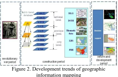
Generally, in the end of 21 century, the actual demand of mapping and geographic information services for our economy and society has significant changed. To the end of the last century, despite the needs of mapping and geographic information for economic and social development has been changing, but in essence still the basic map for the main demand product. Figure2 shows analysis of demand trends of China's geographic information mapping.
Figure 2. Development trends of geographic information mapping
The characteristics of new era of survey and mapping geographic information as follow:
(1)high dynamic. Periodic mapping and geographic information update has unable meet requirements. (2) global. New era of economic and social development in all areas propose new and higher demands to the work of mapping geographic information should reach heaven, into the earth, sea and teng pole.
(3)comprehensive. Seven elements of data services has been far from satisfying the requirements of comprehensive monitoring and analysis, so, it is necessary to provides a comprehensive geographic information services to meet the urgent needs of the task.
4.2 Technology promote dramatically change
Mapping technology is always an important impetus for the development of geography information. First, the vigorous development of space technology for the geographic information mapping has opened up broad prospects. According to national development planning, " Twelfth five" period, the state will achieve the Beidou satellite positioning system to cover the target region, in terms of remote sensing satellites will further increase investment for the weather, ocean, land resources, environmental mitigation, mapping and other needs, planning to launch low, medium and high-resolution earth observation satellites. And now, there are already nine satellites, remote sensing satellites in orbit desire to over 20 in 2015.
Second, geographic information mapping modernization of production facilities, information technology, production gradually to meet the service system as "monitoring" real-time, process automation, network services. And, the series of national scale-based geographic information database has established. Third, the rapidly development of network technology and network infrastructure enhanced the capabilities of geographic information security services, promoting applications for the next step to update the base mapping and geographical information service-oriented transformation.
5. HOW TO REALIZE NATIONAL GEOGRAPHICAL SITUATION MONITORING
IN CHINA?
There are four items to facilitate monitoring geographical conditions normalization and standardization:
First, the technical system of surveying and mapping production should be transformed from digital mapping to information mapping, and ultimately International Archives of the Photogrammetry, Remote Sensing and Spatial Information Sciences, Volume XXXIX-B4, 2012
XXII ISPRS Congress, 25 August – 01 September 2012, Melbourne, Australia
achieve data acquisition real-time, processing automation and service network.
Second, the content of surveying and mapping production should be transformed from primary to provide baseline data, the basic scale topographic maps and data-based geographic information to the dynamic, real-time, on-demand geographic information.
Third, the services organization system of surveying and mapping should be transformed from meeting analog and digital time period mapping agencies to meeting information mapping agencies.
Among them, the transformation of production services technology system for the monitoring of the geographical conditions provide a technical guarantee; and production services to the transformation of the organization was monitoring the geographical conditions of protection provided by the organization. 5.1 Promote the integration of industrialization and the depth of the road information in surveying the field of geographic information
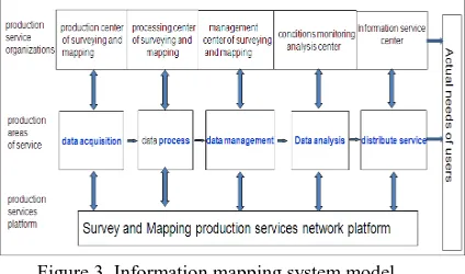
During the period of industrial, the workflow of surveying and mapping formation drawing, printing and other processes, approaching both standardized production of basic features and pursuit efficiency. Figure3 shows the mapping information system model, which will be established in 2015 for national geography condition monitoring.
Figure 3. Information mapping system model 5.2 Adjust the structure of production teams to promote the efficiency and ability of surveying and mapping production
Talent is the main wisdom and strength in implementation national geography conditions monitor work. Due to the scope and content of traditional survey and mapping work has been greatly expanded by national geographical condition monitor. So, the demand for surveying and mapping professionals are growing rapidly. It is necessary to promote nationwide mapping geographic information department to the optimal layout.
5.3 Form division of labor and cooperation relationship between mapping geographic information sector and other sectors
It is necessary to establish coordination mechanisms between Geographical conditions to carry out monitoring work, the establishment of departments, especially between mapping and geographic information sector development and reform departments, resources and environment sector,
economic cooperation between statistical authorities and other coordination mechanisms.
First, make a better understanding of mapping geographic information sector monitoring needs of other departments, so that the targeted monitoring. Second, unified technical standards will establish to monitor the geographical conditions and specifications. Third, the results on the monitoring form, publishing issues such as communication and coordination methods.
REFERENCE
[1]National Administration of Surveying, Mapping and Geoinformation(SBSM),2002.The people's Republic of China Surveying and Mapping Law, Beijing, PRC.
[2] QIAN,XS, 1991. On the Content and Method of Research of Geography Science Journal of Geographical Sciences, 46(3) , pp. 257-265.
[3] WANG JF, 1995. Man Land Relationship and Its Regulation, Science Press, Beijing, pp. 11-23. [4]CHENG JC, 1995. Introduction to Digital Earth, Science Press, Beijing, pp. 201-221.
[5] LI DR, SHAO ZF, 2009. On the new geographic information era. Science in China, 39(6), pp.579-587. [6]National Development and Reform Commission(NDRC), 2006. Economic and Social Development in the Eleventh Five Year Plan , Beijing, PRC.
[7]National Development and Reform Commission(NDRC), 2011. Economic and Social Development in the Twelfth Five Year Plan , Beijing, PRC.
International Archives of the Photogrammetry, Remote Sensing and Spatial Information Sciences, Volume XXXIX-B4, 2012 XXII ISPRS Congress, 25 August – 01 September 2012, Melbourne, Australia