INTEGRATION OF HETEROGENOUS DIGITAL SURFACE MODELS
R.Boesch, C.Ginzler
Swiss Federal Institute for Forest, Snow and Landscape Research WSL, Zürcherstr. 111, 8903 Birmensdorf,
Switzerland
{boesch,ginzler}@wsl.ch
Commission IV, WG IV/2
KEY WORDS: Automation DSM/DTM LiDAR National Photogrammetry Resolution Triangulation
ABSTRACT:
The application of extended digital surface models often reveals, that despite an acceptable global accuracy for a given dataset, the local accuracy of the model can vary in a wide range. For high resolution applications which cover the spatial extent of a whole country, this can be a major drawback.
Within the Swiss National Forest Inventory (NFI), two digital surface models are available, one derived from LiDAR point data and the other from aerial images. Automatic photogrammetric image matching with ADS80 aerial infrared images with 25cm and 50cm resolution is used to generate a surface model (ADS-DSM) with 1m resolution covering whole switzerland (approx. 41000 km2). The spatially corresponding LiDAR dataset has a global point density of 0.5 points per m2 and is mainly used in applications as interpolated grid with 2m resolution (LiDAR-DSM).
Although both surface models seem to offer a comparable accuracy from a global view, local analysis shows significant differences. Both datasets have been acquired over several years. Concerning LiDAR-DSM, different flight patterns and inconsistent quality control result in a significantly varying point density. The image acquisition of the ADS-DSM is also stretched over several years and the model generation is hampered by clouds, varying illumination and shadow effects.
Nevertheless many classification and feature extraction applications requiring high resolution data depend on the local accuracy of the used surface model, therefore precise knowledge of the local data quality is essential.
The commercial photogrammetric software NGATE (part of SOCET SET) generates the image based surface model (ADS-DSM) and delivers also a map with figures of merit (FOM) of the matching process for each calculated height pixel. The FOM-map contains matching codes like high slope, excessive shift or low correlation.
For the generation of the LiDAR-DSM only first- and last-pulse data was available. Therefore only the point distribution can be used to derive a local accuracy measure.
For the calculation of a robust point distribution measure, a constrained triangulation of local points (within an area of 100m2) has been implemented using the Open Source project CGAL. The area of each triangle is a measure for the spatial distribution of raw points in this local area.
Combining the FOM-map with the local evaluation of LiDAR points allows an appropriate local accuracy evaluation of both surface models.
The currently implemented strategy ("partial replacement") uses the hypothesis, that the ADS-DSM is superior due to its better global accuracy of 1m. If the local analysis of the FOM-map within the 100m2 area shows significant matching errors, the corresponding area of the triangulated LiDAR points is analyzed. If the point density and distribution is sufficient, the LiDAR-DSM will be used in favor of the ADS-DSM at this location. If the local triangulation reflects low point density or the variance of triangle areas exceeds a threshold, the investigated location will be marked as NODATA area.
In a future implementation ("anisotropic fusion") an anisotropic inverse distance weighting (IDW) will be used, which merges both surface models in the point data space by using FOM-map and local triangulation to derive a quality weight for each of the interpolation points. The "partial replacement" implementation and the "fusion" prototype for the anisotropic IDW make use of the Open Source projects CGAL (Computational Geometry Algorithms Library), GDAL (Geospatial Data Abstraction Library) and OpenCV (Open Source Computer Vision).
1. INTRODUCTION
Digital surface and terrain models are important for assessment and modeling within most landscape applications. The canopy
quality of DSM and DTM defines the application potential. The assessment of local variation will be also important when digital surface models will be combined.
Within the Swiss National Forest Inventory (NFI), two digital surface models are available, one derived from LiDAR point data and the other from digital aerial images. Point data and images have been produced by the Swiss Federal Office of Topography (Swisstopo) and are covering whole Switzerland (approx. 41'000 km2). Different applications for forestry and landscape analysis require a high quality of the surface model. Especially for stand area estimation, habitat analysis and landscape modeling local accuracy is crucial for detailed and reliable results within an inventory process. But due to long acquisition time, varying illumination and different processing environments, both digital surface models are not homogenous on a high resolution scale.
Therefore the goal of a combination of different surface model is mainly to reduce local quality problems and to generate an improved dataset.
2. LIDAR DATA
The LiDAR point data has been acquired between 2000 and 2006 and has an official average point density of 0.5 points/m2 with a vertical accuracy of +/- 0.5 m in open areas and +/- 1.5 m in terrain with vegetation (Artuso, Bovet et al. 2003). Above 2000m no acquisition has been done due to financial and operational restrictions. The dataset will be used as point cloud (LiDAR-DSM) and as interpolated grid with 2m resolution (LiDAR-DSMGrid).
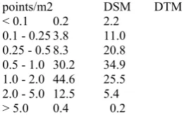
To estimate effective local accuracy the point density in a 10x10m local neighborhood has been calculated.
points/m2 DSM DTM
Table 1 . Percentage of LiDAR-DSM and -DTM points within a 10x10m neighborhood:
Table 1 reveals that national datasets are not so homogeneous as average density estimates may suggest. The 12 % area of DSM points which have less than 0.5 points/m2 demonstrates, that about 5000 km2 have an insufficient point density for most applications. Different acquisition and processing methods, varying acquisition time schedules and inconsistent quality control are the main reason for partially poor point density.
3. IMAGE DATA
Mainly due to this extended accuracy problems and because high resolution aerial imagery in visible and infrared channels is available for whole Switzerland and within a shorter acquisition time frame, the calculation of a new stereo-based surface model based on infrared images has been established (Ginzler, Boesch et al. 2011).
Automatic photogrammetric image matching of ADS80 aerial infrared image stripes with 25cm resolution, 50cm in mountain regions allows to achieve a higher output dataset resolution compared with LiDAR, offers homogeneous and calibrated image data for the whole country and provides an operational image acquisition schedule every 3 years.
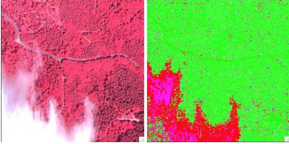
Fig 1 and 3 show two typical sample areas (500x500m) from flat and hilly regions in Switzerland. The commercial software package NGATE from BAE-Systems (Devenecia, Walker et al. 1996) is used to generate a surface model (ADS-DSM) with 1m resolution covering whole Switzerland.
The image acquisition time of 3 years for the calculation of the ADS-DSM is short enough for most landscape and forest applications, but spectral image quality is still influenced by clouds, varying illumination and saturation effects. Due to the use of infrared as input for stereo matching, shadow problems are reduced significantly compared to the common processing of RGB data, but steep terrain, clouds and water surfaces remain as primary sources of stereo matching problems (Fig 5 and 7).
Figure 1 ADS80 CIR "flat" Figure 2 FOM-map "flat"
Figure 3 ADS80 CIR "hilly" Figure 4 FOM-map "hilly"
During the generation of the ADS-DSM, NGATE delivers also a map with figures of merit (FOM) of the matching process for each calculated height pixel. This FOM-map contains different codes, which correspond to the successful correlation value (green) or detailed error codes, indicating high slope, excessive shift or low correlation (red). Classification of the error codes demonstrates a simplified FOM-map in Fig 2 and 4.
4. FUSION STRATEGIES
DSM is a feasible strategy to overcome local accuracy defi-ciencies.
The integration or fusion of digital surface model is a long standing issue in GIS and remote sensing and very different
approaches have been selected (Eckstein and C. 1996; Buckley and Mitchell 2004; Karkee, Steward et al. 2008; Li, Chen et al. 2010).
Figure 5 ADS80 CIR "alpine" Figure 6 NGATE FOM-map"alpine"
Figure 7 ADS80 CIR "cloud" Figure 8 NGATE FOM-map"cloud"
5. IMPLEMENTATION
We implemented a fusion-strategy "partial replacement" based on the hypothesis, that the ADS-DSM is superior due to its regular sampling with a spatial resolution of 1m. The FOM-maps in Fig 6 and 8 show two sample areas with significant matching errors (red).
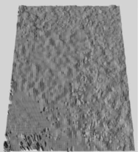
Figure 9 NGATE FOM processing errors "cloud" Figure 10 DOM-DSM density "cloud"
significant processing error regions (Fig 9). Small error areas (Fig 2,4) are therefore ignored and therefore the ADS-DSM will be used. In the case of significant error regions (Fig 6 and 8), the corresponding area of the LiDAR-DSM point cloud is analyzed. To estimate the density and spatial distribution of the single points, a local triangulation within a 10x10m bucket area is performed (Fig 10). The classification of point density in Fig 10 reveals a sufficient density for the area sample "cloud":
green >= 0.5 p/m2
dark green >= 2 p/m2
If density and spatial distribution of the points are above application-defined threshold values, the interpolated LiDAR-DSMGrid will be used in favor of the ADS-DSM at this 10x10m bucket area. If the point density is too low or the distribution measure indicates clumped point data, the investigated bucket area will be marked as NODATA area.
Figure 12 Combined ADS- and LiDAR-DSM "cloud" (oblique view)
The processing errors of Fig 9 define the replacement mask, which allows to generate the completed fused DSM (Fig 12 and 13 represent the dashed area of Fig 8 as enlarged oblique view).
In comparison with the original ADS-DSM (Fig 13), the partial replacement removes the DSM artifacts in the cloud covered image area. The "salt and pepper" error areas of Fig 8 remain intentionally unchanged.
Figure 13 ADS-DSM "cloud" (oblique view)
6. CONCLUSIONS
Fusion with "partial replacement" allows to merge two heterogenous surface models with a systematic approach based on statistical quality measures. If both dataset show significant errors at the same location, a local fusion seems to be appropriate. In a future implementation ("anisotropic fusion") an anisotropic inverse distance weighting (IDW) will be used, which merges both surface models in the point data space by using FOM-map and local triangulation to derive a quality weight for each of the interpolation points.
7. REFERENCES
Verification of countrywide Terrain and Surface Models. International Archives of Photogrammetry and Remote Sensing, vol. XXXIV-3/W13.
Boesch, R., C. Ginzler, et al. (2010). Robust canopy matching using local shape analysis. ForestSat Congress 2010, Lugo. Buckley, S. J. and H. L. Mitchell (2004). "Integration, validation and point spacing optimisation of digital elevation models." Photogrammetric Record 19(108): 277.
CGAL. "Computational Geometry Algorithms Library." from http://www.cgal.org.
Devenecia, K., S. Walker, et al. (1996). New Approaches to Generating and Processing High Resolution Elevation Data with Imagery. Photogrammetric Week.
Eckstein, W. and S. C. (1996). Fusion of Digital Terrain Models and Texture For Object Extraction. Second International Airborne Remote Sensing Conference and Exhibition, Mountain View. California.
GDAL. "Geospatial Data Abstraction Library." from http://www.gdal.org.
Ginzler, C., R. Boesch, et al. (2011). High resolution digital surface models for forest monitoring, a photogrammetric approach for large areas. 1st Forestry Workshop: Operational Remote Sensing in Forest Management, Czech Technical University (CTU), Czech Republic, Prague.
Karkee, M., B. L. Steward, et al. (2008). "Improving quality of public domain digital elevation models through data fusion." Biosystems Engineering 101(3): 293-305.
Leyk, S., R. Boesch, et al. (2006). "Saliency and semantic processing: Extracting forest cover from historical topographic maps." Pattern Recognition 39(5): 953-968.
Li, H. Y., S. B. Chen, et al. (2010). "Fusion of Lidar Data and Orthoimage for Automatic Building Reconstruction." 2010 IEEE International Geoscience and Remote Sensing Symposium: 1194-1197.
OpenCV. "Open Source Computer Vision." from http://op-encv.willowgarage.com/wiki/.