(laser scanner, photogrammetric, topographic and traditional direct), rather than those relating to the interpretation of the data. Yet in the methods of traditional representation, the data interpretation, such as that of the philological reconstruction, constitutes the most !
In the case study of the Abbey of Casamari (Veroli), one of the most important Cistercian settlement in Italy, the survey made for an Agreement with the Ministry of Cultural Heritage and Activities and Tourism (MiBACT) and University of RomaTre, within the project “Accessment of the sismic safety of the state museum”, the reference 3D model, consisting of the superposition and geo-referenced data from various surveys, is the tool with which to develop representative models comparable to traditional ones. It related to phases of construction, state of deterioration and structural features.
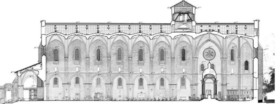
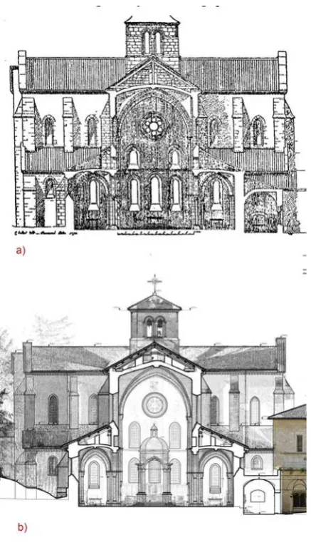
Figure 1a. The Abbey of Casamari (Veroli): Longitudinal section, Survey elaboration (2014)
Figure 1b."#$ %& '+/ 5%6789'
1. INTRODUCTION
In an architectural survey aimed at the preservation or restoration of a structure, such as the Abbey of Casamari “the simple geometrical knowledge - morphological aspects of a building ; correctness of further interventions on it” (Docci - Maestri, 2009, p. 7).
Whilst drawing survey is the basic support for the analysis > elements that are subject to such analysis, starting from those of Constructive and Stratigraphic Survey (Harris, 1975; Francovich - Parenti, 1978) and Critical Survey (Francovich, 1985; Brogiolo, 1991; Carbonara, 1985; Doglioni - Gabbiani, 1985; Parenti, 1985). For that purpose, the drawings should be able to describe all the characteristic features of the building, in addition to numeric and dimensional ones: the masonry layers, the characteristics and the material properties, the working and installation, the construction
Figure 1c. The Abbey of Casamari (Veroli): Longitudinal section, Elaboration by C. Enlart (1894)
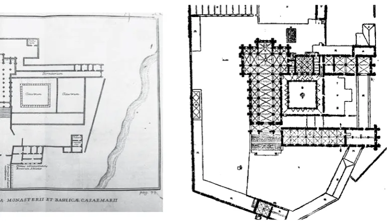
Figure 2b. Plan of C. Enlart (1894) Figure 2a. Plan of F. Rondinini (1207)
details, architectural anomalies and the building phases etc. This process, in order to be it as much empathy with the surveyed bject (Bertocci - Bini, 2012, p.317), it is necessary that the scholar of an architectural work, should devote a special attention to matching survey – object, in his dual role of surveyor and renderer, guaranteed only by a direct contact with the architectural N O O In view of these considerations, survey drawings (Figure 1a) must relate, both to survey numeric data, represented, for example, 5 %Q 8' documentation (Figures 1c), such as the drawing by C. Enlart (1894), which constitutes not only a useful point of comparison > survey graphics processing should refer.
2. THE CASAMARI’S ABBEY AT VEROLI The object of study, which is the complex of the Casamari’s Abbey, is a test case where to apply a survey methodology that takes into account both the morphological aspects as those constructive and transformative ones. The complex, located near the town of Veroli (Lazio) and composed by various buildings (including the church, the cloister, the museum, the refectory, the dormitory) spread over a large area (about 26,600 m2), it is one of most important examples of Cistercian architecture in Italy.
Figure 2d. Survey Plan (2014)
2.1 Study about historical documentation
Based on the literature on the Abbey, especially (Rondinini, 1707; Enlart, 1894; Scaccia Scarafoni, 1962; Farina and Fornari, 1978; Picuti, 2008), the iconographic documentation, including the plan of the Gregorian Catasto, 1824, and previous surveys, made during the recent restorations by the Superintendency, it can # Z monks around the 1036, on the ruins of an ancient Roman settlement, was restored by the Cistercian monks between 1151 868[# N8\7> Figure 2c. Plan by Picuti (2008)
fell into a state of progressive decay and abandonment. Some limited restoration works have been made in the mid-sixteenth century and other most important, in the early eighteenth century, rose again the fate of the Abbey. Throughout the nineteenth and twentieth centuries several restoration projects have been realized, including some hearty in the early 80s and 90s.
2.2 Study and survey on the current status
In 2014 an agreement with the Ministry of Cultural Heritage and Activities and Tourism (MiBACT) and University of Roma Tre, within the project “Accessment of the seismic safety of the state museum”, has allowed to develop a detailed study about the $ ]# ^ such as Building Science, Representation and Restoration (1). In this context a survey campaign of the entire complex was made
(2)^ >
8" N +_Q%`q and Coordinator of Investigation and structural Analysis), M. Canciani (Coordinator of geometrical and architectural Survey), M. Zampilli
(Canciani - Spadafora, 2014). The work was developed in four ^ +
a. An initial phase of cartographic framework _ according to a documentation and previously carried out surveys.
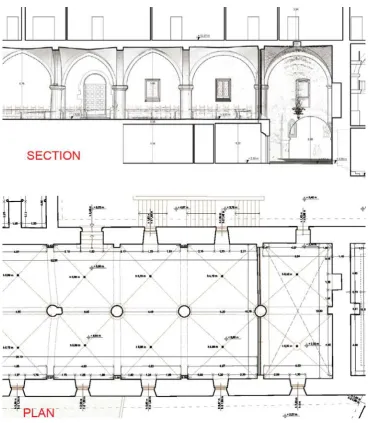
b. A second phase of collecting data on site realized through various integrated procedures: topographic framing survey (20 stations and 8200 points); 3D laser scanner survey (72 stations and 1,896,000,000 points); photogrammetric survey (1500 photos and 56 models); Direct survey (various measurements and processing of general and detailed hand drawings).
c. A third phase of data into three-dimensional models processing %}7 modeling and analysis).
# + 9 8+677%5 '~8[ partial plants in scale 1: 100 (church, museum refectory, cloister, ;'~8+877
(Coordinator of historical-critical Survey and constructive Survey)
Figure 4a. Detail of the Plan of the church
Figure 4b. Cross section, looking at the church counterfaçade
(from A-A’ section to H-H’ section); 4 elevations in scale 1: 100 (North South East, West)(3).
2.3 Analysis and comparison
On the basis of the survey drawings, comparing them with historical documents it was possible to carry out some analysis + ' ' ' ^
# 88\8868[ by the map shown in (Rondinini F. 1707) (Figure 2a), develops according to a typical type of Cistercian settlements (also taken in the Abbey of Fossanova, coeval with that of Casamari and made Z N '~ $ which other buildings are located: _ the Basilica to the north, the Dormitorium to the east a second Claustrum, south a building in West; the Abbot’s residence disposed on the perimeter wall above the entrance of the complex. On the next map on the Gregorian Cadastre of 1824 and shown in (Enlart C. 1894) (Figure 2b) it
2 The work group for geometrical and architectural Survey is composed by: M. Canciani (Coordinator), S. Tagliati, A. Ballanti, B. Mammì, M. Michelini, G. Romito, A. Scortecci, S. Strambone
Figure 5a, b. Refectory: Longitudinal Section and Plan
with the addition of a building located on the southern front which completes the second cloister built around and some perimeter warehouses. The projection of the intrados of the roof in the including the church, the chapter house, refectory, covered by cross vaults and cloister, covered by a vault with lunettes. By comparison with the plan by Picuti (2008) (Figure 2c) and survey plan of 2014 (Figure 2d) it shows that the current > above now no longer present (on the facade of the museum it is possible to see the traces of the two covering layers of the disappeared building, which stood against the wall) and the addition of new volumes (new sacristy, kitchen etc.). The drawing of site plan scale 1: 200 uses a symbology and a descriptive level that is related to that one of the Enlart drawing.
b) Analysis of the constructive aspects and details
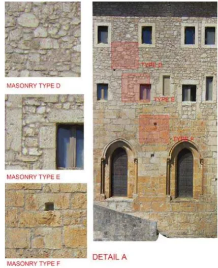
" resolution allows a precise and detailed reading of the wall texture, provided the basis for the analysis of the constructive aspects, the masonry stratigraphy and typologies.
the side doors a masonry (Figure 3a, Type B), consisting of large ! ^ coming from the counting of pre-existing Roman structures chronologically contiguous.
Even the entrance portal is due to a later phase than that of the wall, being the portal framing set against the vault of the narthex (Figure 3a, masonry Type A).
Looking at the Eastern front of complex the variations of wall texture and discontinuities, it is possible to hypothesize a + place to the left and the new sacristy to the right (Figure 3b, Type Q' > to read the transformations that occurred at the open in breach ^ to a contemporary phase (Figure 3b, Type E).
c) An accurate analysis of the current state, as elaborated by the survey graphics compared with historical documents it allows to highlight certain anomalies and deviations from the ideal geometric conformation, useful for understanding the changes that occurred and previous or current alterations.
In particular, concerning the church, in the drawing of the plant are obvious that the projections of the ribs of the voults do not have a linear path but curvilinear (Figure 4a); the projection of the vaults is not placed vertically respect the base of the south wall pillars and this misalignment is also evident in cross section (Figure 4b). In longitudinal and cross section it is still denotes a marked inclination of the intermediate moulding that denouncing ^ construction.
Regarding the bell tower the comparison between the current section of the four-pitched roof covering and the view of Rondinini highlight an original conformation of a more inclined roof. In the section shown by Enlart (1894) the roof is drawn as it is in its present state, but the drawing in broken lines shows a
1890, was rebuilt at that period (Figures 1a and 1c).
Regarding the refectory is evident in the fourth column from the left, a support place as a further backing of vault in correspondence of which in plan is pronounced denotes a shift of the ribs. In the Enlart plan, the refectory has 8 spans and is directly connected with the library (Figure 5a), while in the plan derived from the current survey, set in 7 spans and the 8th corresponds to a space with double height with the masonry of the vault to view and corresponding to the entrance passage to the monastery (built so at a later date to 1894) (Figure 5b).
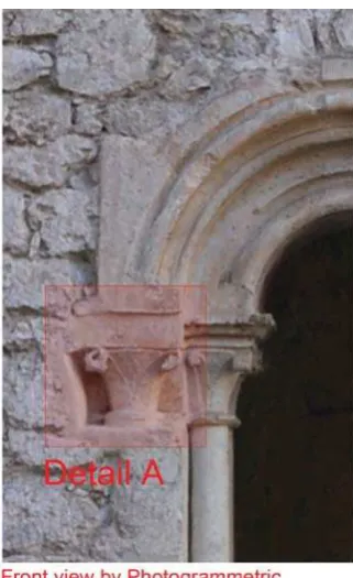
About the cloister, comparing the plan of Rondinini with that one of Enlart, it can observe the transformation occurs in a period between 1707 and 1894 in which, for a continuous series of attached bifore, it follows a series of bifore separated by little walls just as it is in its present state. The detailed survey made it the left of the western side of the cloister has three capitals: two on the lower inside arch and one on the upper outside arch (Figure }'" > at present.
3. CONCLUSION
This paper shows only partially the potential that a survey method specializing in the architectural, morphological or constructive studies, can make to the knowledge and understanding of a building complex as well articulated as the Abbey of Casamari. The huge amount of data organized according to a geospatial reference system allows to select some portions of them on the basis of the section planes used in historical designs in order to make a congruent superposition so as to reveal anomalies and ^ %Q [ ' section, it is possible to see, both in the central nave and in the lateral ones, the supporting structures of the roof trusses, built after 1894 (not visible in the Enlart drawing), and placed on the kidneys of the voults.
Figure 6. Detail of the Cloister
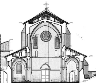
Figure 7. a) Cross section by Enlart (1894); b) Cross section by Survey (2014)
REFERENCES
Aliberti, L., Canciani, M., Alonso Rodriguéz, M. A., 2015. New contributions on the dome of the Pantheon in Rome: comparison between the ideal model and the survey model. In: International Archives of the Photogrammetry, Remote Sensing and Spatial
Information Sciences, vol. xl-5/w4, p. 291-297
Bertocci S. and Bini M., Manuale di rilievo architettonico e
urbano, Città studi edizioni, Novara 2012.
$` _6789^ ! nel rilevamento 3D, in archeologia e in architettura. In: ITALIAN
SURVEY & INTERNATIONAL EXPERIENCE, Gangemi, Roma,
p. 777-783
Canciani, M., Cennicola, V., Messi, M., Saccone, M., Zampilli, M., 2013. A 3d Gis Method applied to Cataloging and Restoring: the case of Aurelian Walls at Rome. In: XXIV International CIPA Symposium. INTERNATIONAL ARCHIVES OF THE PHOTOGRAMMETRY, REMOTE SENSING AND SPATIAL
INFORMATION SCIENCES, Strasbourg, France.
Canciani, M. and Saccone, M., 2011. The use of 3d models in integrated survey: the Church of St. Thomas of Villanova in Castel Gandolfo. In: Proceedings of the 4th ISPRS
International Workshop 3D-ARCH 2011. ISPRS JOURNAL
Farina F. and Fornari B., 1978, L’architettura cistercense e
l’abbazia di Casamari, Edizioni Casamari, Casamari, (2° ed.
1981)
Francovich R., Parenti R., (ed.), 1988, Archeologia e restauro
dei monumenti, Ciclo di lezioni sulla ricerca applicata
all’archeologia, Certosa di Pontignano (Siena), 28 settembre –
10 ottobre.
Harris E.C., 1979, Principles of archaeological stratigraphy, London.
Marino, L., 1990, Il rilievo per il restauro: ricognizioni,
misurazioni, accertamenti, restituzioni, elaborazioni. – Milano,
Hoepli.
Picuti M.R., 2006, Nuove ricerche su Cereatae Marianae (Casamari, Frosinone), in Ghini G., a cura di, In “Lazio e Sabina,
3, Atti del Convegno, Roma, 18-20 novembre 2004”, Roma, pp.
297-304.
Picuti M.R., 2008, Museo dell’Abbazia di Casamari. La raccolta
archeologica, Edizioni Casamari, Veroli.
Rondinini F., 1707, Monasterii sanctae Mariae et sanctorum
Johannis et Pauli de Casaemario brevis historia, Roma.