APLICATION OF ANALYTICAL HIERARCHY PROCESS (AHP)
FOR LAND USE ALLOCATION
By:
Rahmawaty
a Department of Forestry, Faculty of Agriculture, Sumatera Utara University, Jl. Tri Dharma Ujung No. 1 Kampus USU, Medan, 20155, North Sumatra, Indonesia
email:
Abstract
This study was conducted to develop a framework for participatory and improved land use decision-making in Besitang Watershed, Langkat, North Sumatra, Indonesia. Specifically, it aimed to determine the best land use allocation using AHP. Collective opinion was derived from the workshop with stakeholders. Alternative for forestry in Besitang Watershed based on integrated approach has very high suitability (63%). Agriculture use has high (63%) to very high (37%) suitability. Settlement area has low (23%) to moderate (77%) suitability. Fishery use has low (47%), moderate (18%), and high (35%) suitability. Industry has very low suitability in all decision zones (100%). Based on allocation for multiple-use, Besitang Watershed has very high potential suitability for forestry (63%) and agriculture (37%) land uses. The most significant contributions of this study in facilitating land use decision-making were: as a tool for land use allocation and policy formulation, as well as for scientific investigations. This approach provides participatory involvement of stakeholders in land use allocation.
1. Introduction
The increasing human population, the more consequent accelerating demands and intensity of human activities on the land have various degrees of impact on all of the material and natural resources in the world. Human population pressures have accelerated the increases of land value and the diversity of land use. Land is becoming scarce so that the more fragile upland areas are looked upon as the last frontier for the expansion of agriculture and other land uses. As a result, numerous problems have now been threatening the ecological stability of much upland (Cruz, 1990).
At the moment, there is a trend to make use of the land for the economic interests, which could increase the income. One of the favorite and high-economic-value plants in this area is oil palm. Another problem in Besitang Watershed that seems to be a major one is land conversion to oil palm plantation and fish pond in the mangrove forests by the surrounding community have decreased the size of the available area. According to Ekanayake and Dayawansa (2003), land as resource cannot be measured by the surface area alone; hence the types of soil which is critical for productivity, underlying geology, topography, hydrology, and plants and animal population also has to be considered. These attributes limit the extent of land available for various purposes. The growing population, industrialization and misuse and overexploitation of land resources have in effect increased the demand for land.
Changes in the use of land occurring at various spatial levels and periods can have either beneficial or detrimental effects. The latter is the main concern of decision-makers because of its effect on the population and the environment. The goal of managing land use and its change is to develop the land resources in ways that capitalize on the local potential and suitability, avoid negative impacts and respond to present and future societal demand within the limits of the carrying capacity of the natural environment (FAO, 1995). Decision support system has been identified as a critical component to identify and solve problems, provide information and current scientific knowledge in watershed management decision making process.
Based on the Besitang Watershed’s condition, some thoughts on good steps or actions are needed to overcome these problems. Rehabilitation of watersheds is also needed so that it can support and enhance other environment functions. At present, researches on land use and land use planning have been carried out in the area but these have not fully looked into the driving forces of land use as influenced by renovation policies. There is a need of an approach that can involve the participation of stakeholders so that land use management planning can be effectively and efficiently done in accordance with Republic of Indonesia Law Number 26 (2007) about Spatial Management. The research about land use allocation with stakeholder participation and collaboration that is crucial for successful and sustainable watershed management has never been conducted previously in the area. For this reason, it is essential that research in this area be conducted.
This study generally aimed to develop a framework of participatory and improved land use decision-making in Besitang Watershed, Langkat, North Sumatra, Indonesia. Specifically, the study aimed to determine the current and potential land use suitability in the area with stakeholder participation and to develop a spatial participatory land use allocation for the area.
2.1. Description of the Study Area
The study was conducted in the Besitang Watershed, from April to August 2008. Administratively, the study area lies in the Langkat Regency, North Sumatra Province, Indonesia. It consists of five sub-districts, namely: Besitang, Barandan Barat, Padang Tualang, Pangkalan Susu, and Sei Lepan.
Besitang Watershed has an area of 100,035 ha excluding the islands. In the border of Malaka Strait in the East, there are islands that have an area of 5,089 ha. Geographically, it is located between 97o 50’ 00” to 98o 20’ 00” east longitude and 03o45’ 00” to 04o15’ 20” north latitude. It is bordered by the Province of Nangroe Aceh Darussalam in the North, Sei Lepan Watershed in the South, Malaka Strait in the East, and the Province of Nangroe Aceh Darussalam in the West.
2.2. Data Collection
2.2.1. Collective Opinion Information
Information for collective opinion was gathered from primary data (interviews during field survey and during the workshop). The workshop was conducted to determine land use suitability allocation based on public opinion from stakeholder using AHP. The study largely relied on the use of questionnaire and key informant/stakeholder. Key informants/stakeholders provided qualitative in-depth information about physical and socio-economic conditions of the study area. Key informants/stakeholders were local officers, extension workers, teachers, researchers, and people who know well the study sites at provincial, regional, sub-regional, and village level. Secondary data were collected from offices which are related to the study.
2.2.2. Potential Land Use Suitability Classification and Land Use Allocation
The collective opinion was used based on AHP as a tool and used Expert Choice as software. The AHP utilizes the system approach to decision making. The recommended procedure to solve a problem using the AHP method based on the AHP principles is as follow:
1. Structuring the Problem into a Hierarchy
In this study, generating the integrated measure (the first step in the AHP) was to define the hierarchy, each representing a level in the system. Three identified levels of hierarchy in the area are shown in Figure 1.
Figure 1. Hierarchical levels for decision-making in AHP model
The best land use allocation
Forestry Agriculture Settlement Industry Fishery
Level 1 Goal
Level 2 Objectives
2. Comparing the Hierarchy Elements on a Pairwise Base
Based on the hierarchy levels, then the questionnaire was done and the respondents were filled during the workshop. Preference is denoted by a vector of weights following and AHP scale of relative importance ranging from 1 to 9 (Saaty, 1980). The pairwise comparison matrix (PCM) is a reciprocal matrix in which elements under its main diagonal are inverses of the upper elements. If there are n elements to be compared, which form an n x n PCM, then there was n(n-1)/2 pairwise comparisons in a PCM. In this study there were four elements for objectives and five elements for alternatives to be compared, then there were be six pairwise comparisons for objective and ten pairwise comparisons for alternatives in a PCM.
In this study, in order to make informed and valid assessments, the area was divided into zone with relatively homogenous characteristics. The analysis was preceded by conducting a pairwise comparison of the objectives. Each decisionmaker was asked independently to establish the relationship among the objectives using the ratio scale of measurement. For each decisonmaker, therefore, a square objectives matrix was generated, then, the matrices were normalized. This was processed in Expert Choice Program. Central to AHP is a measure of consistency in human judgments. According to Malczewski (1999) if consistency ratio (CR) is less than 0.1, there is a reasonable level of consistency in the pair-wise comparisons. If CR is more than or equal 0.1, the values of the ratio are inconsistent. In the latter case, the original value in the pair wise comparison matrix should be revised. Consistency measurement was be done by using Expert Choice Program.
3. Aggregating All Priority Vectors
The final step was to aggregate the priority (weight) vectors of each level obtained in the second step, to produce overall weights. This was processed in Expert Choice Program.
The land use allocation was derived from the results of the potential land use suitability based on integrated approach. In this study, land use allocation was adopted from Bantayan (2006). The classification procedure puts the alternatives in classes signifying the degree of suitability of a particular alternative to the land units. The land use suitability classification in this study was categorized as follows: very high suitability (S1), high suitability (S2), moderate (S3), low suitability (S4), and very low suitability (S5). These were expressed as relative weight of alternatives by decision zone. Based on these priorities, the degrees of preference for the major land use groups can be expressed as degrees of land use suitability for each decision zone.
In this study, land use allocation used two kinds of land use allocation that was adopted from Bantayan (2006), namely: allocation for single use and allocation for multiple-use. Land use allocation for single use, the process of allocation depends on whether or not the results of the land use suitability classification are regarded in absolute terms. A process of exclusion is implemented where only the alternative that receives the highest suitability is chosen for allocation and the rest are excluded in regard to the land units in question. Land use allocation for multiple-use, an alternative approach is to recognise the gradation in the suitability classification. It can be accomplished by concurrent and continuous use of several natural resource products obtainable on a particular land unit requiring the production of several goods and services from the same area.
3. Results and Discussions
Land system is based on Regional Physical Planning Programme for Transmigration (RePPProT) survey in 1980 and still being used. Basic concept of land system is to divide the landscape into areas meaningful for development planning. The land concept is based on ecological principles and presumes closely interdependent links between rock types, hydroclimatology, land form, soils and organism. The same land system is recognized wherever the same combination of such ecological or environmental factors occurs. A land system therefore, is not unique to one locality only, but considers all areas having the same environmental properties. Furthermore, because a land system consists always of the same combination of rocks, soil and topography it has the same potential, and limitation, wherever it occurs.
In Besitang Watershed, there are eight land systems. Majority land system in Besitang Watershed is Teweh (50%), followed by Maput (16%), Bukit Pandan (13%), Kajapah (13%), Mantalat (3%), Kahayan (2%), and Pendreh (3.%). Only 0.02% is Air Hitam Kanan. The land system is used as a basis to determine decision zone (DZ) in this study. Decision Zone 1 is located in Bukit Pandan and Air Hitam Kanan Land Systems, Decision Zone 2 is located in Pendreh Land System, Decision Zones 3, 5, and 10 are located in Maput Land System, Decision Zones 4, 6, and 11 are located in Teweh Land System, Decision Zones 7 and 8 are located in Mantalat Land System, Decision Zone 9 is located in Kahayan Land System, and Decision Zone 12 is located in Kajapah Land System. Based on the explanation above, look that the decision zones areas were different each others and have broad scale. Hence, for detailed information and assessment (planning), need to rearrange the area of decision zone by stakeholder participation considering the interaction among land uses (ecological interaction).
3.3. Potential Land Use Suitability Classification and Land Use Allocation
Primary data were collected from interviews during field survey and during the workshop. Secondary data were collected from offices which are related to the study. Data and thematic layers needed as supporting data and as guide for stakeholders to fill the questionnaire during the workshop.
A workshop with the stakeholders was conducted for AHP on July 31, 2008 in University of Sumatera Utara, Medan, North Sumatra, Indonesia. The participant is the stakeholder from provincial level, regional level, sub-regional level, and village level. The participants came from different occupations and institutions. Before conducting the workshop, interviewed with some stakeholders that were selected from 100 respondents during gathered data for socio-economic was done to determine several choices for objectives and alternatives. Then, the stakeholders were invited in the workshop as an expert in the area. The group agreed with four of objectives and five of alternatives for potential land use allocation in Besitang Watershed, during the workshop. The objectives were: 1) Environment and conservation, 2) Education and research, 3) Employment, 4) Socio-economic development and the alternatives were: 1) Forestry, 2) Agriculture, 3) Settlement, 4) Industry, and 5) Fishery. Supporting data such as: socio-economic, soil erosion, land classification, and secondary data (Langkat administrative map, watershed boundary map, land system map, soil depth, and soil erosion map) were shown to respondents during the workshop.
(KEL) and the Gunung Leuser National Park (TNGL) and Besitang Watershed as one of the Priority II watersheds in Indonesia (it means that it is in a moderately to severely damaged class). Hence, the areas need special management to maintain the watersheds ecosystem. In related with land use changes assessment, this area has the large portion of forest change from 1990 to 2006. Decrease of forest area will affect the environment in this area. As we know that forest is a system that has some functions, such as: nutrient cycles, water or hydrologic cycles, succession and forest regeneration, wildlife-habitat interactions, and photosynthesis. If any one of these systems breaks down, the forest will not function as it should. According to Perschel et al. (2007), forest has an important role in mitigating climate change by naturally taking carbon out of the atmosphere. Forest preservation maintains carbon storage and forest management that increases carbon
sequestration can augment forests’ natural carbon storage capacity in working forest. In
addition, based on estimate soil erosion and analysis land capability and suitability in this area, conservation needed to reduce soil erosion to ensure sustainability in this area.
This area has very good potential for research and educated activity because in this area there is nature reserve forest. The area was also a potential to employment especially in agriculture because in this area there are big areas for agriculture and
plantation. Also, majority of the people work as farmers’. Socio-economic development is important to achieve human welfare in this area.
In terms of potential land use suitability in Besitang Watershed, the area was classified by five alternative land uses, namely:
1. Forestry. The area that is suitable for forestry and will be used for forestry activities, such as: protected forest, nature reserve, limited production forest, and production forest. 2. Agriculture. The area that is suitable for agriculture and will be used for agriculture activities area, such as: plantation, dry land agriculture, and wetland agriculture.
3. Settlement. The area that is suitable for settlement and will be used for settlement area. This area has the main agricultural activities including the management of natural resources with the order of the area as a function of the rural settlement, services, government services, social services, and economic activities.
4. Industry. The area that is suitable for industry and will be used for industry activities area, such as: agriculture and fishery industry activity.
5. Fishery. The area that is suitable for fishery and will be used for fishery activities area, such as: fish pond, prawn pond, and salting.
In this study, the workshop was conducted only one day because of time and budget constraints. Some stakeholders brought their laptop during the workshop, so they could fill the AHP questionnaire in Expert Choice Program and the consistency could directly determine. The stakeholders who did not bring the laptop filled the questionnaire manually. Hence, test of consistency was conducted after the workshop was finished. In the end, sixteen sets of data were generated from stakeholders in the workshop.
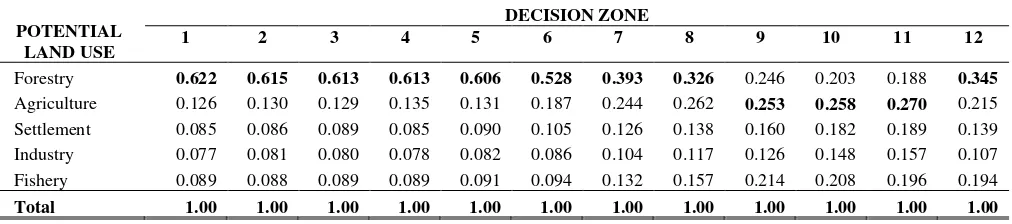
The 16 sets of data were generated from the workshop processed using Expert Choice Program to determine priority of objective for each stakeholder. Furthermore, mixed aggregation of objective used geometric average was derived to represent group judgment. Based on mixed aggregation, the priority objective for all decision zones using mixed aggregation was determined (Table 1). These values are used to establish the priority of alternative for all decision zones (Table 2). The values show the priorities in view of environment and conservation as being majority in this area, followed by education and research, employment, and social economic development.
Table 1. Priority of objective for all decision zones using mixed aggregation
OBJECTIVE DECISION ZONE
Table 2. Priority of alternative for all decision zones using mixed aggregation
POTENTIAL
Based on the result, the first objective in DZ 1 to 9 and DZ 12 was environment and conservation, followed by education and research, employment, and socio-economic development. It means that to achieve the best land use allocation in Besitang Watershed (DZ 1 to 9 and DZ 12), the first priority of objective should be environment and conservation. For DZ 10, the first priority objective to achieve the best land use was education and research, followed by environment and conservation, employment, and socio-economic development. For DZ 11, the first priority objective to achieve the best land use was employment, followed by education and research, socio-economic development, and environment and conservation.
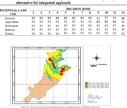
Based on these priorities, the degrees of preference for alternative potential land use in this area can be expressed as degrees of land use suitability for each decision zone. This study is in agreement with Bantayan (1996). The land use suitability classification in this study was categories as following: very high suitability (S1), high suitability (S2), moderate (S3), low suitability (S4), and very low suitability (S5) (Figure 3). Moreover, the relative weight of the alternatives (forestry, agriculture, settlement, industry, and fishery) as shown in Table 3, then is transformed to show the suitability in the context of integrated approach as is shown in Table 3 and depicted in Figure 2.
Table 10. Land suitability classification per decision zone based on priority of alternative for integrated approach
POTENTIAL LAND USE
DECISION ZONE
1 2 3 4 5 6 7 8 9 10 11 12
Forestry S1 S1 S1 S1 S1 S1 S1 S1 S2 S3 S4 S1
Agriculture S2 S2 S2 S2 S2 S2 S2 S2 S1 S1 S1 S2
Settlement S3 S3 S3 S3 S3 S3 S4 S4 S4 S4 S3 S4
Industry S5 S5 S5 S5 S5 S5 S5 S5 S5 S5 S5 S5
Fishery S4 S4 S4 S4 S4 S4 S3 S3 S3 S2 S2 S3
Figure 2. Map of potential land use suitability based on integrated approach in Besitang Watershed
Based on Table 3 and Figure 10, alternative for forestry indicated with the very high suitability (62,814 ha) except for DZ 9 (2,250 ha) (high), DZ 10 (4,757 ha) (moderate), and DZ 11 (30,214 ha) (low). Majority for Agriculture is high suitability (63%) and for DZ 9, 10, and 11 is very high suitability (37,220 ha). Settlement is moderate suitability (76,873 ha) in DZ 1 to 6 and DZ 11 and low suitability (23,162 ha) in DZ 7 to 10 and DZ 12. Fishery is high suitability (34,970 ha) in DZ 10 and 11, moderate suitability (18,405 ha) in DZ 7, 8, 9, and 12 and low suitability (46,659 ha) in DZ 1 to 6. In this area, industry indicated with the very low suitability in all decision zones (100,035 ha).
shall be allocated to the land systems in that particular decision zone. Hence, based on the potential land use suitability classification as is shown in Table 3, the majority land allocation in Besitang Watershed is allocated to the forestry (63%) potential land use (DZ 1 to 8 and DZ 12) followed by agriculture (37%) potential land use (DZ 9, 10, and 11). Another concept of land use allocation is based on allocation for multiple-use. As explained earlier, an alternative approach is to recognise the gradation in the suitability classification. Such an approach follows the multiple-use concept for land use allocation.
According to Bantayan (2006), the objective of multiple-use management is to manage the natural resources in a manner that maximises the benefits which can be derived. Land use allocation for multiple-uses can be accomplished by concurrent and continuous use of several natural resource products obtainable on a particular land unit requiring the production of several goods and services from the same area. As shown in Table 3, Besitang Watershed has very high potential suitability for forestry (63%) and agriculture (37%) land uses.
4. Conclusions
1. As alternative for forestry, potential land use suitability classification in Besitang Watershed based on integrated approach indicated that most areas have very high suitability. Majority of Agriculture area has high to very high suitability. Settlement area has low to moderate suitability. Fishery area has low to high suitability. In this area, industry has very low suitability in all decision zones.
2. Land allocation in Besitang Watershed using the single use concept indicated that the majority of land is allocated to the forestry potential land use followed by agriculture potential land use. Based on allocation for multiple-use, Besitang Watershed has high potential suitability for forestry and agriculture land use.
ACKNOWLEDGMENT
LITERATURE CITED
Bantayan, N.C. 2006. GIS in The Philippines Principles and Applications in Forestry and Natural Resources. PARRFI and AKECU. Los Banos. 173p.
Bantayan, N.C. 1996. Participatory Decision Support Systems: The Case of the Makiling Forest Reserve, Philippines. Ph.D. Dissertation. Department of Geomatics, the University of Melbourne. 196p.
Cruz, R.V.O. 1990. Land Use Suitability Assessment and Land Capability Classification in Ibulao Watershed, Philippines. Ph.D. Dissertation. University of Arizona, USA.
Food and Agriculture Organization (FAO). 1995. Planning for Sustainable Use of Land Resources. FAO Land and Water Bulletin 2. Rome: Food and Agriculture Organization of United Nations.
Malczewski, J. 1999. GIS and Multi-criteria Decision Analysis. John Wiley and Sons, Inc, New York. 408pp.
Regional Development Planning Board of Langkat Regency (Bappeda). 2002. Langkat Spatial Management Planning Related to Regional Land Uses) (RTRWK) 2002-2011 (Peraturan Daerah Kabupaten Langkat No. 15 Tahun 2003 tentang Rencana Tata Ruang Wilayah Kabupaten Langkat), Stabat.
Regional Physical Planning Programme for Transmigration (RePPProt). 1980. Main Report (Review of Phase I Result, Sumatra) of Regional Physical Planning Programme for Transmigration (RePProt) Volume I and II, Land Resources Department ODNRI Overseas Development Administration Foreign and Commonwealth Office, London, England and Direktorat Bina Program Direktorat Jendral Penyiapan Pemukiman Departement Transmigrasi, Jakarta, Indonesia.