IS AN UNBUILT AREA OF LAND AVAILABLE
FOR DEVELOPMENT?
ESPA/ACCCRN - Is an unbuilt area of land available for development?
Scoping Study
on
The Interaction between Urban, Peri-urban and Ecosystem Services in India
on
The Topic
Is an unbuilt area of land available for development?
Report submitted by
Prof. (Dr.) Alka Bharat
May 2017
Professor, Department of Architecture & Planning
MANIT,
Bhopal (M.P)
India
PIN: 462051
ESPA/ACCCRN - Is an unbuilt area of land available for development?
A
CKNOWLEDGEMENT
I would like to acknowledge a large group of academics, decision-makers, politicians,
professionals, civil society representatives and others who have directly or indirectly contributed to this study. I would like to thank all those who helped in successfully conducting the workshops. I would like to acknowledge the help and guidance of Mr. Sanjay Mishra, Mr. Amogh Gupta and Mr. Rajendra Kothari during the course of the project.
I am grateful to all who participated in the interviews, e-mail surveys, form filling and the workshops.
I would like to acknowledge the special efforts of Mr. Anugrah Nagaich, Ar. Aradhana Hans, Dr. Seemi Ahmad and Ar. Sumita Soni in making this project a success.
I am grateful to MANIT, Bhopal (MP), India, for their support and generosity.
I acknowledge the contribution and support of all the decision-makers, professionals and others who have directly or indirectly contributed towards achieving this project’s objectives.
ESPA/ACCCRN - Is an unbuilt area of land available for development?
F
UNDING
ESPA/ACCCRN - Is an unbuilt area of land available for development?
A
BOUT THE
P
RINCIPAL
I
NVESTIGATOR AND THE
A
UTHOR
Alka Bharat, is a Professor in the Department of Architecture and Planning , MANIT, Bhopal ( M.P). She has her Bachelor degree in Architecture. She is a gold medalist in her Post-graduate program in Urban and Rural Planning from the University of Roorkee (then, IIT now). She has her Ph.D. in the area of Region and the Environment. She also possesses Post-graduate diplomas in
Environment Law and in Environment Management. She has held the positions of HOD and Dean (FW) in of the Institute.
Her areas of interest and specialization are: Architecture, physical planning, urban governance & management, climate, climate change, water resources, environmental planning, management &law, socio-ecological systems and human rights. She has more than 60 presentations and 80 publications at national and international platforms. She has contributed to various chapters in many books.
She has guided more than 10 Ph.D. scholars and more than 90 undergraduate and post-graduate students. She has handled many consultancy and research projects. She is a reviewer for many reputed international journals, publications and technical reports. She was an external reviewer for the GEO5, IPCC: WG II & III 2012. She has many reputed citations to her work. Her work has been cited in many international official documents. She has travelled widely to many countries.
She is an expert, advisory committee member, key-note speaker, mentor, chair person and panellist at many national & international platforms. She is a co-chairperson for different committees of the national town planning professional body for the last few years. Through competitions she has international travel awards and project grants to her credit. She has contributed to many outreach activities.
ESPA/ACCCRN - Is an unbuilt area of land available for development?
E
XECUTIVE
S
UMMARY
Background
On wining the competition floated by ACCCRN, Indonesia, a research grant of $2,000 was awarded in February 2017. This grant has been used to conduct a scoping study on the
interaction between urban, peri-urban and ecosystem services in India, on with the proposal title: “Is an unbuilt area of land available for development?”
The hypothesis for deciding the topic was, is it so casual and ad hoc that development can take place on any patch of land? What are the results of following this casual system? Is a scientific basis for deciding which land is appropriate for development more safe, sustainable and resilient? Is the relationship between the requirements, the availability of land, and the decision making for the selection of the area and its governance important?
The basic intention of the project is to determine the scope of the deterioration and the damage caused to the nature due to urbanisation, and also the casualness and heuristic nature of the decisions taken while deciding on the selection of the land for development.
Purpose of the Grant
The grant is used to identify the following main objectives:
1. Climate-related threats and opportunities urbanizing areas face. 2. How governance systems are responding?
3. Who the decision makers are?
4. The information decision makers need to address hazards, how this information is accessed, and what further information is needed.
The focus is on:
i. Under-reported secondary cities.
ii. Urban/peri-urban ecosystem management successes and failures. iii. Current and future trends relating to losses and damage.
ESPA/ACCCRN - Is an unbuilt area of land available for development?
1. Add to the available knowledge for decision-makers, advocacy platforms, practitioners, civil society and the private sector.
2. Identifying critical trans-boundary governance gaps between cities and their surrounding ecosystems’ administrations, enabling disaster risk reduction and SDGs solutions to be worked out for cities from threats outside their governance (administrative) boundaries.
3. Building bridges across Asia between those supplying and those seeking evidence-based information for advocacy and action in building urban resilient agendas.
Working Guidelines
1. Conduct a scoping study on the interaction between the urban climate risk and the surrounding peri-urban areas and broader ecosystems.
2. To understand the ways in which ecosystem services/dis-services contribute to urban resilience in a rapidly urbanizing Asia.
3. How this can influence and enable the decision makers to write and implement better policies and make better investment decisions.
4. The intent is to understand what types of information decision makers from governments, civil society and other stakeholders need to mitigate risks.
Study
Incorporating and satisfying the requirements of the grant, a study on the topic: “Is an unbuilt area of land available for development”, was submitted and selected for a research consultancy project.
Scope
To work on the following possible aspects to find the extent of the concerns, considerations and repercussions during the decision making for spatial planning and development.
1. Periphery/peri–urban (transitional areas): Methods for identification. Sources of information.
2. Climate related threats to the city: Happenings, frequency. Source of information. 3. Resources: Are there any concerns about the availability and sustainability of the
resources during the decision making. Source of information.
ESPA/ACCCRN - Is an unbuilt area of land available for development?
5. Institutional set-up and governance: exclusive concerns for transitional areas. Find out. 6. Regulations: Present and future formulation. Find out.
Expected result of action: considerate, scientific, robust, flexible, integrated, equity and inclusive planning for transitional areas.
Tasks
Collecting, investigating, collating and drawing inference from the following information was performed, to understand the working system and find any gaps:
1. Policies
2. Institutional set-up
3. Decision making and governance 4. Land use and land cover changes
5. Diversity of issues of the urban periphery, peri-urban and surrounding ecosystems 6. Shocks and stresses
7. Government, civil society and stakeholders’ concerns
Methods Adopted
1. Literature review: A very focused literature review was conducted to support a very thorough literature construct.
a) To understand the way the scoping study is conducted: define questions broadly
b) Decide the extent of the scoping study: concept, context
c) To understand the development behavior of cities (including Bhopal) and the sprawl on the periphery/peri-urban areas: Encroachment and organic
development on the surrounding rural land along with induced high density development activities on the periphery (in the case of Bhopal)
d) Urban climate variability and risk (case of Bhopal): Relationship not very evident
e) Ecosystem services (case of Bhopal): Very evident
f) Efforts for urban resilience (case of Bhopal): Not very evident
2. Case study: Strategic selection of the case of Bhopal, with its huge increase in spatial extent from 1.5 km2in 1722, to presently 685.88 km2.
ESPA/ACCCRN - Is an unbuilt area of land available for development?
b) Cases of climate-variability/risk: Flood, drought, temperature rise (in relation to periphery/peri-urban development negligence). Direct information not
available
c) Regulations for land conversion: Secondary source
d) Demography: Secondary source
e) Policies, governance and decision-making institutional set-up: Cases and secondary source
3. E-mail surveys, interviews & discussions: Professionals, politicians, academics, decision makers and stakeholders
a) Regulations for land conversion: Existing
b) Process of redefining the boundaries of amunicipality: not very defined. Ad hoc and political-system driven, pressure from within and the surrounding rural areas
c) Concerns for ecosystem services, urban climate variability/risk and resilience: Not very evident
d) Institutional set-up for peri-urban area: No exclusive institutional setup
e) Governance and decision making for periphery and peri-urban areas: No exclusive system, respective local bodies of the urban areas and Panchayats take care of decisions about the land within the limits of their jurisdiction. No evidence of scientific- working, decisions usually ad hoc and heuristic in nature.
f) Role of civil society and stakeholders: Not very structured and defined
4. Workshops
a) For invited resource persons
b) For invited students and early-career professionals of varied disciplines - sensitizing and capacity building
5. Outreach activity (training workshop):
Sensitizing and capacity building for future politicians, decision makers, professionals and civic society people
Broad inferences
1. Change in ecosystem: Proved/Evident
ESPA/ACCCRN - Is an unbuilt area of land available for development?
3. Periphery and peri-urban areas: Not clearly defined, identified on the basis of their
characteristics and behavior. Census refers to urban agglomerations and urban outgrowth. Transitional area the around city; zone of intense interactions, flows and linkages between urban and rural or urban and urban
4. Peri-urban areas absorb growth and environment stresses
5. Peri-urban changes in built-up area, social character, socio-economic patterns and environmental status.
6. Ecosystem based adaptation is key to building urban climate resilience in cities? Yes 7. The Panchayats lack power, capacity, technical expertise and funds to handle shocks and
stresses
8. Division of the functions and powers of local governance: urban and rural local bodies work independently for their settlements, as per the powers given through the 73rd and 74thConstitutionalAmendments
9. Should urban system work within strict boundaries and divided governance? No
Possible Suggestions
How research, analysis, evaluation, scenario building and evidence building can be conducted and supportive in studying the periphery, peri-urban and ecosystems’ development.
Prioritize concerns and considerations.
ESPA/ACCCRN - Is an unbuilt area of land available for development?
C
ONTENTS
Acknowledgement ... 3
Funding ... 4
About the Principal Investigator and the Author ... 5
Executive Summary ... 6
2.1 Literature review ... 15
2.2 Interviews, E-Mail surveys and Discussions ... 17
ESPA/ACCCRN - Is an unbuilt area of land available for development?
Annexure 4 ... 44
Annexure 5 ... 47
Annexure 7 ... 49
Annexure 8 ... 51
ESPA/ACCCRN - Is an unbuilt area of land available for development?
C
HAPTER
1
Introduction
1.1 INTRODUCTION
According to the UN-Habitat Global Activity Report, 2015, during the last century, the world has been rapidly urbanizing. In 2008, for the first time, the urban population outnumbered the rural population. By 2050, it is expected that two-thirds of the world’s population will be living in urban areas.
The 2030 Agenda for Sustainable Development tackles this challenge through its Sustainable Development Goal 11, which aims to “make cities and human settlements inclusive,safe, resilient and sustainable”.
The rapid growth of urban areas and their suburbs is the most complex challenge for Indian governance. Urban sprawl and peripheral development are the most common characteristics of the spatial transformation of India’s fabric. India’s urbanization challenge is to transform its land use and expand its infrastructure to match its ever sprawling spatial extent. The challenge is that much of this development is not as per laid - down policies, regulations and developmental controls.
The transitional zone on the urban periphery is characterized by mixed and changed landuse, often lead by real-estate forces. Land-use changes create additional pressures on the ecosystem and the potential for conflicts, largely due to the real-estate economy and weak regulations and policy implementations. Better network connectivity adds to the pressures, due to large
movements of people.
No clear land policy, land economics shortfalls and induced sprawl escalates real-estate values and speculation thereafter. Sub-urbanisation is creating challenges for commuters. There is a wide gap and disparity in basic services and governance of the two basic typologies of settlements; namely, urban and rural.
To manage spatial transformation, ecosystem services and the land and economic trade-offs associated with development, this report prioritise the key issues of handling the interaction between the urban,peri-urban and ecosystem services in India.
ESPA/ACCCRN - Is an unbuilt area of land available for development?
to give a short scoping project to provide recommendations for identifying the priorities and establish an initial set of priorities on the interaction between urban, peri-urban and ecosystem services in India
1.2 AIM
The aim of this two month project is to undertake a scoping study to suggest research priorities for a study into the interaction between urban,peri-urban and ecosystem services in India
1.3 OBJECTIVES
This effort is to understand and decide the scope of the workfor “The interaction between urban, peri-urban andecosystem services in India”.
Scoping reduces any divergence or inconsistencies and helps keep the bigger picture.
1. The character of the changes to the periphery and peri-urban areas and their impact on the surroundings.
2. Is the periphery and peri-urban area delineated or identified?
3. Are there any specific regulation, institutional, decision-making and governance systems for the peri-urban areas?
4. Are evidence-based and science-based decisions taken for these transitional areas? 5. Are social, economic, environmental impacts like climate risk and ecosystem services
degradation due to transitions, climate risks and ecosystem services?
Focus areas
The findings in this report are contextual, relevant and actionable forthe area of interaction between the urban,peri-urban andecosystem services in India. These options may be helpful in addressing the challenges of muti-level governance, spatial controls and environmental concerns at varied spatial and temporal scales.
Focusing on key issues, this report proposes scoping on the line of actions as suggested in Agenda 21, SDG and NUA.
1.4 STRUCTURE OF THE REPORT
ESPA/ACCCRN - Is an unbuilt area of land available for development?
C
HAPTER
2
Methods
2.1LITERATURE REVIEW
The peri-urban area is a place where the urban structure transitions into the rural landscape, which makes it a significant territory, in area terms, that must be looked at in the context of the wider transitioning between dense urban cores and the rural hinterland – to examine it in the context of the wider city or rural–urban region (J. Ravetz, et al. 2013).
The peri-urban area acts as a litmus test of change and transition, not just locally at the interface of the urban and rural areas, but in the shape of the whole city-region, or as described, the ‘rural– urban-region’. In a World Bank study of 2005, cities in developing countries were found to have three times the population density of cities in industrialized countries (Angel et al. 2005).
However, the current trend is for the density to reduce by 1.7% per year; so if this trend continues to 2030, the built-up area of these cities will triple to more than 600,000 km2, while their
population doubles. Generally the process of urban expansion should not only be seen as a negative change, but also one with positive benefits, particularly for the majority of the world’s population, who occupy on average a space of 3.5 m2 per person (Hardoy 14 J. Ravetz et al. et al. 2001).
In recent decades, the most prominent result of the ongoing urbanisation in Europe has been the development of ‘functional urban regions’ (Nordregio 2005). Since the publication of the
European Spatial Development Perspective (ESDP 1999), ‘territorial cohesion’ became the key concept for counter-balancing this trend, promoting a harmonized development across the continent. From the 1950s to around 1990, urban areas expanded their surface area by 78% while the population increased by only 33% over the same period (EEA 2006). This trend continued to 2000, where the population in the EU25 increased by 2% while the urban area increased by more than 5%, mainly as a result of an increased numbers of households and a decreasing size of households (Jansson et al. 2009).
Theoretical Concepts
ESPA/ACCCRN - Is an unbuilt area of land available for development?
morphology (Caruso 2001). The Council of Europe (CEMAT 2007) defines the peri-urban as a transition area moving from strictly rural to completely urban, related to a high pressure towards urban development (Bertrand 2007). Conversely, peri-urban areas can be far from ephemeral, but instead can form a new kind of permanent landscape. Furthermore, the development is not necessarily limited to purely physical developments with urban characteristics, but is often marked by the emergence of urban activities in rural areas like hobby farms and second homes (Briquel and Collicard 2005; Caruso 2001).
Accumulations of the urban 'stock' have always exploited the local forests, clays, sand, graveIs and rocks of their immediate hinterland to build shelters and infrastructure. Where timber is now traded globally, materials for brick and concrete manufacturing continue to be sourced close to cities, often at the expense of other important land uses, especially peri-urban agriculture and horticulture, as around Aligarh City, India (Singh and Asgher, 2005). Air and water pollution, and soil and land contamination impact health and the ecosystem in peri-urban areas, since peri-urban ecosystems involve great modifications to natural biogeochemical flows. Chemical
transformations associated with manufacturing, food processing and urban building lead to the release of heavy metals, plant nutrients and organic compounds into the atmosphere, and into the soil and water bodies.
The ecology and biodiversity of urban areas’ resilience and response, particularly in stressed environments, to invasive species introduced by urban activities, affect the ecosystem services provided by peri-urban green spaces, including local climate modification, reducing air pollution, sequestering carbon dioxide and storm run-off reduction (Li et al, 2005). Political and institutional factors in peri-urban environments change the political ecology and help in analysing
economically, ecologically and politically vulnerable peri-urban squatter and slum settlements, where landlessness and land scarcity are as critical for residents as access to clean, safe water and sanitation (Moffat and Finnis, 2005). Inequity in the environmental quality, shelter and access to both natural and social resources (such as education and healthcare) is rooted in social and political factors. Municipal authorities often receive the votes of the poor, but either place their needs below those of the more powerful elites or ignore them altogether (Burra et al, 2003). Who gets access to waste is largely a political decision; but it should consider both financial and social policy objectives (Nunan, 2000). Political power also plays a key role in shaping vulnerabilities to geophysical hazards in peri-urban areas (Pelling, 1999).
Expert opinion indicates that land-use planning fails due to the lack of implementation of legal regulations, to the customary land tenure, and the lack of participation by local citizens in the planning process. The remote sensing analysis revealed that urban development was stronger in Takoradi (7.1% increase between 2007 and 2013) than in Bolgatanga (1.1% increase between 2007 and 2013).
ESPA/ACCCRN - Is an unbuilt area of land available for development?
2002; Kay, 2005). For each case, factors of change or inertia have been identified by focusing on three main variables that are often studied alternatively in public policy analysis: Ideas, institutions and interests, or the “Three I‟s” as termed by Palier and Surel (2005).
It is important to consider the peri-urban zone as an extension of the city, rather than as an entirely separate area. Conversely, the peri-urban zone should also be considered as part of the adjacent rural area for the purpose of a holistic approach to rural research and development since there are two–way influences and interactions (Simon and Mc Gregor et. al., 2006).
2.2INTERVIEWS,E-MAIL SURVEYS AND DISCUSSIONS
A few decision makers, professionals, politicians and civil society representatives were interviewed and the issue discussed with them, to formulate a base idea for the project. Taking specific
comments from them and from literature reviews, A Google form questionnaire was prepared. (Annexure 9)
This Google form was send to selected decision makers, professionals, politicians and civil society representatives. Their responses, showing their understanding and perceptions, formed the basis of the workshop forms. (Annexure 4)
Interviews were conducted with stakeholders and people now living on the periphery, and earlier in the peri-urban areas (that are now part of Bhopal).
The questionnaire was structured to find their awareness, comfort, benefits, affect on life-style, life quality etc. (Annexure 2)
Most of the people were unaware of the process and considered it as part of the regular procedures and system. Few of them were happy with the availability of basic services. They found a slight improvement in the drainage system. Climate sensitive activities remained almost the same. They are experiencing a lot of improvements to their water-supply, education facilities, health facilities, sanitation and transportation.
The level of communication services has improved a lot. Their happiness and satisfaction factor has also improved.
2.3WORKSHOP
2.3.1 Resource persons
ESPA/ACCCRN - Is an unbuilt area of land available for development?
A selected group of experts from varied and relevant domains were invited as resource persons. They contributed their expertise and experience to address different aspects of the issue. The participation by decision makers, professionals, civil society and other stakeholders was expected to help people understand the present system adopted for decision-making, and the raising of concerns about the periphery and peri-urban areas. It was also designed to gather their
perceptions about making the decision-making system scientific, inclusive and equitable for these areas.
Workshop was structured and conducted as follows:
Base parameters and the present scenario of the periphery and peri-urban areas, along with their priority, was decided on the basis of the responses to the Google form through the questionnaire survey that was sent out earlier. Preparing the Google form’s selection of relevant parameters was done through the literature review and interviews/discussions with the decision makers,
politicians, professionals and representatives of civil society. The perceptions of 40+ respondents and 30+ participants guided the selection and prioritization of the parameters.
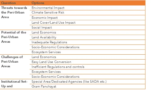
ESPA/ACCCRN - Is an unbuilt area of land available for development? 2 Special Area/Dedicated Agencies (like
SADA etc.)
1 Scientific Studies (like Land-Suitability Analysis etc.) 5 Compliance of the Stakeholders
Consultations
1 5 1 2 5 2
Note: Refer Annexure 7 & G-3Resource Persons’ workshop
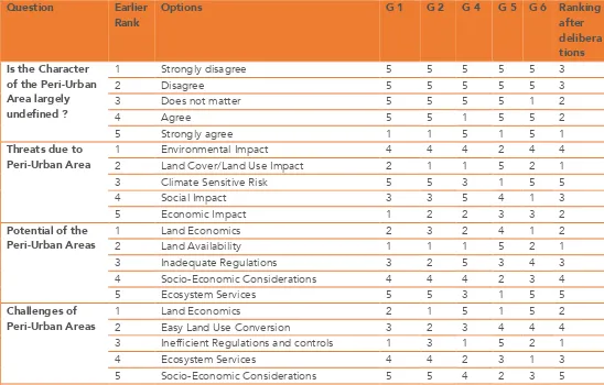
In the first half of the workshop, 5 groups of resource persons (each group comprising of 6–7 people) discussed the following headings (decided on from the responses to the Google form) and indicators within their respective groups. Each group had a heterogeneous combination of various professionals. Diverse experience and knowledge sharing influenced the outcomes.
Cause of the Development: Land economics, land availability and inadequate regulations were estimated as major causes of development in peri-urban areas.
ESPA/ACCCRN - Is an unbuilt area of land available for development?
Challenges: Main challenges of the peri-urban areas are perceived as land economics, easy land-use conversion and inefficient regulations. Lesser importance was given to ecosystem services and socio-economic considerations.
Institutional Set-Up: As per the survey of Gram Panchayat, special areas/dedicated agencies (like SADA etc.) and district agencies play major roles as institutional set-up and developmental
agencies, while metropolitan agencies and private agencies (on lease etc.) were not given importance.
Urban Limits: The foremost reasons for the extension of urban limits are found to be political and economic, for the extension of the revenue base and demographic reasons, whereas there was insignificant scientific basis for the extensions.
Preparedness: Scientific studies (like land-suitability analysis etc.) are not done to determine the preparedness of the periphery areas before their inclusion in the urban limits, while infrastructure development, administrative, technical, and environmental (ecosystem conservation) matters are also overlooked.
Public Participation: Most of the resource persons think effective public participation in the periphery areas can be ensured by involving the public in the decision-making process by
including local people in the decision-making bodies, while consent/approval-based mechanisms, which form part of the information system, and compliance with the stakeholders’ consultations comes as a later preference.
After deliberations and radically group decisions, the following were the outcomes:
Cause of Development: Land availability is considered to have more influence, rather than land economics and inadequate regulations, and be the major cause of the peri-urban areas.
Threats: Land cover/land-use impacts and economic impacts are considered to be the major threats, rather than the environmental impact and climate sensitive risks caused by peri-urban areas.
Challenges: Inefficient regulations and land economics are believed to be the main challenges of the peri-urban areas, followed by ecosystem services and the ease of land-use conversion. Lesser importance is still given to the socio-economic considerations.
Institutional Set-Up: Opinions remain the same about the participating authorities. As per the survey of Gram Panchayat (rural/local government), special area/dedicated agencies (like SADA, etc.) and the district agencies play major roles as the institutional set-up and developmental agencies, while the metropolitan agency and private agencies (on lease etc.) have less significance.
ESPA/ACCCRN - Is an unbuilt area of land available for development?
periphery areas, then follows political and economic reasons–the extension of the revenue base -while scientific measures are still considered the least important.
Preparedness: Infrastructure development, political and administrative considerations are more important than scientific studies (like land-suitability analysis etc.) for determining the
preparedness of periphery areas before their inclusion in the urban limits. At times, technical and environmental (ecosystem conservation) matters are considered later.
Public Participation: Similar to the online survey outcomes, resource persons also think effective public participation in the periphery area decisions can be ensured by involving the local people in the decision-making process. But more importance is given to compliance with the outcomes from the stakeholders’ consultations before including local members in the decision-making bodies, though making them part of the informed system and compliance with the stakeholders’ consultations comes as a later preference.
Table 2:Key findings of the perceptions of resource persons for the scoping scenario
Question 2 Special Area/Dedicated Agencies (like
ESPA/ACCCRN - Is an unbuilt area of land available for development?
1 Scientific Studies (like Land-Suitability Analysis etc.) 5 Compliance of the Stakeholders
Consultations 4 Social Implications (like inadequacy of
landholdings to sustain rural households)
2 4 4 4 1 4 2 Phase-wise or Transitional Plan
Development
3 2 3 4 2 3
3 Proper Legal and Administrative Controls 1 3 1 1 3 1 4 Long-Term Planning Approaches 2 1 2 2 4 2 5 Development of Surrounding
Infrastructure
5 4 5 3 5 5
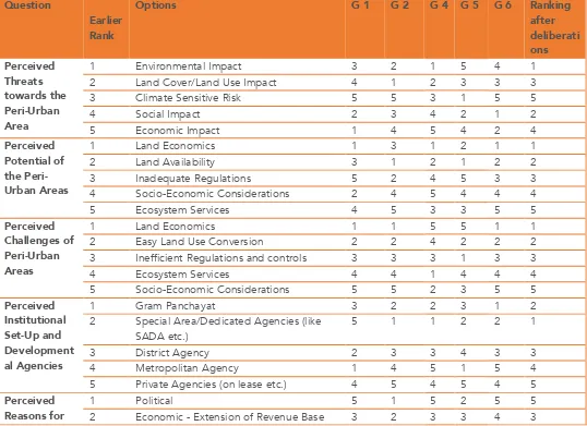
Note: Refer Table 1 & Annexure 8: G-3 was of resource personnel conducting a workshop
In the second half of the workshop, the activity was about the perceptions of the resource persons. Most of the groups agreed with the ranking of the parameters for the cause of development, challenges, preparedness and public participation, as the outcome of
understanding the scenario. In this case, the sequence for the importance of the parameters as perceived will remain the same for the mentioned headings. Their opinions are as follows:
Cause of the Development: Land economics, land availability and inadequate regulations risks are perceived as the major causes of development in peri-urban areas.
ESPA/ACCCRN - Is an unbuilt area of land available for development?
Preparedness: Scientific studies (like a land-suitability analysis etc.) are observed to be of the foremost important for the preparedness of periphery areas before inclusion in the urban limits, while infrastructure development, administrative, technical and environmental (ecosystem conservation) matters come later in the list of priorities.
Public Participation: Most of the resource persons think effective public participation for the periphery areas can be ensured by involving the public in the decision-making process, by
including local people in the decision-making bodies, while consent/approval-based mechanisms which form part of the information system and compliance with the outcome of the stakeholders’ consultations comes as a later preference.
Varied opinions were given on the following headings:
Threats: Environmental impact, land cover/land use impact and climate sensitive risks are perceived as major threats caused by peri-urban area development. This was followed by the social and economic impacts.
Institutional Set-Up: Resource persons’ opinions almost remain the same about the participating authorities. It is perceived that special area authority/dedicated agencies (like SADA etc.) shall address the issues followed by Gram Panchayat. District agencies play a major role as the institutional set-up and developmental agencies, while the metropolitan agency and private agencies (on lease etc.) are not given any importance
Urban Limits: Demographics is perceived as the foremost reasons for any extension of the urban limits, then scientific reasons. Extension of the revenue base, the addition of resource and political reasons are still considered the least important.
Losses: Ecosystem services, biodiversity and resources are likely to bear maximum losses due to peri-urban developments, followed by social implications (like the inadequacy of the landholdings to sustain rural households) and land revenue.
Solutions: Planned land use conversions and phase-wise or transitional plan developments seem to be effective measures for handling the challenges of peri-urban ignorance. Whereas proper legal and administrative controls, long-term planning approaches and the development of the surrounding infrastructure are given less importance.
Table 3: Final priority of aspects as perceived by resource persons
ESPA/ACCCRN - Is an unbuilt area of land available for development?
Special Area/Dedicated Agencies (like SADA etc.)
Gram Panchayat District Agency Metropolitan Agency
Private Agencies (on lease etc.)
Perceived Reasons for of Area before Inclusion in the Urban Limits
Scientific Studies (like Land-Suitability Analysis etc.)
Involved in the Decisions being made Members of the Decision Making Bodies Consent/Approval Based Mechanisms Part of Informed System
Compliance of the Stakeholders Consultations
Perceived Losses due to Peri-Urban Development
Ecosystem Services Resources Loss Land Revenue Loss
ESPA/ACCCRN - Is an unbuilt area of land available for development?
How to handle challenges of Peri-Urban Ignorance
Long-Term Planning Approaches
Proper Legal and Administrative Controls Planned Land Use Conversion
Phase-wise or Transitional Plan Development Development of Surrounding Infrastructure Note: Refer Tables 1 & 2
2.3.2 Outreach activity - Training Program
The training program for students and early-career professionals from different disciplines and domains was conducted to sensitize them, and for capacity building. They are the future
politicians, decision makers, professionals or civic society representatives. Students from several reputed engineering, science, arts and commerce institutes in Bhopal were invited to facilitate their proper involvement in the training program. Similarly, a few early-career professionals (candidates having work-experience of not more than 5 years), with different backgrounds and work-environments like architecture, planning, the arts, general science, law etc. were also invited. The active participation of around 30 students and young professionals across the domains of architecture, urban planning, basic sciences, economics, the arts and humanities ensured that the inputs provided by, as well as the outcomes received from this group, represented an adequate representative view of the different interest groups and stakeholders.
Since an inter-disciplinary participation was to be carried out in the training program, it was decided that a some cases would be given to them a few days before the start, so that they could clearly understand the activity, their participation in it, and the context. This ensured that on the day of the training program, almost every participant was on a level-playing field in terms of their basic understanding of the ideas, themes and the needs of the program. Everybody had liberty to handle the case with their knowledge and technical understanding, and come-up with different angles in handling cases.
The cases which were given to them and later discussed within their groups, and then finally reviewed with the direction and inputs given by resource persons a day before, are as follows:
1. The extension to the limits of Bhopal has now reached the area of Bhanpura in the
east, which was used as the most prominent solid waste dumping ground for the city. Now there are plans to relocate that dumping ground to another area, so that the Bhanpura area could also be developed properly, in order to cater to the rising demand for urban expansion in that area.
2. What challenges do you feel lie ahead in this regard, and what should be the ideal way out?
ESPA/ACCCRN - Is an unbuilt area of land available for development?
water supply. The current residential as well as commercial developments are adding to the demand, resulting in an extension of the limits by engulfing the peri-urban settlements lying there.
4. How do you perceive the development there? Is the growth scenario building of that area justifiable? What can be the threats, either existing or with proposed options, for that area?
5. Bhopal was once known for the many water-bodies in and around it. Most of these
are now extinct, or are in very bad shape today. While keeping this in view, what should be the way to protect and maintain these outskirts water bodies? Should the natural water-bodies, like Hathaikheda Dam, be considered with the same regard while proposing any development activity in the areas surrounding it? How should we approach such a situation vis-à-vis the previous cases of water resources depletion in the city?
6. Bhopal has been bestowed with a lot of greenery and vegetation. However, the gradual expansion of the city into these green spaces has raised concerns about deforestation. Ecological implications, like the cases of tiger sightings besides the Kaliasot Dam area, or the gradual decrease in the green cover in the Kerwa and Ratibad areas are alarming. Elucidate and discuss whether this ecological confrontation can be avoided in the course of a city’s growth? How can developmental as well as ecological concerns be managed effectively and efficiently?
In the training program, the participants were split into 5 groups (of 6–7 members each), with the idea that each group would comprise of participants from different domains/disciplines. These 5 groups were then asked to discuss each of the 4 cases presented before them, while actively seeking inputs from all the members of the group. Each group presented their findings. The brief of their opinions on these aforementioned 4 cases and the corresponding scenario building exercise, as deliberated, discussed, recorded and submitted by them is as follows:
Table 4: Four cases for the training program
Case 1: Pertaining to the Dumping Site
Group 1: The major focus was on the consideration of land as a limited resource and in the better management of the existing resources
Group 2: The focus was on how to avoid shifting the dumping site altogether, and the emphasis was to find better management practices for effectively handling the site
Group 3: The focus was on how to avoid shifting the dumping site by efficiently managing the existing site properly. However, the group also recommended a few approaches if moving it was unavoidable and had to be carried out in the future because of increasing urbanization.
ESPA/ACCCRN - Is an unbuilt area of land available for development?
Group 5: The focus was people-centric, i.e. they considered relocating and rehabilitating the population instead of the dumping site
Case 2: Development Along Hoshangabad Road, Bhopal
Group 1: The major focus was on the improvement of the governance related aspects
Group 2: The focus was on facilitating a proper land economics related analysis in place, so as to manage the land resources better
Group 3: The focus was on efficient and effective land use and developmental control regulations for better urban management of the peri-urban as well as the peripheral areas
Group 4: The focus was on implementation of the concept of transit oriented development as well as urban farming
Group 5: The focus was on having an institutional set-up addressing the infrastructure related requirements and challenges in place
Case 3: Depleting Water Bodies
Group 1: The major focus was on getting well-defined rules and regulations in place, good governance as well as the proper management of water resources
Group 2: The focus was on controlling the land developmental activities in areas adjacent to these water bodies
Group 3: The focus was on the conservation and restoration of the catchment areas concerning these water bodies
Group 4: The focus was on having strictly defined rules and regulations, and proper land use planning in the areas adjacent to these water bodies
Group 5: The focus was on having a proper drainage network and efficient groundwater recharge system in place
Case 4: Avoiding Ecological Confrontation
Group 1: The major focus was on using and incorporating the natural characteristics into the land-use planning of these peripheral areas
Group 2: The focus was on restricting the urban growth towards the eco-sensitive areas and to redirect it in other directions which are more suitable
Group 3: The focus was on the effective implementation of provisions and developmental control regulations prescribed in the development plan proposals
Group 4: The focus was on the restoration of fragmented forest areas as well as linkages of wildlife movement, and on increasing the buffer zones
ESPA/ACCCRN - Is an unbuilt area of land available for development?
Subsequent to this informal scenario building exercise, a few of the subject-experts gave lectures and demonstrated cases in the area of scenario building, the informal sector, traffic and
transportation, data collation and analysis, GIS and remote sensing and project management. Through a series of expert lectures given by experts like Dr. Alka Bharat, Mr. Sumit Gothi, Dr. K. K. Dhote, Dr. Anuj Jaiswal, Ms. Sumita Soni, Mr. Anugrah Nagaich, Dr. Vinay Mohan Das and others, the participants were educated, sensitized and capacity building carried out. With the experts’ inputs, the participants of the training program understood the sectoral potentials and challenges through the SWOT system i.e., Strengths, Weaknesses, Opportunities and Threats as present in the peri-urban as well as the peripheral urban areas.
Broad areas and a brief of the expert lectures are as follows:
a. Scenario Building: Participants were introduced to the process and benefits of scenario building and different techniques to develop alternative scenarios. Cases were
demonstrated of preparedness with resources, capabilities and skills through scientific scenario building exercises. One of the case exercises of the landfill site location through a scenario building approach was discussed.
b. Best Practices in Urban Planning and Management: The expert highlighted the various interrelations that exist between the design, architecture and planning aspects, and their subsequent impacts on urban planning and development. He presented and discussed several case studies to emphasize these aforementioned interrelations and impacts, and urged that more holistic solutions be found for the challenges associated with the peri-urban and peripheral areas.
c. Informal Sector: The expert shared and discussed his research experiences and findings pertaining to studies made by him into the informal sector located in the peri-urban and peripheral areas with the participants. His crucial insights regarding the challenges and opportunities, in regard to the informal sector, highlighted the importance of this often overlooked aspect in the overall planning, development and management processes for the urban areas.
d. Traffic and Transportation: The expert elucidated the importance of traffic and
transportation related aspects with respect to the peri-urban and peripheral areas of the city, and discussed the relevance, importance and applicability of several recent concepts like the transit oriented development etc. for addressing the challenges associated with these areas of the city.
ESPA/ACCCRN - Is an unbuilt area of land available for development?
how they can be effectively utilized to facilitate better simulation and modeling techniques for peri-urban and peripheral areas.
f. GIS and Remote Sensing: The expert presented the advancements which have taken place in the areas of remote sensing and GIS systems, and demonstrated their applicability, particularly in reference to the peri-urban and peripheral urban areas. He also shared a few case studies where these tools and technologies were effectively utilized for addressing various urban challenges.
g. Project Management: The expert discussed the importance of having an efficient and effective project management process and framework in place, while dealing with the issues and challenges of the urban development process. He showcased how urban problems, like those involving the peri-urban or peripheral areas, can get exaggerated in the absence of a proper project management framework. He also discussed the relevance of project management practices and various case-based examples taken from the
professional domain, and demonstrated the workability and improvements to the urban planning, development and management processes, while implementing the principals of project management.
ESPA/ACCCRN - Is an unbuilt area of land available for development?
C
HAPTER
3
A Case
3.1DETAIL
Bhopalis the capital of the central state of Madhya Pradesh and the administrative headquarters of Bhopal District and Bhopal Division. The city was the capital of the former Bhopal State. Bhopal is known as the City of Lakes for its various natural as well as artificial lakes, and is also one of the greenest cities in India. It is the 17th largest city in the country and the 131st in the world.
A Y-class city(Tier 2 – a classification by the government for the allocation of house rental allowances to public servants), it is home to the largest number of Institutes of National Importance in India, namely IISER, MANIT, SPA, and AIIMS.
The city attracted international attention in December 1984 after the Bhopal disaster, when
a Union Carbide India Limited (UCIL) pesticide manufacturing plant (now owned by Dow Chemical Company) leaked a mixture of deadly gases, composed mainly of methylisocyanate, leading to one of the worst industrial disasters in the world's history. The Bhopal disaster continues to be a part of the socio-political debate and a logistical challenge for the people of Bhopal.
Bhopal has been selected as one of the first twenty Indian cities to be developed as a smart city under PM Narendra Modi's flagship Smart Cities Mission. The city has been adjudged as the 21st cleanest city in India (https://en.wikipedia.org/wiki/Bhopal).
Bhopal is located at 23.25°latitude, 77.40°longitudewith an elevation of 523 meters above sea level. Bhopal is located in the central part of India, and is just north of the upper limit of
the Vindhya mountain ranges. Located on the Malwa plateau, it is higher than the North Indian plains and the land rises towards the Vindhya range to the south. The city has an uneven elevation because of small hills within its boundaries.
According to the 2011 census, the population of Bhopal City (the area under the Bhopal
ESPA/ACCCRN - Is an unbuilt area of land available for development?
the Bhopal metropolitan area (the urban agglomeration that extends beyond Bhopal city) was 1,886,100 in 2011.
The case of Bhopal is a very appropriate example of population growth and sprawling spatial boundaries. Over the yearsa very non-organised and ambiguous scenario has emerged in thehandling of its peri-urban areas, which is reflected in the changing morphology.
Ecosystem services provided by the periphery land and peri-urban areas were for the mitigation of air pollution, along with control of the rate of soil erosion and floods. They also provided space for recreational and educational activities. Due to the reduction in green cover (conversion of agricultural/forest land into built-up areas), there is a reduction in the soils’ pervious layer, an increase in CO2, an increase in runoff, more water logging (obstructing the natural drainage by building and waste), desertification (exposed land), air and water pollution (uncontrolled and organic activities) and damage to wildlife habitats.
Figure 1. Chronological development of Bhopal, Bhopal Development Plan 2005
Note: Compiled by: Girish Sakode, VIIth sem. B. Plan (2013-2017)
Figure 2. Chronological development of Bhopal
ESPA/ACCCRN - Is an unbuilt area of land available for development?
Bhopal has always been a seat of power and has the potential to attract people. There is always a huge influx of people to this settlement. The surrounding areas outside its administrative limits experience continuous changes in their built-up and land-use change characteristics. The settlement has grown and sprawled from the old walled city to its new expansion limits on the outskirts, which are on fertile agriculturalland, forest areas and even on catchment areas. Evidence in the literature can trace Bhopal’s existence back until 1000CE. By1722 the fortified City of Bhopal, also called ‘Sher-e-Khas’, covered an area of 1.5 sq. km.That has now increased to 685.88 km2.
The settlement could be distinctly divided into the core area, intermediate area, periphery and peri-urban area, based on its spatial and built-up characteristics. There is a vast difference in the patterns of governance, control and taxation system of different settlements on continuous patch of Urban Rural continuum of virtually appearing and acting continuous patch of land as urban rural continuum. This forces speculators to buy and use land in easier potential locations of the peri-urban areas and surrounding settlements.
Due to industrial development, the potential opportunities for employment and outside settlementshave raised the possibility of adding more built-up areas. This phenomena is also responsible for the spill-over of developments onto potentially high and comparatively cheaper land pockets.
In all the processes of the selection and developmentof new areas in the extended areas, generally no scientific system of identification, suitability and capability is being used. Broadly,a land suitability analysis isnow the only part of any development plan.
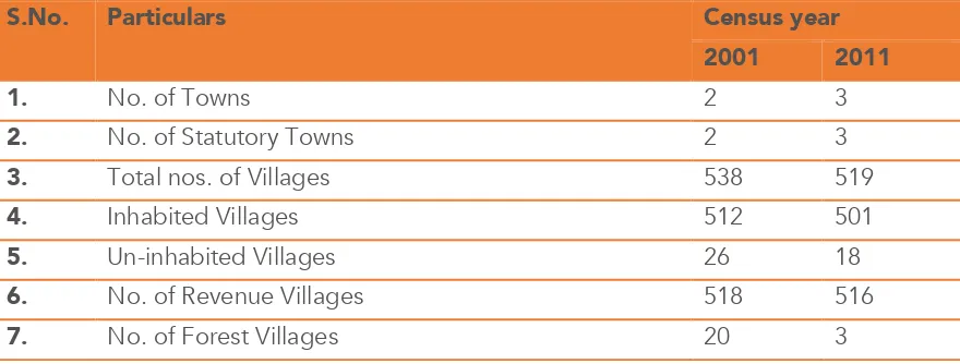
Table 5: Bhopaldistrict information, 2011
S.No. Particulars Census year
2001 2011
1. No. of Towns 2 3
2. No. of Statutory Towns 2 3
3. Total nos. of Villages 538 519
4. Inhabited Villages 512 501
5. Un-inhabited Villages 26 18
6. No. of Revenue Villages 518 516
ESPA/ACCCRN - Is an unbuilt area of land available for development?
Source: Bhopal District, census 2011
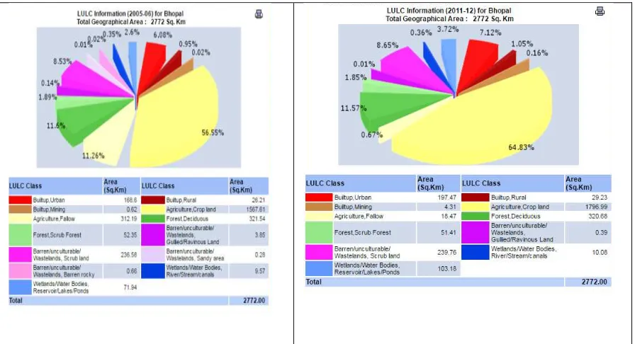
Table 6: Land use and land cover information for Bhopal District 2005-06 & 2011-12
8. Total Population 1,843,510 2,371,061
9. Decadal Population Growth 36.4 28.6
10. Proportion of Rural Population to Total Population 19.6 19.1
11. Proportion of Urban Population to Total Population 80.4 80.9
12. Population Density 665 855
ESPA/ACCCRN - Is an unbuilt area of land available for development?
ESPA/ACCCRN - Is an unbuilt area of land available for development?
C
HAPTER
4
Conclusion
1.1DETAIL
Bhopal’s periphery is predominantly for residential land-use. The peri-urban area is for
agricultural, industrial and residential landuse, and also supports unwanted urban activities like landfills.
It was decided that, on the basis of the given and suggested aspects’ priorities, the following should be the scope of concern and work for the peri-urban and periphery areas.
Settlements do not work within strict boundaries, with the flow of people, goods, resources and economies following no boundries. There is also a connection and dependency among all of these. The functional and governance system cannot work on divided grounds.
Adhoc methods and the partial use of scientific systems is seen there, like using software and other technical techniques for conducting surveys and preparing maps etc.
Table 7: Major concerns and suggested options
Question Options
ESPA/ACCCRN - Is an unbuilt area of land available for development?
Developmental Agencies
District Agency Metropolitan Agency
Private Agencies (on lease etc.)
Reasons for
Scientific Studies (like Land-Suitability Analysis etc.) Infrastructure Development
Involved in the Decisions being made Members of the Decision-Making Bodies Consent/Approval-Based Mechanisms Part of Informed System
Compliance of the Stakeholders Consultations
Losses due to
Social Implications (like inadequacy of landholdings to sustain rural households)
Proper Legal and Administrative Controls Planned Land Use Conversion
Phase-wise or Transitional Plan Development Development of Surrounding Infrastructure
Priorities, in the context of the periphery and peri-urban areas, that emerged from the interviews and e-mail survey are:
• Institutional set-up • Decisionmaking
• Governance
• Role of politicians, civic society , local governance , professionals
• Transparency and inclusive decision making • Metropolitan regional development agencies
• Losses -social, economical and environmental
ESPA/ACCCRN - Is an unbuilt area of land available for development?
• Environmental (ecosystem conservation)
• Physical planning
• Urban sprawl
• Land development controls
Priorities, in the context of the periphery and peri-urban areas, that emerged from the resource persons’ workshop are:
• Efficient regulations & controls
• Evidence-based and science based decisions
• Institutional set-up & governance
• Land economics
• Land use conversion
• Environment &ecosystem services
• Climate sensitive risk • Social impact
It is concluded through the different methods of identification used that the scope of the study and the concerns about the interaction of the periphery, peri-urban and ecosystem services should mainly encompass:
1. Institutional set-up
2. Role of government, bureaucrats and civil society 3. Decision making and governance
4. Spatial scale in context 5. Temporal scale context
6. Direct social, economic &environmental losses along with other indirect losses
To achieve a balance between the various environmental concerns, both scientific and resource management, along with preventive and precautionary measures, should be practiced
The scope of any studies, in the context of the periphery and peri-urban areas, can be mainly confined to regulations and controls, the institutional set-up and governance, land
economics, land use conversion, environmental and ecosystem services, climate sensitivity risks and social impacts.
ESPA/ACCCRN - Is an unbuilt area of land available for development?
R
EFERENCES
Allen L Clark, Environmental challenges to Urban Planning: Fringe areas , ecological footprints and climate change,
Decision Intelligence Document: Degradation and loss of Peri-Urban Ecosystems: Rockefeller Foundation, Nov. 2013
Development Plan of Bhopal, 1991 & 2005
Elizabeth Mylott; Urban-Rural Connections: A Review of the Literature
Eric Denis: Rural-Urban linkages: Indian case study, Working paper series, RIMISP, Oct. 2014
GALLEZ C, et al.; Landuse transport systems: Comparing local policy dynamics in Swiss and French urban areas, 12th WCTR, July 11-15, 2010 – Lisbon, Portugal
Hilary.Arksey, Lisa O’Malley, Scoping studies: Towards a methodological framework,
http://www.journalsonline.tandf.co.uk/openurl.asp?genre=article&eissn=1464-5300&volume=8&issue=1&spage=19
I. Douglas: Peri-Urban Ecosystems and Societies: Transitional Zones and Contrasting Values
J. Kleemanna et al., “Peri-urban land use pattern and its relation to land use planning in Ghana, West Africa, Landscape and Urban Planning Available online 22 March 2017
J. Ravetz, Christian Fertner, et al., The Dynamics of Peri-Urbanization, Springer-Verlag Berlin Heidelberg 2013
Jorge Goncalves, et. al. Differentiating Peri-Urban areas: A Transdisciplinary approach towards a typology, Land use policy, 63 ( 2017 )
L Louise et al.: MRC-NICE Scoping Project: Identifying the National Institute for Health and Clinical Excellence’s Methodological Research Priorities and an initial set of priorities
Mai T Pham et al. A Scoping review of scoping reviews: Advancing the approach and enhancing the consistency, https://www.ncbi.nlm.nih.gov/pmc/articles/PMC4491356/
ESPA/ACCCRN - Is an unbuilt area of land available for development?
Marcel Dijkers. What is a scoping review? Published in KT Update (Vol. 4, No. 1 – December 2015) [http://ktdrr.org/products/update/v4n1], An e-newsletter from the Center on Knowledge Translation for Disability and Rehabilitation Research
Marcus Hedblom, et. Al., Flexible landuse and undefined governance: From threats to potentials in peri –urban landscape planning, land use policy, 63 (2017)
Marcus Hedblom, Flexible landuse and undefined governance: From threats to potentials in peri-urban landscape planning, landuse policy, Elsevier publications, 2017
MP Land Revenue Code, 1959/2012
MP Nagar Ththa Gram Nivesh Niyam, 1975 Mumbai, cover story, Outlook, 15th August , 2005 Municipal Corporation Act, 1961
Pradyumna Prasad Karan. The pattern of Indian towns: A Study in Urban Morphology, journal of the American Institute of Planners, Published on-line, 18th Dec. 2007
S. Purushothaman et al: Social and Environmental Transformation in the Indian Peri-Urban Interface – Emerging questions: Working Paper I , Jan. 2016
Sandeep Parkhi. The concept of urban fringe and the basis for delineation: Case study of Pune city, Spatio-Economic Development Record, Vol. 10, No. 5, September – October, 2003
Sanjay B Verma, Devendra Nimbokar, Chandigarh Fringe. Area- A Critical Analysis, National Town Planning Congress, Chandigarh, Dec. 27-29 , 2002
The World Bank: Urbanisation beyond Municipal boundaries Town Planning Act, 1973
Utpal Sharma, Shobit Tayal, Peri-Urban Development: Alternative models for Ahmedabad, ‘Spatio-Economic Development Record’; Vol. 9 No. 5, Sep.- Oct. 2002
V.Narain et al. Peri-urbanisation in India, SaciWATERs 2013
ESPA/ACCCRN - Is an unbuilt area of land available for development?
A
NNEXURE
1
Bhopal -Periphery and Peri-Urban
ESPA/ACCCRN - Is an unbuilt area of land available for development?
A
NNEXURE
2
Stakeholders’ Questionnaire
Personal Details
Name (optional)
Place: Ward No.: Zone No.:
Period of Stay:
Questionnaire
Did you know before that your area is to become a part of the urban area?
Yes No
Did you want to be a part of the urban area?
Yes No
Is there any difference in your life after redefining the municipal limits?
Yes No
Haveany extreme climate related events taken place since there definition of municipal limits?
Yes No
What are the problems (like traffic congestion etc.) that you have you faced?
ESPA/ACCCRN - Is an unbuilt area of land available for development?
What benefits have you experienced since the merger?
Yes No
What suggestions do you have for this process to become gradually more acceptable?
Yes No
Did you ever think of the merger?
Yes No
Ranking the Basic Services (Before and After)
1. Water Supply
Before Very Good --- Good --– Neither Good nor Bad --– Bad --– Very Bad
After Very Good --- Good --– Neither Good nor Bad --– Bad --– Very Bad
2. Sanitation
Before Very Good --- Good --– Neither Good nor Bad --– Bad --– Very Bad
After Very Good --- Good --– Neither Good nor Bad --– Bad --– Very Bad
3. Sewerage
Before Very Good --- Good --– Neither Good nor Bad --– Bad --– Very Bad
After Very Good --- Good --– Neither Good nor Bad --– Bad --– Very Bad
4. Traffic and Transportation
ESPA/ACCCRN - Is an unbuilt area of land available for development?
After Very Good --- Good --– Neither Good nor Bad --– Bad --– Very Bad
5. Drainage
Before Very Good --- Good --– Neither Good nor Bad --– Bad --– Very Bad
After Very Good --- Good --– Neither Good nor Bad --– Bad --– Very Bad
A
NNEXURE
3
ESPA/ACCCRN - Is an unbuilt area of land available for development?
A
NNEXURE
4
ESPA/ACCCRN - Is an unbuilt area of land available for development?
A
NNEXURE
5
ESPA/ACCCRN - Is an unbuilt area of land available for development?
ESPA/ACCCRN - Is an unbuilt area of land available for development?
Annexure 6
Paper clippings about the workshop
A
NNEXURE
7
Questionnaire for Resource Persons’ workshop
Understanding-Present System
A1. Is the character of the peri-urban area largely undefined?
(Scale of 1 to 5, 1 being ”Do not agree” and 5 being “Strongly agree”)
On the basis of the responses received through the Google forms, different parameters have been put in order accordingly. If your view differs, change the sequence and write your justification to be discussed.
Place the following in order with respect to their relative importance
A2. Threats due to peri-urban areas
ESPA/ACCCRN - Is an unbuilt area of land available for development?
3. Climate sensitive risk 4. Social impact
5. Economic impact
A3. Potential of the peri-urban areas
1. Land economics 2. Land availability
3. Inadequate regulations
4. Socio-economic considerations 5. Ecosystem services
A4. Challenges of the peri-urban areas
1. Land economics
2. Easy landuse conversion 3. Inefficient regulations 4. Ecosystem services
5. Socio-economic considerations
A5. Institutional set-up and developmental agencies
1. Gram Panchayat
2. Special area/dedicated agencies (like SADA etc.) 3. District agency
4. Metropolitan agency
5. Private agencies (on lease etc.)
B1. Is the character of the periphery area largely undefined?
(scale of 1 to 5, 1 being ‘”Do not agree” and 5 being “Strongly agree”)
On the basis of the responses received, different parameters have been put in order accordingly. If you want to change the sequence, write your justification for your changes - to be discussed .
Place the following in order with respect to their relative importance
B2. Reasons for extension of urban limits
1. Political
ESPA/ACCCRN - Is an unbuilt area of land available for development?
4. Addition of resources 5. Scientific
B3. Preparedness of the area before its inclusion in the urban limits
1. Scientific studies (like land-suitability analysis etc.) 2. Infrastructure development
3. Administrative 4. Technical
5. Environmental (ecosystem conservation)
B4. Ensuring effective public participation
1. Involved in the decisions being made 2. Members of the decision-making bodies 3. Consent/approval-based mechanisms 4. Part of information system
5. Compliance with the stakeholders’ consultations
A
NNEXURE
8
Questionnaire for Resource Persons’ workshop
Perception
On the basis of the responses received, different parameters have been put in order accordingly. If you want to change the sequence, write your justification for the changes - to be discussed.
Order the following with respect to their relative importance
C1. Perceived threats towards the peri-urban area
1. Environmental impact 2. Land cover/land use impact 3. Climate sensitive risk 4. Social impact
5. Economic impact
ESPA/ACCCRN - Is an unbuilt area of land available for development?
2. Land availability
3. Inadequate regulations
4. Socio-economic considerations 5. Ecosystem services
C3. Perceived challenges of the peri-urban areas 1. Land economics
2. Easy landuse conversion
3. Inefficient regulations and controls 4. Ecosystem services
5. Socio-economic considerations
C4. Perceived institutional set-up and developmental agencies 1. Gram Panchayat
2. Special area/dedicated agencies (like SADA etc.) 3. District agency
4. Metropolitan agency
5. Private agencies (on lease etc.)
C5. Perceived reasons for extension of urban limits 1. Political
2. Extension of revenue base 3. Demographic
4. Addition of resources 5. Scientific
C6. Perceived preparedness of area before its inclusion in the urban limits 1. Scientific studies (like land-suitability analysis etc.)
2. Infrastructure development 3. Administrative
4. Technical
5. Environmental (ecosystem conservation)
C7. Perceived ways to ensure effective public participation 1. Involved in the decisions being made 2. Members of the decision-making bodies 3. Consent/approval-based mechanisms 4. Part of information system
ESPA/ACCCRN - Is an unbuilt area of land available for development?
C8. Perceived losses due to the peri-urban development
1. Ecosystem services 2. Land revenue loss 3. Biodiversity loss
4. Social implications (such as the inadequacy of landholdings to sustain rural households)
5. Resources loss
C9. How to handle the challenges of peri-urban ignorance 1. Planned land use conversion
2. Phase-wise or transitional plan development 3. Proper legal and administrative controls 4. Long-term planning approaches